Note: Descriptions are shown in the official language in which they were submitted.
CODED INTERLEAVED SIMULTANEOUS SOURCE
SHOOTING
CROSS-REFERENCE TO RELATED APPLICATIONS
[0001] This application claims benefit of U.S. provisional patent application
Serial No.
62/900,066 filed September 13, 2019, and entitled "Coded Interleaving
Simultaneous
Source Shooting," which is hereby incorporated herein by reference in its
entirety.
BACKGROUND
[0002] The present disclosure relates generally to seismic data acquisition,
and more
specifically, to simultaneous source shooting techniques to increase the
separability of
overlapping shots.
[0003] This section is intended to introduce the reader to various aspects of
art that
may be related to various aspects of the present disclosure, which are
described and/or
claimed below. This discussion is believed to be helpful in providing the
reader with
background information to facilitate a better understanding of the various
aspects of
the present disclosure. Accordingly, it should be understood that these
statements are
to be read in this light, and not as admissions of prior art.
[0004] A seismic survey includes generating an image or map of a subsurface
region
of the Earth by sending acoustic energy down into the ground and recording the
reflected acoustic energy that returns from the geological layers within the
subsurface
region. During a seismic survey, an energy source is placed at various
locations on or
above the surface region of the Earth, which may include hydrocarbon deposits.
Each
time the source is activated, the source generates a seismic (e.g., acoustic
wave) signal
that travels downward through the Earth, is reflected, and, upon its return,
is recorded
CA 03149970 2022-3-2
WO 2021/050289
PCT/US2020/048318
using one or more receivers disposed on or above the subsurface region of the
Earth.
The seismic data recorded by the receivers may be used to create an image or
profile
of the corresponding subsurface region.
100051 Seismic data acquisition can be a time consuming and expensive process.
One
technique to reduce the time and cost required to acquire seismic data is the
use of
two or more sources that are fired close in time to one another (Le., multiple
sources
are sequentially activated during a single recording period). However, while
this
technique may decrease the amount of time and cost associated with seismic
acquisition, the resultant seismic data may include noise. One example of this
noise is
blending noise, which refers to signals received during data collection
periods that
interfere with a current data collection period and may be read as noise
(e.g., weak-
coherence energy or signal) despite being part of a primary signal (e.g.,
coherent
energy or signal) for a subsequent input data (e.g., input seismic data)
collection
period. It may be desired to develop and/or improve techniques associated with
seismic acquisition that increase the incoherency of the resultant noise
generated from
the firing of two or more sources during a data collection period such that
the
resultant noise may be separated by data processing.
SUMMARY
100061 A summary of certain embodiments disclosed herein is set forth below.
It
should be understood that these aspects are presented merely to provide the
reader
with a brief summary of these certain embodiments and that these aspects are
not
intended to limit the scope of this disclosure. Indeed, this disclosure may
encompass
a variety of aspects that may not be set forth below.
2
CA 03149970 2022-3-2
WO 2021/050289
PCT/US2020/048318
[0007] Seismic acquisition utilizing sources and receivers may be useful in
the
generation of, for example, seismic images. Seismic images may be used, for
example, in the determination of hydrocarbon deposits (e.g., areas within a
subsurface
that contain hydrocarbons) and/or subsurface drilling hazards. Seismic images
are
generally produced using seismic waveforms produced by a source, reflected off
regions within a subsurface, and received by one or more receivers. However,
noise
associated with the seismic acquisition can render portions of the gathered
data
unusable.
[0008] Accordingly, present techniques include towing multiple source arrays
to
increase data density and / or reduce operation run time & cost. The
activation of
each array interleaves (i.e., flip flop acquisition for a dual-source-arrays
configuration) so that the source arrays are sequentially fired with respect
to one
another. The shot point positions of each arrays also are dithered, such that
the time
at which a shot is undertaken is offset by a random amount of time, for
example,
between approximately -250 milliseconds and +250 milliseconds (ms).
[0009] In other embodiments, to further increase the incoherency of noise, the
activations of the arrays are interleaved and their respective shot point
positions are
dithered and the source arrays are staggered. This staggering of at least one
array can
be accomplished via a positional offset between one of the arrays with respect
to
another of the arrays and/or a positional offset of at least one of the arrays
with
respect to the towing vessel. Alternatively, the staggering of the arrays can
be
accomplished via a shift in the shot point position (i.e., the time at which
the shot
point is made) for at least one array of the multiple arrays. The staggering
can be
applied to an array or shot point position in each sail line, and the
staggering can be
pre-defined or randomized (on a sail line by sail line or on a shot line by
shot line
3
CA 03149970 2022-3-2
WO 2021/050289
PCT/US2020/048318
manner) to create more randomness and incoherency resulting noise.
Furthermore,
when more than 2 seismic sources (e.g., arrays) are towed by the same source
vessel,
different shifts can be applied to each of the sources (e.g., arrays) to
produce stronger
incoherency of blending noise, creating a spatial coding pattern on the source
arrays
or shot point positions. Through application of the spatial coding to a source
array
geometry or source shot point positions, increases in the separability of
overlapping
shots can be achieved.
[0010] A benefit to utilizing staggering, dithering, and interleaving (or
other
sequenced array firing) is that neighboring lines no longer have the same
noise
pattern, which increases the randomness/incoherency of the blending noise,
thus
reduces the complexity of deblending of the received seismic data, especially
when
the data is sorted in 3D (or higher dimensions).
BRIEF DESCRIPTION OF THE DRAWINGS
[0011] Various aspects of this disclosure may be better understood upon
reading the
following detailed description and upon reference to the drawings in which:
[0012] FIG. 1 illustrates a flow chart of various processes that may be
performed
based on analysis of seismic data acquired via a seismic survey system, in
accordance
with embodiments presented herein;
[0013] FIG. 2 illustrates a marine survey system in a marine environment, in
accordance with embodiments presented herein;
[0014] FIG. 3 illustrates a second marine survey system in a marine
environment, in
accordance with embodiments presented herein;
4
CA 03149970 2022-3-2
WO 2021/050289
PCT/US2020/048318
[0015] FIG 4 illustrates a computing system that may perform operations
described
herein based on data acquired via the marine survey systems of FIG. 2 and/or
the
survey system of FIG. 3, in accordance with embodiments presented herein;
[0016] FIG. 5 illustrates a schematic of a technique of seismic acquisition,
in
accordance with embodiments presented herein;
[0017] FIG 6 illustrates a first technique of seismic acquisition in a marine
environment utilizing the marine survey system of FIG. 2 Of the second marine
survey
system of FIG. 3, in accordance with embodiments presented herein;
[0018] FIG. 7 illustrates an inline section view of seismic data gathered from
the
technique of FIG. 6, in accordance with embodiments presented herein;
[0019] FIG. 8 illustrates a second technique of seismic acquisition in a
marine
environment utilizing the marine survey system of FIG. 2 or the second marine
survey
system of FIG. 3, in accordance with embodiments presented herein;
[0020] FIG. 9 illustrates a third technique of seismic acquisition in a marine
environment utilizing the marine survey system of FIG. 2 or the second marine
survey
system of FIG 3, in accordance with embodiments presented herein;
[0021] FIG. 10 illustrates an inline section view of seismic data gathered
from the
technique of FIG 8 or FIG 9, in accordance with embodiments presented herein;
[0022] FIG. 11 illustrates a fourth technique of seismic acquisition in a
marine
environment utilizing the marine survey system of FIG. 2 or the second marine
survey
system of FIG. 3, in accordance with embodiments presented herein;
[0023] FIG. 12 illustrates a fifth technique of seismic acquisition in a
marine
environment utilizing the marine survey system of FIG. 2 or the second marine
survey
system of FIG. 3, in accordance with embodiments presented herein; and
5
CA 03149970 2022-3-2
WO 2021/050289
PCT/US2020/048318
[0024] FIG. 13 illustrates a sixth technique of seismic acquisition in a
marine
environment utilizing the marine survey system of FIG. 2 or the second marine
survey
system of FIG. 3, in accordance with embodiments presented herein.
DETAILED DESCRIPTION OF SPECIFIC EMBODIMENTS
[0025] When introducing elements of various embodiments of the present
disclosure,
the articles "a," "an," "the," and "said" are intended to mean that there are
one or
more of the elements. The terms "comprising," "including," and "having" are
intended to be inclusive and mean that there may be additional elements other
than the
listed elements. One or more specific embodiments of the present embodiments
described herein will be described below. hi an effort to provide a concise
description
of these embodiments, all features of an actual implementation may not be
described
in the specification. It should be appreciated that in the development of any
such
actual implementation, as in any engineering or design project, numerous
implementation-specific decisions must be made to achieve the developers'
specific
goals, such as compliance with system-related and business-related
constraints, which
may vary from one implementation to another. Moreover, it should be
appreciated
that such a development effort might be complex and time consuming, but would
nevertheless be a routine undertaking of design, fabrication, and manufacture
for
those of ordinary skill having the benefit of this disclosure.
[0026] Analysis of seismic data may provide valuable information, such as the
location and/or change of hydrocarbon deposits within a subsurface region of
the
Earth. The present disclosure generally discusses techniques that may be used
to
obtain seismic data with reduced noise by altering the acquisition techniques
and/or
6
CA 03149970 2022-3-2
WO 2021/050289
PCT/US2020/048318
locations for energy sources used in a seismic survey. Improvements to the
acquisition design allow for increases of the data density and provide
additional
advantages of increase efficiency.
[0027] By way of introduction, seismic data may be acquired by using a variety
of
seismic survey systems and techniques, examples of which are discussed with
respect
to FIG. 2 and FIG. 3. Regardless of the gathering technique utilized, after
the seismic
data is acquired, a computing system may analyze the acquired seismic data and
use
results of the seismic data analysis (e.g., seismogram, map of geological
formations,
or the like) to perform various operations within the hydrocarbon exploration
and
production industries. For instance, FIG. 1 illustrates a flow chart of a
method 10 that
details various processes that may be undertaken based on the analysis of the
acquired
seismic data. Although the method 10 is described in a particular order, it is
noted
that the method 10 may be performed in any suitable order.
100281 Referring now to FIG. 1, at block 12, locations and properties of
hydrocarbon
deposits within a subsurface region of the Earth associated with the
respective seismic
survey may be determined based on the analyzed seismic data. In one
embodiment,
the seismic data acquired via one or more seismic acquisition techniques may
be
analyzed to generate a map or profile that illustrates various geological
formations
within the subsurface region.
[0029] Based on the identified locations and properties of the hydrocarbon
deposits,
at block 14, certain positions or parts of the subsurface region may be
explored. That
is, hydrocarbon exploration organizations may use the locations of the
hydrocarbon
deposits to determine locations at the surface of the subsurface region to
drill into the
Earth. As such, the hydrocarbon exploration organizations may use the
locations and
7
CA 03149970 2022-3-2
WO 2021/050289
PCT/US2020/048318
properties of the hydrocarbon deposits and the associated overburdens to
determine a
path along which to drill into the Earth, how to drill into the Earth, and the
like.
[0030] After exploration equipment has been placed within the subsurface
region, at
block 16, the hydrocarbons that are stored in the hydrocarbon deposits may be
produced via natural flowing wells, artificial lift wells, and the like. At
block 18, the
produced hydrocarbons may be transported to refineries, storage facilities,
processing
sites, and the like, via transport vehicles, pipelines, and the like. At block
20, the
produced hydrocarbons may be processed according to various refining
procedures to
develop different products using the hydrocarbons.
[0031] It is noted that the processes discussed with regard to the method 10
may
include other suitable processes that may be based on the locations and
properties of
hydrocarbon deposits as indicated in the seismic data acquired via one or more
seismic survey. As such, it may be understood that the processes described
above are
not intended to depict an exhaustive list of processes that may be performed
after
determining the locations and properties of hydrocarbon deposits within the
subsurface region.
[0032] With the forgoing in mind, FIG. 2 illustrates a marine survey system 22
(e.g.,
for use in conjunction with block 12 of FIG. 1) that may be employed to
acquire
seismic data (e.g., waveforms) regarding a subsurface region of the Earth in a
marine
environment. Generally, a marine seismic survey using the marine survey system
22
may be conducted in an ocean 24 or other body of water over a subsurface
region 26
of the Earth that lies beneath a seafloor 28.
[0033] The marine survey system 22 may include a. vessel 30, one or more
sources
32, a streamer 34, one or more receivers 36, and/or other equipment that may
assist in
8
CA 03149970 2022-3-2
WO 2021/050289
PCT/US2020/048318
acquiring seismic images representative of geological formations within a
subsurface
region 26 of the Earth_ The vessel 30 may tow the one or more seismic sources
32
(e.g., an airgun array, another array of energy sources, a single energy
source, or a
combination thereof) that may produce energy, such as acoustic waves (e.g.,
seismic
waveforms), that is directed at a seafloor 28. The vessel 30 may also tow the
streamer 34 having the one or more receivers 36 (e.g., one or more
hydrophones) that
may acquire seismic waveforms that represent the energy output by the seismic
sources 32 subsequent to being reflected off of various geological formations
(e.g.,
salt domes, faults, folds, etc.) within the subsurface region 26.
Additionally, although
the marine survey system 22 is described with one or more seismic sources 32
(represented in FIG. 2 as an airgun array) and one or more receivers 36
(represented
in FIG. 2 as a plurality of hydrophones), it is noted that the marine survey
system 22
may include multiple seismic sources 32 and multiple seismic receivers 36. In
the
same manner, although the above descriptions of the marine survey system 22 is
described with one seismic streamer 34, it is noted that the marine survey
system 22
may include multiple seismic streamers 34. In addition, additional vessels 30
may
include additional seismic sources 32, streamers 34, and the like to perform
the
operations of the marine survey system 22.
[0034] FIG. 3 illustrates an Ocean Bottom Seismic (OBS) system as a second
marine
survey system 31 (e.g., for use in conjunction with block 12 of FIG. 1) that
also may
be employed to acquire seismic data (e.g., waveforms) regarding a subsurface
region
of the Earth in a marine environment. The OBS system may operate to generate
seismic data (e.g., OBS datasets). While the illustrated OBS system is an
Ocean
Bottom Cable (OBC) system inclusive of one or more receivers 33 disposed on
the
seafloor 28 coupled via a cable 35 to a second vessel 37, other embodiments of
an
9
CA 03149970 2022-3-2
WO 2021/050289
PCT/US2020/048318
OBS system, such as an Ocean Bottom Node (OBN) system or any other seismic
system that produces higher signal-to-noise images at differing frequencies
compared
to those of the marine survey system 22 may be utilized.
100351 As illustrated, the OBS system may include one or more seismic sources
32
(e.g., an airgun array, another array of energy sources, a single energy
source, or a
combination thereof) that is towed by a vessel 30 and which may produce
energy,
such as sound waves (e.g., seismic waveforms), that is directed at the
seafloor 28.
This energy may be reflected off of various geological formations within the
subsurface region 26 and subsequently acquired (e.g., received and/or
recorded) by
the one or more receivers 33 disposed on the seafloor 28. For example, data
may be
stored in the one or more receivers 33 for an extended period of time (e.g.,
hours,
days, weeks, or longer) prior to the stored data being retried (either via
cable 35 or
wirelessly). As illustrated, the one or more receivers 33 may be coupled to a
vessel
37 (and, in some embodiments, to one another) via the cable 35. Data acquired
via
the one or more receivers 33 may be transmitted via the cable 35 to the vessel
37 (or,
for example, wirelessly if the OBS system is an OBN system). Although the
marine
survey system 31 is described with one or more seismic sources 32 (represented
in
FIG. 3 as an airgun array), it is noted that the marine survey system 31 may
include
multiple seismic sources 32.
[0036] In some embodiments, the OBS system may be utilized to acquire OBS
damsels that are useful in reservoir mapping and characterization. These OBS
datasets typically have a bandwidth from approximately 2Hz to 100Hz with
relatively
high signal-to-noise ratio (SNR) results at low frequencies (e.g., at less
than or equal
to approximately 50Hz, 40Hz, 35Hz, etc.) relative to 3DHR datasets. Therefore,
the
to
CA 03149970 2022-3-2
WO 2021/050289
PCT/US2020/048318
OBS dataset is complementary with respect to bandwidth a 3DHR dataset acquired
via the marine survey system 22 (e.g., acquired via a 2D high-resolution
seismic
acquisition, a 3D high-resolution seismic acquisition, or the like).
100371 Although the methods and systems described herein are primarily
directed to
marine applications, they also may be applicable in land seismic operations.
Regardless of how the seismic data is acquired, a computing system (e.g., for
use in
conjunction with block 12 of FIG. 1) may analyze the seismic waveforms
acquired by
the seismic receivers 33 and/or 36 to determine information regarding the
geological
structure, the location and property of hydrocarbon deposits, and the like
within the
1C1 subsurface region 26. FIG. 4 illustrates an example of such a computing
system 60
that may perform various data analysis operations to analyze the seismic data
acquired
by the receivers 36, 44, or 46 to determine the structure of the geological
formations
within the subsurface region 26.
100381 Referring now to FIG. 4, the computing system 60 may include a
communication component 62, a processor 64, memory 66 (e.g., a tangible, non-
transitory, machine readable media), storage 68 (e.g., a tangible, non-
transitory,
machine readable media), input/output (I/O) ports 70, a display 72, and the
like. The
communication component 62 may be a wireless or wired communication component
that may facilitate communication between the receivers 36, 44, 46, one or
more
databases 74, other computing devices, and other communication capable
devices. In
one embodiment, the computing system 60 may receive receiver data 76 (e.g.,
seismic
data, seismograms) previously acquired by seismic receivers via a network
component, the database 74, or the like. The processor 64 of the computing
system
11
CA 03149970 2022-3-2
WO 2021/050289
PCT/US2020/048318
60 may analyze or process the receiver data 76 to ascertain various features
regarding
geological formations within the subsurface region 26 of the Earth.
[0039] The processor 64 may be any type of computer processor or
microprocessor
capable of executing computer-executable code or instructions to implement the
methods described herein. The processor 64 may also include multiple
processors
that may perform the operations described below. The memory 66 and the storage
68
may be any suitable article of manufacture serving as media to store processor-
executable code, data, or the like. These articles of manufacture may
represent
computer-readable media (e.g., any suitable form of memory or storage) that
may
store the processor-executable code used by the processor 64 to perform the
presently
disclosed techniques. Generally, the processor 64 may execute software
applications
that include programs that process seismic data acquired via receivers of a
seismic
survey according to the embodiments described herein.
[0040] The memory 66 and the storage 68 may also store the data, analysis of
the
data, the software applications, and the like. The memory 66 and the storage
68 may
represent tangible, non-transitory, computer-readable media (e.g., any
suitable form of
memory or storage) that may store the processor-executable code used by the
processor 64 to perform various techniques described herein. It may be noted
that
tangible and non-transitory merely indicates that the media is tangible and is
not a
signal.
[0041] The I/O ports 70 are interfaces that may couple to other peripheral
components
such as input devices (e.g., keyboard, mouse), sensors, input/output (I/O)
modules,
and the like. The I/O ports 70 may enable the computing system 60 to
communicate
with the other devices in the marine survey system 22 or the marine survey
system 31.
12
CA 03149970 2022-3-2
WO 2021/050289
PCT/US2020/048318
[0042] The display 72 may depict visualizations associated with software or
executable code processed via the processor 64. In one embodiment, the display
72
may be a touch display capable of receiving inputs from a user of the
computing
system 60. The display 72 may also be used to view and analyze results of any
analysis of the acquired seismic data to determine geological formations
within the
subsurface region 26, the location and/or properties of hydrocarbon deposits
within
the subsurface region 26, andVor the like. The display 72 may be any suitable
type of
display, such as a liquid crystal display (LCD), plasma display, or an organic
light
emitting diode (OLED) display, In addition to depicting the visualization
described
herein via the display 72, it may be noted that the computing system 60 may
also
depict the visualization via other tangible elements, such as paper (e.g., via
printing),
or the like.
100431 With the foregoing in mind, the present techniques described herein may
also
be performed using a supercomputer employing multiple computing systems 60, a
cloud-computing system, or the like to distribute processes to be performed
across
multiple computing systems. In this case, each computing system 60 operating
as part
of a super computer may not include each component listed as part of the
computing
system 60. For example, each computing system 60 may not include the display
72
since the display 72 may not be useful for a supercomputer designed to
continuously
process seismic data,.
[0044] After performing various types of seismic data processing, the
computing
system 60 may store the results of the analysis in one or more databases 74.
The
databases 74 may be communicatively coupled to a network that may transmit and
receive data to and from the computing system 60 via the communication
component
13
CA 03149970 2022-3-2
WO 2021/050289
PCT/US2020/048318
62, In addition, the databases 74 may store information regarding the
subsurface
region 26, such as previous seismograms, geological sample data, seismic
images, or
the like regarding the subsurface region 26.
[0045] Although the components described above have been discussed with regard
to
the computing system 60, it may be noted that similar components may make up
the
computing system 60. Moreover, the computing system 60 may also be part of the
marine survey system 22 Of the marine survey system 31, and thus may monitor
and/or control certain operations of the seismic sources 32 or 40, the
receivers 36,44,
46, or the like. Further, it may be noted that the listed components are
provided as
example components, and the embodiments described herein are not to be limited
to
the components described with reference to FIG. 4.
100461 In some embodiments, the computing system 60 (e.g., the processor 64
operating in conjunction with at least one of the memory 66 or the storage 68)
may
generate a two-dimensional representation or a three-dimensional
representation of
the subsurface region 26 based on the seismic data received via the receivers
mentioned above. Additionally, seismic data associated with multiple
source/receiver
combinations may be combined to create a near continuous profile of the
subsurface
region 26 that may extend for some distance. In a two-dimensional (2-D)
seismic
survey, the receiver locations may be placed along a single line, whereas, in
a three-
dimensional (3-D) survey, the receiver locations may be distributed across the
surface
in a grid pattern. As such, a 2-D seismic survey may provide a cross sectional
picture
(vertical slice) of Earth layers present directly beneath the recording
locations. A 3-D
seismic survey, on the other hand, may create a data "cube" or volume that may
correspond to a 3-D picture of the subsurface region 26.
14
CA 03149970 2022-3-2
WO 2021/050289
PCT/US2020/048318
[0047] In addition, a four-dimensional (4-D) or time-lapse seismic survey may
include seismic data acquired during a 3-D survey at multiple times. Using the
different seismic images acquired at different times, the computing system 60
may
compare the two images to identify changes in the subsurface region 26.
[0048] In any case, a seismic survey may include a large number of individual
seismic recordings (e.g., seismic traces, traces). As such, the computing
system 60
may analyze the acquired seismic data and obtain an image representative of
the
subsurface region 26. The computing system 60 may use the image to determine
locations and/or properties of hydrocarbon deposits. To that end, a variety of
seismic
1C1 data processing algorithms may be used to remove noise from the
acquired seismic
data, migrate the pre-processed seismic data, identify shifts between multiple
seismic
images, align multiple seismic images, or the like.
[0049] After the computing system 60 analyzes the acquired seismic data, the
results
of the seismic data analysis (e.g., seismogram, seismic images, map of
geological
formations, etc.) may be used to perform various operations within the
hydrocarbon
exploration and production industries. In some embodiments, the computing
system
60 may provide an indication of the presence of hydrocarbons. As such, the
computing system 60 may provide an indication of the subsurface region 26 that
is
likely to have hydrocarbons and provide a position (e.g., coordinates or a
relative
area) of regions that include the hydrocarbon deposits and/or (in some cases)
subsurface drilling halyards. In other embodiments, the image generated in
accordance with the present techniques may be displayed via the display 72 of
the
computing system 60, thus facilitating locating a region by a user of the
computing
CA 03149970 2022-3-2
WO 2021/050289
PCT/US2020/048318
system 60. One technique utilized to acquire the seismic data used to provide
a
seismic data analysis is illustrated in FIG. 5.
[0050] FIG. 5 illustrates schematically an embodiment of a technique and
system
used in seismic acquisition. In general, the technique entails firing seismic
sources 78
within a source array 80 according to a firing pattern 82. Thereafter, after a
period of
time 83, seismic sources 84 within a second source array 86 are fired
according to a
second firing pattern 88. In this manner, FIG. 5 illustrates a flip flop
shooting
technique or method in which one source array 80 is activated (i.e., one or
more
seismic sources 78 are activated), thereafter, after a period of time 83, the
source array
86 is activated (i.e., one or more seismic sources 84 are activated), and
thereafter, the
process repeats.
10051111 should be noted that each of the firing patterns 82 and 88 are
presented for
illustrative purposes only and should not be construed as limiting in any way.
Moreover, it should be appreciated that while firing pattern 82 differs from
firing
pattern 88, in some embodiments, the firing of seismic sources 78 and 84 may
be
duplicated such that firing pattern 82 and firing pattern 88 are a common
firing
pattern. Likewise, the period of time 83 may be any suitable non-zero time
period
and may be varied or may remain consistent. When the period of time is varied,
the
variance can be random, pseudo-random, or according to a pattern.
[0052] As illustrated in FIG. 5, the seismic sources 78 and 84 (represented by
Si
through S8) are air guns. As illustrated, Si and S2 represent the same type of
large
volume air gun, S3 through S5 represent the same type of medium volume air
gun,
and S6 through S8 represent the same type of small volume airgun. However, it
should be noted that any ntunber, volume and type of seismic sources 78 and 84
may
16
CA 03149970 2022-3-2
WO 2021/050289
PCT/US2020/048318
be included in each source array 80 and source array 86. For example, the
seismic
sources 78 may be high frequency sources while the seismic sources 84 are low
frequency sources. Indeed, the seismic sources 78 may be any seismic source
known
to those of skill in the art. For example, one or more of the seismic sources
78 and 84
can be a source which repeatedly emits a single pulse of energy as opposed to
a
continuous sweep of energy, i.e., an impulsive seismic source. Examples of
suitable
impulsive seismic sources may include without limitation, air guns, gas guns,
water
guns, charges, explosives, combinations thereof, and the like. Likewise, other
more
continuous or non-impulsive sources might also be employed, such as without
limitation, vibrators, resonators, sirens, and combinations thereof.
Furthermore, it is
noted that each of the source array 80 and the source array 86 may represent
one of
the seismic sources 32 of FIGS. 2 and 3.
100531 The firing patterns 82 and 88 may be generated before a survey is
undertaken.
The firing patterns 82 and 88 can be loaded onto, for example, one or more
controllers
that control firing of the seismic sources 78 or 84. Alternatively, the firing
patterns 82
and 88 generated in real time during the seismic survey by the one or more
controllers. The one or more controllers can, for example, rim code or other
instructions stored in a memory via a processor of the controller to generate
and/or
implement the firing patterns 82 and 88. The one or more controllers can be
located,
for example, on the vessel 30 or may be disposed on or otherwise coupled to
the
source array 80 and the source array 86_ The firing pattern 82 generally
comprises a
set of random time intervals or delays between the firing (activation) of each
seismic
source 78. Likewise, the firing pattern 88 generally comprises a set of random
time
intervals or delays between the firing (activation) of each seismic source M.
An
algorithm or program may be used (e.g., by the controller) to generate firing
patterns
17
CA 03149970 2022-3-2
WO 2021/050289
PCT/US2020/048318
82 and 88 and seismic signals acquired from these firing patterns 82 and 88
may be
processed by any methods known to those of skill in the art.
[0054] The firing patterns 82 and 88 may be combined with any suitable
simultaneous
seismic sourcing or acquisition techniques known to those of skill in the art.
Examples of simultaneous seismic shooting techniques include without
limitation,
independent simultaneous sourcing, self simultaneous sourcing with one or more
sources/arrays, firing shots on pre-defined shot point positions (locations)
with natural
time dithering introduced by varying source boat speed, firing shots with pre-
calculated random time dithering, or combinations thereof In another
embodiment, a
plurality of arrays may be employed where a first source array 80 is shooting
with
firing patterns and at least a second source array 86 is shooting with either
a self
simultaneous sourcing method or with a conventional shooting technique (i.e.
same or
consistent time delays or period between firing patterns). The source array 80
and
source array 86 may be synchronized or unsynchronized with one another. In
other
embodiments, firing patterns are not used. Instead, two or more source arrays
80 and
86 may be employed where each source array 80 and 86 may each be firing with
alternative simultaneous seismic shooting techniques including without
limitation,
independent simultaneous sourcing, self simultaneous sourcing with one or more
sources/mays, firing shots on pre-defined shot point positions with natural
time
dithering introduced by varying source boat speed, firing shots with pre-
calculated
random time dithering, or combinations thereof
[0055] In another exemplary embodiment, source array 80 may be shooting with
firing patterns, and at least source array 86 (as well as one or more
additional source
arrays) may be shooting using an independent simultaneous sourcing technique,
18
CA 03149970 2022-3-2
WO 2021/050289
PCT/US2020/048318
where all of the arrays may be synchronized, unsynchronized, random or pseudo-
random with respect to one another. It is contemplated that any number of
sources
and/or source arrays may be used where each source and/or source array may be
shooting with any combination of simultaneous sourcing or acquisition
techniques
such as without limitation, discrete firing patterns, continuous firing
patterns,
independent simultaneous sourcing, self simultaneous sourcing, or combinations
thereof. When a plurality of sources or source arrays are used, each source or
source
array may also combine different simultaneous shooting techniques, if
possible, such
as firing patterns in conjunction with self simultaneous sourcing,
[0056] As illustrated in FIG. 5, the source arrays 80 and 86 are fired or
activated
independently of on another. Furthermore, each activation of a source array 80
and
86 may use a different firing pattern. The source arrays 80 and 86 may be
coordinated/synchronized with another or unsynchronized. This is a variation
of
independent simultaneous sourcing. In yet another embodiment, for example,
source
array 80 may shoot with discrete firing patterns and a source array 86 may
shoot with
continuous firing patterns.
[0057] FIG. 6 illustrates marine seismic signal acquisition utilizing a first
technique.
As illustrated, the vessel 30 is towing two sources (i.e., source array 80 and
source
array 86, although single seismic sources can be utilized in place of either
Of both of
source array 80 and source array 86) so as to improve the operation efficiency
(i.e., to
increase data density and/or reduce operation run time and cost. In the
illustrated
embodiment, the vessel 30 includes a controller 90 (described previously in
conjunction with FIG. 5). The vessel 30 may be a portion of marine survey
system 22
or marine survey system 31 (i.e., the marine seismic signal acquisition of
FIG. 6 can
19
CA 03149970 2022-3-2
WO 2021/050289
PCT/US2020/048318
be utilized in conjunction with marine survey system 22 and/or marine survey
system
31).
[0058] The controller 90 may operate to generate and transmit a control signal
to the
source array 80 and/or the source array 86 to fire (i.e., for one or more of
the seismic
sources 78 and 84 therein to be fired), as discussed above in conjunction with
FIG. 5.
In some embodiments, the controller 90 may include a processor, an integrated
circuit, or other electronic processing circuitry capable of executing
computer-
executable code or instructions to implement the methods described herein. The
controller 90 can also include memory, storage, and/or other suitable articles
of
manufacture that can serve as media to store processor-executable code, data,
or the
like. These articles of manufacture may represent computer-readable media
(e.g., any
suitable form of memory or storage) that may store the processor-executable
code
used by the controller 90 processor 64 to perform the presently disclosed
techniques.
[0059] Generally, the controller 90 may execute a software application and/or
an
algorithm to generate one or more control signals to control the operation
(e.g., firing)
of the source array 80 and/or source array 86. In other embodiments,
individual
controllers 90 can each be dedicated to a respective source array 80 and
source array
86 to generate one or more control signals to control their respective
operation.
Furthermore, while only two source arrays 80 and 86 are illustrated, more than
two
sources or arrays may be utilized in conjunction with the techniques described
herein
(for example, as illustrated in conjunction with FIG. 8 described hereafter).
[0060] As illustrated, the vessel 30 tows source array 80 along a shot line 92
and the
vessel 30 tows source array 86 along shot line 94. These shot lines 92 and 94
(and,
accordingly, the source array 80 and the source array 86) may be a distance 95
apart,
CA 03149970 2022-3-2
WO 2021/050289
PCT/US2020/048318
for example, 50 meters or another value. Source array 80 fires shots (e.g., at
shot
point positions 85, 87, 89, 91, and 93) each separated by a distance 96, for
example,
25 meters. Likewise, source array 86 fires shots (e.g., at shot point
positions 97, 99,
101, 103, and 105) also separated by a distance 96, for example, 25 meters.
Furthermore, source array 86 can fire shots between the shots of source array
80, for
example, shot point position 97 at a distance 98 from shot point position 85
of the
source array 80. As illustrated, in the dual-source-array configuration this
distance 98
may be the midpoint of distance 96, for example, 12.5 meters, although other
values
for distance 98 are contemplated especially when more than 2 source arrays are
deployed. Likewise, source array 80 can fire shots between the shots of source
array
86, for example, shot point position 87 at a distance 100 from the shot point
position
97 of the source array 86. As illustrated, in the dual-source-array
configuration this
distance 100 may be the midpoint of distance 96, for example, 12.5 meters,
although
other values for distance 100 are contemplated.
100611 The controller 90, for example, can control the distances 96, 98, and
100
through issuance of control signals causing the source arrays 80 and 86 to
fire at
desirable and/or predetermined times associated with desired andlor
predetermined
values for distances 96, 98, and 100. The controller 90 can generate the
control
signals in accordance with instructions loaded thereon or the control signals
may be
determined and generated in real time during the seismic survey by the
controller 90.
100621 In some embodiments, one or more of the shot point positions 85, 87,
89, 91,
and 93 and the shot point positions 97, 99, 101, 103, and 105 are additionally
dithered. That is, the controller 90 generates the control signals so that the
actual
position of one or more of the shot point positions 85, 87, 89, 91, 93, 97,
99, 101, 103,
21
CA 03149970 2022-3-2
WO 2021/050289
PCT/US2020/048318
and 105 are adjusted by a small amount. This amount may be a fraction of a
second,
for example, between approximately negative 250ms and positive 250ms or
another
value typically less than one second and may cause the actual position of one
or more
of the shot point positions 85, 87, 89, 91, 93, 97, 99, 101, 103, and 105 to
be moved at
a distance 102 (i.e., Ax) from the illustrated locations of the shot point
positions 85,
87, 89, 91, 93, 97, 99, 101, 103, and 105, whereby, for example, distance 102
is less
than the distances 96, 98, and 100. The dithering of the actual position of
one or more
of the shot point positions 85, 87, 89, 91, 93, 97, 99, 101, 103, and 105
described
above are varied and the variance can be random, pseudo-random, or according
to a
pattern.
100631 FIG, 7 illustrates an inline (along shot line direction) section view
of seismic
data gathered (e.g., a common receiver gather) from the technique of FIG. 6_
Graph
106 corresponds to seismic data from shot line 92 and graph 108 corresponds to
seismic data from shot line 94. Likewise, data signals 110 or noise correspond
to
shots from sources 78 while data signals 112 or noise correspond to shots from
sources 84. As previously described in conjunction with FIG. 6, when
performing
source acquisitions of seismic data, the seismic source array 80 transmits a
first signal
at a first time (corresponding to shot point position 87), the seismic source
array 86
transmits a second signal at a second time (corresponding to shot point
position 97),
and the seismic source array 80 transmits a third signal at a third time
(corresponding
to shot point position 85), whereby the third time is at a time later than the
second
time and the second time is at a time later than the first time. As
illustrated, time 115
is the recording time window starting from the shot time of respective shots.
All
seismic signals that travel back to the recording device within the time
window are
displayed in the figure. The value of time 115 may be any number. Hereby, in
FIG.
22
CA 03149970 2022-3-2
WO 2021/050289
PCT/US2020/048318
7, time 115 is selected to be equal to the nominal time between any two shot
points
from a given line (e.g., shot point position 87 and shot point position 85),
while time
113 is the time between a shot point from shot line 92 and the next shot point
in time
from line 94 (e.g., shot point position 97 and shot point position 85)
excluding the
variations introduced by the dithering of shot time.
100641 Thus, although not outputted at the same time, the first signal at the
first time
(corresponding to shot point position 87, although not the first signal in the
illustrated
series) and the second signal at the second time (corresponding to shot point
position
97) may be transmitted relatively close in time (at time 113), such that there
is a
possibility of non-noise signal interference during reception of the first
signal by the
reception of the second signal. Thus, sometimes at least a portion of the
second signal
is received by the seismic receivers 33 and/or 36 when the seismic receivers
33 and/or
36 are expecting to receive the first signal.
100651 In this way, the data gathered corresponding to the first signal may
include
data corresponding to the second signal. If this occurs, the second signal
showing up
in the data for the first signal may be considered non-noise signal
interference, weak-
coherence signals, or blending noise. Since the second signal may be different
(e.g.,
affected by different formations than the first signal) than the first signal,
preemptively combining the two signals for data analysis may be improper and
subsequently cause interference in the data recovered for the signal
transmitted at the
first time.
100661 To help illustrate, a primary signal data (the portion of the data
signal 110 in
graph 106) may correspond to data gathered corresponding to the primary signal
of
multiple seismic source excitations (namely, shots at shot point positions 85,
87, 89,
91, and 93) that travel through one or more features inside earth and return
to a
23
CA 03149970 2022-3-2
WO 2021/050289
PCT/US2020/048318
seismic receiver. For example, the source array 80 may have transmitted the
first
signal at a first time, and, at a later time, the seismic receivers 33 and/or
36 may have
received data corresponding to the first signal. Before the seismic receiver
33 and/or
36 completes recording the first signal, the source array 86 may transmit
another
signal and get recorded. The seismic receivers 33 and/or 36 may continue to
record
until at least a portion of the shots (e.g., some shots, many shots, all
shots) have been
recorded. Shifting the continuous recording to align the time zeros to the
times of
seismic source excitations may generate the gather data (commonly called a
common
receiver gather or a gather, but herein referred to as "gather") depicted in
the graph
106.
100671 Data gathered in graph 106 includes the primary signal data (e.g., the
actual
signal associated with the main response of the signal from the source array
80 and
multiple excitations toward one or more features or formations being analyzed
as part
of the seismic data collection, coherent signal) and blending noise (the
portion of data
signal 112 in graph 106). The blending noise may overlap with relevant signal
data
that is relatively weak compared to the primary signal data.
100681 Similarly, second primary signal data (the portion of the data signal
112 in
graph 108) may correspond to data gathered corresponding to the primary signal
of
multiple seismic source excitations (namely, shots at shot point positions 97,
99, 101,
103, and 105) that travel through one or more features inside earth and return
to a
seismic receiver. Data gathered in graph 108 includes the second primary
signal data
(e.g., the actual signal associated with the main response of the signal from
the source
array 86 and multiple excitations toward one or more features or formations
being
analyzed as part of the seismic data collection, coherent signal) and second
blending
noise (the portion of data signal 110 in graph 108). The second blending noise
may
24
CA 03149970 2022-3-2
WO 2021/050289
PCT/US2020/048318
overlap with relevant signal data that is relatively weak compared to the
second
primary signal data.
100691 Sometimes signal processing operations cause the discarding or
disregarding
of the blending noise and the second blending noise. However, it may not be
desirable to ignore the blending noise and the second blending noise when
isolating
the primary signal and the second primary signal, respectively. To isolate the
primary
signal and the second primary signal, separation operations may be performed
on the
gather data. However, these separation operations may inadvertently cause at
least a
misallocation of the blending noise and the second blending noise. In this
way,
valuable seismic data that overlaps with the blending noise and the second
blending
noise may be lost when the blending noise and the second blending noise is
misestimated.
100701 The blending noise of graph 106 and the second blending noise of graph
108
illustrates examples of self simultaneous noise (i.e., due to the close
proximity of
source array 80 and source array 86 separated by distance 95). Deblending of
the self
simultaneous noise (SSN) tends to leave higher amount of residual noise (e.g.,
relative
to independent simultaneous noise generated by other sources) due to weak
coherence
of signal overlapping with the SSS noise. To avoid S SS noise overlapping with
target
signals, alternative acquisition techniques may be employed and these
techniques also
operate to improve the deblending process relative to the technique outlined
in
conjunction with FIG. 6.
100711 FIG. 8 illustrates a second technique of seismic acquisition in a
marine
environment utilizing the marine survey system 22 and/or the marine survey
system
31. As illustrated, the vessel 30 is towing two sources (i.e., source array 80
and
source array 86, although single seismic sources can be utilized in place of
either or
CA 03149970 2022-3-2
WO 2021/050289
PCT/US2020/048318
both of source array 80 and source array 86) so as to improve the operation
efficiency
(i.e., to increase data density and/or reduce operation run time and cost. In
the
illustrated embodiment, the vessel 30 includes the controller 90 (described
previously
in conjunction with FIGS. 5 and 6) that operates generate and transmit a
control signal
to the source array 80 and/or the source array 86 to fire (i.e., for one or
more of the
seismic sources 78 and 84 therein to be fired). In some embodiments, the
controller
90 may include a processor, an integrated circuit, or other electronic
processing
circuitry capable of executing computer-executable code or instructions to
implement
the methods described herein. The controller 90 can also include memory,
storage,
and/or other suitable articles of manufacture that can serve as media to store
processor-executable code, data, or the like. These articles of manufacture
may
represent computer-readable media (e.g., any suitable form of memory or
storage) that
may store the processor-executable code used by the controller 90 processor 64
to
perform the presently disclosed techniques with respect to FIG. 8.
100721 Generally, the controller 90 may execute a software application and/or
an
algorithm to generate one or more control signals to control the operation
(e.g., firing)
of the source array 80 and/or source array 86. In other embodiments,
individual
controllers 90 can each be dedicated to a respective source array 80 and
source array
86 to generate one or more control signals to control their respective
operation.
Furthermore, while only two source arrays 80 and 86 are illustrated, more than
two
sources or arrays may be utilized in conjunction with the techniques described
herein
(as will be described in conjunction with FIGS. 11-13).
100731 As illustrated, the vessel 30 tows source array 80 along a shot line 92
and the
vessel 30 tows source array 86 along shot line 94. These shot lines 92 and 94
(and,
26
CA 03149970 2022-3-2
WO 2021/050289
PCT/US2020/048318
accordingly, the source array 80 and the source array 86) may be a distance 95
apart,
for example, 50 meters or another value. Source array 80 fires shots (e.g., at
shot
point positions 85, 87, 89, 91, and 93) each separated by a distance 96, for
example,
25 meters. Likewise, source array 86 fires shots (e.g., at shot point
positions 114,
116, 118, 120, and 122) also separated by a distance 96, for example, 25
meters.
Furthermore, source array 86 can fire shots between the shots of source array
80, for
example, shot point position 114 at a distance 98 modified by distance 124.
That is,
the marine survey system 22 and/or the marine survey system 31 can be
initially set
up to have the controller 90 generate shots at shot point positions 114, 116,
118, 120,
and 122 that are not at a midpoint of distance 96. This distance 124 is be a
fixed
value, for example, approximately 1 meter, approximately 2 meters,
approximately 3
meters, or another value or the distance 124 may approximately be between 1
meter
and 4 meters, between 1 meter and 3 meters, between 1 meter and 2 meters,
between
2 meters and 3 meters, between 2 meters and 4 meters, or another value.
Alternatively, the distance 124 may be approximately 10%, 15%, 20%, 25%, 30%,
35%, 40%, 45%, 50%, 55%, 60%, 65%, 70%, 75%, 80%, 85%, 90%, 95% or 100% of
distance 98 or approximately 10%, 15%, 20%, 25%, 30%, 35%, 40%, 45%, or 50% of
distance 96.
[0074] The controller 90, for example, can control the distances 96, 98, 100,
and 124
through issuance of control signals causing the source arrays 80 and 86 to
fire at
desirable and/or predetermined times associated with desired and/or
predetermined
values for distances 96, 98, 100, and 124. The controller 90 can generate the
control
signals in accordance with instructions loaded thereon or the control signals
may be
determined and generated in real time during the seismic survey by the
controller 90.
Indeed, as illustrated in FIG. 8, the controller 90 generates control signals
that alter
27
CA 03149970 2022-3-2
WO 2021/050289
PCT/US2020/048318
the timing of the shot point positions 114, 116, 118, 120, and 122 relative to
the
timing of the shot point positions 97, 99, 101, 103, and 105 (i.e., thus
causing the shift
in distance 124 for each of the shot point positions 114, 116, 118, 120, and
122). The
shift in distance 124 of the actual position of one or more of the shot point
positions
114, 116, 118, 120, and 122 described above may be varied and the variance can
be
random, pseudo-random, or according to a pattern; however, once shifted, the
distance 124 remains fixed at least for a given shot line 94. It should be
noted that
movement of distance 124 may be positive or negative.
[0075] In some embodiments, one or more of the shot point positions 85, 87,
89, 91,
and 93 and the shot point positions 114, 116, 118, 120, and 122 are
additionally
dithered. That is, the controller 90 generates the control signals so that the
actual
position of one or more of the shot point positions 85, 87, 89, 91, 93, 114,
116, 118,
120, and 122 are adjusted by a small amount. This amount may be a fraction of
a
second, for example, between approximately negative 250ms and positive 250ms
or
another value typically less than one second and may cause the actual position
of one
or more of the shot point positions 85, 87, 89, 91, 93, 114, 116, 118, 120,
and 122 to
be moved at a distance 102 (i.e., Ax) from the illustrated locations of the
shot point
positions 85, 87, 89, 91, 93,114, 116, 118, 120, and 122, whereby, for
example,
distance 102 is less than the distances 96, 98, 100, and/or 124. The dithering
of the
actual position of one or more of the shot point positions 85, 87, 89, 91, 93,
114, 116,
118, 120, and 122 described above may be varied and the variance can be
random,
pseudo-random, or according to a pattern. Therefore, the overall shift
illustrated in
FIG. 8 includes both a dithered distance 102 (e.g., where the distance 102 is
changing
via a random, pseudo-random, or according to a pattern) and shifted distance
124
(e.g., where the distance 124 is fixed, at least for a given shot line 94),
and the overall
28
CA 03149970 2022-3-2
WO 2021/050289
PCT/US2020/048318
shift is no longer fixed for a given line when the dithered distance is
included. An
equivalent implementation of the concept is to shift the center of the
dithered shot
time by a fixed amount. For example, assuming it takes the source boat 30 time
t sluff
to travel a distance of 124, dithering of shot time between negative 250ms and
positive 250ms and fixed shot point position shift of distance 124 may be
replaced by
a dithering between -250ms + t shift and 250ms + _shift without explicit fixed
shot point
position shift. It should be noted that the shot position shift may applied to
both shot
line 92 and shot line 94, with different distances applied respectively.
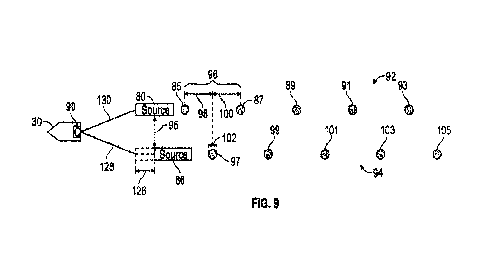
100761 FIG. 9 illustrates a third technique of seismic acquisition in a marine
environment utilizing the marine survey system 22 and/or the marine survey
system
31. As illustrated, the vessel 30 is towing two sources (i.e., source array 80
and
source array 86, although single seismic sources can be utilized in place of
either or
both of source array 80 and source array 86) so as to improve the operation
efficiency
(i.e., to increase data density and/or reduce operation run time and cost. In
the
illustrated embodiment, the vessel 30 includes the controller 90 (described
previously
in conjunction with FIGS. 5, 6, and 8) that operates generate and transmit a
control
signal to the source array 80 and/or the source array 86 to fire (i.e., for
one or more of
the seismic sources 78 and 84 therein to be fired).
[0077] In some embodiments, the controller 90 may include a processor, an
integrated
circuit, or other electronic processing circuitry capable of executing
computer-
executable code or instructions to implement the methods described herein. The
controller 90 can also include memory, storage, and/or other suitable articles
of
manufacture that can serve as media to store processor-executable code, data,
or the
like. These articles of manufacture may represent computer-readable media
(e.g., any
suitable form of memory or storage) that may store the processor-executable
code
29
CA 03149970 2022-3-2
WO 2021/050289
PCT/US2020/048318
used by the controller 90 processor 64 to perform the presently disclosed
techniques
with respect to FIG. 9.
100781 Generally, the controller 90 may execute a software application and/or
an
algorithm to generate one or more control signals to control the operation
(e.g., firing)
of the source array 80 and/or source array 86. In other embodiments,
individual
controllers 90 can each be dedicated to a respective source array 80 and
source array
86 to generate one or more control signals to control their respective
operation.
Furthermore, while only two source arrays 80 and 86 are illustrated, more than
two
sources or arrays may be utilized in conjunction with the techniques described
herein.
100791 As illustrated, the vessel 30 tows source array 80 along a shot line 92
and the
vessel 30 tows source array 86 along shot line 94. These shot lines 92 and 94
(and,
accordingly, the source array 80 and the source array 86) may be a distance 95
apart,
for example, 50 meters or another value. As additionally illustrated, source
array 86
may be horizontally offset by a distance 126 from the position of source array
80 (i.e.,
the source array 80 is be disposed at a first horizontal distance from the
vessel 30 and
the source array 86 is disposed at a second horizontal distance from the
vessel 30,
whereby a difference in the first horizontal distance and the second
horizontal
distance is distance 126). That is, the marine survey system 22 and/or the
marine
survey system 31 can be initially set up to have the source array 80 and the
source
array 86 offset from one another along the direction vessel 30 at a distance
126 to
generate asymmetric geometry of the marine survey system 22 and/or the marine
survey system 31. This distance 126 is be a fixed value, for example,
approximately 1
meter, approximately 2 meters, approximately 3 meters, or another value or the
distance 126 may approximately be between 1 meter and 4 meters, between 1
meter
CA 03149970 2022-3-2
WO 2021/050289
PCT/US2020/048318
and 3 meters, between 1 meter and 2 meters, between 2 meters and 3 meters,
between
2 meters and 4 meters, or another value. Alternatively, the distance 126 may
be
approximately 10%, 15%, 20%, 25%, 30%, 35%, 40%, 45%, 50%, 55%, 60%, 65%,
70%, 75%, 80%, 85%, 90%, 95% or 100% of distance 98 or approximately 10%,
15%, 20%, 25%, 30%, 35%, 40%, 45% or 50% of distance 96.
NON] Source array 80 fires shots (e.g., at shot point positions 85, 87, 89,
91, and 93)
each separated by a distance 96, for example, 25 meters. Likewise, source
array 86
fires shots (e.g., at shot point positions 97, 99, 101, 103, and 105) also
separated by a
distance 96, for example, 25 meters. Furthermore, source array 86 can fire
shots
1C1 between the shots of source array 80, for example, shot point position
97 at a distance
98 from shot point position 85 of the source array 80. However, while the shot
point
position 85 matches that described with respect to FIG. 6 (i.e., the
controller 90
generates and transmits control signals in a manner similar to that described
above
with respect to FIG. 6), the physical location of the source array 86 is
offset by the
distance 126 relative to the physical location of the source array 86 as
described in
FIG. 6. This offset alters the data generated by the acquisition technique in
FIG. 9
relative to the data generated in FIG. 6, as will be discussed below with
respect to
FIGS. 10 and 11. It should be noted that the offset (e.g., distance 126) may
be
positive or negative. It should also be noted that the offset is relative
position
between source array 80 array and source array 86, both source array 80 and
source
array 86 may be offset by any given distances, but their relative position is
what
matters on the data pattern as to be discussed below with respect to FIGS. 10
and 11.
100811 That is, the marine survey system 22 and/or the marine survey system 31
can
be initially set up to have the controller 90 generate shots at shot point
positions 97,
99, 101, 103, and 105, however, due to the distance 126 offset of source array
86, the
3
CA 03149970 2022-3-2
WO 2021/050289
PCT/US2020/048318
data collected will not be representative of data from a midpoint of distance
96. The
controller 90, for example, can control the distances 96, 98, and 100 and
distance 126
can be a predetermined distance that is generated via alteration of a length
of tether
128 relative to tether 130 and/or via alteration of the relative position of
sources
84/sub-arrays within the source array 86. For example, a winch or other
mechanism
may be employed to alter the length of tether 128_ The controller 90 (or
another
control mechanism) can operate to control the winch or other mechanism to
adjust the
length of the tether 128 to a fixed length. Alternatively, a tether 128 having
a length
that creates the distance 126 can instead be utilized. A fastener or other
connection
device may be disposed on or may be part of the source array 86 to couple the
tether
128 to the source array 86.
[0082] Furthermore, as will be discussed in greater detail with respect to
FIGS. 12
and 13, in the case of more than two seismic source arrays being towed by the
same
vessel 30, different shifts can be applied to each of the multiple source
arrays to
produce stronger incoherency of blending noise (i.e., the same shift in
distance and/or
time need not need be applied to each source array being towed to create more
randomness and incoherency of blending noise). The different shifts applied to
each
of the source arrays (e.g., shot point positions) may be considered as spatial
coding
that determines the pattern of blending noise. Every sail line/sequence may
share the
same spatial code or adopt different spatial codes for each sail
line/sequence.
Additionally, the controller 90 can generate the control signals in accordance
with
instructions loaded thereon or the control signals may be determined and
generated in
real time during the seismic survey by the controller 90.
[0083] In some embodiments, one or more of the shot point positions 85, 87,
89, 91,
and 93 and the shot point positions 97, 99, 101, 103, and 105 are additionally
32
CA 03149970 2022-3-2
WO 2021/050289
PCT/US2020/048318
dithered. That is, the controller 90 generates the control signals so that the
actual
position of one or more of the shot point positions 85, 87, 89, 91, 93, 97,
99, 101, 103,
and 105 are adjusted by a small amount. This amount may be a fraction of a
second,
for example, between approximately negative 250ms and positive 250ms or
another
value typically less than one second and may cause the actual position of one
or more
of the shot point positions 85, 87, 89, 91, 93, 97, 99, 101, 103, and 105 to
be moved at
a distance 102 (i.e., Ax) from the illustrated locations of the shot point
positions 85,
87, 89, 91, 93, 97, 99, 101, 103, and 105, whereby, for example, distance 102
is less
than the distances 96, 98, and 100. The dithering of the actual position of
one or more
of the shot point positions 85, 87, 89, 91, 93, 97, 99, 101, 103, and 105
described
above may be varied and the variance can be random, pseudo-random, or
according to
a pattern. Therefore, the overall shift illustrated in FIG. 9 includes both a
dithered
distance 102 (e.g., where the distance 102 is changing via a random, pseudo-
random,
or according to a pattern) and shifted distance 126 (e.g., where the distance
126 is
fixed, at least for a given shot line 94).
[0084] FIG. 10 illustrates an inline (along a shot line direction) section
view of
seismic data gathered (e.g., a common receiver gather) from the technique of
FIG. 8
or FIG. 9, or the combination of FIG. 8 and FIG. 9. Graph 129 corresponds to
seismic
data from shot line 92 and graph 131 corresponds to seismic data from shot
line 94.
Likewise, data signals 132 or noise correspond to shots from sources 78 while
data
signals 134 correspond to shots from sources 84. As described in conjunction
with
FIGS. 8 and 9, when performing source acquisitions of seismic data, the
seismic
source array 80 transmits a first signal at a first time (corresponding to
shot point
position 87, although not the first signal in the illustrated series) and the
seismic
source array 86 transmits a second signal at a second time (corresponding to
shot
33
CA 03149970 2022-3-2
WO 2021/050289
PCT/US2020/048318
point position 114 or shot point position 97 with a modified location of the
source
array 86 by the distance 126 and shot time dithering between, for example, -
500ms
and +500ms).
[0085] Thus, although not outputted at the same time, the first signal at the
first time
(corresponding to shot point position 87) and the second signal at the second
time
(corresponding to shot point position 97 or 114) may be transmitted relatively
close in
time such that there is a possibility of non-noise signal interference during
reception
of the first signal by the reception of the second signal. Thus, sometimes at
least a
portion of the second signal is received by the seismic receivers 33 and/or 36
when
the seismic receivers 33 and/or 36 are expecting to receive the first signal.
[0086] In this way, the data gathered corresponding to the first signal may
include
data corresponding to the second signal. As illustrated in FIG. 10, the
primary signal
data (the portion of the data signal 132 in graph 129) may correspond to data
gathered
corresponding to the primary signal of multiple seismic source excitations
(namely,
shots at shot point positions 85, 87, 89, 91, and 93) that travel through one
or more
features inside earth and return to a seismic receiver. Graph 129 also
includes
blending noise (the portion of data signal 134 in graph 129). However, in
contrast to
FIG. 7, the blending noise in graph 129 does not overlap with relevant signal
data 136
(i.e., weak signal data as a portion of data signal 132 that is relatively
weak compared
to the primary signal data).
[0087] Indeed, through the use of the shifting techniques described in
conjunction
with each of FIGS. 8 and 9, the blending noise has moved generally downwards
in
graph 129 and upwards in graph 131 (with a remainder portion above data signal
132
in graph 129 and above data signal 134 in graph 131) so that the blending
noise, while
still present, no longer conflicts with the relevant signal data 136.
Accordingly, the
34
CA 03149970 2022-3-2
WO 2021/050289
PCT/US2020/048318
relevant signal data 136 can be utilized in conjunction with the primary
signal data to
improve generated seismic models. Additionally, due to the removal of the
blending
noise from the location of the relevant signal data, deblending operations may
be
greatly improved, as the data to be deblended is simplified relative to the
data in FIG.
7.
100881 For example, the relevant signal data 136 can be utilized to remove
second
blending noise present in graph 131. Data gathered in graph 131 includes
second
primary signal data (e.g., the portion of the data signal 134 in graph 129
which is the
actual signal associated with the main response of the signal from the source
array 86
and multiple excitations toward one or more features or formations being
analyzed as
part of the seismic data collection, coherent signal) and second blending
noise (the
portion of data signal 132 in graph 131). The second blending noise may
overlap with
relevant signal data that is relatively weak compared to the second primary
signal
data However, the relevant signal data 136 can be applied to remove the second
blending noise more effectively in a deblending operation due to the 3D
continuity in
the crossline direction (perpendicular to shot line direction).
100891 For example, relevant signal data 136 at location 138 can be used in
the
deblending process to remove second blending noise at location 140 of the
second
blending noise. This will allow for a deblending operation that will be able
to extract
the relevant signal data that is relatively weak compared to the second
primary signal
data more easily and thoroughly, since the relevant second data at location
140
corresponds to the known relevant signal data 136 at location 138 (i.e. the
known
relevant signal data 136 at location 138 provides a reference for the second
blending
noise at location 140, as the relevant signal data 136 at location 138 and the
relevant
signal data at location 140 are supposed to be coherent while the shots are
sorted into
CA 03149970 2022-3-2
WO 2021/050289
PCT/US2020/048318
3D or higher dimension geometry). In a similar manner, the relevant signal
data in
graph 131 will provide a reference to effectively separate the blending noise
(the
portion of the data signal 134 in graph 129). Graphs 128 and 130 no longer
have the
same noise pattern (unlike graphs 106 and 108), which makes the deblending
much
easier once the data is sorted in 3D (or higher dimension).
100901 The coded interleaving techniques described in conjunction with each of
FIGS. 8 and 9 also allow us to control what portion of weak primary signals to
be
overlapped with the strong blending noise. It gives us the flexibility such
that the
important part of the signals (e.g. the data used to image subsurface
hydrocarbon
reservoir) will not be contaminated by blending noise or the contamination is
minimized.
100911 As previously noted, multiple source arrays may be utilized in
conjunction
with present techniques. For example, FIG. 11 illustrates a fourth technique
of
seismic acquisition in a marine environment utilizing the marine survey system
22
andior the marine survey system 31. As illustrated, the vessel 30 is towing
six
sources (i.e., source array 80 and source array 86, along with source array
142, source
array 144, source array 146, and source array 148 (although single seismic
sources
can be utilized in place of one or more of source array 80, source array 86,
source
array 142, source array 144, source array 146, and source array 148) so as to
improve
the operation efficiency (i.e., to increase data density and/or reduce
operation run time
and cost. In the illustrated embodiment, the vessel 30 includes a controller
90 that
operates to generate and transmit a control signal to the source array 80, the
source
array 86, the source array 142, the source array 144, the source array 146,
and/or the
source array 148 to fire (i.e., for one or more of the seismic sources 78 and
84, or
36
CA 03149970 2022-3-2
WO 2021/050289
PCT/US2020/048318
other associated seismic sources therein to be fired), as discussed above in
conjunction with FIG. 5.
[0092] Generally, the controller 90 may execute a software application and/or
an
algorithm to generate one or more control signals to control the operation
(e.g., firing)
of the source array 80, the source array 86, the source array 142, the source
array 144,
the source array 146, and/or the source array 148. In other embodiments,
individual
controllers 90 can each be dedicated to a respective source array 80, source
array 86,
source array 142, source array 144, source array 146, and source array 148 to
generate
one or more control signals to control their respective operation.
100931 As illustrated, the vessel 30 tows source array 80 along a shot line 92
and the
vessel 30 tows source array 86 along shot line 94. The vessel 30 also tows
source
array 142 along a shot line 150, source array 144 along a shot line 152,
source array
146 along shot line 154, and source array 148 along shot line 156. These shot
lines
92, 94, 150, 152, 154, and 156 (and, accordingly, the source array 80, the
source array
86, the source array 142, the source array 144, the source array 146, and/or
the source
array 148) may be a distance 95 apart, for example, 50 meters or another value
and
may be, for example, disposed in any azimuthal direction, not just in a
(horizontal)
direction along a sail line of the vessel 30. The source array 80, the source
array 86,
the source army 142, the source array 144, the source array 146, and the
source array
148 can fire shots in conjunction with the shot sequence 158. Additionally,
source
array 80 fires shots (e.g., at shot point positions 85, 87, 89, 91, and 93)
each separated
by a distance, for example, 25 meters. Likewise, source array 86 fires shots
(e.g., at
shot point positions 97, 99, 101, 103, and 105) also separated by a distance,
for
example, 25 meters. Similarly, each of the source array 142, the source array
144, the
37
CA 03149970 2022-3-2
WO 2021/050289
PCT/US2020/048318
source array 146, and the source array 148 fires shots (e.g., respectively at
shot point
positions 160, 162, 164, 166, and 168, shot point positions 170, 172, 174,
176, and
178, shot point positions 180, 182, 184, 186, and 188, and shot point
positions 190,
192, 194, 196, and 198).
100941 Furthermore, as illustrated via the shot sequence 158, each of the
source array
86, the source array 142, the source array 144, the source array 146, and the
source
array 148 fires shots between the shots of source array 80. Similarly, each of
the
source array 80, the source array 142, the source array 144, the source array
146, and
the source array 148 fires shots between the shots of source array 86. This
pattern
continues for the remaining source array 142, source array 144, source array
146, and
source array 148. The shots fires in conjunction with shot sequence 158 can
are
separated by a distance 200. In some embodiments, this distance 200 is the
total
distance between two shots from a source array along its shot path, for
example,
source array 80 along its shot line 92, divided by the total number of towed
source
arrays, for example, as illustrated, six source arrays 80, 86, 142, 144, 146,
and 148
(although other values and distances for distance 200 are contemplated).
100951 The controller 90, for example, can control the distances between shots
on
each of the shot lines 92, 94, 150, 152, 154, and 156 through issuance of
control
signals causing the source arrays 80, 86, 142, 144, 146, and 148 to fire at
desirable
and/or predetermined times associated with desired and/or predetermined values
for
distances between shots (of a shot line, for example, shot line 921) and for
distance
200. The controller 90 can generate the control signals in accordance with
instructions loaded thereon or the control signals may be determined and
generated in
real time during the seismic survey by the controller 90.
38
CA 03149970 2022-3-2
WO 2021/050289
PCT/US2020/048318
[0096] In some embodiments, one or more of the shot point positions 85, 87,
89, 91,
and 93,97, 99, 101, 103, and 105, 160, 162, 164, 166, and 168, 170, 172, 174,
176,
and 178, 180, 182, 184, 186, and 188, and 190, 192, 194, 196, and 198 are
additionally dithered. That is, the controller 90 generates the control
signals so that
the actual position of one or more of the shot point positions 85, 87, 89, 91,
93,97,
99, 101, 103, 105, 160, 162, 164, 166, 168, 170, 172, 174, 176, 178, 180, 182,
184,
186, 188, 190, 192, 194, 196, and 198 are adjusted by a small amount. This
amount
may be a fraction of a second, for example, between approximately negative
250ms
and positive 250ms or another value typically less than one second and may
cause the
actual position of one or more of the shot point positions 85, 87, 89, 91, 93,
97, 99,
101, 103, and 105 to be moved at a distance 102 (i.e., Ax) from the
illustrated
locations of the shot point positions 85, 87, 89, 91, 93, 97, 99, 101, 103,
105, 160,
162, 164, 166, 168, 170, 172, 174, 176, 178, 180, 182, 184, 186, 188, 190,
192, 194,
196, and 198, whereby, for example, distance 102 is less than the distance 200
and the
distances between shots (of a given shot line, for example, shot line 92). The
dithering of the actual position of one or more of the shot point positions
85, 87, 89,
91, 93, 97, 99, 101, 103, 105, 160, 162, 164, 166, 168, 170, 172, 174, 176,
178, 180,
182, 184, 186, 188, 190, 192, 194, 196, and 198 described above are varied and
the
variance can be random, pseudo-random, or according to a pattern.
[0097] FIG. 12 illustrates a fifth technique of seismic acquisition in a
marine
environment utilizing the marine survey system 22 and/or the marine survey
system
31. As illustrated, the vessel 30 is towing six sources (i.e., source array
80, source
arrays 86, source array 142, source array 144, source array 146, and source
array 148,
although single seismic sources can be utilized in place of one or more of
source
39
CA 03149970 2022-3-2
WO 2021/050289
PCT/US2020/048318
arrays 80, 86, 142, 144, 146, and 148) so as to improve the operation
efficiency (i.e.,
to increase data density and/or reduce operation run time and cost.
100981 In the illustrated embodiment, the vessel 30 includes a controller 90
that
operates to generate and transmit a control signal to the source array 80, the
source
array 86, the source array 142, the source array 144, the source array 146,
and/or the
source array 148 to fire (i.e., for one or more of the seismic sources 78 and
84, or
other associated seismic sources therein to be fired), as discussed above in
conjunction with FIG. 5. Generally, the controller 90 may execute a software
application and/or an algorithm to generate one or more control signals to
control the
operation (e.g., firing) of the source array 80, the source array 86, the
source array
142, the source array 144, the source array 146, and/or the source array 148.
In other
embodiments, individual controllers 90 can each be dedicated to a respective
source
array 80, source array 86, source array 142, source array 144, source array
146, and
source array 148 to generate one or more control signals to control their
respective
operation.
100991 As illustrated, the vessel 30 tows source array 80 along a shot line 92
and the
vessel 30 tows source array 86 along shot line 94. The vessel 30 also tows
source
array 142 along a shot line 150, source array 144 along a shot line 152,
source array
146 along shot line 154, and source array 148 along shot line 156. These shot
lines
92, 94, 150, 152, 154, and 156 (and, accordingly, the source array 80, the
source array
86, the source array 142, the source array 144, the source array 146, and/or
the source
array 148) may be a distance 95 apart, for example, 50 meters or another
value. The
source array 80, the source array 86, the source array 142, the source array
144, the
source array 146, and the source array 148 can fire shots in conjunction with
a shot
CA 03149970 2022-3-2
WO 2021/050289
PCT/US2020/048318
sequence. Source array 80 fires shots at shot point positions 204, 206, 208,
210, and
212, which are each adjusted at a distance 264 (i.e., Axi) relative to
respective shot
point positions 85, 87, 89, 91, and 93). Each of the shot point positions 204,
206, 208,
210, and 212 can be separated by a distance, for example, 25 meters. Likewise,
source array 86 fires shots (e.g., at shot point positions 214, 216, 218, 220,
and 222,
which are each adjusted at a distance 266 (i.e., Ax2) relative to respective
shot point
positions 97,99, 101, 103, and 105) also separated by a distance, for example,
25
meters. Similarly, each of the source array 142, the source array 144, the
source array
146, and the source array 148 fires shots respectively at shot point positions
224, 226,
228, 230, and 232 (each adjusted at a respective distance 268 (i.e., Ax3)
relative to
shot point positions 160, 162, 164, 166, and 168), shot point positions 234,
236, 238,
240, and 242 (each adjusted at a respective distance 270 (i.e., Ax4) relative
to shot
point positions 170, 172, 174, 176, and 178), shot point positions 244, 246,
248, 250,
and 252 (each adjusted at a respective distance 272 (i.e., Am) relative to
shot point
positions 180, 182, 184, 186, and 188), and shot point positions 254, 256,
258, 260,
and 262 (each adjusted at a respective distance 274 (i.e., dx6) relative to
shot point
positions 190, 192, 194, 196, and 198).
1001001 In this manner, each of the source array 86, the source array 142, the
source array 144, the source array 146, and the source array 148 fires shots
between
the shots of source array 80. However, the shot sequence may differ from the
shot
sequence 158 represented in FIG. 11_ For example, subsequent to a shot by the
source
array 80 at shot point position 206, a shot may be fired by the source array
144 at shot
point position 236. Thereafter, a shot may be fired by the source array 146 at
shot
point position 244. Subsequently, a shot may be fired by the source array 142
at shot
point position 224, a shot may be fired by the source array 148 at shot point
position
41
CA 03149970 2022-3-2
WO 2021/050289
PCT/US2020/048318
254, and a shot may be fired by the source array 86 at shot point position
214. This
shot sequence illustrates that distance 264 (i.e., AO, distance 266 (i.e.,
Ax2), distance
268 (i.e., Ax3), distance 270 (i.e., Ax4), distance 272 (i.e., Ax5), and
distance 274 (i.e.,
Ax6) can each be positive or negative. The shot sequence pattern used can
continue
for the remaining source arrays 86, 142, 144, 146, and 148. Additionally one
or more
of the distances 264, 266, 268, 270, 272, or 274 can be altered (i.e.,
variable or varied
based on a selection controlled, for example, via controller 90), which
results in a new
shot sequence pattern that can be repeated thereafter in a manner similar to
that
described above.
1001011 In other embodiments, one or more of the distances 264, 266, 268, 270,
272, or 274 can also be zero (i.e., unshifted). Likewise, one or more of the
distances
264, 266, 268, 270, 272, or 274 can be a fixed value, for example,
approximately 1
meter, approximately 2 meters, approximately 3 meters, or another value (in
either a
positive or negative direction with respect to the vessel 30, i.e., towards or
away from
the vessel 30) or the distance 124 may approximately be between 1 meter and 4
meters, between 1 meter and 3 meters, between 1 meter and 2 meters, between 2
meters and 3 meters, between 2 meters and 4 meters, or another value (in
either a
positive or negative direction with respect to the vessel 30, i.e., towards or
away from
the vessel 30). Alternatively, the distance 124 may be approximately 10%, 15%,
20%, 25%, 30%, 35%, 40%, 45%, 50%, 55%, 60%, 65%, 70%, 75%, 80%, 85%,
90%, 95% or 100% of the distance between shots of a shot line, for example,
shot line
92 or approximately 10%, 15%, 20%, 25%, 30%, 35%, 40%, 45%, or 50% of the
distance between shots of a shot line, for example, shot line 92.
42
CA 03149970 2022-3-2
WO 2021/050289
PCT/US2020/048318
[00102] As previously noted, the controller 90, for example, can control the
distances 264, 266, 268, 270, 272, and 274 through issuance of control signals
causing
the source arrays 80, 86, 142, 144, 146, and 148 to fire at desirable and/or
predetermined times associated with desired and/or predetermined values for
distances 264, 266, 268, 270, 272, and 274. The controller 90 can generate the
control signals in accordance with instructions loaded thereon or the control
signals
may be determined and generated in real time during the seismic survey by the
controller 90. Indeed, as illustrated in FIG. 12, the controller 90 generates
control
signals that alter the timing of the shot point positions of the shot lines
92, 94, 150,
152, 154, and 156 relative to the timing of the shot point positions 85, 87,
89, 91, 93,
97, 99, 101, 103, 105, 160, 162, 164, 166, 168, 170, 172, 174, 176, 178, 180,
182,
184, 186, 188, 190, 192, 194, 196, and 198 of FIG. 11 and additionally
illustrated for
reference only in FIG. 12. In this marmer, the controller 90 causes, for
example, the
shift in distances 264, 266, 268, 270, 272, and 274 for each of the shot point
positions
204, 214, 224, 234, 244, and 254)_ The shift in distances 264, 266, 268, 270,
272, and
274 of the actual position of one or more of the shot point positions 204,
214, 224,
234, 244, and 254 described above may be varied and the variance can be
random,
pseudo-random, or according to a pattern; however, once shifted, the distances
264,
266, 268, 270, 272, and 274 remain fixed at least for a given shot line 94.
[00103] In some embodiments, one or more of the shot point positions 204, 206,
208, 210, and 212, shot point positions 214, 216, 218, 220, and 222, shot
point
positions 224, 226, 228, 230, and 232, shot point positions 234, 236, 238,
240, and
242, shot point positions 244, 246, 248, 250, and 252, and shot point
positions 254,
256, 258, 260, and 262 are additionally dithered. That is, the controller 90
generates
the control signals so that the actual position of one or more of the shot
point positions
43
CA 03149970 2022-3-2
WO 2021/050289
PCT/US2020/048318
204, 206, 208, 210, 212, 214, 216, 218, 220, 222, 224, 226, 228, 230, 232,
234, 236,
238, 240, 242, 244, 246, 248, 250, 252, 254, 256, 258, 260, and 262 are
adjusted by a
small amount. This amount may be a fraction of a second, for example, between
approximately negative 250ms and positive 250ms or another value typically
less than
one second and may cause the actual position of one or more of the shot point
positions 204, 206, 208, 210, 212, 214, 216, 218, 220, 222, 224, 226, 228,
230, 232,
234, 236, 238, 240, 242, 244, 246, 248, 250, 252, 254, 256, 258, 260, and 262
to be
moved at a distance 102 (i.e., Ax.) from the illustrated locations of the shot
point
positions 204, 206, 208, 210, 212, 214, 216, 218, 220, 222, 224, 226, 228,
230, 232,
234, 236, 238, 240, 242, 244, 246, 248, 250, 252, 254, 256, 258, 260, and 262
whereby, for example, distance 102 is less than the distances 264, 266, 268,
270, 272,
and 274.
1001.041 The dithering of the actual position of one or more of the shot point
positions 204, 206, 208, 210, 212, 214, 216, 218, 220, 222, 224, 226, 228,
230, 232,
234, 236, 238, 240, 242, 244, 246, 248, 250, 252, 254, 256, 258, 260, and 262
described above may be varied and the variance can be random, pseudo-random,
or
according to a pattern. Therefore, the overall shift illustrated in FIG. 12
includes both
a dithered distance 102 (e.g., where the distance 102 is changing via a
random,
pseudo-random, or according to a pattern) and shifted distances 264, 266, 268,
270,
272, and 274 (e.g., where the distances 264, 266, 268, 270, 272, and 274 are
fixed, at
least for a given shot line, for example, shot line 94), and the overall shift
is no longer
fixed for a given line when the dithered distance is included. An equivalent
implementation of the concept is to shift the center of the dithered shot time
by a fixed
amount. For example, assuming it takes the source boat 30 time t_swft to
travel, for
example, distance 124, dithering of shot time between negative 250ms and
positive
44
CA 03149970 2022-3-2
WO 2021/050289
PCT/US2020/048318
250ms and fixed shot point position shift of distance 124 may be replaced by a
dithering between -250ms + t .s-hift and 250ms + t without explicit fixed
shot point
position shift. It should be noted that the shot position shift may applied to
shot lines
92, 94, 150, 152, 154, and 156 with different distances applied respectively.
This
offset alters the data generated by the acquisition technique in FIG. 12
relative to the
data generated in FIG. 11, as was previously discussed with respect to FIG.
10_
[00105] FIG. 13 illustrates a sixth technique of seismic acquisition in a
marine
environment utilizing the marine survey system 22 and/or the marine survey
system
31. As illustrated, the vessel 30 is towing six sources (i.e., source array
80, source
arrays 86, source array 142, source array 144, source array 146, and source
array 148,
although single seismic sources can be utilized in place of one or more of
source
arrays 80, 86, 142, 144, 146, and 148) so as to improve the operation
efficiency (i.e.,
to increase data density and/or reduce operation run time and cost.
[00106] In the illustrated embodiment, the vessel 30 includes a controller 90
that
operates to generate and transmit a control signal to the source array 80, the
source
array 86, the source array 142, the source array 144, the source array 146,
and/or the
source array 148 to fire (i.e., for one or more of the seismic sources 78 and
84, or
other associated seismic sources therein to be fired), as discussed above in
conjunction with FIG. 5. Generally, the controller 90 may execute a software
application and/or an algorithm to generate one or more control signals to
control the
operation (e.g., firing) of the source array 80, the source array 86, the
source array
142, the source array 144, the source array 146, and/or the source array 148.
In other
embodiments, individual controllers 90 can each be dedicated to a respective
source
array 80, source array 86, source array 142, source array 144, source array
146, and
CA 03149970 2022-3-2
WO 2021/050289
PCT/US2020/048318
source array 148 to generate one or more control signals to control their
respective
operation.
[00107] As illustrated, the vessel 30 tows source array 80 along a shot line
92 and
the vessel 30 tows source array 86 along shot line 94. The vessel 30 also tows
source
array 142 along a shot line 150, source array 144 along a shot line 152,
source array
146 along shot line 154, and source array 148 along shot line 156. These shot
lines
92, 94, 150, 152, 154, and 156 (and, accordingly, the source array 80, the
source array
86, the source array 142, the source array 144, the source array 146, and/or
the source
array 148) may be a distance 95 apart, for example, 50 meters or another
value. The
source array 80, the source array 86, the source array 142, the source array
144, the
source array 146, and the source array 148 can fire shots in conjunction with
a shot
sequence.
[00108] As additionally illustrated, source array 80 may be horizontally
offset by a
distance 276 (i.e., Axr) from the position of source array 80 in FIGS. 11 and
12.
Likewise, source array 86 may be horizontally offset by a distance 278 (i.e.,
Am.)
from the position of source array 86 in FIGS. 11 and 12. Similarly, source
array 142
may be horizontally offset by a distance 280 (Le., Ax3') from the position of
source
array 142 in FIGS. 11 and 12, source array 144 may be horizontally offset by a
distance 282 (i.e., Am.) from the position of source array 144 in FIGS. 11 and
12,
source array 146 may be horizontally offset by a distance 284 (i.e., Ax5')from
the
position of source array 146 in FIGS. 11 and 12, and source array 148 may be
horizontally offset by a distance 286 (i.e., Ax.6.) from the position of
source array 148
in FIGS. 11 and 12.
46
CA 03149970 2022-3-2
WO 2021/050289
PCT/US2020/048318
[00109] That is, the marine survey system 22 and/or the marine survey system
31
can be initially set up to have the source arrays 80, 86, 142, 144, 146, and
148 offset
from one another along the direction of sail of the vessel 30 and/or, for
example,
offset relative to a common distance along the direction of sail of the vessel
30.
Likewise, one or more of the source arrays 80, 86, 142, 144, 146, and 148 may
not be
offset, for example, relative to their position in FIGS. 11 and 12 and/or one
or more of
the source arrays 80, 86, 142, 144, 146, and 148 may be offset by a common
value
from the vessel 30. These offsets, represented in FIG. 13 by distances 276,
278, 280,
282, 284, and 286, operate to generate asymmetric geometry of the marine
survey
system 22 and/or the marine survey system 31. These distances 276, 278, 280,
282,
284, and 286 may be fixed values, for example, approximately 1 meter,
approximately
2 meters, approximately 3 meters, or another value (in either a positive or
negative
direction with respect to the vessel 30, i.e., towards or away from the vessel
30) or the
distances 276, 278, 280, 282, 284, and 286 may approximately be between 1
meter
and 4 meters, between 1 meter and 3 meters, between 1 meter and 2 meters,
between
2 meters and 3 meters, between 2 meters and 4 meters, or another value (in
either a
positive or negative direction with respect to the vessel 30, i.e., towards or
away from
the vessel 30). Alternatively, the distances 276, 278, 280, 282, 284, and 286
may be
approximately 10%, 15%, 20%, 25%, 30%, 35%, 40%, 45%, 50%, 55%, 60%, 65%,
70%, 75%, 80%, 85%, 90%, 95% or 100% of a distance between shots of a shot
line,
for example, shot line 92 or approximately 10%, 15%, 20%, 25%, 30%, 35%, 40%,
45% or 50% of the distance between shots of a shot line, for example, shot
line 92.
[00110] Similar to the discussion of FIG. 11 above, the source array 80, the
source
array 86, the source array 142, the source array 144, the source array 146,
and the
source array 148 can fire shots. Source array 80 fires shots at shot point
positions 85,
47
CA 03149970 2022-3-2
WO 2021/050289
PCT/US2020/048318
87, 89,91, and 93 and source array 86 fires shots at shot point positions 97,
99, 101,
103, and 105. Likewise, the source array 142, the source array 144, the source
array
146, and the source array 148 fires shots, respectively, at shot point
positions 160,
162, 164, 166, and 168, shot point positions 170, 172, 174, 176, and 178, shot
point
positions 180, 182, 184, 186, and 188, and shot point positions 190, 192, 194,
196,
and 198).
1001111 However, due to the offset of the position of the source arrays 80,
86, 142,
144, 146, and 148, as illustrated in FIG. 13, while the shot point positions
85, 87, 89,
91, 93,97, 99, 101, 103, 105, 160, 162, 164, 166, 168, 170, 172, 174, 176,
178, 180,
182, 184, 186, 188, 190, 192, 194, 196, and 198 matches that described with
respect
to FIG. 11 (i.e., the controller 90 generates and transmits control signals in
a manner
similar to that described above with respect to FIG. 11), the physical
location of the
source arrays 80, 86, 142, 144, 146, and 148 in FIG. 13 are offset,
respectively, by the
distances 276, 278, 280, 282, 284, and 286 relative to the physical location
of the
source arrays 80, 86, 142, 144, 146, and 148 as described in FIG. 11. This
offset
alters the data generated by the acquisition technique in FIG. 13 relative to
the data
generated in FIG. 11, as was previously discussed with respect to FIG. 10.
1001121 The marine survey system 22 and/or the marine survey system 31 can be
initially set up to have the controller 90 generate shots at shot point
positions 85, 87,
89, 91,93, 97, 99, 101, 103, 105, 160, 162, 164, 166, 168, 170, 172, 174, 176,
178,
180, 182, 184, 186, 188, 190, 192, 194, 196, and 198, however, due to the
offsets at
distances 276, 278, 280, 282, 284, and 286 of source arrays 80, 86, 142, 144,
146, and
148, the data collected will not be representative of data, for example, from
a
midpoint of distance 96_ The controller 90, for example, can control the
distances
276, 278, 280, 282, 284, and 286 as being one or more predetermined distances
that is
48
CA 03149970 2022-3-2
WO 2021/050289
PCT/US2020/048318
generated via alteration of a length of tether 128, tether 130, tether 288,
tether 290,
tether 292, and tether 294, and/or via alteration of the relative position of
sources 78,
84/sub-arrays within the source arrays 80, 86, 142, 144, 146, and 148. For
example, a
winch or other mechanism may be employed to alter the length of tethers 128,
130,
288, 290, 292, and/or 294. The controller 90 (or another control mechanism)
can
operate to control the winch or other mechanism to adjust the length of the
tethers
128, 130, 288, 290, 292, and/or 294 to one or more respective fixed lengths.
Alternatively, tethers 128, 130, 288, 290, 292, and 294 having one or more
fixed
lengths can instead be utilized to create the distances 276, 278, 280, 282,
284, and
286. A fastener or other connection device may be disposed on or may be part
of the
source arrays 80, 86, 142, 144, 146, and 148 to couple the tethers 128, 130,
288, 290,
292, and 294 to their respective source arrays 80, 86, 142, 144, 146, and 148.
1001131 As illustrated in FIG. 13, different shifts are applied to each of the
multiple
source arrays 80, 86, 142, 144, 146, and 148 to produce stronger incoherency
of
blending noise (i.e., the same shift in distance and/or time need not need be
applied to
each source array 80, 86, 142, 144, 146, and 148 being towed to create more
randomness and incoherency of blending noise). The different shifts applied to
each
of the source arrays 80, 86, 142, 144, 146, and 148 (e.g., shot point
positions) may be
considered as spatial coding that determines the pattern of blending noise.
Every sail
line/sequence may share the same spatial code or adopt different spatial codes
for
each sail line/sequence. Additionally, the controller 90 can generate the
control
signals in accordance with instructions loaded thereon or the control signals
may be
determined and generated in real time during the seismic survey by the
controller 90.
1001141 In some embodiments, one or more of the shot point positions 85, 87,
89,
91, 93, 97, 99, 101, 103, 105, 160, 162, 164, 166, 168, 170, 172, 174, 176,
178, 180,
49
CA 03149970 2022-3-2
WO 2021/050289
PCT/US2020/048318
182, 184, 186, 188, 190, 192, 194, 196, and 198 are additionally dithered.
That is, the
controller 90 generates the control signals so that the actual position of one
or more of
the shot point positions 85, 87, 89, 91, 93, 97, 99, 101, 103, 105, 160, 162,
164, 166,
168, 170, 172, 174, 176, 178, 180, 182, 184, 186, 188, 190, 192, 194, 196, and
198
are adjusted by a small amount. This amount may be a fraction of a second, for
example, between approximately negative 250ms and positive 250ms or another
value
typically less than one second and may cause the actual position of one or
more of the
shot point positions 85, 87, 89, 91, 93, 97, 99, 101, 103, 105, 160, 162, 164,
166, 168,
170, 172, 174, 176, 178, 180, 182, 184, 186, 188, 190, 192, 194, 196, and 198
to be
moved at a distance 102 (i.e., Ax) from the illustrated locations of the shot
point
positions 85, 87, 89, 91, 93, 97,99, 101, 103, 105, 160, 162, 164, 166, 168,
170, 172,
174, 176, 178, 180, 182, 184, 186, 188, 190, 192, 194, 196, and 198, whereby,
for
example, distance 102 is less than the distances 276, 278, 280, 282, 284, and
286.
The dithering of the actual position of one or more of the shot point
positions 85, 87,
89, 91,93, 97, 99, 101, 103, 105, 160, 162, 164, 166, 168, 170, 172, 174, 176,
178,
180, 182, 184, 186, 188, 190, 192, 194, 196, and 198 described above may be
varied
and the variance can be random, pseudo-random, or according to a pattern.
Therefore, the overall shift illustrated in FIG. 13 includes both a dithered
distance 102
(e.g., where the distance 102 is changing via a random, pseudo-random, or
according
to a pattern) and a shifted distance 276, 278, 280, 282, 284, and 286 (e.g.,
where the
distance 126 is fixed, at least for a given shot line, for example, shot line
94).
1001151 Technical effects of this disclosure include systems and methods for
alteration of seismic acquisitions that result in the variation of the
blending noise
pattern along different shot lines (i.e_ greater incoherency of blending
noise) and the
ability to control the section of seismic data to be contaminated by blending
noise.
CA 03149970 2022-3-2
WO 2021/050289
PCT/US2020/048318
The acquisition techniques allow for improvements in a deblending process due
to the
variation of noise pattern and increased incoherency of the blending noise.
The
techniques include a shift in the physical location of a source relative to
another
source or a shift in the physical shot point locations of a shot line relative
to another
shot line or a shift in time that a source is fired relative to firing of
another source and
a random dithering applied on shot time. Resulting gathers after deblending
may be
relatively dean gathers (in comparison to a gather that was not generated via,
the
disclosed techniques) that may be used both for imaging, prestack analysis
such as
AVO (Amplitude vs, Offset) analysis, and velocity-model building. for example,
by
Full-Waveform inversion (FW1). Thus, these recovery and processing operations
described herein may cause improved data inputs into seismic image generators.
When data inputs into the seismic image generators are improved, the resulting
seismic image may also improve, causing an improvement of a representation of
hydrocarbons in a subsurface region of Earth or of subsurface drilling
hazards.
1001001 The specific embodiments described above have been shown by way of
example, and it should be understood that these embodiments may be susceptible
to
various modifications and alternative forms. It should be further understood
that the
claims are not intended to be limited to the particular forms disclosed, but
rather to
cover all modifications, equivalents, and alternatives falling within the
spirit and scope
of this disclosure.
1001011 The techniques presented and claimed herein are
referenced and applied to
material objects and concrete examples of a practical nature that demonstrably
improve
the present technical field and, as such, are not abstract, intangible or
purely theoretical.
Further, if any claims appended to the end of this specification contain one
or more
51
CA 03149970 2022-3-2
WO 2021/050289
PCT/US2020/048318
elements designated as "means for [perform]ing [a function]..." or "step for
[performling [a function].....," it is intended that such elements are to be
interpreted
under 35 U.S.C. 112(0. However, for any claims containing elements designated
in
any other manner, it is intended that such elements are not to be interpreted
under 35
U.S.C. 112(f).
52
CA 03149970 2022-3-2