Note: Descriptions are shown in the official language in which they were submitted.
CA 03174472 2022-09-01
WO 2021/178622
PCT/US2021/020805
SYSTEMS AND METHODS FOR PEST PRESSURE
HEAT MAPS
CROSS REFERENCE TO RELATED APPLICATIONS
[0001] This application claims priority to U.S. provisional
application serial No. 62/984881, filed March 4, 2020, U.S. provisional
application
serial No. 62/984885, filed March 4, 2020, U.S. patent application serial No.
17/081,263, filed October 27, 2020, and U.S. patent application No. U.S.
patent
application serial No. 17/081,361, filed October 27, 2020.
BACKGROUND
[0002] The present application relates generally to a
technology that
may be used to assist in monitoring pt pressure, and more particularly, to
network-
based systems and methods for generating and display pest pressure heat maps.
[0003] Due to the world's increasing population and
decreasing
amount of arable land, there is a desire for methods and systems to increase
the
productivity of agricultural crops. At least one factor that impacts the
productivity of
agricultural crops is pest pressure.
[0004] Accordingly, systems and methods have been developed
to
monitor and analyze pest pressure. For example, in at least some known
systems, a
plurality of insect traps are placed in a field of interest. To monitor the
pest pressure in
the field of interest, the traps are inspected regularly to count the number
of pests in
each trap. Based on the number of pests in each trap, a pest pressure level
for the field
of interest can be determined.
[0005] The number of pests monitored in each trap may also
be used
to predict future pest pressures. However, pest pressure is a relatively
complex
phenomenon that is governed by several factors. Thus, accurately predicting
future pest
1
Date Recue/Date Received 2022-09-01
CA 03174472 2022-09-01
WO 2021/178622
PCT/US2021/020805
pressures based primarily on trap counts may be relatively inaccurate.
Further, at least
some known systems for pest pressure monitoring are focused at an individual
farm
level, resulting in limited visualizations and significant time lag in data
collections. In
addition, at least some known systems for predicting future pest pressure rely
on static
logic (e.g., fixed phenology models and/or decision trees), and are
accordingly limited
in their ability to accurately predict future pest pressure. US 2017/041407 Al
describes
a data receiving module receives sampled agricultural-related data associated
with a
given geographic area. US 2008/312942 Al describes a method and system for
displaying predictions on a spatial map that includes using a data analyzer
for analyzing
heterogeneous data having a spatial component to find utilizable data and
using
machine learning to automatically extract relationships from the utilizable
data. EP
3482630 Al describes a method for performing a pest forecast. WO 2012/054397
Al
describes illustrative embodiments of integrated pest management (IPM) systems
and
electronic insect monitoring devices (EIMDs). WO 2004/i 10142 Al describes an
integrated method and system for preventing and solving problems relating to
pests of
any kind on a site, in a building, in a process, installation or in an area.
US 2015/025926
Al describes a computer system for managing agricultural sales involving a
salesperson
and a first grower.
[0006] Accordingly, it would be desirable to provide a system
that
captures and intelligently analyzes a plurality of different types of
information to
quickly and accurately predict future pest pressures. Further, it would be
desirable to
present predicted future pest pressures to assist users in perfOrming the
technical task
of monitoring pest pressure, and optionally controlling a pest trap system
and/or a pest
treatment system.
BRIEF DESCRIPTION
[0007] In one aspect, a heat map generation computing device is
provided. The heat map generation computing device includes a memory and a
processor communicatively coupled to the memory. The processor is programmed
to
receive trap data for a plurality of pest traps in a geographic location, the
trap data
2
CA 03174472 2022-09-01
WO 2021/178622
PCT/US2021/020805
including current and historical pest pressure values at each of the plurality
ofpest traps,
receive weather data for the geographic location, receive image data for the
geographic
location, and apply a machine learning algorithm to the trap data, the weather
data, and.
the image data to generate predicted future pest pressure values at each of
the plurality
of pest traps. The processor is further programmed to generate a fast heat map
for a
first point in time and a second heat map for a second point in time, the
second heat
map generated using the predicted future pest pressure values, the first and
second heat
maps each generated by plotting a plurality of nodes on a map of the
geographic
location, each node corresponding to one of the plurality of pest traps, each
node having
a color that represents the pest pressure value for the corresponding pest
trap at the
associated point in time, and coloring at least som.e remaining portions of
the map of
the geographic location to generate a continuous map of pest pressure values
for the
geographic location by interpolating between pest pressure values associated
with the
plurality of nodes at the associated point in time. The processor is further
programmed
to transmit the first and second heat maps to a mobile computing device to
cause a user
interface on the mobile computing device to display a time lapse heat map that
dynamically transitions between the first heat map and the second heat map
over time,
the user interface implemented via an application installed on the mobile
computing
device.
[0008] In another aspect, method for generating heat maps is
provided. The method is implemented using a heat map generation computing
device
including a memory communicatively coupled to a processor. The method includes
receiving trap data for a plurality of pest traps in a geographic location,
the trap data
including current and historical pest pressure values at each of the plurality
ofpest traps,
receiving weather data for the geographic location, receiving image data for
the
geographic location, and applying a machine learning algorithm to the trap
data, the
weather data, and the image data to generate predicted future pest pressure
values at
each of the plurality of pest traps. The method further includes generating a
first heat
m.ap for a first point in time and a second heat map for a second point in
time, the second
heat map generated using the predicted future pest pressure values, the first
and second
3
CA 03174472 2022-09-01
WO 2021/178622
PCT/US2021/020805
heat maps each generated by plotting a plurality of nodes on a map of the
geographic
location, each node corresponding to one of the plurality of pest traps, each
node having
a color that represents the pest pressure value for the corresponding pest
trap at the
associated point in time, and coloring at least some remaining portions of the
map of
the geographic location to generate a continuous map of pest pressure values
for the
geographic location by interpolating between pest pressure values associated
with the
plurality of nodes at the associated point in time. The method further
includes
transmitting the first and second heat maps to a mobile computing device to
cause a
user interface on the mobile computing device to display a time lapse heat map
that
dynamically transitions between the first heat map and the second heat map
over time,
the user interface implemented via an application installed on the mobile
computing
device.
[0009] In yet another aspect, a computer-readable storage
medium
having computer-executable instructions embodied thereon is provided. When
executed by a heat map generation computing device including at least one
processor
in communication with a memory, the computer-readable instructions cause the
heat
map generation computing device to receive trap data for a plurality of pest
traps in a
geographic location, the trap data including current and historical pest
pressure values
at each of the plurality of pest traps, receive weather data for the
geographic location,
receive image data for the geographic location, and apply a machine learning
algorithm
to the trap data, the weather data, and the image data to generate predicted
fitture pest
pressure values at each of the plurality of pest traps. The instructions
further cause the
heat map generation computing device to generate a first heat map for a first
point in
time and a second heat map for a second point in time, the second heat map
generated
using the predicted future pest pressure values, the first and second heat
maps each
generated by plotting a plurality of nodes on a map of the geographic
location, each
node corresponding to one of the plurality of pest traps, each node having a
color that
represents the pest pressure value for the corresponding pest trap at the
associated point
in time, and coloring at least some remaining portions of the map of the
geographic
location to generate a continuous map of pest pressure values for the
geographic
4
CA 03174472 2022-09-01
WO 2021/178622 PCT/U
S2021/020805
location by interpolating between pest pressure values associated with the
plurality of
nodes at the associated point in time. The instructions further cause the heat
map
generation computing device to transmit the first and second heat maps to a
mobile
computing device to cause a user interface on the mobile computing device to
display
a time lapse heat map that dynamically transitions between the first heat map
and the
second heat map over time, the user interface implemented via an application
installed
on the mobile computing device. It may be appreciated that the disclosed
technique
allows providing predicted future pest pressures to assist users in performing
the
technical task of monitoring pest pressure, and optionally controlling a pest
trap system
and/or a pest treatment system. It may be appreciated that the disclosed
technique
allows to provide a dynamic internal state of a pest pressure monitoring
system e.g. at
a future point in time.
BRIEF DESCRIPTION OF THE DRAWINGS
[0010] FIGS. 1 ¨10 show example embodiments of the methods and
systems described herein.
[0011] FIG. 1 is a block diagram of a computer system used in
predicting pest pressures in accordance with one embodiment of the present
disclosure.
[0012] FIG. 2 is a block diagram illustrating data flow through
the
system shown in FIG. 1.
[0013] FIG. 3 illustrates an example configuration of a server
system such as the pest pressure prediction computing device of FIGS. 1 and 2.
[0014] FIG. 4 illustrates an example configuration of a client
system
shown in FIGS. 1 and 2.
[0015] FIG. 5 is a flow diagram of an example method for
generating pest pressure data using the system shown in FIG. I.
CA 03174472 2022-09-01
WO 2021/178622
PCT/US2021/020805
[0016] FIG. 6 is a flow diagram of an example method for
generating heat maps using the system shown in FIG. I.
[0017] FIGS. 7-12 are example screenshots of a user interface
that
may be generated using the system shown in FIG. 1
[(X)18] Although specific features of various embodiments may be
shown in some drawings and not in others, this is for convenience only. Any
feature of
any drawing may be referenced and/or claimed in combination with any feature
of any
other drawing.
DETAILED DESCRIPTION
[0019] The systems and methods described herein are directed to
computer-implemented systems for generating and displaying pest pressure heat
maps.
A heat map generation computing device receives trap data for a plurality of
pest traps
in a geographic location, receives weather data for the geographic location,
receives
image data for the geographic location, and applies a machine learning
algorithm to the
trap data, the weather data, and the image data to generate predicted future
pest pressure
values at each of the plurality of pest traps. The heat map generation
computing device
generates a first heat map for a first point in time and a second heat map for
a second
point in time, the second heat map generated using the predicted future pest
pressure
values, the first and second heat maps each generated by plotting a plurality
of nodes
on a map of the geographic location, each node corresponding to one of the
plurality of
pest traps, each node having a color that represents the pest pressure value
for the
corresponding pest trap at the associated point in time, and coloring at least
some
remaining portions of the map of the geographic location to generate a
continuous map
of pest pressure values for the geographic location by interpolating between
pest
pressure values associated with the plurality of nodes at the associated point
in time.
The heat map generation computing device transmits the first and second heat
maps to
a mobile computing device to cause a user interface on the mobile computing
device to
display a time lapse heat map that dynamically transitions between the first
heat map
6
CA 03174472 2022-09-01
WO 2021/178622
PCT/US2021/020805
and the second heat map over time, the user interface implemented via an
application
installed on the mobile computing device.
[0020] The systems and methods described herein facilitate
accurately predicting pest pressure at one or more geographic locations. As
used herein,
a 'geographic location' generally refers to an agriculturally relevant
geographic
location (e.g., a location including one or more fields and/or farms for
producing crops).
Further, as used here, 'pest pressure' refers to a qualitative and/or
quantitative
assessment of the abundance of pests present at a particular location. For
example, a
high pest pressure indicates that a relatively large abundance (e.g., as
compared to an
expected abundance) of pests are present at the location. In contrast, a low
pest pressure
indicates that a relatively low abundance of pests are present at the
location. In at least
some of the embodiments described herein, pest pressure is analyzed for
agricultural
purposes. That is, pest pressure is monitored and predicted for one or more
fields.
However, those of skill in the art will appreciate that the systems and
methods described
herein may be used to analyze pest pressure in any suitable environment.
[0021] As used herein, the term 'pest' refers to an organism
whose
presence is generally undesirable at the particular geographic location, in
particular an
agriculturally relevant geographic location. For example, for implementations
that
analyze pest pressure for one or more fields, pests may include insects that
have a
propensity to damage crops in those fields. However, those of skill in the art
will
appreciate that the systems and methods described herein may be used to
analyze pest
pressure for other types of pests. For example, in some embodiments, pest
pressure
may be analyzed for fungi, weeds, and/or diseases. The systems and methods
described
herein refer to 'pest traps' and 'trap data'. As used herein, "pest traps' may
refer to any
device capable of containing and/or monitoring presence of a pest of interest,
and 'trap
data' may refer to data gathered using such a device. For example, for
insects, the 'pest
trap' may be a conventional containment device that secures the pest.
Alternatively,
for fungi, weeds, or diseases, the 'pest trap' may refer to any device capable
of
monitoring presence and/or levels of the fungi, weeds, and/or diseases. For
example,
in embodiments where the 'pest' is one or more species of fungi, the 'pest
trap' may
7
CA 03174472 2022-09-01
WO 2021/178622
PCT/US2021/020805
refer to a sensing device capable of quantitatively measuring a level of
spores associated
with the one or more species of fungi in the ambient environment around the
sensing
device. In one embodiment, the 'pest' is a type of insect or multiple types of
insects,
and the terms 'pest trap' and 'pest traps' refer to 'insect trap' and 'insect
traps',
respectively.
[0022] The following detailed description of the embodiments of
the
disclosure refers to the accompanying drawings. The same reference numbers in
different drawings may identify the same or similar elements. Also, the
following
detailed description does not limit the claims.
[0023] Described herein are computer systems such as pest
pressure
prediction computing devices. As described herein, all such computer systems
include
a processor and a memory. However, any processor in a computer device referred
to
herein may also refer to one or more processors wherein the processor may be
in one
computing device or a plurality of computing devices acting in parallel.
Additionally,
any memory in a computer device referred to herein may also refer to one or
more
memories wherein the memories may be in one computing device or a plurality of
computing devices acting in parallel.
[0024] As used herein, a processor may include any programmable
system including systems using micro-controllers, reduced instruction set
circuits
(RISC), application specific integrated circuits (ASICs), logic circuits, and
any other
circuit or processor capable of executing the functions described herein. The
above
examples are example only, and are thus not intended to limit in any way the
definition
and/or meaning of the term "processor."
[0025] As used herein, the term "database" may refer to either
a
body of data, a relational database management system (RDBMS), or to both. As
used
herein, a database may include any collection of data including hierarchical
databases,
relational databases, flat file databases, object-relational databases, object-
oriented
databases, and any other structured collection of records or data that is
stored in a
computer system. The above examples are example only, and thus are not
intended to
8
CA 03174472 2022-09-01
WO 2021/178622
PCT/US2021/020805
limit in any way the definition and/or meaning of the term database. Examples
of
RDBMS's include, but are not limited to including, Oracle Database, MySQL,
IBM
DB2, Microsoft SQL Server, Sybase , and PostgreSQL. However, any database may
be used that enables the systems and methods described herein. (Oracle is a
registered
trademark of Oracle Corporation, Redwood Shores, California; IBM is a
registered
trademark of International Business Machines Corporation, Armonk, New York;
Microsoft is a registered trademark of Microsoft Corporation, Redmond,
Washington;
and Sybase is a registered trademark of Sybase, Dublin, California.)
[0026] In one embodiment, a computer program is provided, and
the
program is embodied on a computer readable medium. In an example embodiment,
the
system is executed on a single computer system, without requiring a connection
to a
sever computer. In a further embodiment, the system is being run in a Windows
environment (Windows is a registered trademark of Microsoft Corporation,
Redmond,
Washington). In yet another embodiment, the system is run on a mainframe
environment and a UNIX server environment (UNIX is a registered trademark of
X/Open Company Limited located in Reading, Berkshire, United Kingdom). The
application is flexible and designed to run in various different environments
without
compromising any major functionality. In some embodiments, the system includes
multiple components distributed among a plurality of computing devices. One or
more
components may be in the form of computer-executable instructions embodied in
a
computer-readable medium.
[0027] As used herein, an element or step recited in the
singular and
proceeded with the word "a" or "an" should be understood as not excluding
plural
elements or steps, unless such exclusion is explicitly recited. Furthermore,
references
to "example embodiment' or "one embodiment" of the present disclosure are not
intended to be interineted as excluding the existence of additional
embodiments that
also incorporate the recited features.
[0028] As used herein, the terms "software" and "firmware" are
interchangeable, and include any computer program stored in memory for
execution by
9
CA 03174472 2022-09-01
WO 2021/178622
PCT/US2021/020805
a processor, including RAM memory, ROM memory, EPROM memory, EEPROM
memory, and non-volatile RAM (NVRAM) memory. The above memory types are
example only, and are thus not limiting as to the types of memory usable for
storage of
a computer program.
[0029] The systems and processes are not limited to the
specific
embodiments described herein. In addition, components of each system and each
process can be practiced independent and separate from other components and
processes described herein. Each component and process also can be used in
combination with other assembly packages and processes.
[0030] The following detailed description illustrates
embodiments
of the disclosure by way of example and not by way of limitation. It is
contemplated
that the disclosure has general application to predicting pest pressure.
[0031] FIG. 1 is a block diagram of an example embodiment of a
computer system 100 used in predicting pest pressures that includes a pest
pressure
prediction (PPP) computing device 112 in accordance with one example
embodiment
of the present disclosure. PPP computing device 112 may also be referred to
herein as
a heat map generation computing device, as described herein. In the example
embodiment, system 100 is used for predicting pest pressures and generating
pest
pressure heat maps, as described herein.
[0032] More specifically, in the example embodiment, system 100
includes pest pressure prediction (PPP) computing device 112, and a plurality
of client
sub-systems, also referred to as client systems 114, connected to PPP
computing device
112. In one embodiment, client systems 114 are computers including a web
browser,
such that PPP computing device 112 is accessible to client systems 114 using
the
Internet and/or using network 115. Client systems 114 are interconnected to
the
Internet through many interfaces including a network 115, such as a local area
network
(LAN) or a wide area network (WAN), dial-in-connections, cable modems, special
high-speed Integrated Services Digital Network (ISDN) lines, and RDT networks.
Client systems 114 may include systems associated with farmers, growers,
scouts, etc.
CA 03174472 2022-09-01
WO 2021/178622
PCT/US2021/020805
as well as external systems used to store data. PPP computing device 112 is
also in
communication with one or more data sources 130 using network 115. Further,
client
systems 114 may additionally communicate with data sources 130 using network
115.
Further, in some embodiments, one or more client systems 114 may serve as data
sources 130, as described herein. Client systems 114 may be any device capable
of
interconnecting to the Internet including a web-based phone, PDA, or other web-
based
connectable equipment.
[0033] A database server 116 is connected to a database 120,
which
contains information on a variety of matters, as described below in greater
detail. hi
one embodiment, centralized database 120 is stored on PPP device 112 and can
be
accessed by potential users at one of client systems 114 by logging onto PPP
computing
device 112 through one of client systems 114. In an alternative embodiment,
database
120 is stored remotely from PPP device 112 and may be non-centralized.
Database 120
may be a database configured to store information used by PPP computing device
112
including, for example, transaction records, as described herein.
[0034] Database 120 may include a single database having
separated
sections or partitions, or may include multiple databases, each being separate
from each
other. Database 120 may store data received from data sources 130 and
generated by
PPP computing device 112. For example, database 120 may store weather data,
imaging data, trap data, scouting data, grower data, pest pressure prediction
data, and/or
heat map data, as described in detail herein.
[0035] in the example embodiment, client systems 114 may be
associated with, for example, a grower, a scouting entity, a pest management
entity,
and/or any other party capable of using system 100 as described herein. in the
example
embodiment, at least one of client systems 114 includes a user interface 118.
For
example, user interface 118 may include a graphical user interface with
interactive
fiinctionality, such that pest pressure predictions and/or heat maps,
transmitted from
PPP computing device 112 to client system 114, may be shown in a graphical
format.
11
CA 03174472 2022-09-01
WO 2021/178622
PCT/US2021/020805
A user of client system 114 may interact with user interface 118 to view,
explore, and
otherwise interact with the displayed information.
[0036] In the example embodiment, PPP computing device 112
receives data from a plurality of data sources 130, and aggregates and
analyzes the
received data (e.g., using machine learning) to generate pest pressure
predictions and/or
heat maps, as described in detail herein.
[0037] FIG. 2 is a block diagram illustrating data flow through
system 100. In the embodiment shown in FIG. 2, data sources 130 include a
weather
data source 202, an imaging data source 204, a trap data source 206, a
scouting data
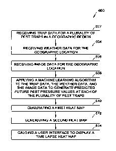
source, a grower data source 210, and an another data source 212. Those of
skill in the
art will appreciate that data sources 130 shown in FIG. 2 are merely examples,
and that
system 100 may include any suitable number and type of data source.
[0038] Weather data source 202 provides weather data to PPP
computing device 112 for use in generating pest pressure predictions. Weather
data
may include, for example, temperature data (e.g., indicating current and/or
past
temperatures measured at one or more geographic locations), humidity data
(e.g.,
indicating current and/or past humidity at measured at one or more geographic
locations), wind data (e.g., indicating current and/or past wind levels and
direction
measured at one or more geographic locations.), rainfall data (e.g.,
indicating current
and/or past rainfall levels measured at one or more geographic locations), and
forecast
data (e.g., indicating future weather conditions predicted for one or more
geographic
locations).
[0039] Imaging data source 204 provides image data to PPP
computing device 112 for use in generating pest pressure predictions. Image
data may
include, for example, satellite images and/or drone images acquired of one or
more
geographic locations.
[0040] Trap data source 206 provides trap data to PPP computing
device 112 for use in generating pest pressure predictions. Trap data may
include, for
12
CA 03174472 2022-09-01
WO 2021/178622
PCT/US2021/020805
example, pest counts (e.g., expressed as number of a pest species, density of
the pest
species, or the like) from at least one pest trap in a geographic location.
Further, trap
data may include, for example, in the case of insects, pest type (e.g.,
taxonomic genus,
species, variety, etc.) and/or pest developmental stage and gender (e.g.,
larva, juvenile,
adult, male, female, etc.). The pest traps may be, for example, insect traps.
Alternatively, the pest traps may be any device capable of determining a pest
presence
and providing trap data to PPP computing device 112 as described herein. For
example,
in some embodiments, the pest traps are sensing devices operable to sense an
ambient
level of spores associated with one or more species of fungi. In such
embodiments, the
trap data may include, for example, number of spores (representing the pest
count),
fungus type, fungus developmental stage, etc.
[0041] In some embodiments, trap data source 206 is a pest trap
that
is communicatively coupled to PPP computing device 112 (e.g., over a wireless
communication link). Accordingly, in such embodiments, trap data source 206
may be
capable of automatically determining a pest count in the pest trap (e.g.,
using image
processing algorithms) and transmitting the determined pest count to PPP
computing
device.
[0042] Scouting data source 208 provides scouting data to PPP
computing device 112 for use in generating pest pressure predictions. Scouting
data
may include any data provided by a human scout that monitors one or more
geographic
locations. For example, the scouting data may include crop condition, pest
counts (e.g.,
manually counted at a pest trap by the human scout), etc. In some embodiments,
scouting data source 208 is one of client systems 114. That is, a scout can
both provide
scouting data to PPP computing device 112 and view pest pressure prediction
data
and/or heat map data using the same computing device (e.g., a mobile computing
device).
[0043] Grower data source 210 provides grower data to PPP
computing device 112 for use in generating pest pressure predictions. Grower
data may
include, for example, field boundary data, crop condition data, etc. Further,
similar to
13
CA 03174472 2022-09-01
WO 2021/178622
PCT/US2021/020805
scouting data source 208, in some embodiments, grower data source 210 is one
of client
systems 115. That is, a grower can both provide scouting data to PPP computing
device
112 and view pest pressure prediction data and/or heat map data using the same
computing device (e.g., a mobile computing device).
[0044] Other data source 212 may provide other types of data to
PPP
computing device 112 that are not available from data sources 202-210. For
example,
in some embodiments, other data source 212 includes a mapping database that
provides
mapping data (e.g., topographical maps of one or more geographic locations) to
PPP
computing device 112.
[0045] in the example embodiment, PPP computing device 112
receives data from at least one of data sources 202-212, and aggregates and
analyzes
that data (e.g., using machine learning) to generate pest pressure prediction
data, as
described herein. Further, PPP computing device 112 may also aggregate and
analyze
that data to generate heat map data, as described herein. The pest pressure
prediction
data and/or heat map data may be transmitted to client system 114 (e.g., for
displaying
to a user of client system 114).
[0046] In some embodiments, data from at least one of data
sources
202-210 is automatically pushed to PPP computing device 112 (e.g., without PPP
computing device 112 polling or querying data sources 202-210). Further, in
some
embodiments, PPP computing device 112 polls or queries (e.g., periodically or
continuously) at least one of data sources 202-210 to retrieve the associated
data.
[0047] FIG. 3 illustrates an example configuration of a server
system 301 such as PPP computing device 112 (shown in Figs 1 and 2), in
accordance
with one example embodiment of the present disclosure. Server system 301 may
also
include, but is not limited to, database server 116. In the example
embodiment, server
system 301 generates pest pressures prediction data and heat map data as
described
herein.
14
CA 03174472 2022-09-01
WO 2021/178622
PCT/US2021/020805
[0048] Server system 301 includes a processor 305 for executing
instructions. Instructions may be stored in a memory area 310, for example.
Processor
305 may include one or more processing units (e.g., in a multi-core
configuration) for
executing instructions. The instructions may be executed within a variety of
different
operating systems on the server system 301, such as UNIX, LINUX, Microsoft
Windows , etc. It should also be appreciated that upon initiation of a
computer-based
method, various instructions may be executed during initialization. Some
operations
may be required in order to perform one or more processes described herein,
while other
operations may be more general and/or specific to a particular programming
language
(e.g., C, C#, C++, Java, or other suitable programming languages, etc.).
[0049] Processor 305 is operatively coupled to a communication
interface 315 such that server system 301 is capable of communicating with a
remote
device such as a user system or another server system 301. For example,
communication interface 315 may receive requests from a client system 114 via
the
Internet, as illustrated in FIG. 2.
[0050] Processor 305 may also be operatively coupled to a
storage
device 134. Storage device 134 is any computer-operated hardware suitable for
storing
and/or retrieving data. In some embodiments, storage device 134 is integrated
in server
system 301. For example, server system 301 may include one or more bard disk
drives
as storage device 134. In other embodiments, storage device 134 is external to
server
system 301 and may be accessed by a plurality of server systems 301. For
example,
storage device 134 may include multiple storage units such as hard disks or
solid state
disks in a redundant array of inexpensive disks (RAID) configuration. Storage
device
134 may include a storage area network (SAN) and/or a network attached storage
(N AS) system.
[0051] In some embodiments, processor 305 is operatively
coupled
to storage device 134 via a storage interface 320. Storage interface 320 is
any
component capable of providing processor 305 with access to storage device
134.
Storage interface 320 may include, for example, an Advanced Technology
Attachment
CA 03174472 2022-09-01
WO 2021/178622
PCT/US2021/020805
(ATA) adapter, a Serial ATA (SATA) adapter, a Small Computer System Interface
(SCSI) adapter, a RAID controller, a SAN adapter, a network adapter, and/or
any
component providing processor 305 with access to storage device 134.
[0052] Memory area 310 may include, but are not limited to,
random
access memory (RAM) such as dynamic RAM (DRAM) or static RAM (SRAM), read-
only memory (ROM), erasable programmable read-only memory (EPROM),
electrically erasable programmable read-only memory (EEPROM), and non-volatile
RAM (NVRAM). The above memory types are examples only, and are thus not
limiting as to the types of memory usable for storage of a computer program.
[0053] FIG. 4 illustrates an example configuration of a client
computing device 402. Client computing device 402 may include, but is not
limited to,
client systems ("client computing devices") 114. Client computing device 402
includes
a processor 404 for executing instructions. In some embodiments, executable
instructions are stored in a memory area 406. Processor 404 may include one or
more
processing units (e.g., in a multi-core configuration). Memory area 406 is any
device
allowing information such as executable instructions and/or other data to be
stored and
retrieved. Memory area 406 may include one or more computer-readable media.
[0054] Client computing device 402 also includes at least one
media
output component 408 for presenting information to a user 400. Media output
component 408 is any component capable of conveying inknnation to user 400. In
some embodiments, media output component 408 includes an output adapter such
as a
video adapter and/or an audio adapter. An output adapter is operatively
coupled to
processor 404 and operatively couplable to an output device such as a display
device
(e.g., a liquid crystal display (LCD), organic light emitting diode (OLED)
display,
cathode ray tube (CRT), or "electronic ink" display) or an audio output device
(e.g., a
speaker or headphones).
[0055] In some embodiments, client computing device 402
includes
an input device 410 for receiving input from user 400. Input device 410 may
include,
for example, a keyboard, a pointing device, a mouse, a stylus, a touch
sensitive panel
16
CA 03174472 2022-09-01
WO 2021/178622
PCT/US2021/020805
(e.g., a touch pad or a touch screen), a camera, a gyroscope, an
accelerometer, a position
detector, and/or an audio input device. A single component such as a touch
screen may
fimetion as both an output device of media output component 408 and input
device 410.
[0056] Client computing device 402 may also include a
communication interface 412, which is communicatively couplable to a remote
device
such as server system 301 or a web server. Communication interface 412 may
include,
for example, a wired or wireless network adapter or a wireless data
transceiver for use
with a mobile phone network (e.g., Global System for Mobile communications
(GSM),
3G, 4G, 5G, or Bluetooth) or other mobile data network (e.g., Worldwide
Interoperability for Microwave Access (WIMAX)).
[0057] Stored in memory area 406 are, for example, computer-
readable instructions for providing a user interface to user 400 via media
output
component 408 and, optionally, receiving and processing input from input
device 410.
A user interface may include, among other possibilities, a web browser and
client
application. Web browsers enable users 400 to display and interact with media
and
other information typically embedded on a web page or a website from a web
server.
A client application allows users 400 to interact with a server application.
The user
interface, via one or both of a web browser and a client application,
facilitates display
of pest pressure information provided by PPP computing device 112. The client
application may be capable of operating in both an online mode (in which the
client
application is in communication with PPP computing device 112) and an offline
mode
(in which the client application is not in communication with PPP computing
device
112).
[0058] FIG. 5 is a flow diagram of an example method 500 for
generating pest pressure data. Method 500 may be implemented, for example,
using
PPP computing device 112.
[0059] Method 500 includes receiving 502 trap data for a
plurality
of pest traps in a geographic location. In the example embodiment, the trap
data
includes both current pest pressure and historical pest pressure at each of
the plurality
17
CA 03174472 2022-09-01
WO 2021/178622
PCT/US2021/020805
of traps. The tap data may be received 502 from, for example, trap data source
206
(shown in FIG. 2). Further, PPP computing device 112 may analyze the received
502
trap data to generate additional data. For example, from the received 502 trap
data, PPP
computing device 112 may determine, for a number of different pest pressure
levels
(e.g., defmed by suitable upper and lower thresholds), the number of traps at
each level.
Further, PPP computing device 112 may determine average pest pressures across
a
number of traps and/or across at least a portion of the geographic location.
This
additional data may be used in identifying correlations and predicting future
pest
pressures, as described herein.
[0060] Method 500 further includes receiving 504 weather data
502
for the geographic location. In the example embodiment, the weather data
includes
both current and historical weather conditions for the geographic location.
Further, in
some embodiments, the weather data may include predicted future weather
conditions
for the geographic location. The weather data may be received 504 from, for
example,
weather data source 202 (shown in FIG. 2).
[0061] In the example embodiment, method 500 further includes
receiving 506 image data for the geographic location. The image data may
include, for
example, satellite and/or drone image data. The image data may be received 506
from,
for example, imaging data source 204 (shown in FIG. 2).
[0062] Further, method 500 includes identifying 508 at least
one
geospatial feature within the geographic location or proximate the geographic
location.
[0063] As used herein, a µgeospatial feature' refers to a
geographic
feature or structure that may have an impact on pest pressure. For example, a
geographic feature may include a body of water (e.g., a river, a stream, a
lake, etc.), an
elevation feature (e.g., a mountain, a hill, a canyon, etc.), a transportation
route (e.g., a
road, a railroad track, etc.), a farm location, or a factory (e.g., a cotton
factory).
[0064] In one embodiment, the at least geospatial feature is
identified 508 from existing map data. For example, PPP computing device 112
may
18
CA 03174472 2022-09-01
WO 2021/178622
PCT/US2021/020805
retrieve previously generated maps (e.g., topographical maps, elevation maps,
road
maps, surveys, etc.) from a map data source (such as other data source 212
(shown in
FIG. 2)), the previously generated maps demarcating the one or more geospatial
features.
[0065] In another embodiment, PPP computing device 112
identifies 508 the one or more geospatial features by analyzing the received
506 image
data. For example, PPP computing device 112 may apply raster processing to the
image
data to generate a digital elevation map, where each pixel (or other similar
subdivision)
of the digital elevation map is associated with an elevation value. Then,
based on the
elevation values, PPP computing device 112 identifies 508 the one or more
geospatial
features from the digital elevation map. For example, elevation features
and/or bodies
of water may be identified using such techniques.
[0066] Method 500 further includes applying 510 a machine
learning algorithm to the trap data, the weather data, the image data, and the
at least one
identified geospatial feature to identify a correlation between pest pressure
and the at
least one geospatial feature. Applying 510 the machine learning algorithm to
the trap
data, the weather data, the image data, and the at least one identified
geospatial feature
may be seen as applying 510 a machine learning-based scheme to the trap data,
the
weather data, the image data, and the at least one identified geospatial
feature to identify
a correlation between pest pressure and the at least one geospatial feature.
In one or
more example embodiments, applying 510 the machine learning algorithm to the
trap
data, the weather data, the image data, and the at least one identified
geospatial feature
may include determining a pest pressure value associated with a pest trap,
based on a
relation (e.g. a correlation) between pest pressure and the at least one
geospatial feature.
[0067] In some embodiments, PPP computing device 112 may
determine, by applying 510 the machine learning algorithm, that pest pressure
(e.g., at
the location of a pest trap) varies based on a distance from the at least one
identified
geospatial feature. For example, PPP computing device 112 may determine that
pest
pressure is higher at locations proximate to a body of water (e.g., due to
increased pest
19
CA 03174472 2022-09-01
WO 2021/178622
PCT/US2021/020805
levels at the body of water). In another example, PPP computing device 112 may
determine that pest pressure is higher at locations proximate a transportation
route (e.g.,
due to increased pest levels resulting from material transported alone the
transportation
route). In yet another example, PPP computing device 112 may determine that
pest
pressure is higher at locations proximate a factory (e.g., due to increased
pest levels
resulting from materials processed at the factory). In yet other examples, PPP
computing device 112 may determine that pest pressure is reduced at locations
proximate the at least one identified geospatial feature.
[0068] Those of skill in the will appreciate that applying 510
the
machine learning algorithm may identify other correlations between pest
pressure at the
at least one geospatial feature. Specifically, the machine learning algorithm
considers
the trap data, the weather data, the image data, and the at least one
identified geospatial
feature in combination, and is capable of detecting complex interactions
between those
different types of data that may not be ascertainable by a human analyst. For
example,
non-distance-based correlations between the at least one identified geospatial
feature
and pest pressure may be identified in some embodiments.
[0069] For example, in one or more example embodiments,
applying 510 the machine learning algorithm to the trap data, the weather
data, the
image data, and the at least one identified geospatial feature may include
determining
a pest pressure value associated with a pest trap, based on a model (e.g. a
machine
learning model, a pest lifecycle model) characterizing a relation (e.g. a
correlation)
between pest pressure and the trap data (optionally wherein the trap data
includes insect
data, and/or developmental stage data of the insect). Further, in one or more
example
embodiments, applying 510 the machine learning algorithm to the trap data, the
weather
data, the image data, and the at least one identified geospatial feature may
include
determining a pest pressure value associated with a pest trap, based on a
model (e.g. a
machine learning model) characterizing a relation (e.g. a correlation) between
pest
pressure, the trap data, and the weather data.
CA 03174472 2022-09-01
WO 2021/178622
PCT/US2021/020805
[0070] Further, in some embodiments, pest pressure for a first
pest
may be correlated to pest pressure for a second, different pest, and that
correlation may
be detected using PPP computing device 112. For example, the at least one
geospatial
feature is a particular field having a known high pest pressure for the second
pest. Using
the systems and methods described herein, PPP computing device 112 may
determine
that locations proximate the particular field generally have a high pest
pressure for the
first pest, which correlates to the pest pressure level of the second pest in
the particular
field. These "inter-pest" correlations may be complex relationships that are
identifiable
by PPP computing device 112, but that would not be identifiable by a human
analyst.
Similarly, "inter-crop" correlations may be identified by PPP computing device
112
between nearby geographic locations that product different crops.
[0071] Subsequently, method 500 includes generating 512
predicted
future pest pressures for the geographic location based on at least the
identified
correlation. Specifically, PPP computing device 112 uses the identified
correlation, in
combination with one or more models, algorithms, etc. to predict future pest
pressure
values for the geographic location. For example, PPP computing device 112 may
utilize
spray tinier models, pest lifecycle models, etc. in combination with the
identified
correlation, trap data, weather data, and image data to generate 512 predicted
future
pest pressures based on identified patterns. Those of skill in the art will
appreciate that
other types of data may also be incorporated to generated 512 predicted future
pest
pressures. For example, previously planted crop data, neighboring farm data,
field
water level data, and/or soil type data may be considered when predicting
future pest
pressures. In one or more example methods, the method 500 further includes
outputting,
based on the predicted future pest pressures, a control signal for controlling
one or more
additional systems at the geographic location, such as a system for monitoring
pest
pressure at the geographic location, a system for controlling pest pressure at
the
geographic location, and/or a pest treatment system at the geographic
location.
[0072] As one example of a model, developmental stages of a
pest
of interest (e.g., an insect, or a fungus) may be governed by an ambient
temperature.
21
CA 03174472 2022-09-01
WO 2021/178622
PCT/US2021/020805
Accordingly, using a "degree day" model, developmental stages of the pest may
be
predicted based on heat accumulation (e.g., determined from temperature data).
[0073] The generated 512 predicted future pest pressures are
one
example of pest pressure prediction data that may be transmitted to and
displayed on a
user computing device, such as client system 114 (shown in FIGS. 1 and 2). For
example, the predicted future pest pressures may be transmitted to the user
computing
device to cause the user computing device to present the predicted future pest
pressures
in a textual, graphical, and/or audio format, or any other suitable format. As
described
below in detail, in some embodiments, one or more heat maps illustrating
predicted
future pest pressures are displayed on the user computing device.
[0074] From the generated 512 predicted future pest pressures,
in
some embodiments, the systems and methods described herein may also be used to
generate (e.g., using machine learning) a treatment recommendation for the
geographic
location to address the predicted future pest pressures. For example, with an
accurate
prediction of future pest pressures in place, PPP computing device 112 may
automatically generate a treatment plan for the geographic location to
mitigate future
levels of high pest pressure. The treatment plan may specify, for example, one
or more
substances (e.g., pesticides, fertilizers, etc.) and specific times when those
one or more
substances should be applied (e.g., daily, weekly etc.). Alternatively, the
treatment plan
may include other data to facilitate improving agricultural performance in
view of
predicted future pest pressures.
[0075] Further, in some embodiments, the generated 512
predicted
future pest pressures are used (e.g., by PPP computing device 112) to control
additional
systems. In one embodiment, a system for monitoring pest pressure (e.g., a
system
including pest traps) may be controlled based on the predicted future pest
pressures.
For example, the PPP computing device 112 may be configured to output, based
on the
future pest pressures, a control signal for controlling one or more additional
systems,
such as a system for monitoring pest pressure, a system for controlling pest
pressure,
and/or a pest treatment system. For example, the heat map computing device may
be
22
CA 03174472 2022-09-01
WO 2021/178622
PCT/US2021/020805
configured to output, based on the future pest pressures, a control signal for
controlling
one or more additional systems, such as a system for monitoring pest pressure,
a system
for controlling pest pressure, and/or a pest treatment system. For example, a
reporting
frequency and/or type of trap data reported by one or more pest traps may be
modified
based on the predicted future pest pressures. In another example, spraying
equipment
(e.g., for spraying pesticides) or other agricultural equipment may be
controlled based
on the predicted future pest pressures.
[0076] As noted above, PPP computing device 112 may also
generate one or more heat maps using pest pressure prediction data. For the
purposes
of this discussion, PPP computing device 112 may be referred to herein as heat
map
generation computing device 112.
[(X)77] FIG. 6 is a flow diagram of an example method 600 for
generating heat maps. Method 600 may be implemented, for example, using heat
map
generation computing device 112 (shown in FIG. 1).
[0078] Method 600 includes receiving 602 trap data for a
plurality
of pest traps in a geographic region. In the example embodiment, the trap data
includes
both current pest pressure and historical pest pressure at each of the
plurality of traps.
The trap data may be received 602 from, for example, trap data source 206
(shown in
FIG. 2).
[0079] Further, method 600 includes receiving 604 weather data
for
the geographic location. In the example embodiment, the weather data includes
both
current and historical weather conditions for the geographic location.
Further, in some
embodiments, the weather data may include predicted future weather conditions
for the
geographic location. The weather data may be received 604 from, for example,
weather
data source 202 (shown in FIG. 2).
[0080] In the example embodiment, method 600 further includes
receiving 606 image data for the geographic location. The image data may
include, for
23
CA 03174472 2022-09-01
WO 2021/178622
PCT/US2021/020805
example, satellite and/or drone image data. The image data may be received 606
from,
for example, imaging data source 204 (shown in FIG. 2).
[0081] Method 600 further includes applying 608 a machine
learning algorithm to the trap data, the weather data, and the image data to
generate
predicted future pest pressure values at each of the plurality of pest traps.
[0082] In addition, method 600 includes generating 610 a first
heat
map and generating 612 a second heat map. In the example embodiment, the first
heat
map is associated with a first point in time and the second heat map is
associated with
a different second point in time. The first and second heat maps may be
generated 610,
612 as follows.
[0083] In the example embodiment, each heat map is generated by
plotting a plurality of nodes on a map of the geographic location. Each node
corresponds to the location of particular pest trap of the plurality of pest
traps. Further,
in the example embodiment, each node is displayed in a color that represents
the pest
pressure value for the corresponding test trap at the associated point in
time. In one
example, each node is displayed green (indicating a low pest pressure value),
yellow
(indicating a moderate pest pressure value), or red (indicating a high pest
pressure
value). In FIGS. 7-9, green is indicated by a diagonal line pattern, yellow is
indicated
by a cross hatch pattern, and red is indicated by a dot pattern. Those of
skill in the art
will appreciate that other numbers of colors and different colors may be used
in the
embodiments described herein. Depending on the point in time associated with
the heat
map, the color of the node may indicate a past pest pressure value (if the
point in time
is in the past, for example a specific day preceding the current date, or
preceding the
date of the latest reading of trap data), a current pest pressure value (if
the point in time
is the present, for example the current date, or the date of the latest
reading of trap data),
or a predicted future pest pressure value (if the point in time is in the
future, for example
a specific day after the present date, or after the date of the latest reading
of trap data).
The future predicted pest pressure values may be generated, for example, using
machine
learning algorithms, as described herein.
24
CA 03174472 2022-09-01
WO 2021/178622
PCT/US2021/020805
[0084] To complete the heat map, at least some of the remaining
portions of the map including the colored nodes are colored. Specifically,
remaining
portions of the map are colored to generate a continuous map of pest pressure
values.
In the example embodiment, the remaining portions are colored by interpolating
between the pest pressure values at the plurality of nodes.
[0085] In one embodiment, interpolation is performed using an
inverse distance weighting (IDW) algorithm, wherein points on remaining
portions of
the map are colored based on their distance from known pest pressure values at
the
nodes. For example, in such an embodiment, pest pressure values for locations
without
nodes may be calculated based on a weighted average of inverse distances
nearby
nodes. This embodiment operates under the assumption that pest pressure at a
particular point will be more strongly influenced by nodes that are closer (as
opposed
to more distant nodes). In other embodiments, interpolation may be performed
based
on other criteria in addition to, or alternative to distance from the nodes.
[0086] With pest pressure values generated for at least some of
the
remaining portions of the map (using interpolation, as described above), those
portions
are colored based on the generated pest pressure values. As with the nodes, in
one
example, green indicates a low pest pressure value, yellow indicates a
moderate pest
pressure value, and red indicates a high pest pressure value. The thresholds
for the
different colors may be set, for example, based on historical pest pressure,
and may be
adjusted over time (automatically or based on user input). Those of skill in
the art will
appreciate that these three colors are only examples, and that any suitable
coloring
scheme may be used to generate the heat maps described herein.
[0087] In the example embodiment, the first and second heat
maps
are stored in a database, such as database 120 (shown in FIG. 1). Accordingly,
in this
embodiment, when a user views heat maps on a user device (e.g., a mobile
computing
device), as described below, the heat maps have already been previously
generated and
stored by heat map generation computing device 112. Alternatively, heat maps
may be
generated and displayed in real-time based on the user's request.
CA 03174472 2022-09-01
WO 2021/178622
PCT/US2021/020805
[0088] With the first and second heat maps generated 610, 612,
in
the example embodiment, method 600 further includes causing 614 a user
interface to
display a time lapse beat map. The user interface may be, for example, a user
interface
displayed on client device 114 (shown in FIGS. 1 and 2). The user interface
may be
implemented, for example, via an application installed on the client device
114 (e.g.,
an application provided by the entity that operates heat generation computing
device
112). In one or more example methods, the method 600 further includes
outputting,
based on the predicted future pest pressures, a control signal for controlling
one or more
additional systems, such as a system for monitoring pest pressure, a system
for
controlling pest pressure, and/or a pest treatment system.
[0089] The time lapse heat map displays an animation on the
user
interface. Specifically, in the example embodiment, the time lapse heat map
dynamically transitions between a plurality of previously generated heat maps
(e.g., the
first and second heat maps) over time, as described below. Accordingly, by
viewing
the dynamic heat map, users can easily see and appreciate changes in pest
pressure over
time for the geographic region. The time lapse heat map may display past,
current,
and/or future pest pressure values for the geographic region.
[0090] It should be undeistood that, in example embodiment, the
second heat map for a second point in time is generated using predicted pest
pressure
values, and this second point in time refers to a point in time later than the
time of the
most recent current and historical pest pressure values (e.g., included in the
trap data)
incorporated into the machine learning algorithm. That is, the second point in
time
refers to a future point in time in such embodiments.
[0091] With respect to the first heat map for a first point in
time, in
the example embodiment, this is generated using pest pressure values for a
point in time
earlier than the second point in time. Accordingly, the pest pressure values
used for
generating the first heat map are generally either current or historical pest
pressure
values. In another embodiment, the first point in time is also a future point
in time, but
26
CA 03174472 2022-09-01
WO 2021/178622
PCT/US2021/020805
a different point in. time than the second point in time. Thus, the pest
pressure values
used for generating the first heat map are predicted pest pressure values as
well.
[0092] Within the scope of this disclosure, it should be
understood
that reference made herein to "a first heat map" and "a second heat map" and
to "the
first and second heat maps" can imply that one or more (e.g., a plurality of)
"intermediate heat maps" are generated using pest pressure values (e.g.
current,
historical or predicted pest pressure values, as the case may be) for various
points in
time between the first point in time and the second point in time. In such
cases, the
time lapse heat map displays a dynamic transition between the first heat map,
the one
or more intermediate heat maps, and the second heat map over time. In one
embodiment, the intermediate heat maps include one or more (e.g., a plurality
of)
intermediate heat maps generated using predicted pest pressure values. In
another
embodiment, the intermediate heat maps include one or more (e.g., a plurality
of)
intermediate heat maps generated using current and/or historical pest pressure
values.
In yet another embodiment, the intermediate heat maps include one or more
(e.g., a
plurality of) intermediate heat maps generated using predicted pest pressure
values and
one or more (e.g., a plurality of) intermediate heat maps generated using
current and/or
historical pest pressure values.
[0093] In one embodiment, to display the time lapse heat map,
each
previously generated heat map is displayed for a brief period of time before
instantaneously transitioning to the next heat map (e.g., in a slideshow
format).
Alternatively, in some embodiments, heat map generation computing device 112
temporally interpolates between consecutive heat maps to generate transition
data (e.g.,
using machine learning) between those heat maps. In such embodiments, the time
lapse
heat map displays a smooth evolution of pest pressure over time, instead of a
series of
static images.
[0094] FIG. 7 is a first screenshot 700 of a user interface
that may
be displayed on a computing device, such as client system 114 (shown in FIGS.
1 and
2). The computing device may be, for example, a mobile computing device.
27
CA 03174472 2022-09-01
WO 2021/178622
PCT/US2021/020805
[0095] First screenshot 700 includes a pest pressure heat map
702
that displays pest pressure associated with a particular pest and crop in a
region 704
including a field 706. In the example shown in first screenshot 700, the pest
is boll
weevil and the crop is cotton. Those of skill in the art will appreciate that
the heat maps
described herein may display pest pressure information for any suitable pest
and crop.
Further, in some embodiments, heat maps may display pest pressures for
multiple pests
in the same crop, one pest in multiple crops, or multiple pests in multiple
crops.
[0096] As shown in FIG. 7, field 706 is demarcated on heat map
702
by a field boundary 708. Field boundary 708 may be plotted on heat map 702 by
heat
map generation computing device 112 based on, for example, information
provided by
a grower associated with field 706. For example, the grower may provide
information
to heat map generation computing device 112 from a grower computing device,
such
as grower data source 210 (shown in FIG. 2).
[0097] Heat map 702 includes three nodes 710, corresponding to
three pest traps in field 706. As shown in F1G. 7, each node 710 has an
associated color
(here two red nodes and one yellow node). Further, in heat map 702, locations
not
including nodes 710 are colored by interpolating the pest pressure values at
nodes 710,
generating a continuous map of pest pressure values. Although only three nodes
710
are shown in FIG. 7, those of skill in the art will appreciate that the
additional pest traps
may be used to color portions of heat map 702. In this example, heat map 702
is a static
heat map that shows pest pressure at a particular point in time (e.g., one of
the first and
second heat maps described above).
[0098] First screenshot 700 further includes a time lapse
button 712
that, when selected by a user, causes a time lapse heat map to be displayed,
as described
herein.
[0099] FIG. 8 is a second screenshot 800 of the user interface
that
may be displayed on a computing device, such as client system 114 (shown in
FIGS. I
and 2). Specifically, second screenshot 800 shows an enlarged view of heat map
702.
28
CA 03174472 2022-09-01
WO 2021/178622
PCT/US2021/020805
The enlarged view may be generated, for example, in response to the user
making a
selection on the user interface to change a zoom level.
[00100] As shown in FIG. 8, additional information not shown in first
screenshot 700 is shown in the enlarged view. For example, an additional node
802
(representing an additional trap) is now visible. Further, an associated trap
name is
displayed with each node 710. In the exemplary embodiment, in the enlarged
view, the
user can select a particular node 710 to cause the user interface to display
pest pressure
data for that node 710. This is described in further detail below in
association with FIG.
10.
[00101] FIG. 9 is a third screenshot 900 of the user interface that may
be displayed on a computing device, such as client system 114 (shown in FIGS.
1 and
2). Specifically, third screenshot 9(Xl shows a time lapse heat map 902. Time
lapse
heat map 902 may be displayed, for example, in response to the user selecting
time
lapse button 712 (shown in FIGS. 7 and 8).
[0102] As shown in FIG. 9, a timeline 904 is displayed in association
with time lapse heat map 902. Timeline 904 enables a user to quickly determine
which
time pest pressure is currently being shown for. Timeline 904 shows a range of
dates,
including historical and future dates in the example embodiment. Further,
timeline 904
includes a current time marker 906 indicating the current (i.e., present
time), as well as
a selected time marker 908 that indicates what time is associated with the
pest pressure
shown on time lapse heat map 902.
[00103] For example, in FIG. 9, timeline 904 extends from January 5
to February 2, the current day is January 26, and time lapse heat map 902
shows pest
pressures for January 29. Notably, the pest pressure shown in FIG. 9 is a
predicted
future pest pressure, as selected time marker 908 is later than current time
marker 906.
[00104] In one embodiment, a user can adjust selected time marker
908 (e.g., by selecting and dragging selected time marker 908) to manipulate
what time
is displayed by time lapse heat map 902. Further, in the example embodiment,
when
29
CA 03174472 2022-09-01
WO 2021/178622
PCT/US2021/020805
the user selects an activation icon 910, time lapse heat map 902 is displayed
as an
animation, automatically transitioning between different static heat maps to
show the
evolution of pest pressure over time. A stop icon 912 is also shown in
screenshot 900.
When the user has previously selected activation icon 910, the user can select
the stop
icon 912 to stop the animation and freeze time lapse heat map 902 at a desired
point in
time.
[00105] FIG. 10 is a fourth screenshot 1000 of the user interface that
may be displayed on a computing device, such as client system 114 (shown in
FIGS. 1
and 2). Specifically, fourth screenshot 1000 shows pest pressure data 1002 for
a
particular trap. Pest pressure data 1002 may be displayed, for example, in
response to
the user selecting a particular node 710 (as described above in reference to
FIG. 8). In
one embodiment, pest pressure data 1002 includes graphical data 1004 that
displays
pest pressure over time (e.g., current and historical pest pressure) and
textual data 1006
that summarizes predicted future pest pressure.
[00106] FIG. 11 shows is a fifth screenshot 1100 of the user interface
that may be displayed on a computing device, such as client system 114 (shown
in
FIGS. 1 and 2). The fifth screenshot 1100 shows a plurality of user interface
objects. A
user interface object refers herein to a graphical representation of an object
that is
displayed on the display of the computing device. The user interface object
may be
user-interactive, or selectable by a user input. For example, an image (e.g.,
icon), a
button, and text (e.g., hyperlink) each optionally constitute a user interface
object. The
user interface object may be displayed in any shape, any color and/or any
form. The
fifth screenshot 1100 shows user interface object 1101 representative of a
field
boundary and user interface object 1104 representative of a pest trap outside
the field
boundary. Specifically, fifth screenshot 1100 shows user interface object 1102
representative of a heat map indicative of current pest pressure values
associated with
a point in time within the current time period (such as a current month, a
current week,
a current season). The point in time may have been selected on the screenshot
900 of
Fig. 9, and more specifically by placing time marker 908 at the desired date
indicated
by 906. Specifically, fifth screenshot 1100 shows a heat map comprising user
interface
CA 03174472 2022-09-01
WO 2021/178622
PCT/US2021/020805
object 1103 representative of historical pest pressure values (or a heat map
indicative
thereof) associated with a point in time within a historical time period (such
as a month
of a previous year corresponding to the current month, a week of a previous
year
corresponding to the current week, a season of a previous year corresponding
to the
current season). The user interface object 1103 may be displayed, for example,
according to a past time or a past time period, such as a corresponding past
season
selected by a user input using user interface object 1105. In one or more
examples, the
heat map generation computing device and/or the client device and/or the
mobile
computing device may be configured to concurrently display (e.g. superimpose
and/or
overlay) user interface object 1102 representative of the heat map indicative
of current
pest pressure values associated with a point in time within the current time
period with
user interface object 1103 representative of historical pest pressure values
associated
with a point in time within a historical or past period corresponding to the
current time
period (such as the same season in a previous year). For example, historical
pest
pressure values comprise historical pest pressure for the past growing
season(s). For
example, fifth screenshot 1100 shows user interface object 1105 that, when
selected by
a user, causes a selection of the time period for historical pest pressure
values to be
displayed by 1103.
[00107] The user interface objects 1102 and 1103 may be displayed
in any shape or form and are not limited to the shape shown in Fig. 11. For
example,
the user interface objects 1102 and 1103 may be displayed as two user
interface objects
(e.g. shaped as discs or rings) superimposed or overlayed on top of each
other, and
having a color and/or texture indicative of the corresponding pest pressure
values. It
may be appreciated that in some regions and for some crops, a calendar year
may
actually have two (or more) growing seasons. With the disclosed technique, a
grower
is provided with information that can be used to compare the actual pest
pressure values
for the current season with the historical pest pressure values for past
season(s). The
same technique may be applied to compare the predicted fixture pest pressure
values for
a current time period or season with the historical pest pressure values for a
corresponding past season(s). The user interface may comprise a user interface
object
31
CA 03174472 2022-09-01
WO 2021/178622
PCT/US2021/020805
configured to receive user input for toggling or switching between displaying
user
interface objects representative of historical pest pressure values and
displaying user
interface objects representative of current pest pressure values.
[00108] The user interface may comprise a user interface object
configured to receive user input for toggling or switching between displaying
user
interface objects representative of pest pressure values of a first time
period (for
example for the current time period) and displaying user interface objects
representative
of pest pressure values of a second time period (for example a historical time
period).
[00109] FIG. 12 is a sixth screenshot 1200 of the user interface that
may be displayed on a computing device, such as client system 114 (shown in
FIGS. 1
and 2). Specifically, sixth screenshot 1200 shows pest pressure data 1202 for
a
particular trap. Pest pressure data 1202 may be displayed, for example, in
response to
the user selecting a particular node 710 (as described above in reference to
FIG. 8). In
one embodiment, pest pressure data 1202 includes graphical data 1204 that
displays
pest pressure values over time (e.g., pest pressure values for the current
time period),
graphical data 1208 that displays historical pest pressure values over time
for a
historical or past time period corresponding to the current period (such as
from 21 July
to 10 August of last year or of another earlier year) and optionally textual
data 1206
that summarizes predicted future pest pressure. The historical or past time
period for
displaying 1208, such as the specific past season or the specific past year,
may be
selected by a user using user interface object 1210. The screenshot 1200 may
also be
displayed in response to the user selecting a trap in screenshot 1100 of Fig.
11 where
the past period is already selected.
[00110] Further, in some embodiments, the generated heat maps
facilitate controlling additional systems. In one embodiment, a system for
monitoring
pest pressure (e.g., a system including pest traps) may be controlled (e.g. by
the pest
prediction computing device and/or the heat map generation computing device)
based
on the heat maps. For example, a reporting frequency and/or type of trap data
reported
by one or more pest traps may be modified based on the heat maps. In another
example,
32
CA 03174472 2022-09-01
WO 2021/178622
PCT/US2021/020805
spraying equipment (e.g., for spraying pesticides) or other agricultural
equipment may
be controlled based on the heat maps.
[00111] At least one of the technical problems addressed by this
system includes: i) inability to accurately monitor pest pressure; ii)
inability to
accurately predict future pest pressure; and iii) inability to communicate
pest pressure
information to a user in a comprehensive, straightforward manner.
[00112] The technical effects provided by the embodiments
described herein include at least i) monitoring pest pressure in real-time;
ii) accurately
predicting future pest pressure using machine learning; iii) controlling other
systems or
equipment based on predicted future pest pressures; iv) generating
comprehensive heat
maps illustrating pest pressure; v) generating time lapse heat maps that
dynamically
display changes in pest pressure over time; and vi) controlling other systems
or
equipment based on generated heat maps.
[00113] Further, a technical effect of the systems and processes
described herein is achieved by performing at least one of the following
steps: (i)
receiving trap data for a plurality of pest traps in a geographic location,
the trap data
including current and historical pest pressure values at each of the plurality
of pest traps;
(ii) receiving weather data for the geographic location; (iii) receiving image
data for the
geographic location; (iv) applying a machine learning algorithm to the trap
data, the
weather data, and the image data to generate predicted future pest pressure
values at
each of the plurality of pest traps; (v) generating a first heat map for a
first point in time
and a second heat map for a second point in time, the second heat map
generated using
the predicted future pest pressure values, the first and second heat maps each
generated
by a) plotting a plurality of nodes on a map of the geographic location, each
node
corresponding to one of the plurality of pest traps, each node having a color
that
represents the pest pressure value for the corresponding pest trap at the
associated point
in time, and b) coloring at least some remaining portions of the map of the
geographic
location to generate a continuous map of pest pressure values for the
geographic
location by interpolating between pest pressure values associated with the
plurality of
33
CA 03174472 2022-09-01
WO 2021/178622
PCT/US2021/020805
nodes at the associated point in time; and (vi) transmitting the first and
second heat
maps to a mobile computing device to cause a user interface on the mobile
computing
device to display a time lapse heat map that dynamically transitions between
the first
heat map and the second heat map over time, the user interface implemented via
an
application installed on the mobile computing device.
[00114] A processor or a processing element in the embodiments
described herein may employ artificial intelligence and/or be trained using
supervised
or unsupervised machine learning, and the machine learning program may employ
a
neural network, which may be a convolutional neural network, a deep learning
neural
network, or a combined learning module or program that learns in two or more
fields
or areas of interest. Machine learning may involve identifying and recognizing
patterns
in existing data in order to facilitate making predictions for subsequent
data. Models
may be created based. upon example inputs in order to make valid and reliable
predictions for novel inputs.
[00115] Additionally or alternatively, the machine learning programs
may be trained by inputting sample data sets or certain data into the
programs, such as
image data, text data, report data, and/or numerical analysis. The machine
learning
programs may utilize deep learning algorithms that may be primarily focused on
pattern
recognition, and may be trained after processing multiple examples. The
machine
learning programs may include Bayesian program learning (BPI), voice
recognition
and synthesis, image or object recognition, optical character recognition,
and/or natural
language processing --- either individually or in combination. The machine
learning
programs may also include natural language processing, semantic analysis,
automatic
reasoning, and/or machine learning.
[00116] In supervised machine learning, a processing element may
be provided with example inputs and their associated outputs, and may seek to
discover
a general rule that maps inputs to outputs, so that when subsequent novel
inputs are
provided the processing element may, based upon the discovered rule,
accurately
predict the correct output. In unsupervised machine learning, the processing
element
34
CA 03174472 2022-09-01
WO 2021/178622
PCT/US2021/020805
may be required to find its own structure in unlabeled example inputs. In one
embodiment, machine learning techniques may be used to extract data about the
computer device, the user of the computer device, the computer network hosting
the
computer device, services executing on the computer device, and/or other data.
[00117] Based uixm these analyses, the processing element may learn
how to identify characteristics and patterns that may then be applied to
analyzing trap
data, weather data, image data, geospatial (e.g., using one or more models) to
predict
future pest pressure.
[00118] As used herein, the term "non-transitory computer-readable
media" is intended to be representative of any tangible computer-based device
implemented in any method or technology for short-term and long-term storage
of
information, such as, computer-readable instructions, data structures, program
modules
and sub-modules, or other data in any device. Therefore, the methods described
herein
may be encoded as executable instructions embodied in a tangible, non-
transitory,
computer readable medium, including, without limitation, a storage device
and/or a
memory device. Such instructions, when executed by a processor, cause the
processor
to perform at least a portion of the methods described. herein. Moreover, as
used herein,
the term "non-transitory computer-readable media" includes all tangible,
computer-
readable media, including, without limitation, non-transitory computer storage
devices,
including, without limitation, volatile and nonvolatile media, and removable
an.d non-
removable media such as a firmware, physical and virtual storage, CD-ROMs,
DYDs,
and any other digital source such as a network or the Internet, as well as yet
to be
developed digital means, with the sole exception being a transitory,
propagating signal.
[00119] This written description uses examples to disclose the
disclosure, including the best mode, and also to enable any person skilled in
the art to
practice the embodiments, including making and using any devices or systems
and
performing any incorporated methods. The patentable scope of the disclosure is
defined
by the claims, and may include other examples that occur to those skilled in
the art.
Such other examples are intended to be within the scope of the claims if they
have
CA 03174472 2022-09-01
WO 2021/178622
PCT/US2021/020805
structmal elements that do not differ from the literal language of the claims,
or if they
include equivalent structural elements with insubstantial differences from the
literal
language of the claims.
36