Note: Descriptions are shown in the official language in which they were submitted.
WO 2021/250391
PCT/GB2021/051415
Navigation systems and methods
Field
The present invention relates to navigation systems and methods for a vehicle.
The present invention more particularly relates to navigation systems and
methods which do not need to rely on a Global Navigation Satellite System
(GNSS).
Background
Navigation by GNSS-enabled systems can be energetically expensive, and
limited by the requirement for satellite signal, meaning that navigation in
some
environments (for example indoor or deep sea) is not always possible. GNSS-
disabled systems, on the other hand, such as inertial navigation or dead-
reckoning can navigate in these environments due to emancipation from
satellite signals. These methods, however, often struggle with accuracy due to
their inability to determine absolute position in a global coordinate system
and
are therefore also unable to perform navigation from a 'cold start' (i.e. when
the system itself must determine its location or starting coordinates).
In the case of unmanned underwater vehicles (UUVs), many existing solutions
require the vehicle to stay close to the surface of the water, or at least
return to
the surface reasonably frequently to receive GNSS input and therefore re-
orient itself relative to a target location. This presents numerous
detriments, in
the form of damage to the UUV due to strong surface currents, conspicuity and
fouling of the UUV by bacteria or other organisms as the vehicle stays in the
warmer and lighter waters near the surface. Each of these detriments can
cause mission failures.
The present invention seeks to provide improved navigation systems and
methods which alleviate at least some of the problems outlined herein.
1
CA 03178108 2022- 11- 7
WO 2021/250391
PCT/GB2021/051415
Summary
According to one aspect of the present invention, there is provided a
navigation system for a vehicle, the system comprising: a plurality of
sensors,
each sensor being configured to sense a respective physical property and to
output a set of physical parameter data which is indicative of the physical
property; a weighting module which is configured to generate a weight value
for each set of physical parameter data based on at least one further
parameter; a memory for storing predetermined physical parameter data and
associated predetermined location data; a compiler module which is
configured to: rank the sets of physical parameter data according to the
weight
values, match at least some of the ranked sets of physical parameter data with
sets of predetermined physical parameter data which are stored in the
memory, generate vehicle location data by combining the predetermined
location data which is associated with the sets of predetermined physical
parameter data according to the respective weight values, and compile vehicle
navigation data comprising at least one of a bearing or distance from the
vehicle to a target based on the vehicle location data and target location
data
indicative of the location of the target.
In some embodiments, the at least one further parameter comprises a
navigation accuracy parameter which is indicative of a required accuracy for
the vehicle navigation data.
In some embodiments, the navigation accuracy parameter changes over time
such that: at a first time the navigation accuracy parameter is indicative of
a
first level of accuracy, and at a second time, which is later than the first
time,
the navigation accuracy parameter is indicative of a second level of accuracy
which is higher than the first level of accuracy.
2
CA 03178108 2022- 11- 7
WO 2021/250391
PCT/GB2021/051415
In some embodiments, the at least one further parameter comprises a speed
parameter which is indicative of a speed at which the vehicle is navigating to
a
target.
In some embodiments, the at least one further parameter comprises a secrecy
parameter which is indicative of whether it is acceptable for the vehicle to
be
observed while the vehicle is navigating to a target.
In some embodiments, the at least one further parameter comprises a
longevity parameter which is indicative of the length of time over which the
vehicle is navigating to a target.
In some embodiments, the at least one further parameter comprises a fuel
parameter which is indicative of the fuel which is available to the vehicle
for
navigation to a target.
In some embodiments, the plurality of sensors comprise at least one weather
sensor which is configured to sense a physical property of the weather in the
vicinity of the vehicle.
In some embodiments, the plurality of sensors comprise an acoustic sensor
which is configured to sense sound in the vicinity of the vehicle.
In some embodiments, the acoustic sensor is configured to sense sonar in the
vicinity of the vehicle when the vehicle is underwater.
In some embodiments, the plurality of sensors comprise a chemical sensor
which is configured to sense the level of a chemical in the vicinity of the
vehicle.
3
CA 03178108 2022- 11- 7
WO 2021/250391
PCT/GB2021/051415
In some embodiments, the chemical sensor is configured to sense the
chemical composition of water in the vicinity of the vehicle when the vehicle
is
underwater.
In some embodiments, the chemical sensor is configured to sense the salinity
of water in the vicinity of the vehicle when the vehicle is underwater.
In some embodiments, the plurality of sensors comprise a camera which is
configured to capture images of the environment surrounding the vehicle.
In some embodiments, the camera is configured to capture images celestial
bodies using at least one of the visible light spectrum, the infrared spectrum
or
the ultraviolet spectrum.
In some embodiments, the camera is configured to capture images of the
polarised light field of the sun.
In some embodiments, the system further comprises: an image recognition
processing module which is configured to perform image recognition on image
data provided by the camera
In some embodiments, the plurality of sensors comprise a flow sensor which is
configured to sense the flow of water in the vicinity of the vehicle when the
vehicle is underwater.
In some embodiments, the plurality of sensors comprise a magnetic field
sensor which is configured to sense the intensity of the Earth's magnetic
field
at the location of the vehicle.
4
CA 03178108 2022- 11- 7
WO 2021/250391
PCT/GB2021/051415
In some embodiments, the magnetic field sensor is configured to sense the
inclination of the Earth's magnetic field at the location of the vehicle.
In some embodiments, the system is configured to calculate the timing of the
quiet diurnal variation (QDV) of the Earth's magnetic field using the sensed
intensity and/or inclination of the Earth's magnetic field.
In some embodiments, the plurality of sensors comprise a temperature sensor
which is configured to sense a temperature in the vicinity of the vehicle.
In some embodiments, the plurality of sensors comprise a depth sensor which
is configured to sense the depth of the vehicle when the vehicle is
underwater.
In some embodiments, the depth sensor comprises at least one of a pressure
sensor, a sonar device or a laser range finder.
In some embodiments, the system further comprises: an inertial navigation
module which is configured to record the acceleration of the vehicle over time
and to output inertial navigation data as physical parameter data.
In some embodiments, the plurality of sensors comprise a power supply
sensor which is configured to sense a physical property of a power supply
carried by the vehicle.
In some embodiments, the predetermined physical parameter data and
associated predetermined location data comprise at least one of tidal data,
geomagnetic anomaly data or light level data based on the sun or moon rise
and set.
5
CA 03178108 2022- 11- 7
WO 2021/250391
PCT/GB2021/051415
In some embodiments, the system is configured to compile the vehicle
navigation data based on predetermined tidal data to control the navigation of
the vehicle such that a tidal stream assists with the propulsion of the
vehicle.
According to another aspect of the present invention, there is provided a
vehicle comprising the navigation system of any one of claims 1 to 28 as
defined hereinafter.
According to a further aspect of the present invention, there is provided a
navigation method for a vehicle, the method comprising: sensing a plurality of
physical properties and providing a plurality of sets of physical parameter
data,
each set of physical parameter data being indicative of one of the physical
properties; generating a weight value for each set of physical parameter data
based on at least one further parameter; ranking the sets of physical
parameter data according to the weight values; matching at least some of the
ranked sets of physical parameter data with sets of predetermined physical
parameter data which are stored in a memory, the memory storing
predetermined physical parameter data and associated predetermined location
data; generating vehicle location data by combining the predetermined location
data which is associated with the sets of predetermined physical parameter
data according to the respective weight values; and compiling vehicle
navigation data comprising at least one of a bearing or distance from the
vehicle to a target based on the vehicle location data and target location
data
indicative of the location of the target.
Brief description of the drawings
In order that the invention may be more readily understood, and so that
further
features thereof may be appreciated, embodiments of the invention will now be
described, by way of example, with reference to the accompanying drawings in
which:
6
CA 03178108 2022- 11- 7
WO 2021/250391
PCT/GB2021/051415
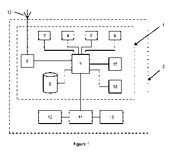
Figure 1 is a schematic diagram showing a navigation system of some
embodiments.
Detailed description
Animals are capable of travelling long distances without access to GNSS
information and can often navigate in complete darkness. It is suspected that
many species which are capable of long-distance travel have some form of
magnetic sense and are thereby able to determine their position relative to a
desired location. This suggests that variations in the intensity or
orientation of
the Earth's magnetic field may provide sufficient information to determine a
required bearing upon which to travel to reach a desired location. Other
studies from animals (e.g. salmon) have demonstrated that they are capable of
remembering locations based on the local magnetic field intensity, which
implies that it may also be possible to estimate the absolute position of a
system in terms of global coordinates.
The systems and methods described herein take inspiration from studies of
navigation of animals to address technical problems with navigating vehicles
in
challenging environments.
True navigation implies movement to a target location (e.g. known target
location) from a current location that may not have been visited before. The
least information required is a direction of travel with respect to a fixed
heading, but a more useful set of information is a direction and a distance to
target. The usual theoretical approach is to split true navigation into two
steps:
a map step, and a compass step. The map step is used to determine the
bearing and distance to the target and the compass step is used to attempt to
travel in the correct direction.
7
CA 03178108 2022- 11- 7
WO 2021/250391
PCT/GB2021/051415
For a two-dimensional map, two scalar components are required to form a
heading vector for navigation. The normal example is latitude and longitude.
These are the most often used two components (or coordinates) in the
standard bi-coordinate map system. If two scalar values are known (one
number for latitude and one for longitude) for the current location of a
vehicle
and the same two are known for a target location, it is possible to plot a
heading from the current location to the target location with respect to
geographic north. This is because the latitude and longitude are always
orthogonal (and never parallel) to each other and they both have a gradient
which is a direction (a vector quantity) that is always consistent with
respect to
geographic north.
A compass points to magnetic north and so there needs to be some
adjustment for correct navigation. A map of declination for every point on the
Earth's surface is needed in order to achieve a perfect bearing every time.
Generally declination changes slowly over most of the Earth's surface and is
consistent over several years, but for precise navigation a change in
declination is an important factor.
Alternatives for latitude and longitude can be thought of as proxies for
latitude
and longitude. For instance, the position of the sun in the sky (height above
the horizon at a certain time) is a good proxy for longitude. In the same way
the fixed stars and moon can be used as a proxy for longitude ¨ there are
examples of animals using a sun clock based compass and navigating by the
position of the Milky Way for instance. There are many animals that have
been shown to have an inclination compass, and magnetic inclination is a
good proxy for latitude. However, unlike animals, as described below some
embodiments are configured to measure and model many different physical
cues across the world and use them as (local) proxies for latitude and
longitude.
8
CA 03178108 2022- 11- 7
WO 2021/250391
PCT/GB2021/051415
Referring now to figure 1 of the accompanying drawings, a navigation system
1 of some embodiments is installed within a vehicle 2. In the embodiment
shown in figure 1, the navigation system 1 is integrated within the vehicle 2.
However, in other embodiments, the navigation system is a self-contained
device or a collection of devices which are configured to be carried by a
vehicle in order to provide a navigation system for the vehicle.
The vehicle 2 may be any type of vehicle which may be configured to travel
across land, across water, underwater or by air. In some embodiments, the
vehicle 2 is an autonomous or semi-autonomous vehicle which is configured to
navigate autonomously to a target location.
In some embodiments, the vehicle 2 is an unmanned underwater vehicle
(UUV). In other embodiments, the vehicle 2 is an unmanned air vehicle
(UAV). In further embodiments, the vehicle 2 is an autonomous or semi-
autonomous land vehicle.
The system 1 comprises a plurality of sensors 3-6. In the embodiment shown
in figure 1, there are four sensors 3-6 but in other embodiments there are a
greater or lower number of sensors.
Each sensor 3-6 is configured to sense a respective physical property and to
output a set of physical parameter data which is indicative of the physical
property.
In some embodiments, the sensors 3-6 comprise at least one weather sensor
which is configured to sense a physical property of the weather in the
vicinity
of the vehicle 2.
9
CA 03178108 2022- 11- 7
WO 2021/250391
PCT/GB2021/051415
In some embodiments, the sensors 3-6 comprise at least one acoustic sensor
which is configured to sense sound in the vicinity of the vehicle 2. In some
embodiments, the acoustic sensor is configured to sense sonar in the vicinity
of the vehicle 2 when the vehicle 2 is underwater. In some embodiments, the
at least one acoustic sensor is configured to sense passive acoustics which
are indicative of physical properties of the underwater environment in the
vicinity of the vehicle 2, such as shipping lanes, coastal features, islands
or
bridge piers.
In some embodiments, the sensors 3-6 comprise at least one chemical sensor
which is configured to sense the level of a chemical in the vicinity of the
vehicle 2. In some embodiments, the chemical sensor is configured to sense
the chemical composition of water in the vicinity of the vehicle 2 when the
vehicle 2 is underwater. In some embodiments, the chemical sensor is
configured to sense the salinity of water in the vicinity of the vehicle 2
when
the vehicle 2 is underwater. In some embodiments, the at least one chemical
sensor is configured for analysis or water sampling on board the vehicle 2 for
use in rivers or estuaries.
In some embodiments, the sensors 3-6 comprise at least one camera which is
configured to capture images of the environment surrounding the vehicle 2. In
some embodiments, the at least one camera is configured to capture images
of celestial bodies, such as the sun, moon and/or stars, using at least one of
the visible light spectrum, the infrared spectrum or the ultraviolet spectrum.
The physical parameter data from the at least one camera can be compared
with look up tables or models for the sun, moon and in order to derive
location
information which is indicative of the location of the vehicle 2. In some
embodiments, the at least one camera is configured to capture images of the
polarised light field of the sun since the polarised light field of the sun is
CA 03178108 2022- 11- 7
WO 2021/250391
PCT/GB2021/051415
especially useful for establishing the direction of geographic north at
certain
times of day.
In some embodiments, the system further comprises an image recognition
processing module which is configured to perform image recognition on image
data provided by the camera. In some embodiments, the image recognition
module is configured to recognise coastline in the image data provided by the
camera.
In some embodiments, the sensors 3-6 comprise at least one flow sensor
which is configured to sense the flow of water in the vicinity of the vehicle
2
when the vehicle 2 is underwater. In some embodiments, the at least one flow
sensor is configured to sense the currents or tides in the vicinity of the
vehicle
2. In these embodiments, the system is configured to measure the tidal
pattern (i.e. the rule of twelfths) when the vehicle 1 is positioned on the
bottom
of the sea bed near a shore. The measured tidal data can then be compared
with predetermined tidal data (e.g. using a tidal look up table) to establish
the
location of the vehicle 1. In addition, in some embodiments the system is
configured to examine the direction of the tide to help identify location.
In some embodiments, the sensors 3-6 comprise at least one magnetic field
sensor which is configured to sense the intensity of the Earth's magnetic
field
at the location of the vehicle 2. In some embodiments, the magnetic field
sensor is configured to sense the inclination of the Earth's magnetic field at
the
location of the vehicle 2. In some embodiments, the system is configured to
calculate the timing of the quiet diurnal variation (QDV) of the Earth's
magnetic
field using the sensed intensity and/or inclination of the Earth's magnetic
field.
The QDV of the Earth's magnetic field changes predictably during the day and
therefore can be used as a proxy for longitude to help identify the location
of
the vehicle 2.
11
CA 03178108 2022- 11- 7
WO 2021/250391
PCT/GB2021/051415
The QDV of the Earth's magnetic field is something that happens at a specific
time of day, dependent on where you are in the world. It can be measured
and thus if the vehicle has an on board clock then it can detect the point at
which the QDV happens and can compare it to when it is expected to happen
(e.g. using a look up table). For example, if we know that the QDV happens at
05:30am every day at a specific point in the world, but the system measures
the QDV actually occurring at 05:00am, then the system can deduce
information about its location i.e. the vehicle is West or East of where the
system originally anticipated for its current location.
In some embodiments, the sensors 3-6 comprise at least one temperature
sensor which is configured to sense a temperature in the vicinity of the
vehicle
2.
In some embodiments, the sensors 3-6 comprise at least one depth sensor
which is configured to sense the depth of the vehicle 2 when the vehicle 2 is
underwater. In some embodiments, the at least one depth sensor is a
pressure sensor, a sonar device or a laser range finder. A sonar ping from a
sonar device up to the surface is more reliable in low depth and especially
important for tidal monitoring.
Whereas, a laser range finder is less
conspicuous than sonar pings.
As will be described in more detail below, the physical parameter data from
the
sensors 3-6 can be compared with predetermined observations, models or
maps in order to derive location information which is indicative of the
location
of the vehicle 2.
12
CA 03178108 2022- 11- 7
WO 2021/250391
PCT/GB2021/051415
In some embodiments, the system further comprises an inertial navigation
module which is configured to record the acceleration of the vehicle 2 over
time and to output inertial navigation data as physical parameter data.
In some embodiments, the sensors 3-6 comprise at least one power supply
sensor which is configured to sense a physical property of a power supply
carried by the vehicle 2.
Returning now to figure 1 of the accompanying drawings, the system 1 further
comprises a central processing unit 7 which is coupled for communication with
a memory 8. Each of the sensors 3-6 is coupled to the central processing unit
7 so that the central processing unit 7 can receive and process the physical
parameter data which is output from the sensors 3-6.
The memory 8 is configured to store data to be processed by the central
processing unit 7 as well as data which is transmitted from the central
processing unit 7 to the memory 8. In some embodiments, the memory 8
stores predetermined physical parameter data and associated predetermined
location data. The predetermined physical parameter data and associated
predetermined location data is predetermined data which is stored as a model
or a database in the memory 8. In some embodiments, the predetermined
physical parameter data and associated predetermined location data
comprises at least one of tidal data, geomagnetic anomaly data or light level
data based on the sun or moon rise and set. In some embodiments, the
predetermined physical parameter data and associated predetermined location
data comprises a magnetic model of the Earth's main magnetic field for any
location and time and a model of the QDV for any location and time. In some
embodiments, the predetermined physical parameter data and associated
predetermined location data comprises models of other fixed or variable (in
space and time) magnetic field anomalies.
13
CA 03178108 2022- 11- 7
WO 2021/250391
PCT/GB2021/051415
In some embodiments, the system comprises a communication module 9
which is coupled for communication with the central processing unit 7. In
some embodiments, the communication module 9 is coupled to a
communication means, such as an antenna 10 to enable the system to
communicate wirelessly with another system, for instance to control the
vehicle 2 or to receive data from the vehicle 2. In some embodiments, the
communication module 9 is configured to communication with a
communication module of another vehicle, for instance to share navigation
data so that the vehicles can navigate together as a fleet.
In some embodiments, the system comprises a wired connection socket which
is coupled to the communication module 9 to enable another system to be
connected to the system by wire in order to program the vehicle 2 for
navigation prior to launching the vehicle on a mission.
In some embodiments, the central processing unit 7 or another part of the
system 1 is coupled to a vehicle control module 11 so that the system 1 can
control the movement and navigation of the vehicle 2. In these embodiments,
the vehicle control module 11 uses navigation data which is output by the
system 1 to control the movement of the vehicle 2. The vehicle control module
11 is coupled to a vehicle drive unit 12, such as a motor, to move the vehicle
2
and a vehicle steering unit 13 is configured to steer the vehicle 2.
In some embodiments, the system 1 is configured to generate inertial
navigation data by recording the path travelled by the vehicle 2. This
inertial
navigation data may be used to support or validate navigation data derived by
the system 1.
14
CA 03178108 2022- 11- 7
WO 2021/250391
PCT/GB2021/051415
The system 1 further comprises a weighting module 14 which is coupled for
communication with the central processing unit 7. The weighting module 14 is
configured to generate a weight value for each set of physical parameter data
based on at least one further parameter.
The weighting module 14 is configured to generate the weight values based on
at least one further parameter according to requirements for the navigation of
the vehicle 2. In some embodiments, the requirements for the navigation of
the vehicle 2 are mission planning requirements including at least one of
location accuracy, speed, secrecy or longevity for the vehicle during a
mission.
These requirements are discussed in further detail below.
The system 1 further comprises a compiler module 15 which is coupled for
communication with the central processing unit 7. The compiler module 15 is
configured to rank the sets of physical parameter data from the sensors 3-6
according to the weight values which are generated by the weighting module
14.
The compiler module 15 is configured to match at least some of the ranked
sets of physical parameter data with sets of predetermined physical parameter
data which are stored in the memory 8. The compiler module 15 is configured
to generate vehicle location data by combining the predetermined location
data which is associated with the sets of predetermined physical parameter
data according to the respective weight values. The compiler module 15 is
also configured to compile vehicle navigation data comprising at least one of
a
bearing or distance from the vehicle 2 to a target based on the vehicle
location
data and target location data indicative of the location of the target.
In some embodiments, the at least one further parameter comprises a
navigation accuracy parameter which is indicative of a required accuracy for
CA 03178108 2022- 11- 7
WO 2021/250391
PCT/GB2021/051415
the vehicle navigation data. For instance, the accuracy of the start and
finish
locations of the vehicle. A high of level of navigation accuracy may be
required when the vehicle is in close proximity to objects such as coastlines,
and a low level of navigation accuracy may be acceptable if the vehicle is far
from any objects, such as far out in the ocean.
In some embodiments, the navigation accuracy parameter changes over time
such that at a first time the navigation accuracy parameter is indicative of a
first level of accuracy, and at a second time, which is later than the first
time,
the navigation accuracy parameter is indicative of a second level of accuracy
which is higher than the first level of accuracy.
In some embodiments, the at least one further parameter comprises a speed
parameter which is indicative of a speed at which the vehicle is navigating to
a
target. For instance, the speed parameter may indicate a high speed in which
the fastest possible route might not be the shortest distance and there may be
no time available for the navigation system to survey the local area.
Conversely, the speed parameter may indicate a low speed in which the
slowest route might be the shortest distance and time may be available for the
navigation system to survey the local area.
In some embodiments, the at least one further parameter comprises a secrecy
parameter which is indicative of whether it is acceptable for the vehicle to
be
observed while the vehicle is navigating to a target. For instance, the
secrecy
parameter may indicate a high level of secrecy if the vehicle cannot be
observed (e.g. above the water line) or a low level of secrecy it is
acceptable
for the vehicle to be observed. If the secrecy requirement is low and the
vehicle 2 is underwater then the vehicle 2 can surface to take GPS
measurements but if it is high then the vehicle 2 must remain below a certain
16
CA 03178108 2022- 11- 7
WO 2021/250391
PCT/GB2021/051415
depth (e.g. sitting on the sea bed monitoring tidal currents, other currents,
surface height, acoustics, light levels or magnetic patterns).
In some embodiments, the at least one further parameter comprises a
longevity parameter which is indicative of the length of time over which the
vehicle is navigating to a target. For instance, the longevity parameter may
indicate a high level of longevity if the vehicle must avoid situations that
might
be detrimental to longevity of the vehicle, such as surface waters which can
lead to fowling and potential damage due to localised currents or foreign
objects. Conversely, the longevity parameter may indicate a low level of
longevity if the vehicle is being used for a short mission.
In some embodiments, the at least one further parameter comprises a fuel
parameter which is indicative of the fuel which is available to the vehicle
for
navigation to a target. In some embodiments, the system 1 is configured to
modify the navigation of the vehicle 2 if the fuel parameter is indicative of
the
available fuel being below a predetermined level. For instance, the system 1
may be configured to navigate the vehicle 2 to make use of tidal currents for
propulsion in order to reduce fuel consumption.
In some embodiments, the system 1 is configured to modify the weighting
values generated by the weighting module 14 if the at least one further
parameter changes. For instance the at least one further parameter may
change depending on the mission planning.
In one example mission, the start point of the vehicle 2 is close to a
coastline,
so the accuracy of the start point needs to be high. In this example, the
mission also requires a high level of secrecy as the vehicle cannot be
observed. The speed to target is low and the vehicle is required for multiple
missions, so a high level of longevity is necessary.
17
CA 03178108 2022- 11- 7
WO 2021/250391
PCT/GB2021/051415
In another example mission, the finish point of the vehicle 2 is in the middle
of
the ocean, so the location accuracy can be lower. Secrecy at this point is not
required but longevity of the vehicle 2 is still essential so the vehicle
cannot
surface and risk fouling/damage due to surface currents.
In a further example mission, the accuracy of location changes mid-mission as
does the secrecy requirement but the speed requirement is not high so any
amount of time can be taken to establish each level of location accuracy.
In the embodiments described above which are configured to measure tidal
data, the system of some embodiments is configured to use the measured
tidal data to determine the tidal stream in the vicinity of the vehicle 1.
Tidal
behaviour is well known, predictable and modelled. The system 1 can
therefore use known tidal behaviour to assist with mission execution. For
instance, in some embodiments the system is configured to measure tidal data
and use the tidal data to determine an optimum time to launch the vehicle into
the tidal stream, for instance to move along a coast. In these embodiments,
the system enables Selective Tidal Stream Transport by using the knowledge
of the tides to make use of fast or slow moving tidal streams according to
mission requirement for the vehicle. Additionally, tidal streams can be used
as
a form of propulsion for the vehicle to improve the fuel economy of the
vehicle.
While the embodiments described above are configured to operate without
needing to rely on a GNSS, such as GPS, the system of some embodiments is
equipped with a GNSS receiver to enable the system to navigate using a
GNSS when possible. However, these embodiments do not necessarily
require the presence of a GNSS for navigation.
18
CA 03178108 2022- 11- 7
WO 2021/250391
PCT/GB2021/051415
The systems of some embodiments system provide a 'cold start' functionality
that increases the utility of the system, allowing it to accurately recommence
navigation even after a period of inactivity.
While the embodiments described above are described in terms of a system, it
is to be appreciated that the description also encompasses embodiments in
the form of a method of operating the system.
The present disclosure provides many different embodiments, or examples, for
implementing different features of the provided subject matter. Specific
examples of components, concentrations, applications and arrangements are
described below to simplify the present disclosure. These are, of course,
merely examples and are not intended to be limiting. For example, the
attachment of a first feature and a second feature in the description that
follows may include embodiments in which the first feature and the second
feature are attached in direct contact, and may also include embodiments in
which additional features may be positioned between the first feature and the
second feature, such that the first feature and the second feature may not be
in direct contact. In addition, the present disclosure may repeat reference
numerals and/or letters in the various examples. This repetition is for the
purpose of simplicity and clarity and does not in itself dictate a
relationship
between the various embodiments and/or configurations discussed.
Although the subject matter has been described in language specific to
structural features or methodological acts, it is to be understood that the
subject matter of the appended claims is not necessarily limited to the
specific
features or acts described above. Rather, the specific features and acts
described above are disclosed as example forms of implementing at least
some of the claims.
19
CA 03178108 2022- 11- 7
WO 2021/250391
PCT/GB2021/051415
Also, although the disclosure has been shown and described with respect to
one or more implementations, equivalent alterations and modifications will
occur to others of ordinary skill in the art based upon a reading and
understanding of this specification and the annexed drawings. The disclosure
comprises all such modifications and alterations and is limited only by the
scope of the following claims. In addition, while a particular feature of the
disclosure may have been disclosed with respect to only one of several
implementations, such feature may be combined with one or more other
features of the other implementations as may be desired and advantageous
for any given or particular application.
Various operations of embodiments are provided herein. The order in which
some or all of the operations are described should not be construed to imply
that these operations are necessarily order dependent. Alternative ordering
will be appreciated having the benefit of this description. Further, it will
be
understood that not all operations are necessarily present in each embodiment
provided herein. Also, it will be understood that not all operations are
necessary in some embodiments.
Moreover, "exemplary" is used herein to mean serving as an example,
instance, illustration, etc., and not necessarily as advantageous. As used in
this application, "or" is intended to mean an inclusive "or" rather than an
exclusive "or". In addition, "a" and "an" as used in this application and the
appended claims are generally be construed to mean "one or more" unless
specified otherwise or clear from context to be directed to a singular form.
Also, at least one of A and B and/or the like generally means A or B or both A
and B. Furthermore, to the extent that "includes", "having", "has", "with", or
variants thereof are used, such terms are intended to be inclusive in a manner
similar to the term "comprising". Also, unless specified otherwise, "first,"
"second," or the like are not intended to imply a temporal aspect, a spatial
CA 03178108 2022- 11- 7
WO 2021/250391
PCT/GB2021/051415
aspect, an ordering, etc. Rather, such terms are merely used as identifiers,
names, etc. for features, elements, items, etc. For example, a first element
and a second element generally correspond to element A and element B or
two different or two identical elements or the same element.
Also, although the disclosure has been shown and described with respect to
one or more implementations, equivalent alterations and modifications will
occur to others of ordinary skill in the art based upon a reading and
understanding of this specification and the annexed drawings. The disclosure
comprises all such modifications and alterations and is limited only by the
scope of the following claims. In particular regard to the various functions
performed by the above described features (e.g., elements, resources, etc.),
the terms used to describe such features are intended to correspond, unless
otherwise indicated, to any features which performs the specified function of
the described features (e.g., that is functionally equivalent), even though
not
structurally equivalent to the disclosed structure. In addition, while a
particular
feature of the disclosure may have been disclosed with respect to only one of
several implementations, such feature may be combined with one or more
other features of the other implementations as may be desired and
advantageous for any given or particular application.
Embodiments of the subject matter and the functional operations described
herein can be implemented in digital electronic circuitry, or in computer
software, firmware, or hardware, including the structures disclosed in this
specification and their structural equivalents, or in combinations of one or
more
of them.
Some embodiments are implemented using one or more modules of computer
program instructions encoded on a computer-readable medium for execution
by, or to control the operation of, a data processing apparatus. The computer-
21
CA 03178108 2022- 11- 7
WO 2021/250391
PCT/GB2021/051415
readable medium can be a manufactured product, such as hard drive in a
computer system or an embedded system. The computer-readable medium
can be acquired separately and later encoded with the one or more modules of
computer program instructions, such as by delivery of the one or more
modules of computer program instructions over a wired or wireless network.
The computer-readable medium can be a machine-readable storage device, a
machine-readable storage substrate, a memory device, or a combination of
one or more of them.
The terms "computing device" and "data processing apparatus" encompass all
apparatus, devices, and machines for processing data, including by way of
example a programmable processor, a computer, or multiple processors or
computers. The apparatus can include, in addition to hardware, code that
creates an execution environment for the computer program in question, e.g.,
code that constitutes processor firmware, a protocol stack, a database
management system, an operating system, a runtime environment, or a
combination of one or more of them. In addition, the apparatus can employ
various different computing model infrastructures, such as web services,
distributed computing and grid computing infrastructures.
The processes and logic flows described in this specification can be performed
by one or more programmable processors executing one or more computer
programs to perform functions by operating on input data and generating
output.
Processors suitable for the execution of a computer program include, by way
of example, both general and special purpose microprocessors, and any one
or more processors of any kind of digital computer. Generally, a processor
will
receive instructions and data from a read-only memory or a random access
memory or both. The essential elements of a computer are a processor for
22
CA 03178108 2022- 11- 7
WO 2021/250391
PCT/GB2021/051415
performing instructions and one or more memory devices for storing
instructions and data.
Generally, a computer will also include, or be
operatively coupled to receive data from or transfer data to, or both, one or
more mass storage devices for storing data, e.g., magnetic, magneto-optical
disks, or optical disks. However, a computer need not have such devices.
Devices suitable for storing computer program instructions and data include
all
forms of non-volatile memory, media and memory devices..
The computing system can include clients and servers. A client and server are
generally remote from each other and typically interact through a
communication network. The relationship of client and server arises by virtue
of computer programs running on the respective computers and having a
client-server relationship to each other. Embodiments of the subject matter
described in this specification can be implemented in a computing system that
includes a back-end component, e.g., as a data server, or that includes a
middleware component, e.g., an application server, or that includes a front-
end
component, e.g., a client computer having a graphical user interface or a Web
browser through which a user can interact with an implementation of the
subject matter described is this specification, or any combination of one or
more such back-end, middleware, or front-end components. The components
of the system can be interconnected by any form or medium of digital data
communication, e.g., a communication network. Examples of communication
networks include a local area network ("LAN") and a wide area network
("WAN"), an inter-network (e.g., the Internet), and peer-to-peer networks
(e.g.,
ad hoc peer-to-peer networks).
When used in this specification and claims, the terms "comprises" and
"comprising" and variations thereof mean that the specified features, steps or
integers are included. The terms are not to be interpreted to exclude the
presence of other features, steps or components.
23
CA 03178108 2022- 11- 7
WO 2021/250391
PCT/GB2021/051415
The features disclosed in the foregoing description, or the following claims,
or
the accompanying drawings, expressed in their specific forms or in terms of a
means for performing the disclosed function, or a method or process for
attaining the disclosed result, as appropriate, may, separately, or in any
combination of such features, be utilised for realising the invention in
diverse
forms thereof.
24
CA 03178108 2022- 11- 7