Note: Descriptions are shown in the official language in which they were submitted.
SYSTEMS AND METHODS FOR PIPELINE RISK MODELING
BACKGROUND
100011 In general, water companies tend to be reactive when dealing with
issues in their
piping network, meaning companies repair pipes only after customers alert them
of issues with
their supply. Such issues can range from minor to major leaks in the pipes
that wastes water and
may reduce the available water pressure that consumers can have in their homes
or office
complexes. Some companies attempt to proactively combat these leaks by
identifying risks for
leaks before the leaks occur and replacing the portions of the pipe that are
most at risk. This
proactive approach can be expensive and is reliant on the human judgment and
error of technicians
that walk over around the pipes over night with special acoustic leak
detectors. However, even
the specialized acoustic leak detectors can be prone to error and can miss
leaks before they have
occurred, resulting in significant portions of the pipe leaking anyway.
SUMMARY
100021 Aspects of example embodiments of the present disclosure relate
generally to
providing an improved pipeline risk modeling system that captures geospatial
data of a geographic
region as well characteristics of different portions of a pipe that is within
the geographic region.
The pipeline risk modeling system may estimate a likelihood that the
individual portions of the
pipe will experience a failure (e.g., a fault or a leak). Advantageously, the
improved pipeline risk
modeling system models the pipe as well as the geographic region of the area
in which the pipe is
located to characterize the failure likelihood of the pipe more accurately and
earlier than acoustic
leak detectors of conventional failure detection systems. The system can help
companies decrease
the cost of network surveillance and also improve the effectiveness of
replacement campaigns
(e.g., companies may only inspect and/or replace important assets that are
likely to experience a
failure), thus allowing companies to better target portions of their pipeline
for renovations. The
system, method, apparatus, and computer-readable medium described herein
provide a technical
improvement to modeling pipeline risks.
100031 In accordance with some embodiments, the present disclosure
discloses a method
for reducing pipe failure risk. The method may include receiving, by a
processor, an image (e.g.,
-1-
8162793
Date Recue/Date Received 2023-01-30
a satellite image) depicting an overhead view of an area and a set of pipe
data indicating
characteristics for an underground pipe that is located within the area;
receiving, by the processor,
a set of geospatial data for a geographic region in which the area is located;
segmenting, by the
processor, the set of pipe data and the set of geospatial data for the
geographic region into a
plurality of segments to generate a feature vector, each of the plurality of
segments corresponding
to a separate portion of the underground pipe; executing, by the processor, a
machine learning
model using the feature vector to generate failure likelihood data for the
separate portions of the
underground pipe; determining, by the processor, visual indicators that
correspond to the generated
failure likelihood data for the separate portions of the underground pipe; and
generating, by the
processor, an overlay from the visual indicators, the overlay comprising the
visual indicators for
pixels of the image that correspond to the separate portions of the
underground pipe. In some
embodiments, the set of spatial data includes ground motion radar data for the
geographic image.
100041 In accordance with some other embodiments, the present disclosure
discloses a
system for reducing pipe failure risk. The system may include a processor
configured by machine-
readable instructions to receive an image depicting an overhead view of an
area and a set of pipe
data indicating characteristics for an underground pipe that is located within
the area; receive a set
of geospatial data for a geographic region in which the area is located;
segment the set of pipe data
and the set of geospatial data for the geographic region into a plurality of
segments to generate a
feature vector, each of the plurality of segments corresponding to a separate
portion of the
underground pipe; execute a machine learning model using the feature vector to
generate failure
likelihood data for the separate portions of the underground pipe; determine
visual indicators that
correspond to the generated failure likelihood data for the separate portions
of the underground
pipe; and generate an overlay from the visual indicators, the overlay
comprising the visual
indicators for pixels of the image that correspond to the separate portions of
the underground pipe.
100051 In accordance with yet other embodiments, the present disclosure
discloses a non-
transitory computer-readable media having computer-executable instructions
embodied thereon.
The computer-executable instructions when executed by a processor, cause the
processor to
perform a process for reducing pipe failure risk, the method receiving an
image depicting an
overhead view of an area and a set of pipe data indicating characteristics for
an underground pipe
that is located within the area; receiving a set of geospatial data for a
geographic region in which
-2-
8162793
Date Recue/Date Received 2023-01-30
the area is located; segmenting the set of pipe data and the set of geospatial
data for the geographic
region into a plurality of segments to generate a feature vector, each of the
plurality of segments
corresponding to a separate portion of the underground pipe; executing a
machine learning model
using the feature vector to generate failure likelihood data for the separate
portions of the
underground pipe; determining visual indicators that correspond to the
generated failure likelihood
data for the separate portions of the underground pipe; and generating an
overlay from the visual
indicators, the overlay comprising the visual indicators for pixels of the
image that correspond to
the separate portions of the underground pipe.
100061 The foregoing summary is illustrative only and is not intended to
be in any way
limiting. In addition to the illustrative aspects, embodiments, and features
described above, further
aspects, embodiments, and features will become apparent by reference to the
following drawings
and the detailed description.
BRIEF DESCRIPTION OF THE DRAWINGS
100071 Aspects of the present disclosure are best understood from the
following detailed
description when read with the accompanying figures. It is noted that, in
accordance with the
standard practice in the industry, various features are not drawn to scale. In
fact, the dimensions
of the various features may be arbitrarily increased or reduced for clarity of
discussion.
100081 FIG. 1 is an illustration of a pipe risk modeling system, in
accordance with some
embodiments.
100091 FIG. 2 is an image of an overhead view of an area based on failure
likelihoods of
various portions of an underground pipe, in accordance with some embodiments.
100101 FIG. 3 is an image of an overhead view of an area based on
clustered failure
likelihoods of various portions of the underground pipe, in accordance with
some embodiments.
100111 FIG. 4 is an image of an overhead view of the area based on the
consequence
severity of various portions of the underground pipe, in accordance with some
embodiments.
-3-
8162793
Date Recue/Date Received 2023-01-30
100121 FIG. 5 is an image of an overhead view of the area based on
criticality scores for
various portions of the underground pipe, in accordance with some embodiments.
100131 FIG. 6 is an example of a training data set for training a machine
learning model to
generate failure likelihood data for various portions of an underground pipe,
in accordance with
some embodiments.
100141 FIG. 7 is an example method for pipe risk modeling, in accordance
with some
embodiments.
100151 The foregoing and other features of the present disclosure will
become apparent
from the following description and appended claims, taken in conjunction with
the accompanying
drawings. Understanding that these drawings depict only several embodiments in
accordance with
the disclosure and are therefore, not to be considered limiting of its scope,
the disclosure will be
described with additional specificity and detail through use of the
accompanying drawings.
DETAILED DESCRIPTION
100161 The following disclosure provides many different embodiments, or
examples, for
implementing different features of the provided subject matter. Specific
examples of components
and arrangements are described below to simplify the present disclosure. These
are, of course,
merely examples and are not intended to be limiting. In addition, the present
disclosure may repeat
reference numerals and/or letters in the various examples. This repetition is
for the purpose of
simplicity and clarity and does not in itself dictate a relationship between
the various embodiments
and/or configurations discussed. Further, in the following detailed
description, reference is made
to the accompanying drawings, which form a part hereof. In the drawings,
similar symbols
typically identify similar components, unless context dictates otherwise. The
illustrative
embodiments described in the detailed description, drawings, and claims are
not meant to be
limiting. Other embodiments may be utilized, and other changes may be made,
without departing
from the spirit or scope of the subject matter presented here. It will be
readily understood that the
aspects of the present disclosure, as generally described herein, and
illustrated in the figures, can
be arranged, substituted, combined, and designed in a wide variety of
different configurations, all
of which are explicitly contemplated and made part of this disclosure.
-4-
8162793
Date Recue/Date Received 2023-01-30
100171 As previously mentioned, systems that attempt to detect and predict
early failures
in a piping network are often forced to rely on time-consuming and often
inaccurate detection and
prediction methods. For example, systems may implement boots-on-the-ground
surveys in which
expert surveyors use leak detection devices along marked pipelines to detect
leaks in the pipelines.
While these surveyors can detect leaks that already exist, they generally do
not predict whether
leaks are likely to occur. Because the surveyors are human, there is also an
element of human
error in the leak detection methods, so there are often cases in which active
leaks are not detected
in a pipe or the surveyors make improper leak predictions (e.g., a prediction
that a leak will occur
even if the pipe is still structurally sound or a prediction that a leak will
not occur even though a
leak is imminent). These errors in judgment or improper device readings often
result in companies
wasting resources when replacing portions of the pipe that are not failing and
ignoring other
portions of the pipe for which a leak is imminent or already occurring. Thus,
companies need a
system that accurately predicts failures in their water pipe network to both
avoid downtime in their
system and to avoid wasting resources and replacing portions of the network
that do not need to
be replaced.
100181 Implementations of the systems and methods discussed herein
overcome these
technical deficiencies because they provide an improved method for determining
failure
likelihoods in a pipeline using artificial intelligence processing. A computer
may train a machine
learning model to use pipe data (e.g., pipe length, diameter, thickness, etc.)
and geospatial data
(e.g., terrain motion, vegetation presence, soil properties, terrain slope,
etc.) to output failure
likelihood data (e.g., a likelihood that the pipe will experience a failure
within a set time period).
The computer may train the machine learning model to make predictions for
individual portions
of the pipe by segmenting the input pipe and geospatial data based on the
portions of the pipe with
which the data is associated. Accordingly, upon receiving a request for
pipeline failure likelihood
data for a particular geographic region, the computer may execute the trained
machine learning
model using pipe and geospatial data from the region to obtain data indicating
the likelihood that
a failure will occur in individual portions of the pipe in the region. The
computer may then
provision the output data to the requesting computer so a user may inspect or
address any portions
of the pipe for which a failure is likely.
-5-
8162793
Date Recue/Date Received 2023-01-30
100191 Including geospatial data as input data into the machine learning
model improves
the accuracy of the machine learning model's predictions compared to any
predictions that simply
evaluate the current state of a pipeline. For example, a leak detection device
may evaluate the
current state of the pipe without taking into any environmental factors of the
surrounding areas.
By including the geospatial data of the area in which the pipe is located, the
machine learning
model may more accurately predict that failures are likely to occur than
current leak detection
methods and devices.
100201 Advantageously, the embodiments described herein can predict which
portions of
the pipeline are likely to experience failures over time, fusing geospatial
and pipe data feeds with
advanced artificial intelligence. The embodiments help companies decrease the
cost of network
surveillance and also improve the effectiveness of replacement campaigns
(e.g., a company may
only replace the most critical portions of a pipe), thus allowing companies to
better target their
investments.
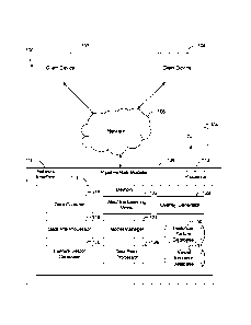
100211 Referring now to FIG. 1, an illustration of an example pipe risk
modeling system
100 is shown, in some embodiments. In brief overview, system 100 can include
two client devices
102 and 104 that communicate with a pipeline risk modeler 106 over a network
108. These
components may operate together to generate an overlay with failure likelihood
data for different
portions of a pipe (e.g., an above ground or underground pipe) in a
geographical region. As
described herein, an underground pipe is a pipe that is located substantially
or fully underground
and an above ground pipe is a pipe that is located substantially or fully
above ground. Such pipes
may be used to transport wastewater and/or potable water. System 100 may
include more, fewer,
or different components than shown in FIG. 1. For example, there may be any
number of client
devices or computers that make up or are a part of pipeline risk modeler 106
or networks in system
100.
100221 Client devices 102 and 104 and/or pipeline risk modeler 106 can
include or execute
on one or more processors or computing devices and/or communicate via network
108. Network
108 can include computer networks such as the Internet, local, wide, metro, or
other area networks,
intranets, satellite networks, and other communication networks such as voice
or data mobile
telephone networks. Network 108 can be used to access information resources
such as web pages,
-6-
8162793
Date Recue/Date Received 2023-01-30
websites, domain names, or uniform resource locators that can be presented,
output, rendered, or
displayed on at least one computing device (e.g., client device 102 or 104),
such as a laptop,
desktop, tablet, personal digital assistant, smartphone, portable computers,
or speaker. For
example, via network 108, client devices 102 and 104 can request, from
pipeline risk modeler 106,
failure likelihood data about pipelines in different geographic regions that
are depicted in aerial
images of the regions.
100231 Each of client devices 102, 104, and/or pipeline risk modeler 106
can include or
utilize at least one processing unit or other logic devices such as a
programmable logic array engine
or a module configured to communicate with one another or other resources or
databases. The
components of client devices 102 and 104 and/or pipeline risk modeler 106 can
be separate
components or a single component. System 100 and its components can include
hardware
elements, such as one or more processors, logic devices, or circuits.
100241 Pipeline risk modeler 106 may comprise one or more processors that
are configured
to generate failure likelihood data for individual portions of a pipe based on
pipe data and
geospatial data. Pipeline risk modeler 106 may comprise a network interface
110, a processor 112,
and/or memory 114. Pipeline risk modeler 106 may communicate with client
devices 102 and 104
via network interface 110. Processor 112 may be or include an ASIC, one or
more FPGAs, a DSP,
circuits containing one or more processing components, circuitry for
supporting a microprocessor,
a group of processing components, or other suitable electronic processing
components. In some
embodiments, processor 112 may execute computer code or modules (e.g.,
executable code, object
code, source code, script code, machine code, etc.) stored in memory 114 to
facilitate the activities
described herein. Memory 114 may be any volatile or non-volatile computer-
readable storage
medium capable of storing data or computer code.
100251 Memory 114 may include a data collector 116, a data pre-processor
118, a feature
vector generator 120, a machine learning model 122, a model manager 124, a
data post-processor
126, an overlay generator 128, a historical failure database 130, and a visual
indicator database
132. In brief overview, components 116-132 may cooperate to collect different
types of data and
images of a geographical region. Components 116-132 may generate a feature
vector from data
and input the feature vector into machine learning model 122, which may have
been trained to
-7-
8162793
Date Recue/Date Received 2023-01-30
output failure likelihood data for individual portions of a pipe. Machine
learning model 122 may
output failure likelihood data for the pipe and components 116-132 may process
the data to
generate one or more overlays with the processed data for display on a
graphical user interface
(GUI) 134. Components 116-132 may place the overlays over an overhead image of
the area in
which the pipe is located and a user may toggle through the different overlays
on the GUI 134 to
view different types of failure likelihood data for the pipe that indicate the
portions of the pipe that
need to be inspected and/or replaced.
100261 Data collector 116 may comprise programmable instructions that,
upon execution,
cause processor 112 to collect geographical data from different sources. For
example, data
collector 116 may receive an image of a geographical area. The image may be an
optical
photograph of the area taken from above the area such as by a satellite or
another flying vehicle.
The area may include a metropolitan region that includes one or more buildings
and/or a forested
region that includes various degrees of vegetation. Data collector 116 may
receive the image of
the area from an entity or company that specializes in capturing and
transmitting such images. For
example, data collector 116 may receive the image from an ESA Sentinel-2
satellite. Additionally,
in some embodiments, data collector 116 may receive photographs or radar data
of the area such
as photographs or radar data collected from ESA Sentinel-1 and/or ALOS-2
PALSAR satellites.
100271 Data collector 116 also receives pipe data for a pipe that is
within the area shown
in the image. The pipe may be an underground or above ground pipe that is
configured to carry
water from a water plant to various destinations, such as to houses or
commercial businesses. The
pipes may transport wastewater and/or potable water. The pipe data may include
data about the
pipe such as, but not limited to, the lengths of segments of the pipe (e.g.,
segments of the pipe that
have been coupled together or segments of the pipe that have been divided by
data collector 116
or the source of the data based on their length and position within the pipe),
the diameter of the
pipe, the age of the pipe, the thickness of the pipe, the material of the
pipe, etc. The pipe data may
be data for individual portions (e.g., segments) of the pipe. Data collector
116 may receive the
pipe data from an online database, the entity that owns the pipe, or from a
data source provider
that collects and maintains records about pipes around the country or world.
-8-
8162793
Date Recue/Date Received 2023-01-30
100281 Data collector 116 receives geospatial data for a geographic region
of the area. The
geographic region may be the geographic area and/or coordinates of the area.
The geospatial data
may include information about the area that is depicted in the image. Examples
of geospatial data
that data collector 116 receives include, but are not limited to, terrain
motion data, vegetation
presence data, soil property data, and terrain slope data.
100291 Terrain motion data may include movement data of the ground surface
(either
subsidence or uplift) measured from a time series of ESA Sentinel 1 radar
imagery. Observed
movement of the ground surface may be a proxy indicator for movement below the
surface that
indicates potential impacts to subsurface infrastructure. Terrain motion data
may include
timeseries data indicating the movement of the surface over time. The terrain
motion data may
include timeseries data captured or determined for various time intervals
depending on the desired
resolution of the data. For example, the timeseries data may include movement
of the terrain
within five-second intervals, ten-second intervals, one-minute intervals, etc.
100301 In some embodiments, data collector 116 divides the pipe data and
geospatial data
into portions to align with the localized measurements of the terrain motion.
For example, data
collector 116 may identify sections of the terrain of the area that move
together. Data collector
116 may identify the portions of the pipe that are closest to the individual
sections of the terrain
(e.g., within a predetermined distance and/or directly under the terrain
section). Data collector 116
may generate and/or assign unique pipe portion identifiers for each of the
identified portions. Data
collector 116 may then assign the pipe data and/or geospatial data to the pipe
portion identifiers
based on the pipe data being associated with (e.g., characterizing) the
portion of the pipe
represented by the unique segment identifier and/or the geospatial data being
associated with an
area within a predetermined distance of the pipe portion of the pipe. Thus,
data collector 116 may
divide the pipe data and geospatial data based on the terrain movement data to
better align with
terrain movement data and account for different variations in likelihood of
failure between the
portions.
100311 Vegetation presence data may include data about the vegetation
(e.g., trees and
bushes) that is in proximity to the pipe. The vegetation presence of the area
around the pipe may
be important because the proximity of large vegetation, such as trees and
bushes, can potentially
-9-
8162793
Date Recue/Date Received 2023-01-30
impact buried pipelines in a variety of ways. For example, the growth and
movement of roots into
pipelines can cause blockages, ruptures, and leakage. The impact of vegetation
may be higher for
unpressurized sewer lines that are more easily penetrated by roots. However,
the growth of roots
can still lead to instability of the subsurface, which can trigger terrain
movement and cause failures
in pressurized or other types of pipes as well. In some cases, the root growth
in temperate climates
is typically in the top 1-2m of soil, so the direct impact to deeper pipelines
may be limited.
100321 In some embodiments, data collector 116 divides the pipe into
portions based on
the vegetation surrounding the different portions of the pipe. For instance,
data collector 116 may
identify regions of the area depicted in the picture that have a significant
amount of vegetation,
such as a forested region, and assign a unique value to that portion of the
pipe and identify a
municipal area with little vegetation and more buildings, and assign a unique
value to the municipal
area. Data collector 116 may do so using object character recognition
techniques on the image.
Data collector 116 may divide the pipe based on variations in the vegetation
that surrounds the
pipe to account for different variations in likelihood of failure between the
portions.
100331 In some embodiments, data collector 116 receives data related to
the soil in which
the pipe is buried or laid. The type of soil where pipe is laid may be
important because certain
materials tend to corrode in particular conditions related to soil pH and
drainage. Soil data are
derived from global open data and include the following sand, silt, and clay
percentages, organic
carbon content, and pH level. Each of these variables may be available at
three depths: 5, 60, and
200 centimeters. Data collector 116 may receive such soil data from data
source providers such
as, but not limited to, the gNATSGO database.
100341 In some embodiments, data collector 116 receives data related to
the slope and/or
elevation of the area in which the pipe is laid. Slope and elevation data may
be important because
pipes laid at an angle are subjected to a differential in hydraulic pressure
that could increase the
probability of ruptures in the pipe. In some embodiments, data collector 116
derives the data for
the slope and/or elevation from an open-source global data set (e.g., USGS
National Elevation
dataset) and calculates the slope and/or elevation from a digital terrain
model (e.g., identify points
in the model and calculate the slope based on the various points on the
model). In some
embodiments, data collector 116 receives raw values for the slope or
elevation. Data collector 116
-10-
8162793
Date Recue/Date Received 2023-01-30
may receive such raw values for individual coordinates, portions of the area
in which the pipe is
located, or for the area as a whole. Data collector 116 may receive the values
from online data
source providers. Data collector 116 may receive any type of other geospatial
data, such as weather
and climate data.
100351 Data pre-processor 118 may comprise programmable instructions that,
upon
execution, cause processor 112 to process the data that data collector 116
receives (e.g., filter out
incomplete or inapplicable data from the data sets). For example, data
collector 116 may receive
an image of a geographical area. Data pre-processor 118 may determine if
geospatial data from
the set of geospatial data is a distance from the pipe below a distance
threshold. The distance
threshold may be a defined threshold stored in memory 114 of pipeline risk
modeler 106. Data
pre-processor 118 may identify the geographical coordinates that correspond to
the individual
pieces of geospatial data (e.g., the coordinates of the vegetation data, the
terrain movement data,
the soil data, and/or the terrain slope data) and the coordinates of the pipe
(e.g., coordinates of
various portions of the pipe). For one data point of the geospatial data
(e.g., geospatial data at set
of coordinates), data pre-processor 118 may determine the distances between
the coordinates for
the data point and the coordinates for different portions of the pipe using a
distance formula. Data
pre-processor 118 may then compare the determined distances to a threshold. If
data pre-processor
118 determines none of the distances are below a threshold, data pre-processor
118 discards the
data point of the geospatial data (e.g., remove the data point from memory 114
or otherwise
exclude the data point from a data set that is being used to generate failure
likelihood data for a
pipe). Data pre-processor 118 may similarly determine whether the data points
of the geospatial
data are within a distance of the pipe below a threshold and discard any data
that is not close to the
pipe. Thus, data pre-processor 118 can filter out the geospatial data that is
likely not relevant to
determining the failure likelihood for the pipe. By doing so, data pre-
processor 118 can minimize
the data that is put into machine learning model 122 while still enabling
machine learning model
122 to generate accurate failure likelihood data.
100361 Data pre-processor 118 may determine if the pipe data for the pipe
is complete. For
example, data pre-processor 118 may store rules that indicate whether pipe
data that the data pre-
processor 118 receives is complete. An example rule may be that data for a
particular portion of
a pipe is complete if the data includes values for the material, diameter, and
age of the portion of
-11-
8162793
Date Recue/Date Received 2023-01-30
the pipe. The rule may also include a requirement that the data include an
identifier indicating
whether the portion of the pipe is active or replaced. The rule may include
requirements that the
data include any type or any number of values. Data pre-processor 118 may
identify the values
(or lack thereof) for each type of pipe data and generate a binary indicator
indicating whether the
data point for the section of the pipe has a value for the data type. Data pre-
processor 118 may
compare the binary values to the rule to determine if the rule is satisfied.
Thus, data pre-processor
118 may determine if the pipe data is complete and avoid using incomplete data
that may skew the
accuracy of failure likelihood data for the portion of the pipe for which
there is incomplete data.
100371 If data pre-processor 118 determines data is missing that is
required by a rule, data
pre-processor 118 may discard the data for the portion of the pipe to which
the geospatial data
corresponds. Data pre-processor 118 may discard the data by removing the data
from memory
114 of pipeline risk modeler 106 or otherwise excluding the data from the
dataset that is being
used to predict failure likelihood data for the pipe. In doing so, data pre-
processor 118 may discard
all the pipe data for the portion of the pipe. Data pre-processor 118 may also
discard the geospatial
data for the portion of the pipe. For example, data pre-processor 118 may
identify any geospatial
data that is within a threshold distance of the portion of the pipe as being
associated with the
portion of the pipe. Data pre-processor 118 may discard the identified
geospatial data responsive
to determining the geospatial data is within the threshold distance of the
portion of the pipe with
incomplete pipe data. Data pre-processor 118 may iteratively evaluate and,
when applicable,
discard geospatial data for each portion of the pipe for which pipeline risk
modeler 106 receives
data.
100381 In some embodiments, before discarding geospatial data for a
portion of the pipe,
data pre-processor 118 may determine if the geospatial data is within the
distance threshold of
another portion of the pipe. For example, if the geospatial data has
coordinates that are within five
meters of multiple defined portions of the pipe, data pre-processor 118 may
determine the
geospatial data will still be used in the dataset with the portions of the
pipe that have or that are
otherwise associated with a complete set of pipe data and that are within the
distance threshold of
the geospatial data. For example, the distance threshold may be five meters.
Data pre-processor
118 may identify geospatial data that is within five meters of multiple
defined portions of the pipe.
Data pre-processor 118 may identify the portions of the pipe for which there
is not a complete set
-12-
8162793
Date Recue/Date Received 2023-01-30
of pipe data and/or geospatial data and the portions of the pipe for which
there is a complete set of
pipe data and/or geospatial data. Because data pre-processor 118 has
identified portions of the
pipe for which there is a complete set of pipe data, data pre-processor 118
may not discard the
associated geospatial data and instead only use the geospatial data for the
portions of the pipe for
which there is a complete set of pipe data.
100391 Feature vector generator 120 may comprise programmable instructions
that, upon
execution, cause processor 112 to generate a feature vector from the pre-
processed pipe and/or
geospatial data. Feature vector generator 120 may segment the data into a
feature vector. Feature
vector generator 120 may segment the data into a feature vector based on the
portions of the pipe
to which the data corresponds. For example, feature vector generator 120 may
identify unique
identifiers of portions (e.g., divided portions) of a pipe. In some
embodiments, feature vector
generator 120 only identifies unique identifiers of portions of the pipe for
which pipe data and/or
geospatial data has not been discarded, as described above. Feature vector
generator 120 may
identify pipe data from a set of pipe data for the pipe that characterizes the
individual portions of
the pipe and assign the pipe data to the unique identifiers for the portions
of the pipe. Similarly,
feature vector generator 120 may identify geospatial data that has coordinates
within a distance
threshold of the different portions of the pipe. Feature vector generator 120
may identify the
unique identifiers for the different portions of the pipe with which the
geospatial data is within a
distance threshold and assign the geospatial data to the unique identifiers of
the portions of the
pipe to which the geospatial data corresponds.
100401 In some embodiments, feature vector generator 120 assigns the pipe
data and the
geospatial data to unique identifiers of segments of a pipe by grouping the
pipe data, the geospatial
data, and the unique identifiers that are assigned together in a feature
vector. For example, feature
vector generator 120 may assign a unique identifier and pipe and geospatial
data to sequential
index values of a feature vector (e.g., the first value of the feature vector
may be the unique
identifier, the second through fifth values may be different pipe data
characteristics, and the sixth
through tenth values may be geospatial characteristics (e.g., variables)).
After adding the data for
one portion of the pipe, feature vector generator 120 may similarly add data
for additional portions
of the pipe in the same or in a similar manner. In this way, feature vector
generator 120 may
-13-
8162793
Date Recue/Date Received 2023-01-30
generate a feature vector such that machine learning model 122 may generate
failure likelihood
data for individual portions of the pipe.
[0041] In some embodiments, if data for an individual portion of the pipe
has been
discarded for having an incomplete set of pipe and/or inapplicable geospatial
data (e.g., geospatial
data that is too far from a portion of the pipe), feature vector generator 120
sets the index values
for the portion of the pipe as null values. Feature vector generator 120 may
do so by setting all
the values to null including the unique identifier for the portion of the pipe
or by including the
unique identifier itself in the feature vector and setting the data for the
portion of the pipe to null.
In some embodiments, feature vector generator 120 excludes all the data for
the portions of the
pipe for which there is incomplete and/or inapplicable data from the feature
vector. Instead, feature
vector generator 120 adds only the portions for which there is complete data.
By doing so, feature
vector generator 120 may avoid making predictions for portions of the pipe for
which there is
incomplete or inapplicable data and/or making predictions for other portions
of the pipe that are
affected by the incomplete or inapplicable data.
[0042] In some embodiments, feature vector generator 120 assigns the pipe
data and the
geospatial data to the unique identifiers in a spreadsheet. For example,
feature vector generator
120 may generate a spreadsheet in which each row includes data for a specific
portion of a pipe
and each column includes data for specific pipe data or geospatial data for
the portions of the pipe.
Feature vector generator 120 may identify the pipe data and the geospatial
data that is associated
with each of the portions of the pipe and insert the identified data into the
rows that correspond to
the portions of the pipe (e.g., feature vector generator 120 may insert pipe
data and geospatial data
for a portion of a pipe into the same row as the unique identifier for the
portion of the pipe). In
some embodiments, feature vector generator 120 inserts data for discarded
portions of the pipe
into the spreadsheet as null values to avoid processing the incomplete or
inapplicable data while
maintaining a record of the portion of the pipe (e.g., include the unique
identifiers for such portions
of the pipe but only add null values for the different columns of the rows).
Feature vector generator
120 may insert the different types of data into the spreadsheet such that the
columns for the pipe
data are next to each other and the columns for the geospatial data are
grouped together after the
columns for the pipe data. This process may be useful to avoid extra
processing that may be caused
by reorganizing the data after the pipe data and geospatial data are input
into pipeline risk modeler
-14-
8162793
Date Recue/Date Received 2023-01-30
106 as separate data sets. The generated spreadsheet may be a feature vector
that can be input into
machine learning model 122 for processing to determine failure likelihood for
different portions
of the pipe.
100431 In some embodiments, feature vector generator 120 generates a
feature vector from
the spreadsheet. For example, feature vector generator 120 may extract values
from the
spreadsheet and concatenate the values to generate a feature vector. In doing
so, feature vector
generator 120 may assign the values for each row to the feature vector
sequentially such that the
values for the portions of the pipe are grouped together to determine the
failure likelihood data for
the different portions of the pipe.
100441 In some embodiments, feature vector generator 120 discards data for
portions for
the pipe for which there is incomplete or inapplicable data prior to adding
the data to the
spreadsheet or avoid using such data to generate failure likelihood data. For
instance, feature
vector generator 120 may insert the data into the different rows of the
spreadsheet after filtering
the incomplete or inapplicable data out of the data set. By doing so, feature
vector generator 120
may avoid inserting incomplete or inapplicable data into machine learning
model 122 when
processing the spreadsheet.
100451 In some embodiments, feature vector generator 120 may include data
for portions
of the pipe for which there is incomplete or inapplicable data in the
spreadsheet, but not use the
data when generating a feature vector. In one example, feature vector
generator 120 may label
portions of the pipe for which there is incomplete or inapplicable data as
discarded in memory 114.
When generating a feature vector from the spreadsheet, feature vector
generator 120 may identify
any rows from the spreadsheet that correspond to a discarded portion of the
pipe (e.g., identify
rows with a unique identifier that matches a unique identifier that is stored
in memory 114 with a
discarded identifier) and skip adding data from the identified rows. In some
embodiments, feature
vector generator 120 may add data for such portions into the feature vector as
null values as
described above. By doing so, feature vector generator 120 may maintain a
record of the data in
the spreadsheet that a user may update with additional data to use for a
future prediction instead
of deleting the data so the data could not be used again.
-15-
8162793
Date Recue/Date Received 2023-01-30
100461 Machine learning model 122 may comprise programmable instructions
that, upon
execution, cause processor 112 to generate failure likelihood data (e.g.,
probabilities that
individual portions of a pipe will experience a failure within a set time
period) for individual
portions of a pipe. Machine learning model 122 may do so based on feature
vectors containing
pipe data of the pipe and geospatial data of the geographic area around the
pipe. Machine learning
model 122 may contain or comprise one or more machine learning models (e.g.,
support vector
machines, neural networks, random forests, regression algorithms such as a
gradient boosting
algorithm, etc.) that can predict failure likelihood data. Machine learning
model 122 may be
configured to receive feature vectors that are generated by feature vector
generator 120 and
determine output failure likelihood data using learned parameters and/or
weights of machine
learning model 122. For example, feature vector generator 120 may execute
machine learning
model 122 using a feature vector comprising concatenated pipe data and
geospatial data for a pipe
and machine learning model 122 may output failure likelihood data for
individually defined
portions of the pipe accordingly.
100471 Model manager 124 may comprise programmable instructions that, upon
execution, cause processor 112 to train or otherwise execute machine learning
model 122. Model
manager 124 may determine if the feature vector that was generated by feature
vector generator
120 is being used to train machine learning model 122. Model manager 124 may
do so by
determining if the data includes any labels that correspond to whether a
failure occurred within the
portions of the pipe. For example, model manager 124 may parse a spreadsheet
to determine if
there is a column for "leak" values (e.g., "leak" or "no leak") that indicates
whether individual
portions of the pipe experienced a leak. If model manager 124 identifies such
a column, model
manager 124 may determine the input feature vector is to be used for training,
otherwise, model
manager 124 may determine the input feature vector is not to be used for
training. In some
embodiments, model manager 124 determines if the feature vector is to be used
for training based
on whether the instructions that model manager 124 is processing include
instructions to train
machine learning model 122 according to labels indicating whether any leaks
occurred in
individual portions of the pipe. In some embodiments, model manager 124
determines the feature
vector is being used to train machine learning model 122 in response to
identifying leak values
-16-
8162793
Date Recue/Date Received 2023-01-30
from the pipe data that model manager 124 receives to make a failure
likelihood prediction (e.g.,
identifying leak values in the data prior to generating a spreadsheet with the
data).
100481 Model manager 124 may label the feature vector responsive to
determining model
manager 124 is training machine learning model 122. Model manager 124 may
label the feature
vector by inserting leak values indicating whether a leak occurred in the
different portions of the
pipe into the feature vector or into a column in a spreadsheet that is
dedicated to such leak values.
Model manager 124 may insert such leak values into a feature vector as a pair
with the values for
the portion of the pipe and/or into the same row as the other values for the
portion of the pipe.
Model manager 124 may insert the leak values into the feature vector or
spreadsheet such that
model manager 124 may later retrieve the values to use to train machine
learning model 122 to
predict failure likelihoods for the individual portions of the pipe.
100491 In some embodiments, model manager 124 only uses data that has been
labeled for
training or otherwise labels a training data set if the failures identified in
the labels satisfy a
criterion stored in memory 114. For example, for a training data set, model
manager 124 may
check historical failure database 130 (e.g., a relational database that stores
a list of failures for
individual portions of different pipes and about and reasons for the
respective failures) to identify
the failures for the portions of the pipe in the data set. Model manager 124
may determine if the
failures have coordinates identifying where the failures occurred or a precise
address (e.g., an
address that can be geocoded such as through an API to a map application) to
generate a pair of
coordinates from the address. Model manager 124 may also identify the cause of
the failure from
historical failure database 130 and determine if the failure was caused by
human intervention or
by environmental factors. Model manager 124 may discard any training data for
portions of the
pipe that indicates a failure occurred in the portion that was caused by human
intervention or where
the address is incomplete (e.g., house number is missing) to ensure the
accuracy of the training
data. Thus, model manager 124 may avoid improperly biasing machine learning
model 122 during
training.
100501 Model manager 124 may execute machine learning model 122. Model
manager
124 may execute machine learning model 122 by inserting the feature vector or
spreadsheet into
machine learning model 122. Upon executing machine learning model 122, model
manager 124
-17-
8162793
Date Recue/Date Received 2023-01-30
may apply the parameters and weights of machine learning model 122 to the
input values. Machine
learning model 122 may output a failure likelihood for each of the portions of
the pipe (e.g., a
likelihood that the respective portion of the pipe will experience a fault,
leak, or other failure within
a set time period (e.g., one year)) for which model manager 124 input data. In
some instances,
model manager 124 retrieves the output failure likelihoods (e.g., failure
likelihood data) for the
different portions of the pipe and trains machine learning model 122 based on
the likelihoods.
100511 To train machine learning model 122 based on the output failure
likelihoods, model
manager 124 may use a backpropagation technique based on the labels for the
different portions
of the pipe. For example, after receiving the output failure likelihoods,
model manager 124 may
compare the output with the expected output (e.g., labels indicating whether a
failure or "leak"
occurred) for the different portions of the pipe. Model manager 124 may then
use a loss function
or another supervised training technique based on the differences between the
two values for the
individual portions of the pipe to train machine learning model 122. Model
manager 124 may use
backpropagation to determine a gradient for the respective loss function and
update the weights
and/or parameters of machine learning model 122 using the gradient, such as by
using gradient
descent techniques.
100521 Model manager 124 may determine if machine learning model 122 has
an accuracy
that exceeds an accuracy threshold. The accuracy threshold may be a defined
threshold that is
stored in memory 114 that may be used to determine if machine learning model
122 is sufficiently
trained to be used to make failure likelihood predictions for new unlabeled
datasets. Model
manager 124 may determine the accuracy of machine learning model 122 by
comparing the output
failure likelihoods for the different portions of the pipe with the leak or
failure label. Model
manager 124 may calculate an average of the differences between the portions
of the pipe and the
labels to determine the accuracy of machine learning model 122. For example,
if the predicted
failure likelihood values for two portions of a pipe were 70 percent and 80
percent and both
portions had a failure or leak label, model manager 124 may determine the
accuracy of machine
learning model 122 was 75 percent by calculating the differences between the
predictions and the
correct value, taking an average of the predictions, and subtracting the
average from the value 1.
If the same set of data had "no leak" or "no failure" labels, however, model
manager 124 may
determine the accuracy of machine learning model 122 was 37.5%. Model manager
124 may
-18-
8162793
Date Recue/Date Received 2023-01-30
compare the determined accuracy to the accuracy threshold. If model manager
124 determines the
accuracy is not above the accuracy threshold, model manager 124 may repeatedly
train machine
learning model 122 until model manager 124 determines machine learning model
122 is
sufficiently trained (e.g., has an accuracy above the accuracy threshold).
100531 If model manager 124 determines the determined accuracy is above
the accuracy
threshold, model manager 124 provisions machine learning model 122. Model
manager 124 may
provision machine learning model 122 by making machine learning model 122
available in a
software-as-a-service environment and/or by transmitting machine learning
model 122 to an entity
requesting machine learning model 122. For example, upon determining machine
learning model
122 is sufficiently trained, model manager 124 may receive requests for
failure likelihood
predictions for different pipes in different regions. Model manager 124 may
receive the requests
with sets of pipe data and/or geospatial data of the regions and predict
failure likelihood data for
the different sections of the pipe with machine learning model 122. Model
manager 124 may
transmit the predicted data back to the requesting device in response to the
request. In
embodiments in which model manager 124 transmits machine learning model 122 to
other devices,
such devices may similarly generate feature vectors and/or spreadsheets with
pipe data and/or
geospatial to make failure likelihood predictions.
100541 In some embodiments, when training machine learning model 122,
model manager
124 may train machine learning model 122 by dividing training data into a
training time period
and a testing time period. For example, model manager 124 may receive pipe
data and geospatial
data for a particular pipe and/or geographic region over four sequential
years. The data may be
divided into four data sets, a data set for each of the four years. The data
for the first three years
may be training data sets and the data for the fourth year may be a test data
set. For example, if a
water company has recorded pipe failure data for a pipe from 2017 to 2020, all
failures recorded
in 2020 would be included in the test data set, while failures recorded from
2017 to 2019 are in the
training data set. The data may include data from the most recent number
(e.g., a predetermined
number) of years for which a water company collected failure data. In some
cases, the test dataset
includes the last year where failures were recorded by a water company, while
the training set
includes the remaining years. The training data and the test data may each
include data for any
number of years and/or any other time period (e.g., day, week, month, etc.)
depending on the time
-19-
8162793
Date Recue/Date Received 2023-01-30
window for which machine learning model 122 generates failure likelihood data
(e.g., if machine
learning model 122 is being trained to predict whether a failure will occur
within a year, model
manager 124 may use year time periods for training while if machine learning
model 122 is being
trained to predict whether a failure will occur within a month, model manager
124 may use month
time periods for training).
100551 In embodiments in which model manager 124 divides data sets into
training and
testing, model manager 124 may train machine learning model 122 using the data
from the training
dataset and then test machine learning model 122 using the testing data set.
For example, if model
manager 124 received separate data sets for a pipe over a four-year period,
model manager 124
may generate a feature vector from the data for each of the four years. Model
manager 124 may
apply labels indicating the correct prediction for a failure likelihood (e.g.,
an indication of whether
a failure occurred in the respective portions of the pipe during the
respective years) to the feature
vectors for the first three years and train machine learning model 122 based
on the three labeled
feature vectors. Model manager 124 may then apply the feature vector for the
testing time period
to machine learning model 122 to obtain failure likelihood predictions for the
testing time period.
Model manager 124 may compare predicted values to the actual values to
determine the current
accuracy of machine learning model 122. Model manager 124 may determine if the
accuracy
exceeds an accuracy threshold by comparing the accuracy to the threshold. In
some embodiments,
if model manager 124 determines the accuracy exceeds the threshold, model
manager 124 may
merge or concatenate the data sets for the four years together (e.g., if the
four years were 2017 to
2020, merge the failure data from the beginning of 2017 to the end of 2020)
and train machine
learning model 122 using all the data. Thus, model manager 124 may fit machine
learning model
122 to the complete data set.
100561 Advantageously, by training machine learning model 122 in this
manner, model
manager 124 may provision machine learning model 122 to predict failures for
individual portions
of pipes over an entire pipe network. Model manager 124 may receive the
failure likelihood
outputs from machine learning model 122, compare the likelihoods to a flag
threshold (e.g., a
predetermined flag threshold), and generate flags for each portion of the pipe
with a failure
likelihood that exceeds the threshold. Thus, model manager 124 may use machine
learning model
122 to predict failures in pipe portions that have not necessarily failed in
the past but are prone to
-20-
8162793
Date Recue/Date Received 2023-01-30
failure because they share one or more characteristics (e.g., physical
characteristics such as
material or age and/or environmental characteristics such as corrosive soil)
with other pipe portions
that have failed in a past observation period.
100571 If model manager 124 determines the data set that was pre-processed
by data pre-
processor 118 is not being used to train machine learning model 122, model
manager 124 executes
machine learning model 122. Model manager 124 may execute machine learning
model 122 by
inputting the spreadsheet or feature vector of pipe and geospatial data into
machine learning model
122. Upon executing machine learning model 122, machine learning model 122 may
output failure
likelihood data for individual portions of the pipe.
100581 Data post-processor 126 may comprise programmable instructions
that, upon
execution, cause processor 112 to determine visual indicators based on failure
likelihood data that
is generated by machine learning model 122. Data post-processor 126 may
determine visual
characteristics for the portions of the pipe. Data post-processor 126 may
determine visual
characteristics of the pipe based on the failure likelihood for the individual
portions. Data post-
processor 126 may determine one or more layers of visual characteristics for
the individual
portions of the pipe based on the portions' respective failure likelihood. In
brief overview, the
different layers may include failure likelihood, priority risk zones,
consequence severity, and/or
criticality of failure.
100591 Data post-processor 126 may select visual indicators for the
failure likelihood layer
based on the predicted failure likelihoods for the individual portions of the
pipe. For example,
data post-processor 126 may store a set of colors that may each correspond to
a different failure
likelihood value in visual indicator database 132 (e.g., a relational database
that stores relationships
between different likelihood of risk values and visual indicators). In some
embodiments, the set
of colors may correspond to a color scale from blue to red with dark blue
corresponding to the
lowest failure likelihood and dark red corresponding to the highest failure
likelihood. Data post-
processor 126 may identify the failure likelihoods for the portions of the
pipe from the output of
machine learning model 122 and use the failure likelihoods as a look-up to
identify the
corresponding colors in visual indicator database 132. Data post-processor 126
may retrieve the
-21-
8162793
Date Recue/Date Received 2023-01-30
colors for the different portions of the pipe based on the colors
corresponding to a matching value
in visual indicator database 132.
[0060] Data post-processor 126 may determine the priority risk zone by
applying a
clustering algorithm to the failure likelihood data. In doing so, data post-
processor 126 may create
management areas based on failure likelihood data for the different portions
of the pipe within the
respective area. Data post-processor 126 may group different portions of a
pipe based on their
proximity to each other and their failure likelihood. Using one example of
such a clustering
algorithm, data post-processor 126 may group different portions of the pipe
together responsive to
the portions being within a defined distance range of each other and/or having
a failure likelihood
within a failure likelihood range. For instance, data post-processor 126 may
create a group of
portions of a pipe that are within 25-meter range of each other and that have
a predicted failure
likelihood between 70% and 80%. Using another example clustering algorithm,
data post-
processor 126 may group portions of a pipe together according to various
spatial and/or hydraulics
rules. For instance, data post-processor 126 may group portions of a pipe
together that have a
predicted failure likelihood above a threshold and/or that are immediately
adjacent to or within a
defined number of pipe portions or within a distance of a pipe portion that is
likely to experience
a failure. Such may be advantageous because if one portion of a pipe
experiences a failure, it may
be more likely that the surrounding portions of the pipe will also experience
a failure or that the
surrounding pipes need to be investigated or replaced to reduce the
possibility of a failure in the
identified portion of the pipe. Using another example clustering algorithm,
data post-processor 126
may identify clusters based on their average failure likelihood exceeding a
threshold. For instance,
data post-processor 126 may identify individual sub-regions of the area of the
pipe that contain
failure likelihood data for portions of the pipe that is above or below the
threshold. Such areas
may be any size.
[0061] Upon clustering the portions of the pipe together, data post-
processor 126 may
select visual indicators for the portions of the pipe based on the clusters.
For instance, data post-
processor 126 may identify a cluster of pipe portions that have or that are
associated with a high
likelihood (e.g., a likelihood above a threshold) of experiencing a failure.
Accordingly, data post-
processor 126 may select a color (e.g., red) that corresponds to having a high
likelihood of
experiencing a failure from visual indicator database 132. Data post-processor
126 may identify
-22-
8162793
Date Recue/Date Received 2023-01-30
a cluster of pipe portions that have a low likelihood of experiencing a
failure. In this case, data
post-processor 126 may select a color (e.g., blue) that corresponds to having
or being associated
with a low likelihood (e.g., a likelihood below a threshold) of experiencing a
failure. Data post-
processor 126 may select any colors based on the characteristics of such a
cluster. Thus, water
companies that view the visual indicators can prioritize investigation and
pipe repair in the areas
of the pipe that are most at risk in their proactive management.
100621 In some embodiments, data post-processor 126 clusters pipe portions
based on the
district metered areas (DMA) in which they are located. To do so, data post-
processor 126 may
identify the pipe portions that are within individual district meter areas
(e.g., identify pipe portions
that have coordinates in different district metered areas or that have a
stored association with
district metered areas) and determine an average of the failure likelihoods
for the different district
metered areas. Data post-processor 126 may compare the average to colors in
visual indicator
database 132 and select the color that corresponds to the average to assign to
each of the pipe
portions in the district metered areas.
100631 Data post-processor 126 may select visual indicators for the
portions of the pipe
based on consequence severities for the individual portions of the pipe.
Consequence severities
may not be dependent on the failure likelihood that is predicted by machine
learning model 122,
but rather may describe the inherent risk that each portion of the pipe poses
to the water company
and the community in case of catastrophic failure. Consequence severity values
may vary between
the entities that request such values. For instance, one entity may only view
risks such as
disruption to the supply of vulnerable customers (e.g., hospitals or schools
in their consequence
severity values) as impacting the consequence severity values. Another entity
may only view risks
such as traffic disruptions as impacting their consequence severity values.
Another entity that
manages the water network in old towns and cities may view pipes running
through the old towns
as more at risk because repairing or replacing these would incur additional
costs. Accordingly,
data post-processor 126 may store different values for the consequence
severities for different
entities for the different pipe portions, geographic locations, and/or
coordinates. Data post-
processor 126 may retrieve the values upon receiving a request for consequence
severity data
and/or other failure likelihood data depending on the entity that is making a
request (e.g., use an
-23-
8162793
Date Recue/Date Received 2023-01-30
identifier of the requesting entity in a look-up to identify the consequence
severity values for the
different portions of the pipe).
100641 In some embodiments, data post-processor 126 determines consequence
severity
values for the different pipe portions. The consequence severity values may be
values between 1
and 100 that indicate the severity of the impact that a failure in the
particular portion of the pipe
would have if it were to experience a failure. Data post-processor 126 may
determine the
consequence severity based on the direct cost of response, repair and
restoration of a break, and/or
the indirect costs of the impact, including the proximity to vulnerable
buildings, service disruption
to customers, collateral damage and/or transport disruption. Data post-
processor 126 may store a
machine learning model that is trained to output consequence severity values
based on such
variables and execute the machine learning model for the individual portions
of the pipe based on
the data. In another example, cost information may not be available to data
post-processor 126.
In such instances, or additionally, data post-processor 126 can execute a
machine learning model
that has been trained to predict consequence severity values for portions of a
pipe using pipe
diameter, historic volume of water loss, and proximity to vulnerable buildings
data (e.g., hospitals
or schools).
100651 Data post-processor 126 may select visual indicators for the
different portions of
the pipe based on the consequence severity values for the different pipe
portions. For example,
data post-processor 126 may store colors that correspond to the different
consequence severity
values similar to the colors for the failure likelihood data in visual
indicator database 132. Data
post-processor 126 may use the consequence severity values in a look-up from
visual indicator
database 132 to identify the colors that correspond to the consequence
severity values for the
different portions of the pipe.
100661 In some embodiments, data post-processor 126 can determine
criticality scores for
the different pipe portions. Data post-processor 126 may do so based on a
combination of the
consequence severity values and failure likelihood values for the individual
portions of the pipe.
For example, for a portion of the pipe, data post-processor 126 may identify
the failure likelihood
and the consequence severity for the portion. Data post-processor 126 may
determine an average,
a weighted average, a multiple, a sum, or any other operation, for the two
values to determine a
-24-
8162793
Date Recue/Date Received 2023-01-30
criticality score for the pipe portion. Data post-processor 126 may similarly
determine criticality
scores for each of the pipe portions for which data post-processor 126
determined a failure
likelihood. Thus, data post-processor 126 may highlight the portions of the
pipe that need to be
inspected or replaced to improve the overall health of the pipe.
100671 Data post-processor 126 may select visual indicators for the
different portions of
the pipe based on the criticality scores for the different pipe portions. For
example, data post-
processor 126 may store colors that correspond to the different criticality
scores similar to the
colors for the failure likelihood data in visual indicator database 132. Data
post-processor 126
may use the criticality scores in a look-up from visual indicator database 132
to identify the colors
that correspond to the criticality scores for the different portions of the
pipe.
100681 Overlay generator 128 may comprise programmable instructions that,
upon
execution, cause processor 112 to generate one or more overlays from the
visual indicators.
Overlay generator 128 may do so by identifying the pixels of the image data
collector 116 received
that correspond to the portions of the pipe for which failure likelihood data
and visual
characteristics were generated. Overlay generator 128 may assign the visual
indicators to the
corresponding pixels and generate an overlay with pixels that mirror the
pixels of the image. In
embodiments in which overlay generator 128 determines visual indicators for
the different layers
(e.g., priority risk zones, consequence severity, and/or criticality of
failure), overlay generator 128
may similarly generate an overlay for each of the layers. Overlay generator
128 may store the
overlays in memory 114 such that the overlays may be retrieved upon receiving
a request from a
client device.
100691 Overlay generator 128 places the overlays over the image. Overlay
generator 128
may place the overlays over the image in response to receiving a request from
a client device (or
in response to the original request requesting an analysis of the pipe data
and geospatial data).
Overlay generator 128 may receive a request to see the overlay for one of the
layers for which
overlay generator 128 determined visual indicators of failure likelihood.
Overlay generator 128
may then place the requested overlay over the image of the area such that the
user can see the
visual indicators over the portions of the pipe and view which portions are
most at risk of
experiencing a failure and/or need to be addressed. A user viewing the user
interface may select
-25-
8162793
Date Recue/Date Received 2023-01-30
an option to view another of the layers. In response to this request, overlay
generator 128 may
remove the initial overlay or visual indicators from the user interface and
place the new requested
overlay over the image, thus toggling between the different visual indicators
and/or overlays to
give the user a broad view of the failure likelihood in different portions of
the pipe. Overlay
generator 128 may toggle between any number of visual indicators or overlays.
100701 Referring now to FIG. 2, a user interface 200 of an overhead view
of a geographic
region illustrating a mapping of the failure likelihoods of various portions
of an underground pipe
of the geographic region is shown, in accordance with some embodiments. For
example, user
interface 200 illustrates a geographic region including a municipal area and a
wooded area within
the geographic region. User interface 200 also illustrates a pipeline that
runs underground in the
geographic region. The pipeline may be outlined (e.g., a line indicating the
location of the pipeline
may be overlaid onto user interface 200) and include visual indicators (e.g.,
color indicators)
indicating the likelihood of failures at different portions of the pipeline. A
data processing system
may determine the visual indicators by executing a machine learning model
using pipe data and
geospatial data for the pipe and region illustrated on user interface 200 as
described herein. By
viewing user interface 200, a user may be able to see the different portions
of the underground
pipe that need to be replaced or inspected before they fail and cause the
piping system to go down
(e.g., the water may need to be turned off to avoid excess leaking). User
interface 200 includes a
key or legend 202 that indicates the visual indicators for the different
failure likelihoods.
100711 Referring now to FIG. 3, a user interface 300 of an overhead view
of a geographic
region illustrating a mapping of the failure likelihoods of various portions
of an underground pipe
of the geographic region determined based on clustered failure likelihoods of
various portions of
the underground pipe is shown, in accordance with some embodiments. Similar to
user interface
200, shown and described with reference to FIG. 2, user interface 300
illustrates a geographic
region including a municipal area and a wooded area. User interface 300 also
illustrates a pipeline
that runs underground in the geographic region. The pipeline may be outlined
and include visual
indicators indicating the likelihood of failures at different portions of the
pipeline. A data
processing system may determine the visual indicators by executing a machine
learning model
using pipe data and geospatial data for the pipe and region. The data
processing system may then
use a clustering algorithm to group the portions of the pipe based on the
likelihood that those
-26-
8162793
Date Recue/Date Received 2023-01-30
portions will experience a failure. For example, the data processing system
may cluster portions
of the pipe together that are within a set geographical distance of each other
and that have failure
likelihoods that are within specific ranges or that have averages within
specific ranges. The data
processing system may select visual indicators for the clusters of the
portions of the pipe and
include the selected visual indicators on user interface 300 to show a user
the general areas that
pipe failures are likely to occur. User interface 300 includes a key or legend
302 that indicates the
visual indicators for the different failure likelihoods.
100721
Referring now to FIG. 4, a user interface 400 of an overhead view of a
geographic
region illustrating a mapping of the consequence severity for various portions
of an underground
pipe in the geographic region is shown, in accordance with some embodiments.
Similar to user
interface 200, shown and described with reference to FIG. 2, user interface
400 illustrates a
geographic region including a municipal area and a wooded area within the
geographic region.
User interface 400 also illustrates a pipeline that runs underground in the
geographic region. The
pipeline may be outlined and include visual indicators indicating the
consequence severity at
different portions of the pipeline. The consequence severity for a specific
portion of the pipe may
indicate how bad the consequences would be if the portions of the pipe failed
(e.g., how expensive
it would be to fix the portion of the pipe if the pipe failed, the
vulnerability of population that
would be affected by the portion of the pipe failing, the likelihood of the
failure affecting traffic,
a combination of such elements, etc.). A data processing system may determine
the visual
indicators by either identifying hardcoded ratings for the different portions
of the pipe or by
determining the consequence severity based on set characteristics of the pipe.
For example, the
data processing system may determine the consequence of a failure for a
portion of the pipe by
determining a weighted average of the costs to fix the failure, the
vulnerability of the population
that would be affected by the failure, and/or the likelihood that the failure
would affect traffic. The
data processing system may similarly determine the consequence severity of a
failure for the other
portions of the pipe. The data processing system may then select visual
indicators (e.g., colors)
that correspond to the calculated consequences and add the visual indicators
to user interface 400
to graphically show the consequence severities of different portions of the
pipe failing. User
interface 400 includes a key or legend 402 that indicates the visual
indicators for the different
consequence severity.
-27-
8162793
Date Recue/Date Received 2023-01-30
100731 Referring now to FIG. 5, a user interface 500 of an overhead view
of a geographic
region illustrating a mapping of the criticality score for various portions of
an underground pipe in
the geographic region is shown, in accordance with some embodiments. Similar
to user interface
200, shown and described with reference to FIG. 2, user interface 500
illustrates a geographic
region including a municipal area and a wooded area within the geographic
region. User interface
500 also illustrates a pipeline that runs underground in the geographic
region. The pipeline may
be outlined and include visual indicators indicating the criticality of
different portions of the
pipeline. The criticality for a specific portion of the pipe may indicate how
critical it is for the
portion of the pipe to be replaced or inspected. A data processing system may
determine criticality
values for the portions of the pipe based on the consequence severity and
failure likelihood for the
portion of the pipe. For example, the data processing system may multiply or
perform another
operation on the consequence severity and failure likelihood values (which may
be determined as
described herein) for the portion of the pipe. The data processing system may
then determine a
visual indicator that corresponds to the criticality value. The data
processing system may similarly
determine criticality values and select visual indicators for other portions
of the pipe that are
illustrated in user interface 500. The data processing system may add the
visual indicators to user
interface 500 to graphically show the criticality of replacing or inspecting
various portions of the
underground pipe. User interface 500 includes a key or legend 502 that
indicates the visual
indicators for the different criticalities.
100741 As described herein, the different user interfaces 200-500
illustrated in FIGS. 2-5
may be or include selectable graphical overlays that a user may request to
view data about the
current state of a pipeline within a geographical region. For example, the
different types of data
that overlay the pipeline shown in user interfaces 200-500 may be selectable
filters that a user may
toggle between while accessing an application (e.g., a remotely hosted
application, such as a
software-as-a-service application) via a computer. If the user wishes to view
the portions of the
pipe that are most likely to experience a failure, the user may select a
button to view user interface
200. If the user wishes to view portions of the pipe that are most critical to
replace, the user may
select a button to view user interface 500. In this way, the application may
provide users with the
ability to see requested data about areas of the pipeline in real-time to
identify where failures are
likely to occur in the future. Thus, the application may reduce the need for
users to employ any
-28-
8162793
Date Recue/Date Received 2023-01-30
surveyors that rely on leak detection devices to detect failures that have
already occurred because
any of such leaks will have been addressed before they could occur.
100751
Referring now to FIG. 6, an example of a training data set 600 for training a
machine learning model to generate failure likelihood data is shown, in
accordance with some
embodiments. As illustrated, training data set 600 may include columns for the
different types of
data that can be input into a machine learning model to obtain failure
likelihood data for individual
portions of an underground pipe. Training data set 600 may include a column
602 that includes
identifications of individual portions or segments of an underground pipe.
Each portion may have
an individual identifier such that the data for the portion of the pipe is in
the same row as the
identifier in other columns of training data set 600. Each row of training
data set 600 may
correspond or include data for a different portion of the pipe. Each portion
of the pipe may
correspond to one or more pixels of an image of the area in which the pipe is
located. Training
data set 600 may also include pipe data in columns 604a-e and 604g-h. Columns
604a and 604b
may include values indicating the lengths of the individual portions of the
pipe. Columns 604c
and 604d may include values for the age and material of the individual
portions of the pipe.
Column 604e may include values for the diameter of the individual portions of
the pipe. Columns
604g and 604h may include values indicating which portions of the pipe have
experienced a leak
or a failure within a set time period. Columns 604g and 604h may be label
columns indicating the
correct failure predictions for the different portions of the underground
pipe. Training data set 600
may include columns 604f and 604i-604q which include various geospatial data
(e.g., terrain
motion data (e.g., timeseri es data), vegetation presence data, soil property
data, and/or terrain slope
data) for locations that are above and/or within a set radius of the
respective portion of the
underground pipe (e.g., the values for the geospati al data may characterize
the portions of pipe that
have unique identifiers in the same rows as the respective geospatial data). A
data processing
system (e.g., pipeline risk modeler 106) may generate a feature vector of the
pipe data of columns
602-604e as well as the geospatial data of columns 604f and 604i-604q and use
the feature vector
as an input into a machine learning model to obtain predictions for
likelihoods of failures occurring
in different portions of the underground pipe. The data processing system may
compare the
predicted likelihoods to the corresponding leak or failure values of columns
604g and/or 604h,
determine differences between the predictions and the actual values, and train
the machine learning
-29-
8162793
Date Recue/Date Received 2023-01-30
model based on the differences. Accordingly, the data processing system may
use training data
set 600 to train the machine learning model to predict failures or leaks of
different sections of an
underground pipe.
100761
Referring now to FIG. 7, an example method 700 for improved pipe risk modeling
is shown, in accordance with some embodiments. Method 700 can be performed by
a data
processing system (e.g., a client device 102 or 104 or a pipeline risk modeler
106, shown and
described with reference to FIG. 1, a server system, etc.). Method 700 may
include more or fewer
operations and the operations may be performed in any order. Performance of
method 700 may
enable the data processing system to generate failure likelihood data
indicating the likelihood that
individual portions or segments of a pipe within a geographical region will
experience a failure
(e.g., a likelihood that individual portions or segments of the pipe will
experience a failure within
a set time period). The data processing system may collect pipe data about
individual portions or
segments of a pipe that is within such a geographical region. Pipe data may
include segment
length, pipe diameter, pipe age, pipe material, etc. The data processing
system may also collect
geospatial data of the area surrounding the pipe. Geospatial data may include
terrain motion,
vegetation presence, soil properties, terrain slope, climate, weather,
elevation, etc. The data
processing system may segment the data into data that corresponds to
individual portions of the
pipe and concatenate the segmented data into a feature vector. The data
processing system may
then input the feature vector into a machine learning model to generate
failure likelihood data (e.g.,
a probability that a failure or leak will occur) for each of the portions of
the pipe. The data
processing system may then generate an overlay with the failure likelihood
data to overlay onto an
image of the region such that a user may view which portions of the pipe are
likely to fail within
a defined time period (e.g., within a time period for which the machine
learning model is trained
to predict failure likelihood data) and thus need to be inspected and/or
replaced. By segmenting
the pipe data and geospatial data into segments based on the portions of the
pipe to which the
respective data corresponds, the machine learning model may accurately predict
failure likelihood
data for each portion of the pipe. Thus, the machine learning model may
predict failure likelihood
data that a user can use to address specific portions of the pipe instead of
simply knowing a failure
is likely to occur in the pipe in general.
-30-
8162793
Date Recue/Date Received 2023-01-30
100771 At operation 702, the data processing system receives an image of a
geographical
area. The image may be an optical photograph of the area taken from above the
area such as by a
satellite or another flying vehicle. The area may include a metropolitan
region that includes one
or more buildings and/or a forested region that includes various degrees of
vegetation. The data
processing system may receive the image of the area from an entity or company
that specializes in
capturing and transmitting such images. For example, the data processing
system may receive the
image from an ESA Sentinel-2 satellite. Additionally, in some embodiments, the
data processing
system may receive photographs or radar data of the area such as photographs
or radar data
collected from ESA Sentinel-1 and/or ALOS-2 PALSAR satellites.
100781 The data processing system also receives pipe data for a pipe that
is within the area
shown in the image. The pipe may be an underground or above ground pipe. The
pipe may be
configured to carry water from a water plant to various destinations, such as
to houses or
commercial businesses. The pipe may transport wastewater and/or potable water.
The data
processing system may receive the image and the pipe data with a request for
failure likelihood
data for the pipe. The pipe data may include data about the pipe such as, but
not limited to, the
lengths of segments of the pipe (e.g., segments of the pipe that have been
coupled together or
segments of the pipe that have been divided by the data processing system or
the source of the data
based on their length and position within the pipe), the diameter of the pipe,
the age of the pipe,
the thickness of the pipe, the material of the pipe, etc. The pipe data may be
data for individual
portions (e.g., segments) of the pipe. The data processing system may receive
the pipe data from
an online database, the entity that owns the pipe, or from a data source
provider that collects and
maintains records about pipes around the country or world.
100791 At operation 704, the data processing system receives geospatial
data for a
geographic region of the area. The geographic region may be the geographic
area and/or
coordinates of the area. The geospatial data may include information about the
area that is depicted
in the image. Examples of geospatial data that the data processing system
receives include, but
are not limited to, terrain motion data, vegetation presence data, soil
property data, and terrain
slope data.
-31 -
8162793
Date Recue/Date Received 2023-01-30
100801 At operation 706, the data processing system determines if
geospatial data from the
set of geospatial data is a distance from the pipe below a distance threshold.
The distance threshold
may be a defined threshold stored in memory of the data processing system. The
data processing
system may identify the geographical coordinates that correspond to the
individual pieces of
geospatial data (e.g., the coordinates of the vegetation data, the terrain
movement data, the soil
data, and/or the terrain slope data) and the coordinates of the pipe (e.g.,
coordinates of various
portions of the pipe). For one data point of the geospatial data (e.g.,
geospatial data at set of
coordinates), the data processing system may determine the distances between
the coordinates for
the data point and the coordinates for different portions of the pipe using a
distance formula. The
data processing system may then compare the determined distances to a
threshold. If the data
processing system determines none of the distances are below a threshold, at
operation 708, the
data processing system discards the data point of the geospatial data (e.g.,
remove the data point
from memory or otherwise exclude the data point from a data set that is being
used to generate
failure likelihood data for a pipe). The data processing system may similarly
determine whether
the data points of the geospatial data are within a distance of the pipe below
a threshold and discard
any data that is not close to the pipe. Thus, the data processing system can
filter out the geospatial
data that is likely not relevant to determining the failure likelihood for the
pipe. By doing so, the
data processing system can minimize the data that is put into a machine
learning model while still
enabling the machine learning model to generate accurate failure likelihood
data.
100811 At operation 710, the data processing system determines if the pipe
data for the pipe
is complete. For example, the data processing system may store rules that
indicate whether pipe
data that the data processing system receives is complete. An example rule may
be that data for a
particular portion of a pipe is complete if the data includes values for the
material, diameter, and
age of the portion of the pipe. The rule may also include a requirement that
the data include an
identifier indicating whether the portion of the pipe is active or replaced.
The rule may include
requirements that the data include any type or any number of values. The data
processing system
may identify the values (or lack thereof) for each type of pipe data and
generate a binary indicator
indicating whether the data point for the section of the pipe has a value for
the data type. The data
processing system may compare the binary values to the rule to determine if
the rule is satisfied.
Thus, the data processing system may determine if the pipe data is complete
and avoid using
-32-
8162793
Date Recue/Date Received 2023-01-30
incomplete data that may skew the accuracy of failure likelihood data for the
portion of the pipe
for which there is incomplete data.
100821 If the data processing system determines data is missing that is
required by a rule,
at operation 712, the data processing system discards the data for the portion
of the pipe to which
the geospatial data corresponds. The data processing system may discard the
data by removing
the data from memory of the data processing system or otherwise excluding the
data from the
dataset that is being used to predict failure likelihood data for the pipe. In
doing so, the data
processing system may discard all of the pipe data for the portion of the
pipe. The data processing
system may also discard the geospatial data for the portion of the pipe. For
example, the data
processing system may identify any geospatial data that is within a threshold
distance of the portion
of the pipe as being associated with the portion of the pipe. The data
processing system may
discard the identified geospatial data responsive to determining the
geospatial data is within the
threshold distance of the portion of the pipe with incomplete pipe data. The
data processing system
may iteratively repeat operations 710 and 712 for each portion of the pipe for
which the data
processing system receives data.
100831 In some embodiments, before discarding geospatial data for a
portion of the pipe,
the data processing system may determine if the geospatial data is within the
distance threshold of
another portion of the pipe. For example, if the geospatial data has
coordinates that are within five
meters of multiple defined portions of the pipe, the data processing system
may determine the
geospatial data will still be used in the dataset with the portions of the
pipe that have or that are
otherwise associated with a complete set of pipe data and that are within the
distance threshold of
the geospatial data. For example, the distance threshold may be five meters.
The data processing
system may identify geospatial data that is within five meters of multiple
defined portions of the
pipe. The data processing system may identify the portions of the pipe for
which there is not a
complete set of pipe data and/or geospatial data and the portions of the pipe
for which there is a
complete set of pipe data and/or geospatial data. Because the data processing
system has identified
portions of the pipe for which there is a complete set of pipe data, the data
processing system may
not discard the associated geospatial data and instead only use the geospatial
data for the portions
of the pipe for which there is a complete set of pipe data.
-33-
8162793
Date Recue/Date Received 2023-01-30
100841 At operation 714, the data processing system segments the data into
a feature
vector. The data processing system may segment the data into a feature vector
based on the
portions of the pipe to which the data corresponds. For example, the data
processing system may
identify unique identifiers of portions (e.g., divided portions) of a pipe. In
some embodiments, the
data processing system only identifies unique identifiers of portions of the
pipe for which pipe data
and/or geospatial data has not been discarded, as described above. The data
processing system
may identify pipe data from a set of pipe data for the pipe that characterizes
the individual portions
of the pipe and assign the pipe data to the unique identifiers for the
portions of the pipe. Similarly,
the data processing system may identify geospatial data that has coordinates
within a distance
threshold of the different portions of the pipe. The data processing system
may identify the unique
identifiers for the different portions of the pipe with which the geospatial
data is within a distance
threshold and assign the geospatial data to the unique identifiers of the
portions of the pipe to
which the geospatial data corresponds.
100851 In some embodiments, the data processing system assigns the pipe
data and the
geospatial data to unique identifiers of segments of a pipe by grouping the
pipe data, the geospatial
data, and the unique identifiers that are assigned together in a feature
vector. For example, the
data processing system may assign a unique identifier and pipe and geospatial
data to sequential
index values of a feature vector (e.g., the first value of the feature vector
may be the unique
identifier, the second through fifth values may be different pipe data
characteristics, and the sixth
through tenth values may be geospatial characteristics (e.g., variables)).
After adding the data for
one portion of the pipe, the data processing system may similarly add data for
additional portions
of the pipe in the same or in a similar manner. In this way, the data
processing system may generate
a feature vector such that a machine learning model may generate failure
likelihood data for
individual portions of the pipe.
100861 In some embodiments, if data for an individual portion of the pipe
has been
discarded for having an incomplete set of pipes and/or inapplicable geospatial
data (e.g., geospatial
data that is too far from a portion of the pipe), the data processing system
sets the index values for
the portion of the pipe as null values. The data processing system may do so
by setting all of the
values to null including the unique identifier for the portion of the pipe or
by including the unique
identifier itself in the feature vector and setting the data for the portion
of the pipe to null. In some
-34-
8162793
Date Recue/Date Received 2023-01-30
embodiments, the data processing system excludes all of the data for the
portions of the pipe for
which there is incomplete and/or inapplicable data from the feature vector.
Instead, the data
processing system adds only the portions for which there is complete data. By
doing so, the data
processing system may avoid making predictions for portions of the pipe for
which there is
incomplete or inapplicable data and/or making predictions for other portions
of the pipe that are
affected by the incomplete or inapplicable data.
100871 In some embodiments, the data processing system assigns the pipe
data and the
geospatial data to the unique identifiers in a spreadsheet. For example, the
data processing system
may generate a spreadsheet in which each row includes data for a specific
portion of a pipe and
each column includes data for specific pipe data or geospatial data for the
portions of the pipe.
The data processing system may identify the pipe data and the geospatial data
that is associated
with each of the portions of the pipe and insert the identified data into the
rows that correspond to
the portions of the pipe (e.g., the data processing system may insert pipe
data and geospatial data
for a portion of a pipe into the same row as the unique identifier for the
portion of the pipe). In
some embodiments, the data processing system inserts data for discarded
portions of the pipe into
the spreadsheet as null values to avoid processing the incomplete or
inapplicable data while
maintaining a record of the portion of the pipe (e.g., include the unique
identifiers for such portions
of the pipe but only add null values for the different columns of the rows).
The data processing
system may insert the different types of data into the spreadsheet such that
the columns for the
pipe data are next to each other and the columns for the geospatial data are
grouped together after
the columns for the pipe data. This may be useful to avoid extra processing
that may be caused
by reorganizing the data after the pipe data and geospatial data are input
into the data processing
system as separate data sets. The generated spreadsheet may be a feature
vector that can be input
into a machine learning model for processing to determine failure likelihood
for different portions
of the pipe.
100881 In some embodiments, the data processing system generates a feature
vector from
the spreadsheet. For example, the data processing system may extract values
from the spreadsheet
and concatenate the values to generate a feature vector. In doing so, the data
processing system
may assign the values for each row to the feature vector sequentially such
that the values for the
-35-
8162793
Date Recue/Date Received 2023-01-30
portions of the pipe are grouped together to determine the failure likelihood
data for the different
portions of the pipe.
[0089] In some embodiments, the data processing system discards data for
portions for the
pipe for which there is incomplete or inapplicable data prior to adding the
data to the spreadsheet
or avoid using such data to generate failure likelihood data. For instance,
the data processing
system may insert the data into the different rows of the spreadsheet after
filtering the incomplete
or inapplicable data out of the data set. By doing so, the data processing
system may avoid
inserting incomplete or inapplicable data into the machine learning model when
processing the
spreadsheet.
[0090] In some embodiments, the data processing system may include data
for portions of
the pipe for which there is incomplete or inapplicable data in the
spreadsheet, but not use the data
when generating a feature vector. In one example, the data processing system
may label portions
of the pipe for which there is incomplete or inapplicable data as discarded in
memory. When
generating a feature vector from the spreadsheet, the data processing system
may identify any rows
from the spreadsheet that correspond to a discarded portion of the pipe (e.g.,
identify rows with a
unique identifier that matches a unique identifier that is stored in memory
with a discarded
identifier) and skip adding data from the identified rows. In some
embodiments, the data
processing system may add data for such portions into the feature vector as
null values as described
above. By doing so, the data processing system may maintain a record of the
data in the
spreadsheet that a user may update with additional data to use for a future
prediction instead of
deleting the data so the data could not be used again.
[0091] At operation 716, the data processing system determines if the
feature vector is
being used to train the machine learning model. The data processing system may
do so by
determining if the data includes any labels that correspond to whether a
failure occurred within the
portions of the pipe. For example, the data processing system may parse a
spreadsheet to determine
if there is a column for "leak" values (e.g., "leak" or "no leak") that
indicates whether individual
portions of the pipe experienced a leak. If the data processing system
identifies such a column,
the data processing system may determine the input feature vector is to be
used for training,
otherwise, the data processing system may determine the input feature vector
is not to be used for
-36-
8162793
Date Recue/Date Received 2023-01-30
training. In some embodiments, the data processing system determines if the
feature vector is to
be used for training based on whether the instructions that the data
processing system is processing
include instructions to train the machine learning model according to labels
indicating whether any
leaks occurred in individual portions of the pipe. In some embodiments, the
data processing
system determines the feature vector is being used to train the machine
learning model in response
to identifying leak values from the pipe data that the data processing system
receives to make a
failure likelihood prediction (e.g., identifying leak values in the data prior
to generating a
spreadsheet with the data).
100921 At operation 718, the data processing system labels the feature
vector responsive to
determining the data processing system is training a machine learning model.
The data processing
system may label the feature vector by inserting leak values indicating
whether a leak occurred in
the different portions of the pipe into the feature vector or into a column in
a spreadsheet that is
dedicated to such leak values. The data processing system may insert such leak
values into a
feature vector as a pair with the values for the portion of the pipe and/or
into the same row as the
other values for the portion of the pipe. The data processing system may
insert the leak values
into the feature vector or spreadsheet such that the data processing system
may later retrieve the
values to use to train the machine learning model to predict failure
likelihoods for the individual
portions of the pipe.
100931 In some embodiments, the data processing system only uses data that
has been
labeled for training or otherwise labels a training data set if the failures
identified in the labels
satisfy a criterion stored in the data processing system. For example, for a
training data set, the
data processing system may check a historical failure database to identify the
failures for the
portions of the pipe in the data set. The data processing system may determine
if the failures have
coordinates identifying where the failures occurred or a precise address
(e.g., an address that can
be geocoded such as through an API to a map application) to generate a pair of
coordinates from
the address. The data processing system may also identify the cause of the
failure from the
database and determine if the failure was caused by human intervention or by
environmental
factors. The data processing system may discard any training data for portions
of the pipe that
indicates a failure occurred in the portion that was caused by human
intervention or where the
address is incomplete (e.g., house number is missing) to ensure the accuracy
of the training data.
-37-
8162793
Date Recue/Date Received 2023-01-30
Thus, the data processing system may avoid improperly biasing the machine
learning model during
training.
100941 At operation 720, the data processing system executes the machine
learning model.
The machine learning model may be any type of machine learning model (e.g., a
neural network,
a support vector machine, random forest, a regression algorithm such as a
gradient boosting
algorithm, etc.). The data processing system may execute the machine learning
model by inserting
the feature vector or spreadsheet into the machine learning model. Upon
executing the machine
learning model, the data processing system may apply the parameters and
weights of the machine
learning model to the input values. The machine learning model may output a
failure likelihood
for each of the portions of the pipe (e.g., a likelihood that the respective
portion of the pipe will
experience a fault, leak, or other failure within a set time period (e.g., one
year)) for which the data
processing system input data. The data processing system may retrieve the
output failure
likelihoods for the different portions of the pipe and train the machine
learning model based on the
likelihoods.
100951 To train the machine learning model based on the output failure
likelihoods, the
data processing system may use a backpropagati on technique based on the
labels for the different
portions of the pipe. For example, after receiving the output failure
likelihoods, the data processing
system may compare the output with the expected output (e.g., labels
indicating whether a failure
or "leak" occurred) for the different portions of the pipe. The data
processing system may then
use a loss function or another supervised training technique based on the
differences between the
two values for the individual portions of the pipe to train the machine
learning model. The data
processing system may use backpropagation to determine a gradient for the
respective loss
function and update the weights and/or parameters of the machine learning
model using the
gradient, such as by using gradient descent techniques.
100961 At operation 722, the data processing system determines if the
machine learning
model has an accuracy that exceeds an accuracy threshold. The accuracy
threshold may be a
defined threshold that is stored in memory of the data processing system that
may be used to
determine if machine learning models are sufficiently trained to be used to
make failure likelihood
predictions for new unlabeled datasets. The data processing system may
determine the accuracy
-38-
8162793
Date Recue/Date Received 2023-01-30
of the machine learning model by comparing the output failure likelihoods for
the different
portions of the pipe with the leak or failure label. The data processing
system may calculate an
average of the differences between the portions of the pipe and the labels to
determine the accuracy
of the machine learning model. For example, if the predicted failure
likelihood values for two
portions of a pipe were 70 percent and 80 percent and both portions had a
failure or leak label, the
data processing system may determine the accuracy of the machine learning
model was 75 percent
by calculating the differences between the predictions and the correct value,
taking an average of
the predictions, and subtracting the average from the value 1. If the same set
of data had "no leak"
or "no failure" labels, however, the data processing system may determine the
accuracy of the
machine learning model was 37.5%. The data processing system may compare the
determined
accuracy to the accuracy threshold. If the data processing system determines
the accuracy is not
above the accuracy threshold, the data processing system may repeat operations
702-722 until the
data processing system determines the machine learning model is sufficiently
trained (e.g., has an
accuracy above the accuracy threshold).
100971 If the data processing system determines the determined accuracy is
above the
accuracy threshold, at operation 724, the data processing system provisions
the machine learning
model. The data processing system may provision the machine learning model by
making the
machine learning model available in a software-as-a-service environment and/or
by transmitting
the machine learning model to an entity requesting the machine learning model.
For example,
upon determining the machine learning model is sufficiently trained, the data
processing system
may receive requests for failure likelihood predictions for different pipes in
different regions. The
data processing system may receive the requests with sets of pipe data and/or
geospatial data of
the regions and predict failure likelihood data for the different sections of
the pipe with the machine
learning model. The data processing system may transmit the predicted data
back to the requesting
device in response to the request. In embodiments in which the data processing
system transmits
the machine learning model to other devices, such devices may similarly
generate feature vectors
and/or spreadsheets with pipe data and/or geospatial to make failure
likelihood predictions.
100981 In some embodiments, when training the machine learning model, the
data
processing system may train the machine learning model by dividing training
data into a training
time period and a testing time period. For example, the data processing system
may receive pipe
-39-
8162793
Date Recue/Date Received 2023-01-30
data and geospatial data for a particular pipe and/or geographic region over
four sequential years.
The data may be divided into four data sets, a data set for each of the four
years. The data for the
first three years may be training data sets and the data for the fourth year
may be a test data set.
For example, if a water company has recorded pipe failure data for a pipe from
2017 to 2020, all
failures recorded in 2020 would be included in the test data set, while
failures recorded from 2017
to 2019 are in the training data set. The data may include data from the most
recent number (e.g.,
a predetermined number) of years for which a water company collected failure
data. In some
cases, the test dataset includes the last year where failures were recorded by
a water company,
while the training set includes the remaining years. The training data and the
test data may each
include data for any number of years and/or any other time period (e.g., day,
week, month, etc.).
100991
In embodiments in which the data processing system divides data sets into
training
and testing, the data processing system may train the machine learning model
using the data from
the training dataset and then test the machine learning model using the
testing data set. For
example, if the data processing system received separate data sets for a pipe
over a four-year
period, the data processing system may generate a feature vector from the data
for each of the four
years. The data processing system may apply labels indicating the correct
prediction for a failure
likelihood (e.g., an indication of whether a failure occurred in the
respective portions of the pipe
during the respective years) to the feature vectors for the first three years
and train the machine
learning model based on the three labeled feature vectors. The data processing
system may then
apply the feature vector for the testing time period to the machine learning
model to obtain failure
likelihood predictions for the testing time period. The data processing system
may compare
predicted values to the actual values to determine the current accuracy of the
machine learning
model. The data processing system may determine if the accuracy exceeds an
accuracy threshold
by comparing the accuracy to the threshold. In some embodiments, if the data
processing system
determines the accuracy exceeds the threshold, the data processing system may
merge or
concatenate the data sets for the four years together (e.g., if the four years
were 2017 to 2020,
merge the failure data from the beginning of 2017 to the end of 2020) and
train the machine
learning model using all of the data. Thus, the data processing system may fit
the machine learning
model to the complete data set.
-40-
8162793
Date Recue/Date Received 2023-01-30
101001 Advantageously, by training the machine learning model in this
manner, the data
processing system may provision the machine learning model to predict failures
for individual
portions of pipes over an entire pipe network. The data processing system may
receive the failure
likelihood outputs from the machine learning model, compare the likelihoods to
a flag threshold
(e.g., a predetermined flag threshold), and generate flags for each portion of
the pipe with a failure
likelihood that exceeds the threshold. Thus, the data processing system may
use the machine
learning model to predict failures in pipe portions that have not necessarily
failed in the past but
are prone to failure because they share one or more characteristics (e.g.,
physical characteristics
such as material or age and/or environmental characteristics such as corrosive
soil) with other pipe
portions that have failed in a past observation period.
101011 Returning to operation 716, if the data processing system
determines the data set is
not being used to train the machine learning model, at operation 726, the data
processing system
executes the machine learning model. The data processing system may execute
the machine
learning model by inputting the spreadsheet or feature vector of pipe and
geospatial data into the
machine learning model. Upon executing the machine learning model, the machine
learning model
may output failure likelihood data for individual portions of the pipe. In
some embodiments, upon
generating the failure likelihood data, the data processing system transmit
the failure likelihood
data to a device that requests failure likelihood data for the region or that
sent a request to cause
the data processing system to generate the failure likelihood data.
101021 At operation 728, the data processing system determines visual
characteristics for
the portions of the pipe. The data processing system may determine visual
characteristics of the
pipe based on the failure likelihood for the individual portions. The data
processing system may
determine one or more layers of visual characteristics for the individual
portions of the pipe based
on the portions' respective failure likelihood. In brief overview, the
different layers may include
failure likelihood, priority risk zones, consequence severity, and/or
criticality of failure.
101031 The data processing system may select visual indicators for the
failure likelihood
layer based on the predicted failure likelihoods for the individual portions
of the pipe. For
example, the data processing system may store a set of colors that may each
correspond to a
different failure likelihood value in memory. In some embodiments, the set of
colors may
-41-
8162793
Date Recue/Date Received 2023-01-30
correspond to a color scale from blue to red with dark blue corresponding to
the lowest failure
likelihood and dark red corresponding to the highest failure likelihood. The
data processing system
may identify the failure likelihoods for the portions of the pipe from the
output of the machine
learning model and use the failure likelihoods as a look-up to identify the
corresponding colors in
memory. The data processing system may retrieve the colors for the different
portions of the pipe
based on the colors corresponding to a matching value in memory.
101041 The data processing system may determine the priority risk zone by
applying a
clustering algorithm to the failure likelihood data. In doing so, the data
processing system may
create management areas based on failure likelihood data for the different
portions of the pipe
within the respective area. The data processing system may group different
portions of a pipe
based on their proximity to each other and their failure likelihood. Using one
example of such a
clustering algorithm, the data processing system may group different portions
of the pipe together
responsive to the portions being within a defined distance range of each other
and/or having a
failure likelihood within a failure likelihood range. For instance, the data
processing system may
create a group of portions of a pipe that are within 25-meter range of each
other and that have a
predicted failure likelihood between 70% and 80%. Using another example
clustering algorithm,
the data processing system may group portions of a pipe together according to
various spatial
and/or hydraulics rules. For instance, the data processing system may group
portions of a pipe
together that either have a predicted failure likelihood above a threshold or
that are immediately
adjacent to or within a defined number of pipe portions or within a distance
of a pipe portion that
is likely to experience a failure. Such may be advantageous because if one
portion of a pipe
experiences a failure, it may be more likely that the surrounding portions of
the pipe will also
experience a failure or that the surrounding pipes need to be investigated or
replaced to reduce the
possibility of a failure in the identified portion of the pipe. Using another
example clustering
algorithm, the data processing system may identify clusters based on their
average failure
likelihood exceeding a threshold. For instance, the data processing system may
identify individual
sub-regions of the area of the pipe that contain failure likelihood data for
portions of the pipe that
is above or below the threshold. Such areas may be any size.
101051 Upon clustering the portions of the pipe together, the data
processing system may
select visual indicators for the portions of the pipe based on the clusters.
For instance, the data
-42-
8162793
Date Recue/Date Received 2023-01-30
processing system may identify a cluster of pipe portions that have or that
are associated with a
high likelihood (e.g., a likelihood above a threshold) of experiencing a
failure. Accordingly, the
data processing system may select a color (e.g., red) that corresponds to
having a high likelihood
of experiencing a failure from memory. The data processing system may identify
a cluster of pipe
portions that have a low likelihood of experiencing a failure. In this case,
the data processing
system may select a color (e.g., blue) that corresponds to having or being
associated with a low
likelihood (e.g., a likelihood below a threshold) of experiencing a failure.
The data processing
system may select any colors based on the characteristics of such a cluster.
Thus, water companies
that view the visual indicators can prioritize investigation and pipe repair
in the areas of the pipe
that are most at risk in their proactive management.
101061 In some embodiments, the data processing system clusters pipe
portions based on
the district metered areas (DMA) in which they are located. To do so, the data
processing system
may identify the pipe portions that are within individual district meter areas
(e.g., identify pipe
portions that have coordinates in different district metered areas or that
have a stored association
with district metered areas) and determine an average of the failure
likelihoods for the different
district metered areas. The data processing system may compare the average to
colors in a database
and select the color that corresponds to the average to assign to each of the
pipe portions in the
district metered areas.
101071 The data processing system may select visual indicators for the
portions of the pipe
based on consequence severities for the individual portions of the pipe.
Consequence severities
may not be dependent on the failure likelihood that is predicted by the
machine learning model,
but rather may describe the inherent risk that each portion of the pipe poses
to the water company
and the community in case of catastrophic failure. Consequence severity values
may vary between
the entities that request such values. For instance, one entity may only view
risks such as
disruption to the supply of vulnerable customers (e.g., hospitals or schools
in their consequence
severity values) as impacting the consequence severity values. Another entity
may only view risks
such as traffic disruptions as impacting the consequence severity values.
Another entity that
manages the water network in old towns and cities may view pipes running
through the old towns
as more at risk because repairing or replacing these would incur additional
costs. Accordingly,
the data processing system may store different values for the consequence
severities for different
-43-
8162793
Date Recue/Date Received 2023-01-30
entities for the different pipe portions, geographic locations, and/or
coordinates. The data
processing system may retrieve the values upon receiving a request for
consequence severity data
and/or other failure likelihood data depending on the entity that is making a
request (e.g., use an
identifier of the requesting entity in a look-up to identify the consequence
severity values for the
different portions of the pipe).
101081 In some embodiments, the data processing system determines
consequence severity
values for the different pipe portions. The consequence severity values may be
values between 1
and 100 that indicate the severity of the impact that a failure in the
particular portion of the pipe
would have if it were to experience a failure. The data processing system may
determine the
consequence severity based on the direct cost of response, repair and
restoration of a break, and/or
the indirect costs of the impact, including the proximity to vulnerable
buildings, service disruption
to customers, collateral damage and/or transport disruption. The data
processing system may store
a machine learning model that is trained to output consequence severity values
based on such
variables and execute the machine learning model for the individual portions
of the pipe based on
the data. In another example, cost information may not be available to the
data processing system.
In such instances, or additionally, the data processing system can execute a
machine learning
model that has been trained to predict consequence severity values for
portions of a pipe using
pipe diameter, historic volume of water loss, and proximity to vulnerable
buildings data (e.g.,
hospitals or schools).
101091 The data processing system may select visual indicators for the
different portions
of the pipe based on the consequence severity values for the different pipe
portions. For example,
the data processing system may store colors that correspond to the different
consequence severity
values similar to the colors for the failure likelihood data in memory. The
data processing system
may use the consequence severity values in a look-up from memory to identify
the colors that
correspond to the consequence severity values for the different portions of
the pipe.
101101 In some embodiments, the data processing system can determine
criticality scores
for the different pipe portions. The data processing system may do so based on
a combination of
the consequence severity values and failure likelihood values for the
individual portions of the
pipe. For example, for a portion of the pipe, the data processing system may
identify the failure
-44-
8162793
Date Recue/Date Received 2023-01-30
likelihood and the consequence severity for the portion. The data processing
system may
determine an average, a weighted average, a multiple, a sum, or any other
operation, for the two
values to determine a criticality score for the pipe portion. The data
processing system may
similarly determine criticality scores for each of the pipe portions for which
the data processing
system determined a failure likelihood. Thus, the data processing system may
highlight the
portions of the pipe that need to be inspected or replaced to improve the
overall health of the pipe.
101111 The data processing system may select visual indicators for the
different portions
of the pipe based on the criticality scores for the different pipe portions.
For example, the data
processing system may store colors that correspond to the different
criticality scores similar to the
colors for the failure likelihood data in memory. The data processing system
may use the criticality
scores in a look-up from memory to identify the colors that correspond to the
criticality scores for
the different portions of the pipe.
101121 At operation 730, the data processing system may generate an
overlay from the
visual indicators. The data processing system may do so by identifying the
pixels of the image the
data processing system received at operation 702 that correspond to the
portions of the pipe for
which failure likelihood data and visual characteristics were generated. The
data processing
system may assign the visual indicators to the corresponding pixels and
generate an overlay with
pixels that mirror the pixels of the image. In embodiments in which the data
processing system
determines visual indicators for the different layers (e.g., priority risk
zones, consequence severity,
and/or criticality of failure), the data processing system may similarly
generate an overlay for each
of the layers. The data processing system may store the overlays in memory
such that the overlays
may be retrieved upon receiving a request from a client device.
101131 At operation 732, the data processing system places the overlays
over the image.
The data processing system may place (e.g., append) the overlays over the
image in response to
receiving a request from a client device (or in response to the original
request requesting an
analysis of the pipe data and geospatial data). The data processing system may
receive a request
to see the overlay for one of the layers for which the data processing system
determined visual
indicators of failure likelihood. The data processing system may then place
the requested overlay
over the image of the area such that the user can see the visual indicators
over the portions of the
-45-
8162793
Date Recue/Date Received 2023-01-30
pipe that the visual indicators represent and view which portions are most at
risk of experiencing
a failure and/or need to be addressed. A user viewing the user interface may
select an option to
view another of the layers. In response to this request, the data processing
system may remove the
initial overlay or visual indicators from the user interface and place the new
requested overlay over
the image, thus toggling between the different visual indicators and/or
overlays to give the user a
broad view of the failure likelihood in different portions of the pipe. The
data processing system
may toggle between any number of visual indicators or overlays.
101141 It is to be understood that any examples, values, graphs, tables,
and/or data used
herein are simply for purposes of explanation and are not intended to be
limiting in any
way. Further, although the present disclosure has been discussed with respect
to potable water
pipes risk, in other embodiments, the teachings of the present disclosure may
be applied to
similarly monitor other networks.
1011151 The herein described subject matter sometimes illustrates different
components
contained within, or connected with, different other components. It is to be
understood that such
depicted architectures are merely exemplary, and that in fact many other
architectures can be
implemented which achieve the same functionality. In a conceptual sense, any
arrangement of
components to achieve the same functionality is effectively "associated" such
that the desired
functionality is achieved. Hence, any two components herein combined to
achieve a particular
functionality can be seen as "associated with" each other such that the
desired functionality is
achieved, irrespective of architectures or intermedial components. Likewise,
any two components
so associated can also be viewed as being "operably connected," or "operably
coupled," to each
other to achieve the desired functionality, and any two components capable of
being so associated
can also be viewed as being "operably couplable," to each other to achieve the
desired
functionality. Specific examples of operably couplable include but are not
limited to physically
mateable and/or physically interacting components and/or wirelessly
interactable and/or wirelessly
interacting components and/or logically interacting and/or logically
interactable components.
101161 With respect to the use of substantially any plural and/or singular
terms herein,
those having skill in the art can translate from the plural to the singular
and/or from the singular to
-46-
8162793
Date Recue/Date Received 2023-01-30
the plural as is appropriate to the context and/or application. The various
singular/plural
permutations may be expressly set forth herein for sake of clarity.
1011171
It will be understood by those within the art that, in general, terms used
herein, and
especially in the appended claims (e.g., bodies of the appended claims) are
generally intended as
"open" terms (e.g., the term "including" should be interpreted as "including
but not limited to," the
term "having" should be interpreted as "having at least," the term "includes"
should be interpreted
as "includes but is not limited to," etc.). It will be further understood by
those within the art that
if a specific number of an introduced claim recitation is intended, such an
intent will be explicitly
recited in the claim, and in the absence of such recitation no such intent is
present. For example,
as an aid to understanding, the following appended claims may contain usage of
the introductory
phrases "at least one" and "one or more" to introduce claim recitations.
However, the use of such
phrases should not be construed to imply that the introduction of a claim
recitation by the indefinite
articles "a" or "an" limits any particular claim containing such introduced
claim recitation to
inventions containing only one such recitation, even when the same claim
includes the introductory
phrases "one or more" or "at least one" and indefinite articles such as "a" or
"an" (e.g., "a" and/or
"an" should typically be interpreted to mean "at least one" or "one or more");
the same holds true
for the use of definite articles used to introduce claim recitations. In
addition, even if a specific
number of an introduced claim recitation is explicitly recited, those skilled
in the art will recognize
that such recitation should typically be interpreted to mean at least the
recited number (e.g., the
bare recitation of "two recitations," without other modifiers, typically means
at least two
recitations, or two or more recitations). Furthermore, in those instances
where a convention
analogous to "at least one of A, B, and C, etc." is used, in general such a
construction is intended
in the sense one having skill in the art would understand the convention
(e.g., "a system having at
least one of A, B, and C" would include but not be limited to systems that
have A alone, B alone,
C alone, A and B together, A and C together, B and C together, and/or A, B,
and C together,
etc.). In those instances where a convention analogous to "at least one of A,
B, or C, etc." is used,
in general such a construction is intended in the sense one having skill in
the art would understand
the convention (e.g., "a system having at least one of A, B, or C" would
include but not be limited
to systems that have A alone, B alone, C alone, A and B together, A and C
together, B and C
together, and/or A, B, and C together, etc.). It will be further understood by
those within the art
-47-
8162793
Date Recue/Date Received 2023-01-30
that virtually any disjunctive word and/or phrase presenting two or more
alternative terms, whether
in the description, claims, or drawings, should be understood to contemplate
the possibilities of
including one of the terms, either of the terms, or both terms. For example,
the phrase "A or B"
will be understood to include the possibilities of "A" or "B" or "A and B."
Further, unless
otherwise noted, the use of the words "approximate," "about," "around,"
"substantially," etc.,
mean plus or minus ten percent.
101181 The foregoing description of illustrative embodiments has been
presented for
purposes of illustration and of description. It is not intended to be
exhaustive or limiting with
respect to the precise form disclosed, and modifications and variations are
possible in light of the
above teachings or may be acquired from practice of the disclosed embodiments.
It is intended
that the scope of the invention be defined by the claims appended hereto and
their equivalents.
101191 The foregoing outlines features of several embodiments so that
those skilled in the
art may better understand the aspects of the present disclosure. Those skilled
in the art should
appreciate that they may readily use the present disclosure as a basis for
designing or modifying
other processes and structures for carrying out the same purposes and/or
achieving the same
advantages of the embodiments introduced herein. Those skilled in the art
should also realize that
such equivalent constructions do not depart from the spirit and scope of the
present disclosure, and
that they may make various changes, substitutions, and alterations herein
without departing from
the spirit and scope of the present disclosure.
-48-
8162793
Date Recue/Date Received 2023-01-30