Note: Descriptions are shown in the official language in which they were submitted.
WO 2022/056638
PCT/CA2021/051298
SYSTEM, METHOD, AND SATELLITES FOR SURVEILLANCE IMAGING AND
EARTH OBSERVATION USING SYNTHETIC APERTURE RADAR IMAGING
Technical Field
[0001] The following relates generally to earth observation and
satellite imaging,
and more particularly to satellite-based observation and surveillance using
multiple
satellites and/or with onboard image data processing.
Introduction
[0002] Although ground-based and aircraft platforms may be used,
satellites
provide a great deal of the remote sensing imagery commonly used today.
Satellites have
several unique characteristics which make them particularly useful for remote
sensing of
the Earth's surface. One approach to performing such remote sensing includes
using
synthetic aperture radar ("SAR") imaging techniques.
[0003] One particular domain in which satellite imaging is used
is earth
observation. Various problems in earth observation may benefit from satellite
imaging
including vessel detection (including the ability to detect non-transmitting
dark ships,
illegal fishing activity, etc.), land intelligence and change detection, asset
and
infrastructure monitoring, surface deformation monitoring, oil pollution
monitoring,
humanitarian assistance and disaster relief (HADR) including flood and
earthquake
monitoring, agriculture monitoring, and forestry monitoring.
[0004] As the demand for satellite-based imaging increases, new
systems,
methods and satellites are desired that may provide improvements over existing
ones.
[0005] Additionally, it may be advantageous to process captured
observation data,
in order to extract useful knowledge from raw capture data. For example,
information,
such as number and location of a certain type of object within a capture, such
as vehicles,
geographical information, or other types of information may be extracted from
captured
data, by processing the captured data. Captured data may be transmitted to a
ground
terminal or another remote terminal from the observation terminal for
processing.
Captured data may be generally large in data size, and therefore transmission
may
require a large amount of time. Long transmission times may correspond to high
latency
1
CA 03192971 2023- 3- 16
WO 2022/056638
PCT/CA2021/051298
to end users. It may be advantageous to process captured data in a manner to
avoid the
need to transmit large amounts of data before extracting useful knowledge from
the
captured data.
[0006] The large data size of the captured data may necessitate
data compression
before transmission to another terminal for further processing. Lossy
compression
schemes may result in an effective reduction in capture resolution. Reduced
effective
resolution may reduce the possible use cases of the captured data.
[0007] Processing data onboard an observation platform such as a
satellite may
be more limited or complex than processing data remotely. Onboard processing
may be
limited by onboard hardware capabilities, such as processing power. If special
purpose
processing hardware is integrated onboard, mission flexibility may be reduced,
as special
purpose processing hardware may not be reconfigurable. Similarly, special
purpose
processing hardware may increase satellite mass, which may increase launch
costs, or
complicate satellite launch.
[0008] Accordingly, there is a need for an improved system and
method for earth
observation that overcomes at least some of the disadvantages of existing
systems and
methods.
Summary
[0009] A satellite imaging system is provided. The system
includes a first satellite,
a trailing satellite, and a ground terminal. The first satellite is configured
to: acquire
synthetic aperture radar (SAR) image data in a first predetermined signal
frequency band
at a first imaging location, the first imaging location defined by first
coordinates; and
transmit the SAR image data to the ground terminal via a first downlink. The
ground
terminal is configured to: determine a second imaging location from the
received SAR
image data, the second imaging location defined by second coordinates; and
transmit the
second imaging location to the trailing satellite via a second uplink. The
trailing satellite
is configured to: acquire image data in a second predetermined signal
frequency band at
the second imaging location, the image data having a higher resolution than
the SAR
image data; and transmit the image data to the ground terminal via a second
downlink.
2
CA 03192971 2023- 3- 16
WO 2022/056638
PCT/CA2021/051298
[0010] The ground terminal may be further configured to determine
an image
context using the image data.
[0011] The first satellite may be in an inclined orbit.
[0012] The inclined orbit may have an orbit inclination of
approximately 53.5
degrees.
[0013] The first satellite may be configured to access latitude
extents of
approximately +/- 62.5 degrees latitude.
[0014] The second satellite may be in the same inclined orbit as
the first satellite.
[0015] The first satellite may be configured to acquire SAR image
data having a
frequency in the C-band, and the second satellite may be configured to acquire
image
data having a frequency in the X-band.
[0016] The system may further include a second trailing
satellite. The ground
terminal may be further configured to determine whether to transmit the second
imaging
location to the trailing satellite or the second trailing satellite.
[0017] The ground terminal may determine the image context by
providing the
image data as input to a machine learning model and the machine learning model
generates the image context as an output.
[0018] The image data acquired by the trailing satellite may be
second SAR image
data.
[0019] The image data acquired by the trailing satellite may be
optical image data.
[0020] A method comprising of satellite imaging using satellites
having different
resolutions is also provided. The method includes: acquiring C-band SAR image
data at
first imaging coordinates via a first satellite; transmitting the C-band SAR
image data from
the first satellite to a ground terminal as a first radio frequency (RF)
signal; determining,
at the ground terminal, second imaging coordinates using the C-band SAR image
data;
transmitting the second imaging coordinates to a second satellite as a second
RF signal;
and acquiring X-band SAR image data at the second imaging coordinates using
the
second satellite.
3
CA 03192971 2023- 3- 16
WO 2022/056638
PCT/CA2021/051298
[0021] The method may further include transmitting the X-band SAR
image data
from the second satellite to the ground terminal as a third RF signal.
[0022] The method may further include analyzing the X-band SAR
image data to
determine an image context.
[0023] Analyzing the X-band SAR image data may include providing
the X-band
SAR image data as input to a machine learning model and generating the image
context
using the machine learning model.
[0024] Analyzing the X-band SAR image data may include generating
a human-
readable representation of the X-band SAR image data and presenting the human
readable representation in a user interface executing on a user terminal.
[0025] The C-band SAR image data may be acquired in response to
the first
satellite receiving first imaging task data from the ground terminal via a
first uplink. The
first imaging task data may include the first imaging coordinates.
[0026] The first satellite may be in an inclined orbit.
[0027] The inclined orbit may have an orbit inclination of
approximately 53.5
degrees.
[0028] The first satellite may be configured to access latitude
extents of
approximately +/- 62.5 degrees latitude.
[0029] The second satellite may be in the same inclined orbit as
the first satellite.
[0030] The method may further include selecting the second
satellite from a
plurality of satellites configured to acquire X-band SAR image data prior to
transmitting
the second imaging coordinates.
[0031] A method of satellite-based surveillance is provided. The
method includes:
receiving an imaging task order from an external transmitting terminal at an
uplink
subsystem of a first surveillance satellite; capturing image data of an area
defined by the
imaging task order via an image sensor on the first surveillance satellite;
processing the
captured image data into a processed product having a lower bandwidth than the
captured image data by a processing unit on the first surveillance satellite;
and
4
CA 03192971 2023- 3- 16
WO 2022/056638
PCT/CA2021/051298
transmitting the processed product as an RF signal of a predetermined signal
frequency
band via a downlink subsystem of the first surveillance satellite to a
receiving terminal.
Processing the captured image data into a processed product having a lower
bandwidth
than the captured image data includes: detecting an object belonging to at
least one
object class in the image data; generating a detected object report including
data
describing an attribute of the detected object; and generating an image chip
of the
detected object from the image data. The processed product includes the
detected object
report and the image chip.
[0032] The attribute may include any one or more of a size of the
detected object,
a geographic location of the detected object, an estimated velocity of the
detected object,
a heading of the detected object, and a characterization of the detected
object.
[0033] The at least one object class may be a class of vehicle.
[0034] The class of vehicle may be a marine vehicle.
[0035] The class of vehicle may be a land-based vehicle.
[0036] The class of vehicle may be a spacecraft.
[0037] Detecting the object belonging to at least one object
class in the image data
may be performed via a computer vision object detection technique implemented
by the
processing unit.
[0038] Processing the captured image data may further include:
generating
masked image data of the image data by masking one or more areas or objects in
the
image data via the processing unit; and wherein detecting the object belonging
to the at
least one object class in the image data is performed on the masked image
data.
[0039] The at least one object class may be a class of marine
vehicle, and
processing the captured imaged data may further include: performing a land
masking
operation by the processing unit on the image data prior to detecting the
object, wherein
the land masking operation masks at least one land mass in the image data.
[0040] The method may further include estimating a velocity of
the detected object,
and including the estimated velocity of the object in the detected object
report.
CA 03192971 2023- 3- 16
WO 2022/056638
PCT/CA2021/051298
[0041] Processing the captured image data into a processed
product may further
include compressing the image chip according to a data compression technique
to
generate a compressed image chip, and wherein the image chip included in the
processed product is the compressed image chip.
[0042] Detecting the object belonging to the at least one object
class in the image
data may include generating bounding box coordinates defining a portion of the
image
data containing the detected object and using the bounding box coordinates
when
generating the image chip of the detected object.
[0043] The image sensor may be a synthetic aperture radar (SAR)
sensor and the
image data may be SAR data.
[0044] The method may further include comparing the attribute of
the detected
object to correlation data to confirm or reject the detected object.
[0045] The method may further include removing the detected
object report and
the image chip of the detected object from the processed product when the
detected
object is rejected based on the comparison to the correlation data.
[0046] The detected object may be a marine vessel, the
correlation data may be
automatic identification system (AIS) ship tracking data, and the comparison
may be
performed to determine whether the marine vessel is a transmitting vessel
according to
the AIS ship tracking data.
[0047] Comparing the attribute of the detected object to the
correlation data may
be performed onboard the first satellite using the processing unit.
[0048] The receiving terminal may be a ground terminal.
[0049] The receiving terminal may be on a second satellite in
orbit.
[0050] The second satellite may be in an orbit that is higher
than an orbit of the first
satellite.
[0051] The orbit of the first satellite may be a low-earth orbit
(LEO) and the orbit of
the second satellite may be a geosynchronous orbit (GEO).
6
CA 03192971 2023- 3- 16
WO 2022/056638
PCT/CA2021/051298
[0052] The receiving terminal on the second satellite may be
configured to
communicate with another receiving terminal on a response agent to communicate
information about the detected object.
[0053] A method of satellite-based surveillance of marine vessel
activity is
provided. The method includes: receiving an imaging task order from an
external
transmitting terminal at an uplink subsystem of a first surveillance
satellite; capturing
synthetic aperture radar (SAR) data of an area defined by the imaging task
order via a
SAR sensor on the first surveillance satellite, the area including a marine
area; and
processing the captured SAR data into a processed product having a lower
bandwidth
than the captured image data by a processing unit on the first surveillance
satellite, the
processing including: detecting a marine vessel in the SAR data; generating a
detected
vessel report including data describing an attribute of the detected marine
vessel; and
generating an image chip of the detected marine vessel from the SAR data. The
processed product includes the detected vessel report and the image chip. The
method
further includes transmitting the processed product as an RE signal of a
predetermined
signal frequency band via a downlink subsystem of the first surveillance
satellite to a
receiving terminal.
[0054] The method further includes performing land masking on the
SAR data to
mask a land mass present in the SAR data to generate masked SAR data, and
detecting
the marine vessel in the masked SAR data.
[0055] The method further includes comparing data about the
detected marine
vessel determined from the SAR data to automatic identification system (AIS)
ship
tracking data to determine whether the detected marine vessel matches a
transmitting
marine vessel according to the AIS ship tracking data.
[0056] The AIS ship tracking data may be stored onboard the first
satellite, and
comparing the data about the detected marine vessel determined from the SAR
data to
the AIS ship tracking data may be performed by the processing unit.
[0057] An earth observation system is provided. The earth
observation system
includes: a first satellite, comprising: a communication subsystem including
an uplink
subsystem for receiving an order and a downlink subsystem for transmitting a
processed
7
CA 03192971 2023- 3- 16
WO 2022/056638
PCT/CA2021/051298
product; an earth observation subsystem, including an earth observation sensor
configured to acquire earth observation data according to the order; a
processor
configured to: receive earth observation data from the earth observation
subsystem; and
generate a processed product from the earth observation data; and a first
ground terminal
comprising a communication subsystem including: an uplink subsystem for
transmitting
an order to the first satellite; and an order receiving unit for receiving a
task.
[0058] The system may further include: a second ground terminal
comprising a
communication subsystem, including a downlink subsystem for receiving the
processed
product from the first satellite; a third ground terminal comprising a
communication
subsystem for receiving the processed product from the second ground terminal;
and a
second satellite comprising a communication subsystem including an uplink
subsystem
for receiving the processed product from the third ground terminal and a
downlink
subsystem for transmitting the processed product to a response agent.
[0059] The system may further include: a second satellite,
comprising a
communication subsystem, including: an uplink subsystem for receiving the
processed
product from the third ground terminal; and a downlink subsystem for
transmitting the
processed product to a response agent.
[0060] The order may include capture location data.
[0061] The order may include an object of interest.
[0062] The processed product output may include the location of
all objects of
interest within the capture.
[0063] The processed product may include image chips of each
object of interest.
[0064] The processed product may include object characterization.
[0065] The object of interest output may include object velocity.
[0066] The response agent may be a marine craft.
[0067] The response agent may be an aircraft.
[0068] The processor may comprise a field programmable gate
array.
8
CA 03192971 2023- 3- 16
WO 2022/056638
PCT/CA2021/051298
[0069] The first satellite communication subsystem and first
ground terminal
communication subsystem may communicate through the S-band electromagnetic
spectrum.
[0070] The earth observation subsystem may include a synthetic
aperture radar
subsystem.
[0071] The processor may execute a masking operation before
processing the
capture.
[0072] The processed product may be encrypted before
transmission.
[0073] The first satellite may be in low earth orbit.
[0074] The second satellite may be in geosynchronous orbit.
[0075] A method of earth observation is provided. The method
includes: receiving
an order at a first ground terminal; transmitting the order from the first
ground terminal to
a first satellite, the first satellite comprising a processor and an earth
observation unit;
operating the earth observation unit to acquire earth observation data
according to the
order; and processing the earth observation data using the processor to
generate a
processed product.
[0076] The method may further include: transmitting the processed
product to a
second ground terminal; transmitting the processed product from the second
ground
terminal to a third ground terminal; transmitting the processed product from
the third
ground terminal to a second satellite; and transmitting the processed product
from the
second satellite to a response agent.
[0077] The method may further include: transmitting the processed
product from
the first satellite to a second satellite; and transmitting the processed
product from the
second satellite to a response agent.
[0078] The processed product may be transmitted from the second
ground terminal
to the third ground terminal through a cloud server.
[0079] A satellite, comprising an earth observation unit and a
processor is
provided. The satellite is configured to receive an order from a ground
terminal, operate
9
CA 03192971 2023- 3- 16
WO 2022/056638
PCT/CA2021/051298
the earth observation unit to acquire earth observation data according to the
order, and
process the data using the processor to generate processed product.
[0080] The satellite may be further configured to transmit the
processed product to
a second ground terminal.
[0081] The satellite may be further configured to transmit the
processed product to
a second satellite.
[0082] A method of earth observation, performed on a first
satellite is provided. The
first satellite includes a processor and an earth observation unit. The method
includes:
receiving an order from a first ground terminal; operating the earth
observation unit to
acquire earth observation data according to the order; and processing the
earth
observation data using the processor to generate a processed product.
[0083] The method may further include transmitting the processed
product to a
second ground terminal.
[0084] The method may further include transmitting the processed
product to a
second satellite.
[0085] A system for satellite-based surveillance is also
provided. The system
includes a satellite and a receiving terminal. The satellite includes a
processing unit and
a downlink subsystem. The processing unit is configured to process image data
captured
by the satellite into a processed product having a lower bandwidth than the
captured
image data, the processing including: detecting an object belonging to at
least one object
class in the image data; generating a detected object report including data
describing an
attribute of the detected object; and generating an image chip of the detected
object from
the image data. The processed product includes the detected object report and
the image
chip. The downlink subsystem is configured to transmit the processed product
to a
receiving terminal. The receiving terminal is configured to receive the
processed product.
[0086] The receiving terminal may be a ground terminal.
[0087] The receiving terminal may be implemented on a second
satellite
configured to relay the processed product to a response agent.
CA 03192971 2023- 3- 16
WO 2022/056638
PCT/CA2021/051298
[0088] A satellite is provided. The satellite includes an image
sensor configured to
capture image data of an area defined by an imaging task order. The satellite
further
includes a processing unit configured to process image data captured by the
satellite into
a processed product having a lower bandwidth than the captured image data the
processing including: detecting an object belonging to at least one object
class in the
image data; generating a detected object report including data describing an
attribute of
the detected object; and generating an image chip of the detected object from
the image
data. The processed product includes the detected object report and the image
chip. The
downlink subsystem is configured to transmit the processed product to a
receiving
terminal.
[0089] The image sensor may be a synthetic aperture radar (SAR)
sensor, and
wherein the image data is SAR data.
[0090] A processing unit for use on a satellite is provided. The
processor is
configured to process image data captured by the satellite into a processed
product
having a lower bandwidth than the captured image data, the processing
including:
detecting an object belonging to at least one object class in the image data;
generating a
detected object report including data describing an attribute of the detected
object; and
generating an image chip of the detected object from the image data. The
processed
product includes the detected object report and the image chip.
[0091] The attribute may include any one or more of a size of the
detected object,
a geographic location of the detected object, an estimated velocity of the
detected object,
a heading of the detected object, and a characterization of the detected
object.
[0092] The processing may further include estimating a velocity
of the detected
object and including the estimated velocity in the processed product.
[0093] A processing unit for use on a satellite is provided. The
processor is
configured to: process synthetic aperture radar (SAR) data captured by the
satellite into
a processed product having a lower bandwidth than the captured SAR data, the
processing including: detecting a marine vessel belonging to at least one
object class in
the SAR data; generating a detected vessel report including data describing an
attribute
of the detected marine vessel; and generating an image chip of the detected
marine
11
CA 03192971 2023- 3- 16
WO 2022/056638
PCT/CA2021/051298
vessel from the SAR data. The processed product includes the detected vessel
report
and the image chip.
[0094] The attribute may include any one or more of a size of the
detected vessel,
a geographic location of the detected vessel, an estimated velocity of the
detected vessel,
a heading of the detected vessel, and a characterization of the detected
vessel.
[0095] The processing may further include estimating a velocity
of the detected
vessel and including the estimated velocity in the processed product.
[0096] Other aspects and features will become apparent, to those
ordinarily skilled
in the art, upon review of the following description of some exemplary
embodiments.
Brief Description of the Drawings
[0097] The drawings included herewith are for illustrating
various examples of
articles, methods, and apparatuses of the present specification. In the
drawings:
[0098] Figure 1 is a schematic diagram of a satellite imaging
system including a
broad area imaging satellite and a higher resolution imaging satellite,
according to an
embodiment;
[0099] Figure 2 is a flow diagram of a method of operation of the
satellite imaging
system of Figure 1, according to an embodiment;
[0100] Figure 3 is a block diagram of the broad area imaging
satellite of Figure 1,
according to an embodiment;
[0101] Figure 4 is a block diagram of the higher resolution
imaging satellite of
Figure 1, according to an embodiment;
[0102] Figure 5 is a block diagram of the ground terminal of
Figure 1, according to
an embodiment;
[0103] Figure 6 is a schematic diagram of a system for performing
maritime cross-
cueing using a satellite constellation, according to an embodiment;
[0104] Figure 7 is a schematic diagram of a ground segment
architecture for
satellite imaging, according to an embodiment;
12
CA 03192971 2023- 3- 16
WO 2022/056638
PCT/CA2021/051298
[0105] Figure 8 is a block diagram of a system for earth
observation with onboard
processing, according to an embodiment;
[0106] Figure 9 is a block diagram of a system for earth
observation with onboard
processing, according to another embodiment;
[0107] Figure 10 is a block diagram of a system for earth
observation with onboard
processing, according to another embodiment;
[0108] Figure 11 is a block diagram of a system for earth
observation with onboard
processing, according to another embodiment;
[0109] Figure 12 is a block diagram of an order for use with a
system for earth
observation with onboard processing, according to an embodiment;
[0110] Figure 13 is a block diagram of a processed product
generated by a system
for earth observation with onboard processing, according to an embodiment;
[0111] Figure 14 is a flowchart of a method of earth observation
with onboard
processing, according to an embodiment;
[0112] Figure 15 is a flowchart of a method of earth observation
with onboard
processing, according to another embodiment; and
[0113] Figure 16 is a flowchart of a processing pipeline for
onboard processing of
earth observation data, according to an embodiment; and
[0114] Figure 17 is a block diagram of an object detection
onboard processing
architecture and data flow, according to an embodiment.
Detailed Description
[0115] Various apparatuses or processes will be described below
to provide an
example of each claimed embodiment. No embodiment described below limits any
claimed embodiment and any claimed embodiment may cover processes or
apparatuses
that differ from those described below. The claimed embodiments are not
limited to
apparatuses or processes having all of the features of any one apparatus or
process
described below or to features common to multiple or all of the apparatuses
described
below.
13
CA 03192971 2023- 3- 16
WO 2022/056638
PCT/CA2021/051298
[0116] One or more systems described herein may be implemented in
computer
programs executing on programmable computers, each comprising at least one
processor, a data storage system (including volatile and non-volatile memory
and/or
storage elements), at least one input device, and at least one output device.
For example,
and without limitation, the programmable computer may be a programmable logic
unit, a
mainframe computer, server, and personal computer, cloud-based program or
system,
laptop, personal data assistance, cellular telephone, smartphone, or tablet
device.
[0117] Each program is preferably implemented in a high-level
procedural or
object-oriented programming and/or scripting language to communicate with a
computer
system. However, the programs can be implemented in assembly or machine
language,
if desired. In any case, the language may be a compiled or interpreted
language. Each
such computer program is preferably stored on a storage media or a device
readable by
a general or special purpose programmable computer for configuring and
operating the
computer when the storage media or device is read by the computer to perform
the
procedures described herein.
[0118] A description of an embodiment with several components in
communication
with each other does not imply that all such components are required. On the
contrary, a
variety of optional components are described to illustrate the wide variety of
possible
embodiments of the present invention.
[0119] Further, although process steps, method steps, algorithms
or the like may
be described (in the disclosure and / or in the claims) in a sequential order,
such
processes, methods and algorithms may be configured to work in alternate
orders. In
other words, any sequence or order of steps that may be described does not
necessarily
indicate a requirement that the steps be performed in that order. The steps of
processes
described herein may be performed in any order that is practical. Further,
some steps
may be performed simultaneously.
[0120] When a single device or article is described herein, it
will be readily apparent
that more than one device / article (whether or not they cooperate) may be
used in place
of a single device / article. Similarly, where more than one device or article
is described
14
CA 03192971 2023- 3- 16
WO 2022/056638
PCT/CA2021/051298
herein (whether or not they cooperate), it will be readily apparent that a
single device /
article may be used in place of the more than one device or article.
[0121] The following relates generally to satellite imaging, and
more particularly to
(i) satellite-based earth observation using multiple satellites and (ii)
satellite-based earth
observation with onboard processing of image data. Concepts associated with
satellite-
based earth observation using multiple satellites, such as having a broad area
imaging
satellite and a trailing higher resolution satellite (tip and cue between
satellites), and the
benefits associated therewith, can be realized with or without onboard
processing of
image data as described herein. Similarly, concepts associated with satellite-
based earth
observation with onboard processing of image data, as described herein, and
the benefits
associated therewith, can be realized with or without multiple imaging
satellites (i.e. with
or without a trailing higher resolution satellite, with or without tip and cue
between
satellites).
[0122] While the present disclosure refers to earth observation
throughout, the
systems and methods described herein are not limited to earth observation and
may be
used for imaging or observing other celestial bodies or space environments.
[0123] Earth observation data, such as image data or radar data,
may be captured
from a remote platform such as an aircraft or spacecraft. Raw captured image
data may
comprise an extremely large amount of captured data. Captured data generally
needs to
be processed in some manner in order for the data to provide useful
information to an
end user. For example, an end user may be interested in viewing a certain
subset of the
observed area. Captured data may need to be processed to provide an end user
with a
cropped area of the observed area, such that a user may efficiently review the
capture.
[0124] Similarly, earth observation may be used for maritime
surveillance
purposes. For example, captured data may be analyzed to determine the location
of all
maritime vessels within a captured area. Captured data then needs to be
processed to
determine the location of all such vessels. Current systems and methods
transmit
captured data to another terminal for processing. Transmitting large amounts
of captured
data across common communications links may require a long period of time for
transmission. To partially counteract this, compression techniques may be
employed to
CA 03192971 2023- 3- 16
WO 2022/056638
PCT/CA2021/051298
reduce the size of the captured data. Lossy compression techniques may reduce
the
effective resolution of the captured data, reducing the number of possible use
cases of
the captured data. For example, in cases where a form of object detection is
performed
on the captured data (e.g. detecting maritime ships), the effectiveness of the
object
detection may be compromised or reduced when performed on capture data that
has
been compressed for transmission.
[0125] In the systems and methods of the present disclosure, an
earth observation
terminal, which may be an earth orbiting satellite, or may be coupled to an
earth orbiting
satellite, receives an order from a ground terminal to capture earth
observation data. This
captured data is processed internally, on the earth observation terminal, to
extract a
desired processed product. The desired processed product may be specified by
the order.
Instead of transmitting the raw captured data to another terminal for further
use, the
processed product is transmitted to another terminal for further use. The
processed
product may have a significantly smaller data size than raw captured data.
Transmitting
the processed product instead of raw captured data may significantly reduce
the latency
of an earth observation operation, and may enhance performance of an earth
observation
system, as uncompressed captured data may be processed, effectively improving
system
resolution.
[0126] In some embodiments, the systems and methods of the
present disclosure
may be configured to analyze captured data to recognize certain objects of
interest
captured during observation (e.g. via performance of object detection tasks on
the capture
data). The observation terminal may process the captured data to locate or
detect objects
of interest, generating a processed product that comprises coordinate data of
all located
objects of interest. In some embodiments, the processed product may also
comprise an
object of interest characterization wherein physical characteristics, such as
length and
width, of objects are determined, an object of interest velocity, and cropped
capture
samples of each object of interest. These processed products may be
transmitted to
another terminal for further use. In examples relating to maritime
surveillance, processed
products may be transmitted to a marine patrol vessel, such that the patrol
vessel may
respond to any located unknown marine vessels.
16
CA 03192971 2023- 3- 16
WO 2022/056638
PCT/CA2021/051298
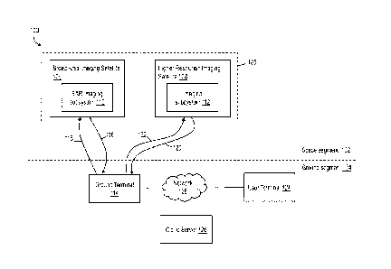
[0127] Referring now to Figure 1, shown therein is a satellite
imaging system 100,
according to an embodiment.
[0128] The system 100 can be used to perform earth observation
tasks using a
plurality of imaging satellites. Earth observation tasks may include, for
example, any one
or more of vessel detection, land intelligence and change detection, asset and
infrastructure monitoring, surface deformation monitoring, oil pollution
monitoring,
humanitarian assistance and disaster relief (HADR) including flood and
earthquake
monitoring, agriculture monitoring, and forestry monitoring. Vessel detection
may include
detecting non-transmitting dark ships, illegal fishing activity, and the like.
[0129] The system 100 may be used to perform cross cueing
operations, such as
described in greater detail herein. The cross cueing may be SAR-to-SAR cross
cueing
or SAR-to-optical cross cueing.
[0130] The system 100 includes a space segment 102 and a ground
segment 104.
The ground segment 104 may have a service-oriented cloud architecture. The
ground
segment 104 includes all elements of the ground including hardware and
software (e.g.
constellation planning subsystem, ordering, tasking, receiving, image
production,
archiving, distribution, etc.).
[0131] The space segment 102 includes a constellation 105 of
imaging satellites
including a broad area imaging satellite 106 and a higher resolution imaging
satellite 108.
The broad area satellite 106 may be a broad area surveillance satellite. The
higher
resolution imaging satellite 108 may be a high resolution target monitoring
satellite. While
the satellite constellation 105 of system 100 is shown having two satellite
106, 108, in
other embodiments, the satellite constellation 105 may have additional imaging
satellites
and the number is not particularly limited. In a particular embodiment, the
satellite
constellation 105 includes at least two higher resolution imaging satellites
108.
[0132] In the system 100, the broad area imaging satellite 106
may be considered
a "leading satellite" and the higher resolution imaging satellite 108 may be
considered a
"trailing satellite". The terms "leading" and "trailing" when used herein in
reference to
satellites is not intended to indicate any particular physical relationship
between the
leading and trailing satellites but rather refers to the fact that the
trailing satellite is used
17
CA 03192971 2023- 3- 16
WO 2022/056638
PCT/CA2021/051298
to perform an imaging operation (i.e. acquisition of image data) after and
based on an
imaging operation performed by the leading satellite. In some cases, the
trailing satellite
may be considered to physically trail the leading satellite by a period of
time (e.g. 1 hour).
The period of time may be termed a "pass interval" of the system 100. The pass
interval
defines a time period between the leading satellite 106 passing over a
location (i.e. the
location is within the satellite's imaging range or view) and the trailing
satellite 108 passing
over the same location (i.e. such that the same location, or approximately the
same
location, can be imaged by both satellites 106, 108). In such cases, the
leading satellite
106 generally acquires image data at a location first and the trailing
satellite 108 acquires
image data at approximately the same location (depending on whether a subject
being
image is static or in motion) second. As a result, the system 100 is generally
configured
to perform certain processing and communication steps, such as those performed
by the
ground segment 104 described herein, within the pass interval such that the
efficiency of
the system 100 is maximized.
[0133] The broad area imaging satellite 106 and higher resolution
imaging satellite
108 are each in an orbit. The respective orbits are predefined orbits.
[0134] In an embodiment, the broad area imaging satellite 106 is
in an inclined
orbit. An inclined orbit is defined by its orbital inclination, which is the
angle between the
plane in which the satellite 106 orbits and a reference plane (i.e. Earth's
equator). Further,
the inclined orbit may be defined as a non-polar orbit. In an embodiment, the
broad area
imaging satellite 106 may have an orbital inclination of about 53.5 degrees.
In an
embodiment, the broad area imaging satellite 106 may have an orbital
inclination
providing access to image between 62.5 degrees N and 62.5 degrees S. For
example,
the broad area imaging satellite 106 may be launched into inclined orbit and
look left and
right (rolling the spacecraft to look left and right of nadir) to provide
image points of the
earth up to 62.5 degrees N and as low as 62.5 degrees S.
[0135] By having an inclined orbit (vs a polar orbit), the broad
area imaging satellite
106 may have increased time spent over revenue generating regions of the globe
and
may allow for imaging at different times of the day and night. Accordingly,
the broad area
imaging satellite 106 may have an orbit that increases or maximizes time over
one or
18
CA 03192971 2023- 3- 16
WO 2022/056638
PCT/CA2021/051298
more revenue generating regions. The revenue generating regions are regions
outside
the polar areas (e.g. Mediterranean, South China Seas, Coasts of N. America,
etc.).
Coverage of the poles is not generally needed to cover the revenue generating
regions.
The inclined orbit of the broad area imaging satellite 106 may maximize the
time spent in
the revenue generating region. The revenue generating regions may be
determined by
looking at an existing imaging satellite's (e.g. RADARSAT-2) revenue
distribution of
customers across the globe. For a polar orbit that is sun synchronous, a
satellite flies
over a point at the same time of day. This is called the "Local Time of the
Ascending
Node", or [TAN, and is measured as the time the satellite crosses the equator
on an
ascending pass (meaning going from south to north). On the other hand, for an
inclined
orbit, there is no fixed [TAN (non-fixed [TAN) as the orbit is constantly
precessing. The
equator crossing time varies throughout an orbital period. As a result, rather
than being
limited to monitoring activity at, for example, 6am and 6pm at every imaging
opportunity,
activity can be monitored across varying times of day. Further, in some cases,
covert
operations may be performed outside of known satellite LTANs. The constantly
changing
LTANs provided by the inclined orbit of the broad area imaging satellite 106
can make it
generally much harder to elude authorities by working around LTANs.
[0136] The inclined orbit of the broad imaging satellite 106 may
improve the
number of imaging opportunities over a particular area in a given day
(revisit).
[0137] In another embodiment, the broad area imaging satellite
106 is in a mid-
inclination orbit. In another embodiment, the broad area imaging satellite 106
is in a sun-
synchronous orbit (SSO).
[0138] In an embodiment, the broad area satellite 106 (and
possibly the higher
resolution satellite 108) has an orbit altitude at which each orbit takes
approximately 97
minutes (orbit completion time). In the inclined orbit described herein, the
97 minutes is
spent flying over a smaller latitude band (+/- 62.5 degrees latitude) instead
of pole-to-pole
(+/- 90 degrees latitude). The area around the poles are low revenue regions
because
other satellites provide "free data" over those regions (e.g. RCM or Sentinel-
1). The broad
imaging satellite 106 in the inclined orbit, however, spends more time in
revenue
generating regions. Further, the revisit opportunities of the satellite 106
(i.e. the time
19
CA 03192971 2023- 3- 16
WO 2022/056638
PCT/CA2021/051298
elapsed between observations of the sample point on earth by the satellite)
may be
thereby improved (higher frequency).
[0139] Generally, satellite mission providers launch into SSO
because it provides
truly global +/- 90 degree latitude coverage (whereas a satellite in the
inclined orbit
described herein may only image below 62.5 deg N and above 62.5 deg S). The
particular
inclined orbit may be selected to maximize the time spent over revenue
generating areas.
[0140] In an embodiment, the higher resolution imaging satellite
108 has the same
orbit inclination as the broad area imaging satellite 106. The higher
resolution imaging
satellite 108 may have the same orbit altitude and inclination as the broad
area imaging
satellite 106. In such an embodiment, the higher resolution imaging satellite
108 may trail
immediately behind the broad area imaging satellite 106 (for example, the
latency
between broad area satellite and higher resolution satellite cross-cue may be
approximately 1 hr).
[0141] In an embodiment, the higher resolution imaging satellite
108 may be in a
sun-synchronous orbit (SSO). SSO is a type of polar orbit. Satellites in SSO
are
synchronous with the sun, such that they pass over an Earth region at the same
local
time every day. For example, the higher resolution imaging satellite 108 may
be part of
a commercial satellite constellation which is in SSO. In embodiments where the
higher
resolution satellite 108 is in SSO, latency in cross cueing between the broad
area satellite
106 and the higher resolution imaging satellite 108 may increase and the
difficulty in
performing tipping and cueing conops described herein as a service may
increase (e.g.
unless there are hundreds of higher resolution satellites in the constellation
to which to
cross cue).
[0142] Each of the imaging satellites 106, 108 (and more
particularly the imaging
subsystems thereof) is adapted to acquire imaging data (e.g. SAR data) of a
predetermined frequency band (e.g. C-band, X-band, etc.). For example, the
broad area
imaging satellite 106 may be configured to acquire and transmit C-band SAR
data and
the higher resolution imaging satellite 108 may be configured to acquire and
transmit X-
band SAR data. The imaging satellites 106, 108 may be further configured to
encrypt
and stored the acquired image data.
CA 03192971 2023- 3- 16
WO 2022/056638
PCT/CA2021/051298
[0143]
Each of the imaging satellites 106, 108 is further adapted to transmit
the
acquired image data to the ground segment 104 and receive instructions and
commands
from the ground segment 104 via an R F signal of a predetermined signal
frequency band.
[0144]
The imaging satellites 106, 108 each have an imaging swath (image scene
size that is collected). The imaging swath of the broad area imaging satellite
106 is
greater than the imaging swath of the high-resolution imaging satellite 108.
The term
"broad area" when used herein in reference to an imaging satellite or
otherwise refers to
a relative relationship between the imaging swath of the imaging satellite to
which it refers
and the imaging swath of another imaging satellite in the system. For example,
the broad
area imaging satellite 106 of system 100 is "broad area" in relation to the
higher resolution
imaging satellite 108 as its respective imaging swath covers a greater area
than that of
the higher resolution imaging satellite 108. Further, the imaging satellites
106, 108 each
have an accessible swath (region where the satellite can look to capture an
image).
[0145]
In an embodiment of the system 100, the number of higher resolution
imaging satellites 108 (or "trailing satellites") used may be based on the
imaging swath
and accessible swath of the broad area imaging satellite 106 and the
respective imaging
swaths and accessible swaths of the higher resolution satellites. For example,
the system
100 may be configured such that the broad area imaging satellite 106 and the
higher
resolution imaging satellites 108 have generally overlapping accessible
swaths. This may
be achieved, for example, by using a plurality (e.g. two) of trailing higher
resolution
imaging satellites 108.
If the broad area satellite 106 accessible swath is
covered/duplicated by the higher resolution imaging satellites 108, the
imaging swath of
the higher resolution satellites 108 may not need to overlap the broad area
satellite 106
imaging swath. In such cases, ground processing, such as performed by the
ground
terminal 114 described below or other component of the ground segment 104, can
determine the coordinates of where to take a second image using the higher
resolution
satellite 108, which is centered on the target of interest (first image via
satellite 106
searches broadly, second image via satellite 108 zooms in).
[0146]
The broad area imaging satellite 106 includes a synthetic aperture
radar
("SAR") imaging subsystem 110. The SAR imaging subsystem 110 includes a SAR
21
CA 03192971 2023- 3- 16
WO 2022/056638
PCT/CA2021/051298
imaging sensor and is configured to perform SAR imaging operations. The SAR
imaging
subsystem 110 acquires and stores SAR data.
[0147] The SAR imaging subsystem 110 may be configured to have
left and right
look directions. As the satellite 106 flies in the velocity direction, it can
roll left (to look off
to the left of the ground track) or right (to look off to the right of the
ground track). Each
"look" represents an accessible swath (e.g. 700km wide, 1400km left and right
combined).
This is different from the imaging swath, which corresponds to the actual
imaged area.
Accessible swath and "look directions" describe the area that "could" be
imaged by the
satellite. The imaging swath is an area within the accessible swath. The
satellite 106 may
have a large accessible swath compared to existing broad area imaging
satellites (e.g.
compared to existing C-band radar satellites). A large accessible swath means
that more
of the earth can be accessed for imaging opportunities with fewer spacecraft.
It may be
useful to look both left and right as total daily access between latitude
bands improves
(e.g. +/- 62.5 degree latitude bands), otherwise there may be gaps in access
where you
may need to wait for the next available pass to image. To facilitate left and
right look
directions, the satellite 106 may include an articulating solar array. The
articulating solar
array may be a gimballed solar array. The gimballed solar array may point at
the sun
while the spacecraft slews from left looking to right looking and vice versa.
[0148] The SAR imaging subsystem 110 may implement a class-
leading access
swath that looks left and right (e.g. 700km wide looking both directions,
combined
1400km). By implementing a wide access swath that can look both left and
right, the
imaging satellite 106 may provide more frequent revisit and better access over
locations
of interest.
[0149] The SAR imaging subsystem 110 of the broad area imaging
satellite 106
includes a SAR antenna. In an embodiment, the SAR antenna has a length of
about 13.5
m x 1.4 m.
[0150] The SAR imaging subsystem 110 may have an accessible swath
width of
approximately 700km. Accessible swath refers to the area where the satellite
can look
within to collect to collect an image. The SAR imaging subsystem 110 may have
a widest
22
CA 03192971 2023- 3- 16
WO 2022/056638
PCT/CA2021/051298
imaging swath of approximately 700km. Imaging swath refers to the area that
the satellite
actually images (i.e. scene size).
[0151] The broad area imaging satellite 106 may have a plurality
of imaging
modes. The imaging modes may include a dual aperture multi-polarization
imaging
mode.
[0152] The broad area imaging satellite 106 may have a maximum
imaging time
per orbit of 30 minutes.
[0153] The broad area imaging satellite 106 may include a direct
downlink. Direct
downlink refers to downlinking any data (SAR, optical, other) directly to a
ground station
that is not necessarily the ground headquarters. For example, the satellite
106 may be
configured to downlink data directly to regional ground station customers
around the world
whenever the satellite 106 passes over the regional ground station
communications cone.
In such cases, the satellite 106 and the ground terminal 114 may be configured
with
hardware and software to facilitate the direct downlink capabilities. The
alternative to
direct downlink is to downlink to an HQ station and then send the data via
some other
means to the end customer, which may add delay to potentially time critical
applications.
[0154] The broad area imaging satellite 106 may include a high-
speed data
downlink subsystem. In an embodiment, the high-speed data downlink subsystem
may
include an X-band downlink. The high-speed data downlink subsystem may be part
of the
satellite's 106 communications subsystem which transmits payload data (e.g.
SAR image
data) from the spacecraft to the ground segment 104 using a predetermined
signal
frequency band (e.g. X-band communications frequencies). The high-speed data
downlink subsystem may have a downlink rate of 300 Mbps x2 (or much higher).
The
high-speed data downlink subsystem may provide downlink speeds which allow
more
images to be downlinked to a ground station (e.g. ground station 114) within a
contact
pass between the satellite and the ground station communications cone.
[0155] The broad area imaging satellite 106 may be configured to
perform direct
tasking. Direct tasking may allow regional ground station customers to send a
command
to task the satellite 106 (an image collection order) directly from their
ground station
communications cone when the satellite 106 is flying overhead. This is in
contrast to
23
CA 03192971 2023- 3- 16
WO 2022/056638
PCT/CA2021/051298
sending an order to a ground headquarters and then tasking the satellite,
which can add
delay. The broad area imaging satellite 106 may be configured to perform fast
tasking
nearly every orbit. The fast tasking is a type of tasking that is high
priority and low latency.
[0156] The broad area imaging satellite 106 includes a solar
array comprising a
plurality of solar panels for generating and providing power to various
electrical
components of the satellite 106. The solar array may be a gimballed array. The
gimballed
array may advantageously generate and provide more power to the satellite 106.
In a
particular embodiment, the broad area imaging satellite 106 may include a
gimballed solar
array and have an inclined orbit. The gimballed solar array may be configured
to
advantageously handle the eclipse conditions experienced in an inclined orbit.
[0157] The higher resolution imaging satellite 108 includes an
imaging subsystem
112. The imaging subsystem 112 may include a SAR imaging sensor and be
configured
to perform SAR imaging operations. In other embodiments, the imaging subsystem
112
may include an optical imaging sensor instead of or in addition to the SAR
imaging sensor.
In such cases, the imaging subsystem 112 is configured to perform optical
imaging
operations.
[0158] The higher resolution imaging satellite 108 is configured
to acquire and
transmit higher resolution image data. The term higher resolution image data
(and the
term "higher resolution", more generally) as used herein is used to refer to a
relative
resolution of the image data captured by the imaging satellite 108 as compared
to the
resolution of the image data captured by the broad area imaging satellite 106.
That is, the
imaging subsystem 112 of the higher resolution imaging satellite 108 is
configured to
acquire higher resolution images than the imaging subsystem 110 of the broad
area
imaging satellite 106.
[0159] In an embodiment, the higher resolution imaging satellite
108 is an X-band
satellite. In a particular embodiment, the higher resolution imaging satellite
108 is an X-
band satellite and the broad area imaging satellite 106 is a C-band satellite.
[0160] The higher resolution imaging satellite 108 may be used
for target
monitoring (and thus be considered a target monitoring satellite). For
example, the higher
resolution imaging satellite 108 may acquire and provide high resolution SAR
imagery for
24
CA 03192971 2023- 3- 16
WO 2022/056638
PCT/CA2021/051298
target monitoring applications (such as described herein) that augment the
broad area
capability of the broad area imaging satellite 106.
[0161] Generally, a broad area (lower resolution) SAR image is
acquired by the
broad area satellite 106 which may be used to tell a user "where" to look.
This first
imaging operation takes advantage of the broad area surveillance capability
(e.g. 700km
accessible swath) of the broad area imaging satellite 106 to look for targets
of interest.
The broad area SAR image can be used to determine coordinates fora subsequent
higher
resolution imaging operation. Once the coordinates of the target are
determined, the
higher resolution satellite 108 is cross cued to take a closer (i.e. higher
resolution) look at
the same target of interest. Without the first broad area SAR image, the
utility of the higher
resolution satellite may be more limited as the accessible swaths are
generally much
lower (e.g. 30km X-band vs. 700km C-band). While this may be less of an issue
for fixed
land-based targets (where to look may already be known), for maritime
surveillance
applications the first, broad area SAR image can be particularly beneficial,
particularly
outside port areas when targets are moving.
[0162] The imaging satellites 106, 108 each include a bus module
in addition to
the respective imaging subsystems 110, 112. The bus module provides attitude
and orbit
control, power generation and storage, payload commands, telemetry, thermal
control
and the primary support structure.
[0163] In some cases, one or both imaging satellites 106, 108 may
include
additional payloads. For example, the broad area imaging satellite 106 may
include an
Automatic Identification System (AIS) for ships, which may be used
independently or in
conjunction with the SAR subsystem 110. In another embodiment, instead of or
in addition
to having an AIS receiver on board the broad area satellite 106, the system
100 may
utilize a third party AIS data provider feeding AIS data directly into the
ground segment
104 (e.g. ground terminal 114). For example, the ground terminal 114 may be
communicatively connected to an AIS data feeding computer system via network
128 and
receive the AIS data from the AIS data feeding system via the network.
Embodiments of
the system 100 including the AIS data feeding system may provide advantages.
For
example, third party AIS data providers may have a global constellation of
satellites
CA 03192971 2023- 3- 16
WO 2022/056638
PCT/CA2021/051298
dedicated to AIS and may be able to provide the ground terminal 114 with ship
track
historical data that can be used to correlate against SAR data generated by
the system
100. In cases where there is no AIS data feeding system and only AIS onboard
the
satellite 106, ship tracking information may only be obtained when the
satellite 106 is
flying overhead.
[0164] Referring now to the ground segment 104 of system 100, the
ground
segment 104 is used generally to command and monitor the satellites 106, 108
for
navigation and imaging, receive satellite telemetry, receive data from the
satellites'
payloads (e.g. imaging subsystems 110, 112); and manage the data for users.
[0165] The ground segment 104 includes a ground terminal 114. The
term ground
terminal may be used to refer to a single ground terminal or multiple ground
terminals.
The ground terminal 114 includes components (e.g. antennas, transmitters,
receivers) for
transmitting signals to and receiving signals from the imaging satellites 106,
108 and
components for processing data (e.g. one or more computing devices, software
modules).
Processing data includes processing image data received from the satellites
106, 108.
[0166] The ground terminal 114 includes a data receiving station
and a data
transmitting station. The data receiving and data transmitting stations may
each be
configured to receive and transmit, respectively, signals of a predetermined
signal
frequency band (e.g. X-band, S-band). Data receiving stations and data
transmitting
stations may be specially adapted to communicate with either the broad area
imaging
satellite 106 or the higher resolution imaging satellite 108 (e.g. a broad
area imaging
satellite receiving station, a higher resolution imaging satellite receiving
station).
[0167] The ground terminal 114 is adapted to receive data from
the broad area
imaging satellite 106 via downlink 116 and transmit data to the broad area
imaging
satellite 106 via uplink 118. The data received via downlink 116 includes SAR
data
acquired by the SAR imaging subsystem 110. The data transmitted via uplink 118
may
include imaging task data instructing the satellite 106 to acquire and return
SAR data from
a particular location (e.g. coordinates).
[0168] The ground terminal 114 is adapted to receive data from
the higher
resolution imaging satellite 108 via downlink 120 and transmit data to the
higher resolution
26
CA 03192971 2023- 3- 16
WO 2022/056638
PCT/CA2021/051298
imaging satellite 108 via uplink 122. The data received via downlink 120
includes image
data acquired by the imaging subsystem 112. The data transmitted via uplink
122 may
include imaging task data instructing the satellite 108 to acquire and return
higher
resolution image data from a particular location (e.g. coordinates).
[0169] The ground segment 104 also includes a user terminal 124
and a cloud
server 126. The terms user terminal and cloud server may be used to refer to a
single
user terminal or cloud server or multiple user terminals or cloud servers. The
user
terminal 124 and cloud server 126 are communicatively connected to the ground
terminal
114, and to each other, via network 128. The network 128 may include local
area network
connections and/or wide area network connections (e.g. the Internet).
[0170] The user terminal 124 is a computing device configured to
perform data
processing functions and transmit data to and receive data from other
computing devices
such as ground terminal 114 and cloud server 126 via network connections such
as
network 128.
[0171] The user terminal 124 may include a client-side software
application
configured to communicate with a server-side application running on the cloud
server 126
or the ground terminal 114. The client-side software application may include a
user
interface for receiving input data from a user (e.g. requesting an imaging
task, other Ul
interactions) and outputting data to the user (e.g. displaying processed image
data or an
output or determination of an image data processing operation performed. The
user
interface may be a web-based user interface. The user of the user terminal 124
may be
an analyst trained to analyze SAR or other image data.
[0172] The cloud server 126 may include a cloud-based software
application
configured to communicate with a client-side software application running on
the user
terminal 124 or a software application running on the ground terminal 114. For
example,
the ground terminal 114 may upload image data to the cloud server 126, which
may then
store the image data linked to a user account, which can be accessed by the
user terminal
124.
[0173] The ground segment 104 may include a modular instance of
data chain to
support network station upgrades.
27
CA 03192971 2023- 3- 16
WO 2022/056638
PCT/CA2021/051298
[0174] The system 100 may be used to perform maritime cross
cueing to detect
target vessels. For example, the broad area satellite 106 may collect a broad
area SAR
image in which a plurality of vessels (e.g. ships) are seen. The ships and
ship locations
may be correlated by the ground terminal 114 against AIS data from an AIS data
feeding
system (e.g. AIS data provider who operates its own constellation of AIS
satellites). Most
ships are likely transmitting an AIS signal broadcasting their respective ID,
position, and
heading. From this, a determination may be made using the ground terminal 114
identifying the ships in the broad area SAR image that are transmitting AIS.
The ships
that are not correlated at the ground terminal 114 may be taken to represent
leftover dark
targets and thus may be considered potential vessels of interest for
interdiction of further
monitoring. Further monitoring may include tasking the higher resolution
satellite 108 to
acquire higher resolution SAR image data of the dark targets using coordinates
determined from the broad area SAR image.
[0175] Referring now to Figure 2, shown therein is a method 200
of operation of
the satellite imaging system 100 of Figure 1, according to an embodiment.
[0176] At 202, the broad area imaging satellite 106 receives
first imaging task data
from the ground terminal 114 via uplink 118. The first imaging task data
describes a first
imaging task to be performed by the broad area imaging satellite 106 includes
first
imaging coordinates and a command/instructions to acquire SAR data at the
first imaging
coordinates.
[0177] The first imaging task may be generated by ground terminal
114. In some
cases, the first imaging task may be generated at the ground terminal 114 in
response to
an imaging task request initiated at the user terminal 124 (e.g. a user at
user terminal 124
inputs a task request using the client-side application). The imaging task
request may be
sent to the cloud server 126 and/or the ground terminal 114 via the network
128. Where
the imaging task request is sent to the cloud server 126, the cloud server may
process
and transmit the imaging task request to the ground terminal 114.
[0178] At 204, the broad area imaging satellite 106 acquires
first SAR data at the
first imaging coordinates using the SAR imaging subsystem 110. The broad area
imaging
satellite 106 may process, encrypt, and store the SAR data using an on-board
processor
28
CA 03192971 2023- 3- 16
WO 2022/056638
PCT/CA2021/051298
and memory. The first SAR data is of a first predetermined frequency band. The
first
SAR data may be C-band SAR data.
[0179] At 206, the broad area imaging satellite 106 transmits the
first SAR data to
the ground terminal 114 via downlink 116. The first SAR data is transmitted as
an RF
signal of a predetermined frequency band.
[0180] At 208, the ground terminal 114 receives the first SAR
data. The ground
terminal 114 processes the first SAR data to determine second imaging
coordinates. The
second imaging coordinates can be used in a subsequent "targeted" imaging
operation.
[0181] Generally, the first SAR data may be at a resolution that
allows a
determination to be made that a particular object, subject, or image context
is present but
that is not sufficient to determine the type or nature of the object, subject,
or image
context. Further, the first SAR data is of a sufficient resolution to
determine the second
imaging coordinates. For example, the first SAR data may be sufficient to
identify that an
object is present at a particular location (due to, for example, contrast with
surroundings
(e.g. water)), but not sufficient to identify the object (e.g. as a particular
type of vessel)
with a required degree of certainty.
[0182] In some cases, step 208 may include determining whether
the subsequent
imaging operation is needed. For example, upon processing and analysis of the
first SAR
data, it may be determined that the subsequent imaging operation is not
required. This
determination may be performed automatically by the ground terminal 114 (e.g.
using
machine learning techniques) or may include a user input provided at the user
terminal
124 (e.g. displaying an output of processing the first SAR data at the user
terminal and
receiving an input at the user terminal indicating whether to perform the
second imaging
operation, the input then provided to the ground terminal).
[0183] In embodiments where the method 200 is used to image or
monitor a
moving image subject, the ground terminal 114 is configured to determine a
motion
artifact for the image subject and use the motion artifact in determining the
second
imaging coordinates. In such cases, the ground terminal 114 may effectively
predict the
location (i.e. coordinates) of the image subject at the time of the second
imaging
operation.
29
CA 03192971 2023- 3- 16
WO 2022/056638
PCT/CA2021/051298
[0184] At 210, the ground terminal 114 transmits second imaging
task data to the
higher resolution imaging satellite 108 via the uplink 122. The second imaging
task data
describes a second imaging task to be performed by the higher resolution
imaging
satellite 108 includes the second imaging coordinates and a
command/instructions to
acquire SAR data at the second imaging coordinates.
[0185] In embodiments where the satellite constellation 105
includes multiple
higher resolution satellites 108, the ground terminal 114 may also determine
to which of
the higher resolution satellites the second imaging task should be sent.
[0186] At 212, the higher resolution satellite 108 receives the
second imaging task
data from the ground terminal 114 via the uplink 122.
[0187] At 214, the higher resolution satellite 108 acquires
second SAR data (or
optical data, if the higher resolution satellite 108 is configured to collect
optical data) at
the second imaging coordinates. The higher resolution imaging satellite 108
may process,
encrypt, and store the second SAR data using an on-board processor and memory.
The
second SAR data is of a first predetermined frequency band. The second SAR
data may
be X-band SAR data.
[0188] As described, the second SAR data is of a higher
resolution than the first
SAR data.
[0189] At 216, the higher resolution imaging satellite 108
transmits the second SAR
data to the ground terminal 114 via downlink 120.
[0190] At 218, the ground terminal 114 receives and processes the
second SAR
data.
[0191] At 220, an image context is determined using the processed
second SAR
image data. Determining an image context may include, for example, determining
an
identity of an object present in the second SAR data (e.g. a vessel).
[0192] Determining the image context may include a user input
(e.g. an operator
trained in analyzing SAR image data). For example, the second SAR data may be
provided to the user terminal 124 via the network 128 and displayed in a user
interface.
The displayed SAR data may then be analyzed by the operator of the user
terminal 124.
CA 03192971 2023- 3- 16
WO 2022/056638
PCT/CA2021/051298
The user may provide input data to the user terminal 124 via the user
interface, which
may then be provided to one or more other devices connected to the user
interface (e.g.
ground terminal 114, cloud server 126, or another computer system).
[0193] In other cases, determining the image context from the
second SAR data
may be performed automatically, such as through the application of machine
learning
techniques.
[0194] For example, the ground terminal 114 may include a machine
learning
module configured to determine an image context from the second SAR data. The
machine learning module includes a machine learning model that has been
trained using
a set of SAR training images. The machine learning model may be a neural
network or
the like. The machine learning model may be a classification model configured
to receive
the second SAR data as an input and generate a class assignment or label as an
output.
The machine learning model may also provide a confidence level with the class
label
indicated a level of confidence that the class label is accurate. The
classification model
may be configured to perform a binary classification task in which the input
second SAR
data is assigned to one of two mutually exclusive classes (e.g. "problem
vessel" or not a
problem vessel"). The classification model may be configured to perform a
multi-class
classification task in which the input second SAR data is assigned one of more
than two
classes.
[0195] In cases where the ground terminal 114 performs machine
learning to
determine an image context, the image context may be considered the output of
the
machine learning model (e.g. the class label).
[0196] The output of the machine learning module may be provided
to the user
terminal 114 and displayed in a user interface for review by an operator. In
some cases,
the output may only be provided to the user terminal upon determination of a
particular
image context (e.g. assignment of a certain class label). In other cases, the
output of the
machine learning module may not be provided to the user terminal 124 for
review and
instead may be transmitted to another computer system for subsequent action or
may be
further processed.
31
CA 03192971 2023- 3- 16
WO 2022/056638
PCT/CA2021/051298
[0197] Referring now to Figure 3, shown therein is a block
diagram 300 of the broad
area imaging satellite 106 of Figure 1, according to an embodiment. Variations
of the
broad imaging satellite 106 may include additional or fewer components.
[0198] The satellite 106 includes an orbital control unit 302 and
a satellite
positioning unit 304. The orbital control unit 302 in configured to maintain
the satellite
106 in its predefined orbit. In some cases, orbital control data may be
provided to the
orbital control unit 302 from the ground terminal 114. The satellite
positioning unit 304
positions or repositions (e.g. via actuators, propulsion subsystem) the
satellite 106 based
on an output provided by the orbital control unit 302.
[0199] In an embodiment, the orbital control unit 302 stores data
indicating an
inclined orbit for the satellite 106. The inclined orbit may have an orbit
inclination of about
53.5 degrees. The inclined orbit may have latitude extents of approximately +/-
62.5
degrees. The orbital control unit 302 maintains the satellite 106 in the
inclined orbit.
[0200] The satellite 106 includes a data storage 306 for storing
various forms of
data generated by or provided to the satellite 106. The data storage 306 may
be any
suitable data storage element. The data storage 306 may include memory or
other forms
of data storage.
[0201] The satellite includes a receive antenna 308 for receiving
an RF signal of a
predetermined signal frequency band from the ground terminal 114. The received
RF
signal includes first imaging task data (such as the first imaging task data
described in
Figure 2).
[0202] The receive antenna 308 provides the received RF signal to
a receive unit
310. The receive unit 310 generates a decoded signal 312 from the received RF
signal.
The decoded signal 312 is stored in the data storage 306. The decoded signal
312
includes the first imaging task data 314.
[0203] The decoded signal 306 is provided to a tasking unit 316
configured to
extract and determine the first imaging task data 314 from the decoded signal
306. The
first imaging task data 314 is stored in data storage 306.
32
CA 03192971 2023- 3- 16
WO 2022/056638
PCT/CA2021/051298
[0204] The tasking unit 316 processes the first imaging task data
314 to determine
first imaging coordinates 318 defining a location at which to acquire SAR
data. The first
imaging coordinates 318 are stored in the data storage 306.
[0205] The first imaging coordinates 318 are provided to an image
acquisition unit
320 configured to generate an image acquisition command 322. Generating the
image
acquisition command 322 may include determining a sensor positioning command
324
(e.g. if the satellite 106 is to look left or right to acquire the SAR data).
The sensor
positioning command 324 may be provided to a sensor positioning unit 326. The
sensor
positioning unit 326 is configured to direct a SAR imaging sensor 328 (e.g.
SAR beam) in
response to the sensor positioning command 324.
[0206] The SAR imaging sensor 328 is in communication with the
image
acquisition unit 320 and the sensor positioning unit 326. The SAR imaging
sensor 328
receives the imaging acquisition command 322 instructing the SAR imaging
sensor 328
to acquire SAR data at the first imaging coordinates 318. In response to
receiving the
imaging acquisition command 322, the SAR imaging sensor 328 acquires broad
area
SAR image data 330 at the first imaging coordinates 318. The broad area SAR
image
data 330 is stored in the data storage 306.
[0207] The satellite 106 includes a task response generator unit
332. The task
response generator unit 332 is configured to use first imaging task data 314
and the broad
area SAR image data 330 to generate task response data 334. The task response
data
334 represents a response to the first imaging task that includes the broad
area SAR
image data 330. The task response data 334 is stored in the data storage 306.
[0208] The task response data 334 is provided to a transmit unit
336. The transmit
unit 336 generates an encoded transmit signal 338. The encoded transmit signal
338
includes the task response data 334, which includes the broad area SAR image
data 330.
[0209] The transmit unit 336 provides the encoded transmit signal
338 to a transmit
antenna 340 for transmitting an RF signal of a predetermined signal frequency
band to
the ground terminal 114. The transmit antenna 340 transmits the RE signal
based on the
received encoded transmit signal 338.
33
CA 03192971 2023- 3- 16
WO 2022/056638
PCT/CA2021/051298
[0210] Referring now to Figure 4, shown therein is a block
diagram 400 of the
higher resolution imaging satellite 108 of Figure 1, according to an
embodiment.
Variations of the higher resolution imaging satellite 108 may include
additional or fewer
components.
[0211] The satellite 108 includes an orbital control unit 402 and
a satellite
positioning unit 402. The orbital control unit 402 in configured to maintain
the satellite
108 in its predefined orbit. In some cases, orbital control data may be
provided to the
orbital control unit 402 from the ground terminal 114. The satellite
positioning unit 404
positions or repositions (e.g. via actuators, propulsion subsystem) the
satellite 108 based
on an output provided by the orbital control unit 402.
[0212] In an embodiment, the orbital control unit 402 stores data
indicating a polar
orbit for the satellite 108. In a particular embodiment, the polar orbit is a
sun-synchronous
orbit. The orbital control unit 402 maintains the satellite 108 in the sun-
synchronous orbit.
[0213] The satellite 108 includes a data storage 406 for storing
various forms of
data generated by or provided to the satellite 108. The data storage 406 may
be any
suitable data storage element. The data storage 406 may include memory or
other forms
of data storage.
[0214] The satellite includes a receive antenna 408 for receiving
an RF signal of a
predetermined signal frequency band from the ground terminal 114. The received
RF
signal includes second imaging task data (such as the second imaging task data
described in Figure 2). The second imaging task data may describe a targeted
imaging
or targeted monitoring task in which a previously imaged subject (i.e. in the
first imaging
task) is being imaged a second time at a higher resolution.
[0215] The receive antenna 408 provides the received RF signal to
a receive unit
410. The receive unit 410 generates a decoded signal 412 from the received RF
signal.
The decoded signal 412 is stored in the data storage 406. The decoded signal
412
includes the second imaging task data 414.
34
CA 03192971 2023- 3- 16
WO 2022/056638
PCT/CA2021/051298
[0216] The decoded signal 406 is provided to a tasking unit 416
configured to
extract and determine the second imaging task data 414 from the decoded signal
406.
The second imaging task data 414 is stored in data storage 406.
[0217] The tasking unit 316 processes the second imaging task
data 414 to
determine second imaging coordinates 318 defining a location at which to
acquire SAR
data (or optical imaging data if the sensor is an optical sensor). The second
imaging
coordinates 418 are stored in the data storage 406.
[0218] The second imaging coordinates 418 are provided to an
image acquisition
unit 420 configured to generate an image acquisition command 422. Generating
the
image acquisition command 422 may include determining a sensor positioning
command
424. The sensor positioning command 424 may be used to direct an image sensor
of the
satellite 108 to a particular location. The sensor positioning command 424 may
be
provided to a sensor positioning unit 426. The sensor positioning unit 426 is
configured
to direct a SAR imaging sensor 428 (e.g. SAR beam) in response to the sensor
positioning
command 424. In other embodiments, the satellite 108 may include an optical
imaging
sensor instead of or in addition to the SAR imaging sensor 428.
[0219] The SAR imaging sensor 428 is in communication with the
image
acquisition unit 420 and the sensor positioning unit 426. The SAR imaging
sensor 428
receives the imaging acquisition command 428 instructing the SAR imaging
sensor 428
to acquire SAR data at the second imaging coordinates 418. In response to
receiving the
imaging acquisition command 422, the SAR imaging sensor 428 acquires higher
resolution SAR image data 430 at the second imaging coordinates 418. The
higher
resolution SAR image data 430 is stored in the data storage 406.
[0220] The satellite 108 includes a task response generator unit
432. The task
response generator unit 432 is configured to use second imaging task data 414
and the
higher resolution SAR image data 430 to generate task response data 434. The
task
response data 434 represents a response to the second imaging task that
includes the
higher resolution SAR image data 430. The task response data 434 is stored in
the data
storage 406.
CA 03192971 2023- 3- 16
WO 2022/056638
PCT/CA2021/051298
[0221] The task response data 434 is provided to a transmit unit
436. The transmit
unit 436 generates an encoded transmit signal 438. The encoded transmit signal
438
includes the task response data 434, which includes the higher resolution SAR
image
data 430.
[0222] The transmit unit 436 provides the encoded transmit signal
438 to a transmit
antenna 440 for transmitting an RF signal of a predetermined signal frequency
band to
the ground terminal 114. The transmit antenna 440 transmits the RF signal
based on the
received encoded transmit signal 438.
[0223] Referring now to Figure 5, shown therein is a block
diagram 500 of the
ground terminal 114 of Figure 1, according to an embodiment. The ground
terminal 114
may include one or more physical components or devices. The components
illustrated
and described in reference to Figure 5 may be implemented at one or more
physical
devices. Certain units or modules may be implemented using software, hardware,
or
some combination of hardware and software. In cases where the ground terminal
114
includes multiple devices, such devices may be configured to communication
with one
another via wired or wireless communication connection (e.g. to provide an
output of one
unit or module as input to another unit or module). For example, computing
devices may
be communicatively connected via a network connection (wired or wireless).
[0224] The ground terminal 114 includes a processor 502 in
communication with a
memory 504 and a communication interface 506. The processor 502 is configured
to
execute computer-executable instructions embodied in one or more modules or
units
described in Figure 5. The memory 504 stores various data provided to or
generated by
the ground terminal 114 and the computer-executable instructions executed by
the
processor 502. The communication interface 506 permits communication with
other
systems or computing devices; for example, over a local area network or wide
area
network (e.g. over the Internet). For example, the communication interface 506
may be
used to communicate with the cloud server 126 or user terminal 124 of Figure
1.
[0225] The ground terminal 114 includes an imaging task generator
unit 508
configured to generate first imaging task data 510. The first imaging task
data 510 defines
a first imaging task to be performed by the broad area imaging satellite 106
and includes
36
CA 03192971 2023- 3- 16
WO 2022/056638
PCT/CA2021/051298
first imaging coordinates and instructions to acquire SAR data at the first
imaging
coordinates. The first imaging task data 510 is stored in memory 504.
[0226] The ground terminal 114 includes a transmit unit 512
configured to encode
the first imaging task data 510 in a transmittable signal 514.
[0227] The transmit unit 512 provides the transmittable signal
514 to a transmit
antenna 516. The transmit antenna 516 receives the transmittable signal 514
and is
configured to generate and transmit a RF signal in a format receivable by a
receive
antenna of the broad area imaging satellite 106 (e.g. receive antenna 308 of
Figure 3).
The RF signal is of a predetermined signal frequency band.
[0228] The ground terminal 114 includes a receive antenna 518 for
receiving an
RF signal of a predetermined signal frequency band from the broad area imaging
satellite
106. The received RF signal represents a response to the first imaging task.
[0229] The receive antenna 518 is connected to a receive unit
520. The receive
antenna 518 provides the received RF signal to the receive unit 520. The
receive unit
520 decodes the received RF signal to obtain first task response data 522. The
first task
response data 522 is stored in memory 504. The first task response data 522
indicates
it is a response to the first imaging task described in the first imaging task
data 510.
[0230] The ground terminal 114 includes a task response processor
unit 524. The
task response processor unit 524 is configured to receive and process the
first task
response data 522 to obtain broad area SAR data 526. The broad area SAR data
526 is
stored in memory 504.
[0231] The ground terminal 114 includes a location predictor unit
528. The location
predictor unit 528 is configured to analyze the broad area SAR data 526 (and
possibly
other first task response data 522) to determine location data 530. The
location data 530
is stored in memory 504. The location data 530 indicates a location at which
to acquire
additional (higher resolution) SAR data (i.e. where to point the higher
resolution satellite
108). The location data 530 may include coordinates (e.g. second imaging
coordinates
418 of Figure 4). The location predictor unit 528 may be configured to
determine whether
a subject in the broad area SAR data 526 is stationary or in motion. When the
image
37
CA 03192971 2023- 3- 16
WO 2022/056638
PCT/CA2021/051298
subject is in motion, the location predictor unit 528 is configured to predict
an anticipated
future location of the image subject (e.g. using a motion artifact determined
for the image
subject). For example, where the image subject is a marine vessel, it may be
expected
if the marine vessel is in motion that the marine vessel will have moved
locations between
imaging by the broad area satellite 106 and the higher resolution satellite
108.
[0232] The location data 530 is provided as input to the imaging
task generator unit
508, which generates second imaging task data 532 which includes the location
data 530
and instructions to acquire SAR data at the location defined in the location
data 530. The
second imaging task data 532 is stored in memory 504.
[0233] The second imaging task data 532 is provided as input to
the transmit unit
512 which encodes the second imaging task data 532 into a transmittable signal
536.
[0234] The transmit unit 512 provides the transmittable signal
536 to the transmit
antenna 516. The transmit antenna 516 receives the transmittable signal 536
and is
configured to generate and transmit a RF signal in a format receivable by a
receive
antenna of the higher resolution imaging satellite 108 (e.g. receive antenna
408 of Figure
4). The RF signal is of a predetermined signal frequency band.
[0235] The ground terminal 114 receives an RF signal from the
higher resolution
imaging satellite 108 encoding a response to the second imaging task 532 via
the receive
antenna 518.
[0236] The receive antenna 518 provides the received RF signal to
the receive unit
520, which decodes the received RF signal to obtain second task response data
538.
The second task response data 536 is stored in memory 504. The second task
response
data 536 indicates it is a response to the second imaging task described in
the second
imaging task data 532.
[0237] The second task response data 536 is provided to the task
response
processor unit 524, which processes the second task response data to obtain
higher
resolution SAR data 540. The higher resolution SAR data 540 is stored in
memory 504.
[0238] The ground terminal 114 further includes an image data
analysis unit 542.
The image data analysis unit 542 is configured to analyze the higher
resolution SAR data
38
CA 03192971 2023- 3- 16
WO 2022/056638
PCT/CA2021/051298
540 to determine image context data 544. The image context data 544 describes
a
context for the higher resolution SAR data 540, such as an identity of an
image subject
(e.g. an object in the image)
[0239]
The image data analysis unit 542 includes a machine learning module
546.
The machine learning module 546 includes a machine learning model trained
using a set
of SAR training images having the same resolution as the higher resolution SAR
data
540. The machine learning module 546 receives the higher resolution SAR data
540 and
provides the SAR data 540 as input to the machine learning model. The machine
learning
model is configured to receive the higher resolution SAR data 540 as input and
generate
an output comprising the image context data 544. In an example, the machine
learning
model may be a classification model and the image context data 544 may be a
class label
assigned to an object in the higher resolution SAR data 540.
[0240]
In other embodiments, the image data analysis unit 542 may be
configured
to render the higher resolution SAR data 540 in a user interface, which can be
displayed
at the user terminal 124. The image data analysis 542 may further configured
to receive
input data (e.g. image context data 544) provided by the user via the user
interface.
[0241]
Referring now to Figure 6, shown therein is a system 600 for performing
maritime cross-cueing using a satellite constellation, according to an
embodiment. The
system 600 is an example implementation of the system 100 of Figure 1.
[0242]
The system 600 can perform cross-cueing operations. The cross-cueing
includes the passing of detection, geolocation, and targeting information to
another
sensor with or without human intervention. Generally, the system 600 uses a
lower
resolution, broad area capability satellite and a higher resolution, narrower
area capability
satellite to perform cross-cueing. The broad area capability satellite is used
to acquire
broad area surveillance SAR data and the higher resolution, narrower area
capability
satellite is used to acquire high resolution, target monitoring SAR data.
[0243]
In the example of Figure 6, the cross-cueing operation includes dark
ship
detection.
Generally, dark ship detection includes identifying vessels without an
automatic identification system ("AIS") and hotspots where potential illegal
activity is
occurring. The system 600 may use spaceborne SAR sensors to detect non-
transmitting
39
CA 03192971 2023- 3- 16
WO 2022/056638
PCT/CA2021/051298
vessels. Vessels without AIS may be considered non-transmitting dark ships.
The
automatic identification system (AIS) is an automatic tracking system that
uses
transceivers on ships and is used by vessel traffic services. Satellites can
be used to
detect AIS signatures, in which case the term Satellite-AIS (S-AIS) may be
used. S-AIS
may be used for collision avoidance, identification, and location information,
as well as
for maritime domain awareness, search and rescue, environmental monitoring,
and
maritime intelligence applications.
[0244] The system 600 includes a space segment 602 and a ground
segment 604.
[0245] The space segment 602 includes a C-band SAR imaging
satellite 606 ("C-
band satellite") and an X-band SAR imaging satellite 608 ("X-band satellite).
The C-band
satellite 606 may be the broad area satellite 106 of Figure 1. The X-band
satellite may
be the higher resolution satellite 108 of Figure 1. C-band SAR imaging
satellite 606 may
correspond to first satellite 1102 of Figures 8-9 or first satellite 1202 of
Figures 10-11.
[0246] The C-band and X-band satellites are configured to acquire
C-band SAR
data and X-band SAR data, respectively, and transmit the SAR data to the
ground
segment 604. The X-band satellite 608 may be considered a trailing satellite
with respect
to the C-band satellite 606. The trail time of the X-band satellite 608 with
respect to the
C-band satellite 606 may be approximately 1 hour. The C-band satellite 606 is
in an
inclined orbit. The inclined orbit may have an orbital inclination of about
53.5 degrees.
The inclined orbit may have latitude extents of +/- 62.5 degrees. The X-band
satellite 608
may have a sun-synchronous orbit or may have the same orbit as the C-band
satellite
606 (e.g. inclined orbit).
[0247] The C-band satellite 606 has an access swath 610 that is
broader than an
access swath 612 of the X-band satellite 608.
[0248] The C-band and X-band satellites 606, 608 can be used to
image one or
more vessels (not shown) which may or may not be transmitting an AIS signature
(via an
AIS transmitting unit).
CA 03192971 2023- 3- 16
WO 2022/056638
PCT/CA2021/051298
[0249] In the example of Figure 6, a vessel has been identified
as a non-
transmitting vessel. A user of the system 600 may wish to determine whether
the non-
transmitting vessel is a threat, such as a pirated oil tanker.
[0250] The C-band satellite 606 may receive first imaging task
data from the
ground segment 604 instructing the C-band satellite 606 to acquire SAR data at
first
imaging coordinates based on the identification of a non-transmitting vessel.
In other
cases, the first image by the C-band satellite 606 may represent a broad area
sweep and
it may not be known what vessels are transmitting and not transmitting. The
SAR image
data may be downlinked to the ground segment and compared against AIS to
determine
vessels of interest. The X-band satellite 608 may then be tasked by the ground
segment
to acquire higher resolution image data at a certain location thought to
include the non-
transmitting vessel.
[0251] The C-band satellite 606 acquires lower resolution SAR
data at the first
imaging coordinates and transmits the acquired SAR data to a data exploitation
system
via downlink 614. The data exploitation system includes a signal receiving
station 616
for receiving the signal from the C-band satellite and a data exploitation
processing device
618 for processing the lower resolution SAR data to generate low resolution
image 620.
The processing device further processes the lower resolution SAR data to
determine
second imaging coordinates for a targeted imaging operation to be performed by
the X-
band satellite 608. The second imaging coordinates represent a predicted
location of the
non-transmitting vessel when the X-band satellite 608 passes over the non-
transmitting
vessel.
[0252] The processing device 618 is connected to a mission
control processing
device 622 of a mission control system via network 624.
[0253] The processing device 622 receives the second imaging
coordinates and
generates second imaging task data describing a second, targeted imaging task
which is
transmitted to a mission control transmitting station 626. The mission control
transmitting
station 626 transmits the second imaging task data as an RF signal to the X-
band satellite
608 via uplink 628.
41
CA 03192971 2023- 3- 16
WO 2022/056638
PCT/CA2021/051298
[0254] The X-band satellite 608 receives the RF signal and
decodes the second
imaging task data including the second imaging coordinates. The X-band
satellite 608
acquires higher resolution SAR data at the second imaging coordinates. The X-
band
satellite 608 transmits the higher resolution SAR data to the receiving
station 614 of the
data exploitation system via downlink 630.
[0255] The RF signal carrying the higher resolution SAR data is
received at the
receiving station and transmitted to the processing device 616, which
generates high
resolution image 632. High resolution image 632 may be a SAR image having a
resolution high enough that a trained operator can analyze the image 632
visually and
determine its contents (e.g. determine the type or nature of the non-
transmitting vessel).
Accordingly, the high resolution image 632 may be provided to a user terminal
(e.g. user
terminal 124 of Figure 1) which may render the high resolution in a user
interface for
review by the trained operator. In other cases, the high resolution image 632
may be
provided to a machine learning model configured to analyze the SAR data and
determine
(e.g. assign a class label) whether an object in the high resolution image 632
belongs to
a certain class (i.e. whether it is a threat or not).
[0256] The data exploitation system may include a plurality of
receiving stations
and a plurality of processing devices. In some cases, receiving stations 614
of the data
exploitation system may be specially adapted to receive SAR data from either C-
band
satellite 606 or the X-band satellite 608. Similarly, the mission control
system may include
a plurality of processing devices 622 and a plurality of transmitting stations
626.
[0257] As described above, the system 600 may advantageously
provide for the
identification and targeted monitoring, via acquisition and analysis of SAR
imaging data,
of non-transmitting vessels in order to determine whether such non-
transmitting vessels
present a credible threat.
[0258] Referring now to Figure 7, shown therein is a ground
segment architecture
700 for satellite imaging, according to an embodiment. The ground segment
architecture
700 may be implemented, for example, in the ground segment 104 of Figure 1.
[0259] The ground segment architecture 700 includes network
stations 702 and
SIX ground terminals 704. The S-band ground terminal is used to send commands
to the
42
CA 03192971 2023- 3- 16
WO 2022/056638
PCT/CA2021/051298
spacecraft in S-band. The X-band ground terminal is used to receive SAR
payload data
from the spacecraft in X-band. The ground terminal (S, X) include an antenna
and
associated communications infrastructure. The S/X ground terminals 704 include
an
external S/X ground terminal 706 and an internal S/X ground terminal 708.
[0260] The network station 702 connects to a C-band SAR imaging
satellite 710
via an uplink and sends mission control data from the network station 702 to
the satellite
710 via the uplink. The SAR imaging satellite 710 is configured to acquire SAR
image
data.
[0261] The network stations 702 are communicatively connected to
a mission
control module 712 of an HQ ground segment 714. The SAR HQ ground segment 714,
and components thereof such as the mission control module 712, may be
implemented
using one or more computing devices. In cases where the SAR HQ ground segment
714
includes a plurality of computing devices, the computing devices are
communicatively
connected via a network (such as the Internet) using wireless or wired
connections.
[0262] The network stations 702 transfer data to and receive data
from the mission
control module 712. In doing so, the network stations 702 facilitate
communication
between the mission control module 712 and the satellite 710. The mission
control
module 712 includes a planning submodule 716, a spacecraft control submodule
718, a
calibration submodule 720, and a pass management submodule 722.
[0263] The S/X ground terminals 704 connect to the satellite 710
via a downlink
and receive SAR image data from the satellite 710 via the downlink.
[0264] The S/X ground terminals 704 are communicatively connected
to a data
chain module 724 of the SAR HQ ground segment 714. The S/X ground terminals
704
transfer SAR image data (received from the satellite 710) to the data chain
module 724.
The data chain module 724 includes an ordering submodule 726, a contact
management
submodule 728, a reconstruction submodule 730, a SAR data processing submodule
732, a vessel detection submodule 734, an AIS ingestion/association submodule
736,
and a product delivery submodule 738.
43
CA 03192971 2023- 3- 16
WO 2022/056638
PCT/CA2021/051298
[0265] The SIX ground terminals 704 are also communicatively
connected to the
mission control module 712 for transferring data to and receiving data from
the mission
control module 712.
[0266] The SAR HQ ground segment 714 also includes operator
dashboards 740.
The operator dashboards 740 may provide one or more user interfaces enabling a
user-
operator to interact with the mission control module 712 and the data chain
module 724
(e.g. by inputting data to or viewing a data output thereof).
[0267] The SAR HQ ground segment 714 also includes support
services 742. The
support services 742 are communicatively connected to the mission control
module 712
and the data chain module 724 such that the support services 742 can transfer
data to
and receive data from the mission control module 712 and data chain module
724.
[0268] The support services 742 are communicatively connected to
a financial
system 744. The support services 742 may transfer data to and receive data
from the
financial system 744. The support services 742 may facilitate between the
financial
system 744 and other components of the SARHQ ground segment 714 (e.g. the data
chain module 724).
[0269] The mission control module 712 and the data chain module
724 are
communicatively connected for the exchange of data therebetween. In an
example, the
data chain module 724 may generate coordinates for an imaging task based on
SAR
image data acquired by the satellite 710 and provide the coordinates to the
mission
control module 712. The mission control module 712 may then use the
coordinates to
generate an imaging task including the coordinates which can be transmitted to
a satellite
for a subsequent imaging operation at a location based on the coordinates.
[0270] The data chain module 724 is also communicatively
connected to a value-
added processing module 746. The value-added processing module 746 receives
data
from the data chain module 724. The value-added processing module 746
processes the
received data and provides the processed data to customers 748. Customers 748
may
also transmit data to and receive data directly from the data chain module
724. Customers
748 may interact with the value-added processing module 746 and the data chain
module
44
CA 03192971 2023- 3- 16
WO 2022/056638
PCT/CA2021/051298
724 via a user interface configured to receive input data from the customer-
user and
present data outputted by the modules 724, 746.
[0271] Additional embodiments related to satellite-based
observation and
surveillance in which image data captured by a satellite is processed onboard
the satellite
will now be described in further detail with reference to Figures 8-17. The
systems,
methods, and concepts related to the embodiments of Figures 8-17 may be used,
in whole
or in part, within the systems, methods, and concepts described above in
reference to
Figures 1-7. Likewise, the systems, methods, and concepts related to the
embodiment of
Figures 1-7 may be used, in whole or in part, within the systems, methods, and
concepts
described in reference to Figures 8-17. For example, satellite onboard data
processing
functionalities described in Figures 8-17 may be implemented on satellite 106
or satellite
108 of Figure 1.
[0272] The embodiments described below may have various
applications. The
systems and methods may be used to detect objects in satellite image data. The
objects
may be moving or non-moving. Moving objects may include vehicles (e.g. land-
based,
marine, spacecraft) or other moving targets. The systems and methods may be
used in
applications such as marine vessel detection (e.g. dark vessel detection),
space traffic
management, and land-based tracking operations (e.g. vehicle convoys, port
activity
monitoring, railroad monitoring). As such, the systems and methods may acquire
and
process image data of any one or more of a marine environment, land-based
environment, or a space environment. The systems and methods described below
may
enable direct downlink of lower bandwidth products in theatre.
[0273] Onboard data processing of satellite imaging data, such as
SAR data, may
advantageously allow for prioritization of data for limited downlink
scenarios.
Embodiments implementing the onboard data processing on a reprogrammable
processor such as an FPGA may enable on-orbit updates to image processing
algorithms
(e.g. SAR processing algorithms) or modules, which can be particularly
advantageous.
Generally, the onboarding data processing of satellite imaging data described
herein
produces a smaller data size, which can result in a smaller link to ground,
more
CA 03192971 2023- 3- 16
WO 2022/056638
PCT/CA2021/051298
opportunities to downlink products, and less latency from time of image to
time of product
being in the possession of end users who need the product.
[0274] Referring first to Figure 8, pictured therein is a block
diagram of a system
100 for earth observation, according to an embodiment.
[0275] System 1100 includes a first satellite 1102 and a first
ground terminal 1104.
The first satellite 1102 may be any satellite type known in the art that may
support an
earth observation payload. In the embodiment of system 1100, satellite 1102
refers to a
physical satellite. In other embodiments, satellite 1102 may be a sub-
component of a
satellite, another spacecraft, or an aircraft. In the embodiment of system
1100, first
satellite 1102 is in low earth orbit (LEO).
[0276] First satellite 1102 includes a communications subsystem
1118, an earth
observation system 1120, and a processor 1122. The communications subsystem
1118
comprises an uplink (UL) subsystem 1118a, and a downlink (DL) subsystem 1118b.
First
satellite 1102 may correspond to satellite 606 of Figure 6.
[0277] The uplink subsystem 1118a is configured to receive an
order 1300 from
the first ground terminal 1104. The uplink subsystem 1118a in the embodiment
of Figure
8 comprises an S-Band RF communication receiver. In other embodiments, the
uplink
subsystem 1118a may comprise any other component known in the art for
receiving
communications at a satellite from a ground terminal, including other RF
bands.
[0278] The downlink subsystem 1118b is configured to transmit a
processed
product to another external terminal. The downlink subsystem 1118b in the
embodiment
of Figure 8 comprises an S-Band RF communication transmitter. In other
embodiments,
the downlink subsystem 1118b may comprise any other component known in the art
for
transmitting date from a satellite to a ground terminal or another satellite,
including other
RF bands.
[0279] The earth observation system 1120 comprises a synthetic
aperture radar
(SAR) unit. The synthetic aperture radar (SAR) unit may be operated to acquire
SAR data
of the surface of the earth (or other celestial body, as the case may be in
other
embodiments), as directed by the order. In other examples of system 1100, the
earth
46
CA 03192971 2023- 3- 16
WO 2022/056638
PCT/CA2021/051298
observation system may comprise any earth observation system known in the art
for
imaging and or surveilling the surface of the earth. Examples of other earth
observation
systems may include visible light observation systems, infrared observation
systems and
other radar-based observation systems. In some examples, earth observation
system
1120 may capture C-band radar data.
[0280] The processor 1122 may be any processor suitable for use
on an on-orbit
satellite and which can perform processing tasks as described herein. The
processor
1122 may comprise a field programmable gate array based earth observation data
processor. The processor 1122 is configured to communicate with, and pass data
to and
from the earth observation system 1120 and communication subsystem 1118. In
some
examples, processor 1122 may comprise multiple sub processors, one of which
may be
used to conduct on-board processing of earth observation data. In some
examples,
processor 1122 may include a processor and memory. In some examples, processor
1122 may comprise a field programmable gate array (FPGA) based processor. In
some
examples, processor 1122 may comprise a Xilinx XORKU060 FPGA. In some
examples,
processor 1122 may include NOR flash for the storage of FPGA configuration
programming.
[0281] First ground terminal 1104 includes a communications
subsystem 1126,
and an order receiving unit 1124. The communications subsystem 1126 includes
an
uplink subsystem 1126a.
[0282] Order receiving unit 1124 is configured to receive an
order from an external
terminal or inputted to the first ground terminal by an operator through a
human input
device, such as a keyboard, mouse or touchscreen.
[0283] The uplink subsystem 1126a is configured to transmit the
order 1300 to the
first satellite 1102. The uplink subsystem 1126a in the embodiment of Figure 8
comprises
an S-Band RE communication transmitter. In other embodiments, the uplink
subsystem
1126a may comprise any other component known in the art for transmitting
communications to a satellite from a ground terminal, including other RF
bands.
[0284] During the operation of system 1100, the first ground
terminal 1104 receives
an order 1300 at its order receiving unit 1124. The order 1300 may be provided
to the
47
CA 03192971 2023- 3- 16
WO 2022/056638
PCT/CA2021/051298
order receiving unit 1124 by an external terminal, or input into first ground
terminal 1104
by a human input device, such as a keyboard, mouse, or touchscreen. In some
cases,
the order 1300 may be input through a graphical user interface executing on
the first
ground terminal 1104 or on an external terminal from which the first ground
terminal 1104
may be receiving the order 1300. In this way, an order 1300 may be submitted
to the first
ground terminal 1104 either through the first ground terminal 1104 or an
external terminal
communicatively connected to the first ground terminal 1104 (e.g. via a
network, such as
a LAN or WAN).
[0285] Referring now to Figure 12, pictured therein is a block
diagram depicting the
structure of an order 1300, according to an embodiment.
[0286] The order 1300 may include a header 1302, capture location
data 1304,
object of interest data 1306, desired processed product data 1308, and product
destination data 1310.
[0287] Header 1302 may include administrative data, identifying
data, such as the
operator who generated the order 1300, timestamp data, and other
administrative data
which may provide logistical functionality.
[0288] Capture location data 1304 may include data defining a
location and or area
of the earth's surface for earth observation, such as coordinate data. For
example,
capture location data 1304 may include the coordinate of a center point of an
earth
observation area. In other examples, capture location data 1304 may include a
parametric
description of an earth observation area, for example, a center point, and
radius,
describing a circular area.
[0289] Object of interest data 1306 specifies an object of
interest that is to be
subject of the capture data processing and analysis. The object of interest
may include a
certain type or class of object which an individual associated with system
1100 may be
interested in. The object of interest may include a class of objects which a
user of the
system 1100 wishes to detect the presence of in image data. For example, the
object of
interest data 1306 may specify ships, motor vehicles, military equipment,
weapon
installations, oil spills, buildings, or other fixed structures. Generally, an
object of interest
may be considered anything that the processor 1122 of the first satellite is
configured to
48
CA 03192971 2023- 3- 16
WO 2022/056638
PCT/CA2021/051298
detect or identify in capture data. The object of interest data 1306 can thus
be used by
the processor 1122 to perform an appropriate object detection or capture data
analysis
task. For example, different capture data analysis techniques and processing
pipelines
may be used for different objects of interest.
[0290] Desired processed product data 1308 specifies a desired
processed
product to be generated by the processor 1122 of the first satellite 1102. The
desired
processed product may include a number of possible processed products,
including a list
of detected objects of interest, an object of interest location, an object of
interest
characterization, an object of interest classification, an object of interest
velocity, and
object of interest image chips. Desired processed product 1308 may specify all
possible
products, or a subset of possible products that can be generated by the
processor 1122.
[0291] Product destination data 1310 specifies a destination
terminal or device for
the processed product specified in the desired processed product data 1308.
The product
destination data 1310 may include a final destination for processed products.
For
example, when system 1100 is employed in a maritime surveillance context, the
product
destination data 1310 may include a specific maritime vessel used to respond
to unknown
detected vessels within the observation area.
[0292] In some examples, order 1300 may include only a subset of
the
subcomponents detailed in Figure 12.
[0293] In some examples, order 1300 may be received or input into
the first ground
terminal 1104 in the final desired format, as described above in reference to
Figure 12. In
other examples, order 1300 may be processed by the first ground terminal 1104
to convert
order 1300 into a format readable by first satellite 1102.
[0294] In some examples, a ground terminal 1104 may communicate
with a
plurality of prospective first satellites. Each first satellite may be
configured to observe a
certain portion of the earth's surface. The ground terminal 1104 may determine
which first
satellite to transmit the order 1300 to depending on the capture location data
1304 in the
order. For example, the ground terminal 1104 may further comprise a database
of
possible first satellites, and associated observation ranges of all first
satellites. The
49
CA 03192971 2023- 3- 16
WO 2022/056638
PCT/CA2021/051298
ground terminal 1104 may determine which first satellites are within range.
The ground
terminal 1104 may then deliver the order 1300 to a first satellite within
imaging range.
[0295] In other examples, the header 1302 may include first
satellite data, such
that the ground terminal 1104 may determine desired first satellite by parsing
header 1302
data, wherein a destination first satellite is encoded.
[0296] Referring again to Figure 8, first ground terminal 1104
may transmit the
order 1300 to first satellite 1102. First satellite 1102 may receive the order
1300
transmitted from the first ground terminal 1104 using the uplink subsystem
1118a. The
order 1300 may be passed to the processor 1122, which may parse the order 1300
and
pass the order 1300 or some subset thereof to the earth observation system
1120.
[0297] The earth observation system 1120 may be operated to
acquire earth
observation data, of an area of the earth's surface 1114 as directed by
capture location
data 1304. In other embodiments, such as those relating to space traffic
management,
the earth observation system 1120 may be directed to capture an area of space
(rather
than of the earth's surface),
[0298] In some examples, first satellite 1102 may further
comprise a propulsion
system and an attitude control system. The propulsion system may be operated
to change
the orbit parameters to position first satellite 1102 such that the first
satellite 1102 is in a
position such that earth observation system 1120 may acquire earth observation
data as
directed by capture location data 1304. The attitude control system may be
operated to
orient or change where the spacecraft is pointing. Once satellite 1102 is in
the correct
position and orientation, earth observation system 1120 may acquire earth
observation
data.
[0299] Earth observation data may be passed to processor 1122 for
the generation
of a processed product 1400.
[0300] Referring now to Figure 13, pictured therein is a block
diagram depicting
components of a processed product 1400, according to an embodiment. The
processed
product 1400 may comprise a header 1402, an object of interest report 1412,
and object
of interest image chips 1410. The object of interest report 1412 may include
any one or
CA 03192971 2023- 3- 16
WO 2022/056638
PCT/CA2021/051298
more of object of interest location data 1404, object characterization data
1406, and
object of interest velocity data 1408 (e.g. in the case of moving object or
target detection).
Systems and methods described herein may be used to detect, locate and
characterize
objects captured by an earth observation system. In the context of object
detection
onboard processing, characterization may mean description of physical
characteristics of
a detected object, for example object length, width, surface area, etc.
[0301] Header 1402 may comprise administrative data, identifying
data, such as
the operator who generated the order 1300, timestamp data, first satellite
data, and other
administrative data which may provide logistical functionality.
[0302] Object of interest report 1412 may include object of
interest location data
1404, object characterization data 1406, and object of interest velocity data
1408. In some
cases, the object of interest report 1412 may include the object of interest
image chips
1410 (e.g. with object of interest image chips 1410 associated with data in
the object of
interest report 1412 describing the object of interest captured in the image
chip). Object
of interest report 1412 may also include administrative data, such as
timestamp data, first
satellite data, and other administrative data which may provide logistical
functionality.
[0303] Object of interest location data 1404 may comprise an
output of the location
of all detected objects of interest. Object of interest location data 1404
may, for example,
specify coordinates defining a location for one or more detected objects. The
object of
interest location data 1404 may include a listing of the coordinates of the
geometric center
point of all located objects of interest.
[0304] Object characterization data 1406 may include a
qualitative or quantitative
characterization of each object of interest. The object characterization data
may describe
one or more physical characteristics of the object (e.g. vessel), such as, for
example
object length, object width, object surface area, etc. For example, if the
object of interest
1306 specified by the order is marine vessels, object characterization 1406
may comprise
an output characterizing each located object of interest into distinct,
predetermined
classes. For example, if the system described herein is used for marine
surveillance, the
objects of interest may be marine vessels. Object characterization 1406 output
in such
an example may comprise qualitative characterizations of each located object
of interest,
51
CA 03192971 2023- 3- 16
WO 2022/056638
PCT/CA2021/051298
such as "aircraft carrier", "submarine" or "cruiser". In some cases, the
object
characterization data 1406 may include an object classification (e.g. a class
assignment
or label), specifying a class of object to which the object of interest
belongs, determined
via an object detection or object classification task performed by the
processor 1122.
[0305] Object of interest velocity data 1408 may include an
output of a velocity of
each detected object of interest. The output may be a numerical speed and
direction of
motion of each detected object of interest.
[0306] Object of interest image chips 1410 may comprise image
crops of each
detected object of interest. Image chips 1410 may provide value to end users
of the
system, as each located object of interest may be quickly manually verified
through visual
inspection. An operator may examine an image chip of a detected object of
interest to
confirm that the processor 1122 correctly identified the object of interest.
Additionally, an
operator may examine an image chip of a detected object of interest to extract
information
that may not be captured when characterizing objects. For example, an object
may be
classified as a large ship via the object of interest characterization data
1406. An operator
may visually inspect the corresponding image chip to identify whether the ship
is a military
or civilian vessel.
[0307] In some cases, object of interest image chips 1410 may be
used as input to
an object of interest classification module implementing one or more
classification
algorithms for classifying the object of interest in the image chip 1410. The
object of
interest classification algorithm may be any suitable classification
algorithm. For example,
the object of interest classification module may implement a machine learning-
based
classification model or algorithm. The object of interest classification
module may be
implemented on a processing unit of a ground-based terminal (e.g. ground
terminal 1210,
ground terminal 1212), in which case the image chip 1410 may be received by
downlink
from the first satellite 1202 and processed via the classification module to
determine a
class assignment for the object of interest. Classification data may then be
displayed or
further communicated to other terminals (e.g. as part of processed product
1400). In other
embodiments, the object of interest classification module may be implemented
on the
processor of the first satellite (e.g. processor 1122, 1222). The
classification module may
52
CA 03192971 2023- 3- 16
WO 2022/056638
PCT/CA2021/051298
process the image chip 1410 via the classification module to determine a class
assignment for the object of interest. The classification data may then be
communicated
to another terminal, such as a ground terminal or second satellite (e.g.
second satellite
1106), for example as part of processed product 1400 (e.g. within object of
interest
report).
[0308] Referring again to Figure 8, processor 1122 may process
earth observation
data, as directed by order 1300. Processor 1122 may parse object of interest
1306 and
desired processed product 1308 of order 1300 to determine what information is
to be
identified and processed, and what outputs are to be generated. Processor 1122
may
output a processed product 1400. Processed product 1400 may be transmitted to
another
terminal for further use.
[0309] Referring now to Figure 9, pictured therein is an
embodiment of system
1100 as described above in reference to Figure 8, further comprising a second
satellite
1106 and a response agent 1108. The system 1100 of Figure 9 includes
intersatellite
communication of processed product 1400 that is generated onboard the first
satellite
1102 via the processor 1122.
[0310] Second satellite 1106 includes a communication subsystem
1130, including
an uplink subsystem 1130a and downlink subsystem 1130b. Second satellite 1106
may
be configured as a relay satellite, wherein the second satellite 1106 is
configured to
receive a signal from one satellite and transmit the same signal (i.e relay)
to another
satellite or to a ground station or terminal. The second satellite 1106 may
have any
suitable orbit for providing the signal relay function. In some examples,
second satellite
1106 may be in a geosynchronous orbit (GEO). In some examples, second
satellite 1106
may be in a low earth orbit (LEO). In a particular embodiment, the second
satellite 1106
may be part of a relay network of satellites, such as a GEO satellite relay
network.
[0311] Response agent 1108 may comprise any vehicle, system, or
individual
which may respond to an object located by the systems described herein. For
example,
in marine surveillance applications, response agent 1108 may comprise a marine
patrol
vessel. Further, response agent 1108 includes, is connected to, or has access
to a
receiving terminal including a communication subsystem and a computing device.
The
53
CA 03192971 2023- 3- 16
WO 2022/056638
PCT/CA2021/051298
communication subsystem is configured to receive communications from the
second
satellite (transmitted via DL subsystem 1130b). The computing device may be
configured
to process the processed product in its received format into a format suitable
for output.
The computing device is configured to output the processed product 1400 in a
human
readable format. For example, the computing device may be configured to
execute a
graphical user interface module for displaying the processed product or
elements thereof
in human readable format.
[0312] In the system 1100 of Figure 9, first satellite 1102
transmits processed
product 1400 to second satellite 1106 using its downlink subsystem 1118b.
Second
satellite 1106 receives the processed product 1400 via uplink subsystem 1130a.
In
system 1100 of Figure 9, downlink subsystem 1118b may comprise an
intersatellite link
configured to communicate with another orbiting satellite, and uplink
subsystem 1130a
may be configured to receive communications from another orbiting satellite.
The
intersatellite link may be implemented separately from an uplink/downlink
subsystem
used to communicate with a ground station.
[0313] Second satellite 1106 may transmit the processed product
1400 to
response agent 1108 using downlink subsystem 1130b. Second satellite 1106 may
use
the product destination data 1310 of order 1300 to determine where (i.e. to
which
response agent 1108) to transmit the processed product 1400.
[0314] Response agent 1108 may receive processed product 1400 via
its receiving
terminal. Response agent 1108 may proceed to respond to detected objects of
interest
that are of particular concern. This may include objects which present safety
or security
risks.
[0315] Referring now to Figure 10, pictured therein is a system
1200 for earth
observation with onboard processing, according to an embodiment. Description
above in
reference to system 1100 applies to system 1200. System 1200 comprises all
components of system 1100 and further comprises second ground terminal 1210
and
third ground terminal 1212. In some cases, second and third ground terminals
1210, 1212
may be the same ground terminal.
54
CA 03192971 2023- 3- 16
WO 2022/056638
PCT/CA2021/051298
[0316] In the operation of system 1200, first satellite 1202 may
transmit processed
product 1400 to second ground terminal 1210 via the downlink subsystem 1218b.
Second
ground terminal may receive processed product 1400 via a downlink subsystem
and
transmit processed product 1400 to third ground terminal 1212 via a
communication
interface (e.g. network interface, where the second and third ground terminals
are
communicatively connected via a network connection, such as a LAN or WAN).
Third
ground terminal may receive processed product 1400 via a communication
interface and
transmit processed product 1400 to second satellite 1206. Second satellite
1206 may
transmit processed product 1400 to response agent 1208. Response agent 1208
may
utilize information contained within processed product 1400 to conduct an
operation.
[0317] The first satellite 1102 to second satellite 1106
communication link of
system 1100 may require line of sight between the first satellite 1102 and
second satellite
1106. System 1200 may advantageously allow for communication wherein the first
satellite 1202 and second satellite 1206 are not within line of sight.
Additionally, inter-
satellite communication may require an additional or specialized
intersatellite
communication subsystem. In examples wherein the second satellite 1206 is in
geosynchronous orbit, line of sight between first satellite 1102 and second
satellite 1106
will generally be available. Thus, embodiments including relay from the first
satellite 1102
through one or more ground terminals to the second satellite 1106 and then to
the
response agent (end user) may be particularly advantageous.
[0318] Referring now to Figure 11, pictured therein is a further
embodiment of the
system 1200 of Figure 10. The system 1200 of Figure 11 further comprises cloud
server
1228. Second ground terminal 1210 is configured to communicate with third
ground
terminal 1212 through cloud server 1228. Cloud server 1228 may be any server
type
known in the art that allows for transmitting communications between two
terminals.
[0319] Passing processed product 1400 through cloud server 1226
when
transmitting the processed product 1400 from the second ground terminal 1210
to third
ground terminal 1212 may provide further functionality. For example, the
presence of
cloud server 1228 in the communication chain may enable cloud server 1228 to
further
process processed product 1400 during transmission. For example, the cloud
server 1228
CA 03192971 2023- 3- 16
WO 2022/056638
PCT/CA2021/051298
may store correlation data that can be used by the cloud server 1228 to
further verify
detected objects identified in the processed product 1400. In an example, the
correlation
data may identify or describe objects that are not of interest or of concern
and which may
not warrant a response or treatment as a detected object, and the data
describing
detected objects in the processed product 1400 may be compared to the
correlation data
to identify "matches". The matches may then be communicated as part of the
processed
product 1400 or along with the processed product 1400, for example as an
annotation to
the processed product 1400 (e.g. flagging or labelling detected objects that
have matches
in the correlation data). Similarly, detected objects without "matches" in the
correlation
data may be flagged or labelled. In other cases, the cloud server 1228 may be
configured
to alter the processed product 1400, such as by removing detected objects that
have
matches in the correlation data.
[0320] In examples wherein the systems described herein are used
in maritime
surveillance applications, cloud server 1228 may enable dark target
correlation with
automatic identification system (AIS) functionality. The cloud server 1228 may
be a third
party AIS data provider. Within a given earth observation area, there may
exist a number
of marine vessels. Cloud server 1228 may comprise an AIS database including
all current
known transmitting ships, as detected by AIS. Vessels that are not present
within the
database may be termed "dark ships" or "dark targets". Cloud server 1228 may
reference
the AIS database to determine whether any located marine vessels are not
present within
the AIS database, and label non-present vessels as dark targets. Dark targets
may
comprise high priority detected vessels, as dark targets may present greater
security
risks. Response agent 1208 may respond to dark targets at a higher priority or
may only
respond to dark targets. In other cases, the cloud server 1228 may simply feed
AIS data
(which AIS data may be determined by the contents of the processed product
1400, such
as location data) to the third ground terminal 1212. The cloud server 1228 may
receive
AIS data from a global constellation of satellites dedicated to AIS and may
provide the
system 1200 with ship track historical data that can be used for correlation
with the
processed product 1400.
[0321] In other examples of the systems described herein, dark
target correlation
may be performed without a cloud server, and instead may be performed by any
one of
56
CA 03192971 2023- 3- 16
WO 2022/056638
PCT/CA2021/051298
the first ground terminal 1104, 1204, first satellite 1102, 1202 or second
satellite 1106,
1206. In cases where such dark target correlation is performed by satellite,
the performing
satellite may include an AIS payload for performing ship tracking. In cases
where such
dark target correlation is performed by satellite, the dark target correlation
may be
performed by onboard processor 1122, 1222. Similarly, in other embodiments
directed to
forms of data correlation other than AIS for dark target correlation in which
data correlation
is performed by the satellite, the onboard processor 1122, 1222 may be
configured to
perform the data correlation.
[0322] Referring now to Figure 14, pictured therein is a flow
chart detailing a
method 1500 of earth observation with onboard processing, according to an
embodiment.
Method 1500 includes steps 1502, 1504, 1506, 1508, and optionally 1510, and
1512.
Description above in reference to Figures 8-13 applies to method 1500.
[0323] At 1502, an order, such as order 1300, is received at a
first ground station.
The order specifies an earth observation task.
[0324] At 1504, the order is transmitted from the first ground
terminal to a first
satellite.
[0325] At 1506, the earth observation unit is operated to acquire
earth observation
data. The acquisition of earth observation data is based on the order.
[0326] At 1508, the earth observation data is processed to
generate a processed
product, such as processed product 1400.
[0327] At 1510, the processed product is transmitted to a second
satellite. The
processed product may be transmitted to the second satellite via an
intersatellite link.
[0328] At 1512, the processed product is transmitted to a
response agent.
[0329] Referring now to Figure 15, pictured therein is a flow
chart detailing a
method 1600 of earth observation with onboard processing, according to an
embodiment.
Method 1600 includes steps 1602, 1604, 1606, 1608, 1610, 1612, 1614, and 1616.
[0330] At 1602, an order, such as order 1300, is received at a
first ground station.
The order specifies an earth observation task.
57
CA 03192971 2023- 3- 16
WO 2022/056638
PCT/CA2021/051298
[0331] At 1604, the order is transmitted from the first ground
terminal to a first
satellite.
[0332] At 1606, the earth observation unit is operated to acquire
earth observation
data.
[0333] At 1608, the earth observation date is processed to
generate a processed
product, such as processed product 1400.
[0334] At 1610, the processed product is transmitted to a second
ground terminal.
[0335] At 1612, the processed product is transmitted to a third
ground terminal. In
some examples of method 1600, processed product may be transmitted directly
from the
second ground terminal to the third ground terminal. In other examples,
processed
product may be transmitted from the second ground terminal to the third ground
terminal
through a cloud server, such as cloud server 1228.
[0336] At 1614, processed product is transmitted to a second
satellite.
[0337] At 1616, processed product is transmitted to a response
agent.
[0338] Referring now to Figure 16, pictured therein is a block
diagram of a
processing pipeline 1700 for performing processing of earth observation data
onboard a
satellite ("onboard processing"), according to an embodiment.
[0339] The processing pipeline 1700 may be implemented on a
processor suitable
for use on an on-orbit satellite such that, when in orbit, the processor can
process earth
observation data using the pipeline 1700. For example, processing pipeline
1700 may be
implemented in processor 1122 of first satellite 1102 as described above. In
an
embodiment, the processor may be an FPGA-based processor. In such an
embodiment,
the processing pipeline 1700 may represent an FPGA design for the onboard
processing.
[0340] Description above in reference to Figures 8-15 applies to
pipeline 1700.
While Figure 16 references SAR data, in other embodiments the pipeline 1700
may be
used, with appropriate modification, to process other forms of image data.
[0341] The processing pipeline includes a plurality of software
modules including
an input data parser module 1702, a pre-processing module 1704, a SAR
processor
58
CA 03192971 2023- 3- 16
WO 2022/056638
PCT/CA2021/051298
module 1720, a masking module 1706, an object detection module 1708, a
detected
object velocity estimation module 1722, a detected object report generator
module 1710,
an image chip generator module 1712, a data compression module 1714, an
encryption
module 1716, and an output data buffer module 1718.
[0342] The input data parser module 1702 is configured to receive
raw SAR data
as input and parse the raw SAR data to generate parsed SAR data. The parsed
SAR data
is outputted to the pre-processing module 1704. The input data parser module
1702 may
be configured to parse all input data, strip off headers, and initialize any
necessary
parameters. The output of the input data parser module 1702 may include parsed
raw
data without headers.
[0343] The pre-processing module 1704 is configured to receive
the output of the
input data parser module 1702 as input and perform pre-processing on the
parsed SAR
data to generate pre-processed SAR data. The pre-processed SAR data is
outputted to
the SAR processor module 1720. In an embodiment, the pre-processing module
1704 is
configured to execute any calculations that can be done before processing
starts. The
input to the pre-processing module 1704 may include parsed data, as well as
commands
and parameters. The output generated by the pre-processing module 1704 may
include
(pre-processed) data and pre-calculated parameters needed for SAR processing
(e.g. by
module 1720).
[0344] The SAR processor module 1720 is configured to receive the
pre-processed
SAR data as input and process the received input to generate an output
comprising SAR
imagery. The SAR processor module 1720 may be configured to process SAR
imagery
according to any suitable technique. The SAR processor module 1720 may be
configured
to receive the pre-processed SAR data as input and output processed bursts or
strips of
SAR imagery. The output generated by the SAR processor module 1720 is
outputted to
the masking module 1706 and the detected object velocity estimation module
1722. In
embodiments not including a masking module 1706, the output may be provided to
the
object detection module 1708. In some embodiments, SAR processor module 1720
may
be configured to process multi-aperture SAR data.
59
CA 03192971 2023- 3- 16
WO 2022/056638
PCT/CA2021/051298
[0345] In an embodiment, the SAR processor module 1720 is the
main module for
processing raw data and creating images to be used for object detection or
other modules.
The output of SAR processor module 1720 may include SAR imagery (SAR image
data)
processed in strips or bursts. Whether the output includes SAR imagery
processed in
strips or bursts depends on the SAR mode.
[0346] In an embodiment, the SAR processor module 1720 may
perform multi-
aperture range-Doppler SAR processing with Doppler centroid estimation. The
range-
Doppler aspect of the SAR processing algorithm may include Spectral Analysis
(SpecAn)
and Fast Convolution versions. In another embodiment, the SAR processor module
1720
may implement a Back Projection (BP) SAR processing algorithm.
[0347] As noted, variations of the SAR processor module 1720 may
use Doppler
centroid estimation by implementing a Doppler centroid estimation algorithm.
The Doppler
centroid algorithm may be configured to estimate the center frequency of the
Doppler
spectrum of the data, related to the azimuth beam center. The Doppler centroid
may be
estimated at different ranges in the data and a polynomial function of range
may be fitted
to the measurements. The Doppler centroid may be updated in successive azimuth
blocks.
[0348] The masking module 1706 is configured to receive processed
SAR data as
input and perform a masking operation on the processed SAR data to generate
masked
SAR data. The masking operation is configured to mask areas of the SAR data
that are
not relevant to the object detection operation and may otherwise potentially
lead to false
detections.
[0349] In an embodiment, the masking module 1706 may be
configured to access
a database comprising polygons describing areas or objects which are to be
masked (e.g.
ignore points). Masks stored in the database may be intended to mask or
obscure certain
objects or portions of an image which are known to be not of interest and thus
can be
obscured to reduce potential for false detections.
[0350] For example, for maritime surveillance applications, the
masking module
706 may be a land masking module configured to access a database comprising
polygons
describing world land masses. The land mask is extracted from the database and
applied
CA 03192971 2023- 3- 16
WO 2022/056638
PCT/CA2021/051298
to the input data. All land mass may be excluded from further processing, to
prevent
objects in the masked area from being detected. In other examples, other areas
may be
masked, for example, known secure zones wherein no surveillance is required.
Masking
may reduce the capture area which must be analyzed for object detection,
reducing
processing time and decreasing observation latency.
[0351] The masking module 1706 outputs the masked SAR data to the
object
detection module 1708.
[0352] The object detection module 1708 is configured to perform
object detection
tasks on received SAR data. This may include masked SAR data or unmasked SAR
data.
In an embodiment, the object detection module 1708 may be configured to detect
one or
more classes of objects in the SAR data and output a list of detected objects
or annotated
SAR image including an object class assignment and bounding box coordinates
for each
detected object.
[0353] In an embodiment, the object detection module 1708 may be
configured to
solve an optimization problem. For example, individual pixels may be detected
first and
then clustered together based on proximity to form object detections. The
output of the
object detection module 1708 may include a geographic location and one or more
characteristics for each detected object.
[0354] In another embodiment, the object detection module 1708
may be
configured to implement a Constant False Alarm Rate (CFAR) technique for
object
detection. The CFAR technique may characterize background imagery using a
statistical
fit to the background clutter (e.g. background sea clutter in a vessel
detection embodiment
of object detection) and noise with the fit being applied on a tile-by-tile
basis. Different
types of CFAR techniques may be used, such as K-distribution and tri-modal
distribution.
For this kind of object detection, any statistical distribution function may
be used.
[0355] The object detection output generated by the object
detection module 1708
is outputted to the detected object report generator module 1710 and the image
chip
generator module 1712. In embodiments including the object velocity estimation
module
1722, the object detection output is provided to the object velocity
estimation module
1722.
61
CA 03192971 2023- 3- 16
WO 2022/056638
PCT/CA2021/051298
[0356] The object velocity estimation module 1722 is configured
to receive outputs
from the multi-aperture specAn SAR processor with doppler centroid estimation
module
1720 and the object detection module 1708 and determine an estimated object
velocity
for one or more objects detected by the object detection module 1708. The
estimated
object velocity values are outputted to the detected object report generator
module 1710.
[0357] In an embodiment, velocity estimation is performed based
on co-registration
of two images from two data receiver channels. The input to the velocity
estimation
module 1722 is processed SAR image for each channel and the output is
estimation of
radial velocity for each detected vessel.
[0358] In an embodiment, the velocity estimation module 1722 may
implement a
Space Time Adaptive Processing (STAP) approach for estimation of object
velocity. For
STAP to be applicable, a minimum of two spatial channels of data are needed,
in this
case one is from the Fore and the other from the Aft wing of the antenna.
Example types
of STAP technique which may be used for object velocity estimation include
Displaced
Phase Centre Antenna (DPCA) and ATI (Along Track Interferometry).
[0359] The detected object report generator module 1710 is
configured to receive
the object detection output and, if present, the estimated object velocity
values, and
generate a detected object report. Generally, the detected object report
includes data
describing one or more detected objects. The data may include, for example,
location,
characterization (object type or class), velocity, heading, etc. The detected
object report
may correspond to the object of interest report 1412 of processed product 1400
described
above.
[0360] In an embodiment, reports provide a summary of each
detected vessel.
Reports may include vessel location, characteristics and radial velocity
estimation. In an
embodiment, one report is created for each detected vessel. In an embodiment,
the report
format may comprise simple text.
[0361] The detected object report is outputted to the encryption
module 1716 (or
the output data buffer module 1718 in embodiments not including encryption).
62
CA 03192971 2023- 3- 16
WO 2022/056638
PCT/CA2021/051298
[0362] The image chip generator module 1712 is configured to
receive the object
detection output including the SAR data and data describing the detected
objects (such
as location in the image) and generate an image chip of each detected object.
The image
chip may correspond to a cropped portion of the image including the detected
object.
[0363] In an embodiment, one image chip is generated for each
detected object.
The size of the image chip is based on the size of the object (e.g. vessel)
and represents
an extended bounding box around the object in the processed SAR image.
[0364] The image chips generated by the image chip generator
module 1712 are
outputted to the data compression module 1714.
[0365] The data compression module 1714 is configured to compress
received
data according to any suitable data compression scheme. The data compression
module
1714 compresses the image chips to generate compressed image chips, which are
outputted to the encryption module 1716 (or to the output data buffer module
1718 in
embodiments without encryption). Image chips may be compressed using standard
compression methods.
[0366] As pictured in Figure 16, 1710 and 1712 and 1714 may be
performed in
parallel in some examples of pipeline 1700. Performing these steps in parallel
may
provide a computational speed improvement to pipeline 1700. Such parallel
processing
may advantageously provide reduced latency.
[0367] The encryption module 1716 is configured to encrypt
received data
according to any suitable encryption scheme. The encryption module 1716
receives the
detected object report and the compressed image chips as input and generates
an
encrypted detected object report and encrypted image chips. The encrypted
detected
object report and image chips may be assembled into a processed product, such
as
processed product 1400 of Figure 13. Data is encrypted by encryption module
1716 using
standard ways to encrypt satellite downlink data. Encryption module 1716 may
employ
commercial grade encryption. For example, the data may be encrypted per AES-
CCM.
[0368] The encrypted detected object report and encrypted image
chips are
outputted to the output data buffer module 1718, which outputs the processed
product.
63
CA 03192971 2023- 3- 16
WO 2022/056638
PCT/CA2021/051298
The output data buffer module 1718 is configured to store all object detection
onboard
processing outputs until they are ready to be downlinked or transmitted to
another
satellite.
[0369] In other embodiments of pipeline 1700, some components or
modules may
be omitted. For example, in embodiments wherein earth observation operations
do not
require elevated security, encryption module 1716 may not be required.
[0370] Referring now to Figure 17, shown therein is a block
diagram depicting an
object detection onboard processing architecture and data flow 1800, according
to an
embodiment. The object detection onboard processing architecture and data flow
1800
may be implemented in an earth orbiting satellite, for example, first
satellite 1102 of
system 1100.
[0371] Architecture and data flow 1800 includes a capture tasking
input 1802, an
S-band uplink subsystem 1804, a spacecraft computer 1806, a capture task 1826,
an
earth observation capture unit 1828, raw capture data 1830, an object
detection onboard
processing unit 1808, a processed product 1824, an S-band downlink subsystem
1832,
and an output to user 1834.
[0372] The object detection onboard processing unit 1808 includes
a plurality of
software modules which, when executed by the onboard processing unit 1808,
cause the
onboard processing unit 1808 to perform functions and provide functionalities
as
described herein. The object detection onboard processing module 1808 includes
a raw
capture data processing module 1810, an object detection module 1812, a
detected
object velocity estimation module 1814, a detected object report generator
module 1816,
an image chip generator module 1818, a data compression module 1820, a data
encryption module 1822 and optionally a AIS data correlation module 1836. The
object
detection onboard processing unit 1808 may correspond to the processor 1122 as
described above in reference to system 1100.
[0373] The capture tasking input 1802 comprises information
communicated to the
satellite via an external terminal, such as a ground terminal (e.g. first
ground terminal
1104 of Figure 8) describing an image capture task to be performed by the
satellite. The
64
CA 03192971 2023- 3- 16
WO 2022/056638
PCT/CA2021/051298
capture tasking input 1802 may include or correspond to order 1300 of Figure
12 as
described above.
[0374] The capture tasking input 1802 is received via the S-band
uplink subsystem
1804. The S-band uplink subsystem 1804 communicates the received capture
tasking
input 1802 to the spacecraft computer 1806. S-band uplink system 1804 may
correspond
to uplink subsystem 1118a as described above in reference to system 1100.
[0375] The spacecraft computer 1806 (which may include, for
example, task
response generator unit 332 of Figure 3 or the like) includes a processor
configured to
perform data operations and issue commands to multiple systems (including
onboard
processing unit 1808 and earth observation capture unit 1828) aboard the
spacecraft.
The spacecraft computer 1806 may communicate with other such systems and
components via one or more data buses. The spacecraft computer is configured
to
execute satellite software responsible for performance of various tasks, for
example,
communications with ground terminals, data storage and routing amongst the
onboard
systems, and attitude and orbit control.
[0376] The spacecraft computer 1806 receives the capture tasking
input 1802,
generates a capture task command 1826, and outputs the capture task command
1826
to the earth observation capture unit 1828.
[0377] The earth observation capture unit 1828 may correspond to
the earth
observation system 120 as described above in reference to system 100. The
earth
observation capture unit 1828 includes an imaging sensor for acquiring image
data. The
imaging sensor may be any sensor capable of acquiring image data and suitable
for use
in satellite-based imaging. For example, the imaging sensor may include an
imaging radar
sensor or an optical imaging sensor. In an embodiment, the imaging sensor
includes a
SAR sensor.
[0378] The earth observation capture unit 1828 is configured to
receive the capture
task command 1826 and perform an image capture task according to the command.
Performance of the image capture task generates raw capture data 1830.
CA 03192971 2023- 3- 16
WO 2022/056638
PCT/CA2021/051298
[0379] The raw capture data 1830 (which, in some embodiments, may
be, for
example, broad area SAR image data 330 of Figure 3) is outputted from the
earth
observation capture unit 1828 to the object detection onboard processing unit
1808.
[0380] The raw capture data processing module 1810 receives the
raw capture
data 1830, and processes raw capture data 1830 into another format (processed
capture
data). The raw capture data processing module 1810 may correspond to the input
data
parser module 1702 of Figure 16.
[0381] The object detection module 1812 receives processed
capture data
generated by module 1810 and process input imaging data further to detect
objects of
interest within the imaging data. Any object detection scheme known in the art
may be
applied by object detection module 1812. Object detection module 1812 may
correspond
to object detection module 1708 of Figure 16.
[0382] The object velocity estimation module 1814 may receive raw
capture data
1830 or processed capture data and object detection module 1812 output data,
and
process input data further to estimate direction and or speed of detected
objects of
interest. Object velocity estimation module 1814 receives data from both raw
capture data
processing module 1810 and object detection module 1812 for further data
processing.
Object velocity estimation module 1814 may correspond to object velocity
estimation
module 1722 of Figure 16.
[0383] The object report generator module 1816 receives output
data from object
detection module 1812 and object velocity estimation module 1814 to generate
and
output an object report. In examples wherein the system 1800 includes AIS data
correlation module 1836, the object report generator module may receive AIS
correlation
outputs from the AIS data correlation module 1836. Object report generator
module 1816
may correspond to detected object report generator module 1710 of Figure 16.
[0384] Image chip generator module 1818 receives the output from
raw capture
data processing module 1810 and object detection module 1812 and generates an
image
chip corresponding to a detected object identified by the object detection
module 1812.
For example, the image chip generator module 1818 may use bounding box
coordinate
data outputted by the object detection module 1812 to crop image data
containing a
66
CA 03192971 2023- 3- 16
WO 2022/056638
PCT/CA2021/051298
detected object from the processed capture data. Image chip generator module
1818
outputs each image crop as an image chip. Image chip generator module 1818 may
correspond to image chip generator module 1712 of Figure 16.
[0385] The data compression module 1820 may receive input data
and output
corresponding compressed output data. For example, the data compression module
1820
may be configured to receive image chips generated by the image chip generator
module
1818 and compress the image chip data. Any data compression known in the art
may be
applied by data compression module 1820. Data compression module 1820 may
correspond to data compression module 1714 of Figure 16.
[0386] The data encryption module 1822 may receive input data and
output
corresponding encrypted output data. Any encryption scheme known in the art
may be
applied by data encryption module 1822. Input data may include, for example,
object
report data generated by module 1816 and image chip data (or compressed image
chip
data). Data encryption module 1822 may correspond to encryption module 1716 of
Figure
16.
[0387] The AIS data correlation module 1836 may receive output
data from object
detection module 1812. AIS data correlation module 1836 may compare object
detection
module 1812 output to AIS data, to determine whether any detected objects
comprise
dark targets. In examples wherein system 1800 comprises AIS data correlation
module
1836, system 1800 may be configured to acquire or receive AIS data.
[0388] In another embodiment, object detection onboard processing
unit 1808 may
comprise a data correlation unit, which may receive a dataset, and object
detection
module 1812 output, and correlate the dataset with object detection module
1812 output.
[0389] The object detection onboard processing unit 1808 outputs
a processed
product 1824 to the spacecraft computer 1806. The processed product 1824 may
correspond to processed product 1400 as described above. The spacecraft
computer
1806 may be configured to reformat the received data as required to send the
data to the
S-band downlink subsystem 1832, such as may be done for any other satellite
data that
is sent to ground (or in other cases, sent to second satellite via
intersatellite link) via S-
band.
67
CA 03192971 2023- 3- 16
WO 2022/056638
PCT/CA2021/051298
[0390] The spacecraft computer 1806 outputs the processed product
1824 to the
S-band downlink subsystem 1832 for transmission as an output 1834 to an end
user. S-
band downlink system 1832 may correspond to downlink subsystem 1118b as
described
above in reference to system 1100. The S-band downlink subsystem 1832 may send
the
processed product 1824 to a ground terminal. In other cases, the S-band
downlink
subsystem may be configured to transmit the processed product to another
satellite (e.g.
in a higher orbit) via an intersatellite link.
[0391] While the systems and method described are directed to
earth imaging
systems, the systems and method may be adapted for use on other celestial
bodies, such
as other planets, moons, or asteroids.
[0392] While the above description provides examples of one or
more apparatus,
methods, or systems, it will be appreciated that other apparatus, methods, or
systems
may be within the scope of the claims as interpreted by one of skill in the
art.
68
CA 03192971 2023- 3- 16