Note: Descriptions are shown in the official language in which they were submitted.
WO 2022/132348
PCT/US2021/058882
-1 -
Description
SYSTEMS, METHODS, AND APPARATUSES FOR IDENTIFYING
GROUNDWATER DURING ROCK DRILL CUTTING
Technical Field
The present disclosure relates to identification of groundwater, and
more particularly to systems, methods, and apparatuses for identifying
groundwater during rock drill cutting.
Background
Drilling holes in rock frequently intersects with groundwater while
drilling. However, in quarry and mining applications if the operator is unable
to
detect the water location the use of expensive explosive products may be
required. This can lead to higher cost for the blasting process and/or result
in
poor detonation of the explosives. In the context of in-ground stabilization
drilling, if the operator does not know the existence or location of water,
the hole
column may be grouted more than necessary. This can lead to higher costs and
result in unnecessarily hydrofracking rock.
European Patent Document EP 232149 ("the EP '149 patent
document") describes a method for handling drill cuttings, where drill
cuttings
are directed based on water content either to a dust separator of a dust
collection
system or away from the dust collection system before the dust separator.
According to the EP '149 patent document, directing the drill cuttings away
from
the dust collection system prevents problems caused to the dust collection
system
by excessively aqueous drill cuttings. The EP '149 patent document also
describes that water content of drill cuttings can be detected automatically
using a
water content sensor, such as a moisture detector. However, the EP '149 patent
document is not understood to identify groundwater location in the drill hole
based on the detected water content of the drill cuttings.
CA 03201562 2023- 6-7
WO 2022/132348
PCT/US2021/058882
-2-
Summary
According to an aspect a non-transitory computer-readable storage
medium having stored thereon instructions that, when executed by one or more
processors, cause the one or more processors to perform a method is disclosed
or
5 provided. The method can comprise continuously determining presence or
not of
groundwater in a blasthole based on signals from one or more moisture sensors
regarding moisture content of rock cuttings as a drilling machine drills the
blasthole. The method can also comprise continuously mapping the blasthole for
groundwater based on said continuously determining presence or not of
10 groundwater as the drilling machine drills the blasthole, the mapping
including
location in the blasthole where the presence of groundwater is identified. The
continuously determining presence or not of groundwater can include
determining when a water content value of the rock cuttings increases by a
predetermined amount.
15 In another aspect, a method of determining groundwater location
at a worksite via a set of one or more drill holes at the worksite is
disclosed or
implemented. The method can comprise receiving, in real time, using an
electronic processor, signaling from a moisture sensor regarding moisture
content
of cuttings at a collar of one of the one or more drill holes as the cuttings
exit the
20 drill hole as a drilling machine drills the drill hole; determining, in
real time,
using the electronic processor, whether groundwater exists in the drill hole
based
on the signaling from the moisture sensor regarding moisture content of the
cuttings, as the drilling machine drills the drill hole; and logging, in real
time,
using the electronic processor, depth in the drill hole at which each
groundwater
25 determination occurs, as the drilling machine drills the drill hole. The
determining whether groundwater exists can include determining when a water
content value of the cuttings has increased by a predetermined amount relative
to
an immediately previous water content value of the cuttings.
And in another aspect a rock drill cutting system for determining
30 groundwater elevation is disclosed or provided. The rock drill cutting
system can
comprise a groundwater detection sensor configured to measure, in real time,
CA 03201562 2023- 6-7
WO 2022/132348
PCT/US2021/058882
-3-
water content of rock cuttings exiting a collar of a blasthole as the rock
cuttings
are flushed from the blasthole using a stream of compressed air emanating from
a
rotary drill bit as the rotary drill bit performs a rock drill cutting
operation to
progressively drill the blasthole; and circuitry of a drilling machine
operatively
5 coupled to the groundwater detection sensor. The circuitry can be
configured to
continuously analyze, in real time, water content data from the groundwater
detection sensor as the rotary drill bit progresses in depth of the blasthole,
to
determine existence of groundwater at predetermined depth intervals of the
blasthole, and generate a map of the blasthole as the rotary drill bit
progresses in
10 depth of the blasthole to completion of the blasthole based on the
continuous
analysis of the water content data from the groundwater detection sensor, the
map
representing which depth or depths within the blasthole are identified to have
groundwater and which are identified not to have groundwater. The continuous
analysis to determine existence of groundwater can include determining when
the
15 water content data indicates that a water content value of the rock
cuttings has
increased by a predetermined amount relative to an immediately previous water
content value of the rock cuttings.
Other features and aspects of this disclosure will be apparent from
the following description and the accompanying drawings.
20 Brief Description of Drawings
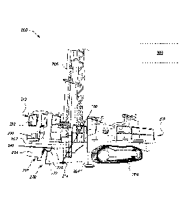
FIG. 1 shows a drilling system according to one or more
embodiments of the disclosed subject matter.
FIG. 2 is a block diagram of a control system according to one or
more embodiments of the disclosed subject matter.
25 FIG. 3 is
a basic flow chart of a method according to one or more
embodiments of the disclosed subject matter.
CA 03201562 2023- 6-7
WO 2022/132348
PCT/US2021/058882
-4-
Detailed Description
The present disclosure relates to identification of groundwater, and
more particularly to systems, methods, and apparatuses for identifying
groundwater during rock drill cutting.
5 FIG 1
illustrates a drilling machine 200 in accordance with one or
more embodiments of the present disclosure. The drilling machine 200 can be
configured to operate on a worksite such as a construction site or a mining
site.
The drilling machine 200 can be manually, autonomously, or semi-autonomously
operated. Moreover, the drilling machine 200 can be locally controlled at the
10 worksite via operator input (manual and/or wireless) and/or remotely
controlled
from a location remote from the worksite, such as a back office system 300.
The
communication between the drilling machine 200 and the back office system 300
may be via wired and/or wireless systems.
The drilling machine 200 can include a frame 202 supported on a
15 transport mechanism, such as crawler tracks 204 in a rear portion 219 of
the
drilling machine 200, as illustrated in FIG. 1, for instance. The drilling
machine
200 may further include a mast 206 mounted on the frame 202 and supported
about a pivot. The drilling machine 200 may also include jacks 208 that may be
extended to support (including level) the drilling machine 200 during a
drilling
20 operation. The drilling machine 200 may further include a cabin 210. An
operator control interface 212 may be provided in the cabin 210 to control at
least
some operations of the drilling machine 200. The operator control interface
212
may include a display device to display to an operator visual data of
operating
conditions of the drilling machine 200. Discussed in more detail below, the
25 visual data may include information regarding identification of
groundwater
during the drilling operation of the drilling machine 200. Also discussed in
more
detail below, such groundwater identification information may include a
location
(e.g., depth) within a drill hole 100 at which the groundwater is identified.
The drilling machine 200 can also include a work tool 214,
30 supported by the mast 206, for performing the drilling operation. The
work tool
214 may include a rotary drill bit (e g , a rotary tricone drill bit) The work
tool
CA 03201562 2023- 6-7
WO 2022/132348
PCT/US2021/058882
-5-
214 may be rotated via one or more electric motors of the drilling machine 200
or
via a hydraulic system of the drilling machine 200. Thus, the drilling machine
200 may be characterized as an electric drilling machine (full or partial
electric)
or a hydraulic drilling machine (e.g., a hydraulic rock drill).
5 According to one or more embodiments, the drilling machine 200
may include a dust containment system 218 provided below the frame 202. The
dust containment system 218 can define an enclosure 220 for covering the work
tool 214 between one or more walls 222 and a dust curtain 224. In an
embodiment, a plurality of dust curtains 224 may define the enclosure for
10 covering the work tool 214. The drilling operation can be performed with
the
work tool 214 within the enclosure 220 of the dust containment system 218.
The dust containment system 218 may include one or more
actuators 226 attached to the frame 202 of the drilling machine 200. The one
or
more actuators 226 may be connected to the dust curtain 224. Based on the
15 movement of the actuators 226, the height of the dust curtain 224 with
respect to
a ground surface of the worksite can be adjusted. In accordance with an
embodiment, the actuators 226 may be hydraulically operated. However, the
actuators 226 may alternatively be operated pneumatically or mechanically,
based
on the particular configuration of drilling machine 200.
20 The drilling machine 200 may also include a dust suppression
system 230. The dust suppression system 230 can be configured to control the
amount of dust generated and released during a drilling operation performed by
the drilling machine 200. According to one or more embodiments, the dust
suppression system 230 can be configured to automatically detect and predict
25 dust levels generated by the drilling operation of the drilling machine
200 at the
worksite.
The dust containment system 218 and/or the dust suppression
system 230 may be referred to as a dust management system 218/230. Discussed
in more detail below, either or both parts of the dust management system
218/230
30 can be controlled based on identification of groundwater in the drill
hole 100
during the drilling operation of the drilling machine 200. For instance, the
dust
CA 03201562 2023- 6-7
WO 2022/132348
PCT/US2021/058882
-6-
suppression system 230 may be turned off in response to identification of
groundwater in the drill hole 100 during the drilling operation of the
drilling
machine 200. To be clear, drilling machines, such as drilling machine 200,
according to one or more embodiments of the disclosed subject matter may not
5 include the dust containment system 218 or the like and/or may not
include the
dust suppression system 230 or the like. That is, according to one or more
embodiments, the drilling machine without the dust containment system 218
and/or the dust suppression system 230 may detect and determine groundwater
location within the drill hole 100 without regard to functionality of the dust
10 containment system 218 and/or the dust suppression system 230.
A controller 250 of the drilling machine 200, which may represent
one or more controllers, can be operatively provided to control various
components of the drilling machine 200. For instance, the controller 250 can
control the drilling operation, for instance, the rotation rate of the work
tool 214,
15 the rate or penetration of the work tool 214, retraction of the work
tool 214, etc.
The controller 250 can also control operation of the jacks 208, the crawler
tracks
204, the dust containment system 218, and/or the dust suppression system 230.
Optionally, the controller 250 can be operatively coupled to the operator
control
interface 212. Thus, some or all of such control can be via operator input to
the
20 operator control interface 212. Control information pertaining to the
operation of
the drilling machine 200 can also be sent to the operator control interface
212 via
the controller 250.
One or more water or moisture sensors 240 can be provided. Each
sensor 240 can be an optical or laser sensor aimed at and/or adjacent a collar
of
25 the drill hole 100 (as diagrammatically shown by the dashed arrow in
FIG. 1).
According to one or more embodiments, the sensor 240 can be located below the
frame 202 of the drilling machine 200. In any case, the sensor 240 can be
provided to measure or detect water content at the collar of the drill hole
100 as
the drilling machine 200 performs a drilling operation. More specifically, the
30 sensor 240 can measure water content of cuttings (e.g., rock cuttings or
chips)
exiting the drill hole 100 as the cuttings are flushed from the drill hole
100. The
CA 03201562 2023- 6-7
WO 2022/132348
PCT/US2021/058882
-7-
cuttings may be expelled from the drill hole 100 using air (e.g., a stream of
compressed air) output at a bottom end of the work tool 214 (e.g., a bottom
face
of a rotary drill bit) as the work tool 214 progressively drills the drill
hole 100.
According to one or more embodiments, the sensor 240 may measure
5 characteristics associated with a refractory of light breakdown from the
cuttings.
Different refractive ranges may be associated with groundwater
coating the cuttings versus either no water coating the cuttings or a
relatively
small amount of water coating the cuttings. The relatively small amount of
water
may be introduced into the drill hole 100 from a water injection system 245
10 during the drilling operation of the drilling machine 200. Thus, the
sensor 240
may be sensitive enough to sense changes in water content to detect that the
change is representative of the work tool 214 intersecting groundwater as the
drilling machine 200 drills the drill hole 100, even if water is being
introduced or
has been introduced into the drill hole 100 from the water injection system
245.
15 The sensor 240 can also detect, or be used to determine, an amount
(e.g., volume)
of groundwater in the drill hole 100 associated with the cuttings exiting the
drill
hole 100. Thus, the sensor 240 can measure changes in moisture or water
content
of the cuttings exiting the drill hole 100 to identify existence of
groundwater at
particular locations (e.g., depths) in the drill hole 100. Such measurements
can
20 also identify locations (e.g., depths) in the drill hole 100 where
groundwater is
not identified, including transitions to and from groundwater locations
relative to
dry locations within the drill hole 100.
Generally, the drilling machine 200 can be configured to drill the
drill hole 100 in earthen material below the drilling machine 200 using the
work
25 tool 214 and corresponding components (e.g., drill string, etc.). The
drill hole
100 may be referred to as a blasthole 100 or a probe hole 100 and can be
vertical
or substantially vertical. An initial opening of the drill hole 100 may be
referred
to as a collar. After the drill hole 100 has been drilled and the drilling
machine 200 moved from over the drill hole (and optionally after all drill
holes or
30 a subset of drill holes at the worksite have been completed), explosives
can be
placed at predetermined locations within one or more (e.g., all) of the drill
holes
CA 03201562 2023- 6-7
WO 2022/132348
PCT/US2021/058882
-8-
100. The path of the cuttings from the rock-work tool 214 interface to exiting
the
drill hole 100 can be substantially instantaneous, at least from the
perspective of
an operator of the drilling machine 200. For instance, the cuttings may exit
the
drill hole 100 at or about at a velocity of 5000 ft/min. Hence, the accuracy
of
5 measurements regarding the locations of the cuttings from within the
drill hole
100 as described herein can be according to millimeter accuracy, for instance,
within at or about 1 mm to at or about 2 mm.
FIG. 2 schematically illustrates the controller 250 associated with
the drilling machine 200 according to one or more embodiments of the present
10 disclosure. It should be understood that the controller 250 can be
included in the
drilling machine 200 (e.g., mounted on a component of the drilling machine
200),
such as shown in FIG. 1. Additionally or alternatively, the controller 250, or
portion thereof, may be a separate component positioned remote from the
drilling
machine 200 (e.g., as part of a remote control device or station for the
drilling
15 machine 200, such as the back office system 300).
The controller 250 can include an electronic processor 260, a non-
transitory computer-readable media 265, and an input/output interface 270. The
electronic processor 260, the computer-readable media 265, and the
input/output
interface 270 can be connected by one or more control and/or data buses that
20 allow the components to communicate. It should be understood that the
functionality of the controller 250 can be combined with one or more other
controllers to perform additional functionality. Additionally or
alternatively, the
functionality of the controller 250 can be distributed among more than one
controller.
25 The
computer-readable media 265 can store program instructions
and data. The electronic processor 260 can be configured to retrieve
instructions
from the computer-readable media 265 and execute, among other things, the
instructions to perform the control processes and methods described herein.
The
input/output interface 270 can transmit data from the controller 250 to
systems,
30 networks, and devices located remotely or onboard the drilling machine
200 (e.g.,
over one or more wired and/or wireless connections). The input/output
interface
CA 03201562 2023- 6-7
WO 2022/132348
PCT/US2021/058882
-9-
270 can also receive data from systems, networks, and devices located remotely
or onboard the drilling machine 200 (e.g., over one or more wired and/or
wireless
connections). The input/output interface 270 can provide received data to the
electronic processor 260 and, in some embodiments, can also store received
data
5 to the computer-readable media 265.
As illustrated in FIG. 2, the controller 250 can communicate with
the operator control interface 212. As noted above, the operator control
interface
212 can allow the operator to control various operations of the drilling
machine
200, including some or all aspects of the drilling operation of the drilling
machine
10 200. As examples, the operator control interface 212 can include one or
more
operator-controlled input devices, such as graphical user interface(s),
joysticks,
levers, foot pedals, and other actuators. The operator control interface 212
can
also include a display device (which may provide the graphical user
interface(s)).
The display device may show various operating conditions of or associated with
15 the drilling machine 200.
Generally, the operator control interface 212 can be configured to
control the water injection system 245, the dust containment system 218,
and/or
the dust suppression system 230, at least in some respects. For example, the
operator control interface 212 can allow an operator to enter desired settings
for
20 dust suppression, such as water flow rate, water flow cutoff depth,
suction cutoff
depth, particulate limit (e.g., size and/or amount), etc. However, the
controller 250 may automatically control the water injection system 245, the
dust
containment system 218, and/or the dust suppression system 230, as discussed
in
more detail below, based on detection of groundwater in the drill hole 100.
The
25 operator control interface 212 can also output (e.g., display)
information
including a measured water tank level, a measured water flow rate, a water
flow
rate set point, a dust collector suction output, a dust collector suction set
point, a
measured particulate level, a particulate level set point, etc. pertaining to
the dust
management system 218/230 and/or the water injection system 245.
30 The
controller 250 can also communicate with a hole depth sensor
275. Generally, the hole depth sensor 275 can measure depth of the drill hole
100
CA 03201562 2023- 6-7
WO 2022/132348
PCT/US2021/058882
-10-
as the drill hole 100 is being drilled. As examples, such hole depth sensor
275
can sense position of the work tool 214 and/or a motor (e.g., electric motor)
driving the work tool 214 to determine depth of the work tool 214 and hence
the
drill hole 100 as the drill hole 100 is drilled. The controller 250 can use
depth
5 data from the hole depth sensor 275 to associate depth of the drill hole
100 with
location of identified groundwater.
A bit air exception sensor 280 may be provided to indicate a
blockage in the drill hole 100. Remedial actions may need to be taken (e.g.,
retract the work tool 214) to clear the blockage. Such action can be performed
10 manually via the operator control interface 212 or automatically using
the
controller 250, for instance.
The controller 250 can receive signals from the sensor 240. The
signals can be received in real time and can be representative of moisture or
water
content of cuttings exiting the drill hole 100 as the work tool 214 of the
drilling
15 machine 200 progressively drills the drill hole 100. Such drilling
operation of the
drilling machine 200 may be referred to as a rock cutting operation, since the
earthen material being drilled by the drilling machine 200 can be formed at
least
partially of rock.
The controller 250 can analyze the signals from the sensor(s) 240
20 in real time as the work tool 214 drills the drill hole 100. This can
include
analysis of water content data associated with the signals as the work tool
214
progresses in depth to identify that the work tool 214 has reached a water-
bearing
seam of earthen material (e.g., rock). Such identification can be referred to
as
determining existence of groundwater in the drill hole 100. According to one
or
25 more embodiments, the analysis can be performed continuously according
to
predetermined depth intervals as the work tool 214 progresses in the drill
hole
100. For instance, the predetermined depth intervals may on a millimeter
basis,
for instance, at or about 1 mm to at or about 2 mm.
The controller 250 may determine existence of groundwater when
30 the water content data associated with the signals from the sensor(s)
240 indicates
that a water content value of the cuttings increases by a predetermined amount
CA 03201562 2023- 6-7
WO 2022/132348
PCT/US2021/058882
- 11 -
relative to an immediately previous water content value of the cuttings
exiting the
drill hole 100. The predetermined amount may be according to a percentage
increase. Thus, the difference in moisture content can identify where the
drill
hole 100 intersects groundwater of a water-bearing seam. More than one
5 intersection can be identified in each drill hole 100. The drill hole
100, therefore,
may intersect multiple water-bearing seams in some cases. Distinct locations
of
identified groundwater within one drill hole 100 may be referred to herein as
instances of existence or presence of groundwater within the drill hole 100.
According to one or more embodiments, the immediately previous
10 water content value can be a non-zero value due to water introduced into
the drill
hole 100 from a source other than the water-bearing seam, such as water
provided
to the drill hole 100 by the water injection system 245. Such immediately
previous water content value may be a constant value in that water from the
water
injection system 245 can be provided at a constant rate. Alternatively, the
15 immediately previous water content value can be zero or substantially
zero,
meaning that the immediately previous cuttings correspond to no water from the
water injection system 245 being provided and lack of groundwater at the
immediately previous location within the drill hole 100.
The analysis by the controller 250 may also determine an amount
20 of water volume associated with the location in the drill hole 100 at
which
groundwater is determined to exist. The determined amount of water volume
may be determined based on the amount of increase in the water content value
discussed above. Such water volume may represent or may be processed by the
controller 250 to determine an amount of water volume added or estimated to be
25 added to the drill hole 100 by the portion of the water-bearing earthen
system. In
the case of multiple distinct locations of groundwater for one drill hole 100,
i.e.,
multiple water-bearing seams, the controller 250 record how much water volume
each groundwater location individually provides to the drill hole 100.
Alternatively, the controller 250 may keep a running total of the total amount
of
30 added water or alternatively, determine the total amount of added water
upon
completion of the drill hole 100.
CA 03201562 2023- 6-7
WO 2022/132348
PCT/US2021/058882
-12-
Existence of groundwater within the drill hole 100 can be
associated with a corresponding location or locations within the drill hole
100.
The controller 250 can perform such association in real time as the drilling
machine 200 drills the drill hole 100. Location (e.g., depth) data from the
hole
5 depth sensor 275 can be used to identify position of the bottom of the
work tool
214 in the drill hole 100 and hence from the location in the drill hole 100
from
where the cuttings originated.
The association of groundwater identification with location in the
drill hole 100 may be characterized as mapping or logging the drill hole 100
in
10 terms of groundwater locations within the drill hole 100. Such mapping
or
logging may also identify locations where groundwater is not identified to be
present when drilling the drill hole 100. Thus, the association can represent
depth
or depths within the drill hole 100 at which the work tool 214 intersected
groundwater. In this regard, the mapping or logging can also include location
of
15 transition to and transition from the groundwater seam. For instance,
the
mapping or logging can include one or more intersections in the drill hole 100
between dry rock and wet rock corresponding to existence of groundwater. The
logging or mapping can also identify an amount of water volume associated with
each existence of groundwater. Such amount of water volume may be
20 representative of how much water the water-bearing seam provides to the
drill
hole 100.
According to one or more embodiments, the controller 250 can
reduce an amount of water introduced into the drill hole 100 by the water
injection system 245 when the existence of groundwater is determined from the
25 analysis of the water content of the cuttings. For example, the
controller 250 can
reduce the amount of water to zero or a value less than a value prior when
groundwater is identified during the drilling operation. Optionally, the
controller
250 can reduce the amount of water supplied to the drill hole 100 by the water
injection system 245 each time groundwater is identified when drilling the
drill
30 hole 100. Thus, in a case where the work tool 214 intersects multiple
water-
bearing seams separated by a non-water-bearing seam when drilling the drill
hole
CA 03201562 2023- 6-7
WO 2022/132348
PCT/US2021/058882
-13-
100, the water from the water injection system 245 may be reduced upon the
work tool 214 reaching the first water-bearing seam, increased after the work
tool
214 exits the first water-bearing seam, and reduced again upon the work tool
214
reaching the second water-bearing seam. The intervening location in the drill
5 hole 100 associated with no groundwater may be referred to as a third
depth
within the drill hole 100 separating first and second depths associated with
existence of groundwater within the drill hole 100 The reduction of water
supplied from the water injection system 245 can be maintained until an
identified transition from the groundwater location to the non-groundwater
10 location in the drill hole 100 or a predetermined time after the
transition.
Optionally, the controller 250 may control some or all of the dust
management system 218/230 when the existence of groundwater is identified in
the drill hole 100. For instance, the controller 250 may turn off the dust
suppression system 230 or lower the suction speed thereof responsive to a
15 determination of existence of groundwater in the drill hole 100. Such
control of
the dust management system 218/230 can be maintained until an identified
transition from the groundwater location to a non-groundwater location in the
drill hole 100 or a predetermined time after the transition.
Information regarding the groundwater determination may be
20 provided to the operator via the operator control interface 212, for
instance, on a
display device thereof. Such groundwater determination information can be
provided in real time to the operator control interface 212, including
responsive
to the determination of groundwater existence in the drill hole 100.
Alternatively, such groundwater determination information can be continuously
25 output by the operator control interface 212 and can include a mapping
or logging
of the groundwater determinations versus location in the drill hole 100 as the
drilling machine 200 drills the drill hole 100. Output of such groundwater
determination information may be used by the operator to control the drilling
machine 200 or portions thereof, such as the dust management system 218/230
30 and/or the water injection system 245. Alternatively, as noted above,
such
CA 03201562 2023- 6-7
WO 2022/132348
PCT/US2021/058882
-14-
systems can be automatically controlled by the controller 250 based on the
determination of existence of groundwater within the drill hole 100.
Groundwater location information can be offloaded from the
drilling machine 200, for instance, to the back office system 300. Such
5 offloading can be via a wired and/or wireless network and can be
performed after
(e.g., upon) completion of the drilling operation to drill the drill hole 100.
According to one or more embodiments, the groundwater location information
can be offloaded as a mapping or a log, such as described above. Optionally,
the
Groundwater location information can be formatted in a batch file and
offloaded.
10 Industrial Applicability
As noted above, the present disclosure relates to identification of
groundwater, and more particularly to systems, methods, and apparatuses for
identifying groundwater during rock drill cutting.
Generally, systems, methods, and apparatuses can identify
15 groundwater as a drilling machine drills a drill hole, such as drilling
machine 200
drilling drill hole 100. Presence (or not) of groundwater can be continuously
monitored as the drilling machine 200 drills the drill hole 100 using one or
more
groundwater or moisture sensors 240 to detect moisture or water content of
cuttings from the drill hole 100. Such data from the sensor(s) 240 can be
20 processed, for instance, by a controller such as controller 250, to
determine the
presence (or not) of groundwater within the drill hole 100, as the drilling
machine
200 drills the drill hole 100.
Location of the end of the work tool 214, as sensed determined
position signaling from the hole depth sensor 275, for instance, can be used
to
25 identify a location within the drill hole 100 from which the cuttings
associated
with the determined groundwater came and hence location in the drill hole 100
where the work tool 214 met groundwater. A mapping or logging of the drill
hole 100 can be generated, for instance, using the controller 250, with the
location or locations where the presence of groundwater is identified. After
30 completion of drilling the drill hole 100, the completed mapping or
logging of the
CA 03201562 2023- 6-7
WO 2022/132348
PCT/US2021/058882
-15-
drill hole 100 can be offloaded from the drilling machine 200, for instance,
to a
back office system such as back office system 300. The mapping or logging
information may be offloaded in a batch file.
FIG 3 shows a block diagram of a method 400 according to one
5 or more embodiments off the disclosed subject matter. Some or all of the
method
400 can be performed using a non-transitory computer-readable storage medium
having stored thereon instructions that, when executed by one or more
processors
(e.g., electronic processor 260 of the controller 250), cause the one or more
processors to perform the method 400.
10 The method 400, at 402, can receive water or moisture content
data from one or more water or moisture sensors, such as sensor 240. Such data
can be received in real time, for instance, by the controller 250. The data
can be
representative of water or moisture content of cuttings at a collar of the
drill hole
100 as the cuttings are expelled from the drill hole 100 while the drilling
machine
15 200 progressively drills the drill hole 100.
At 404, the method 400 can process the water content data to
determine existence or not of groundwater within the drill hole 100
corresponding to a location within the drill hole 100 from where the cuttings
came Such processing can be performed by the controller 250 in real time. The
20 determination of whether groundwater exists or not can include
determining
when a water content value of the cuttings has increased by a predetermined
amount, for instance, relative to an immediately previous water content value
of
the cuttings. The increase in water content can also be used to determine an
amount of water (e.g., volume) associated with the determined groundwater in
25 the drill hole 100. The determined amount of water can represent the
amount of
water supplied to the drill hole 100 by the corresponding water-bearing seam.
At 406, the method 400 can identify location of the identified
groundwater within the drill hole 100. Such processing can be performed by the
controller 250 in real time. Operation 406 can also involve identify locations
in
30 the drill hole 100 without groundwater. Such identification may be
referred to as
association of the groundwater with location within the drill hole 100.
According
CA 03201562 2023- 6-7
WO 2022/132348
PCT/US2021/058882
-16-
to one or more embodiments, the association can be by way of logging or
mapping the existence of groundwater or not relative to location within the
drill
hole 100 in real time as the drilling machine 200 drills the drill hole 100.
The
mapping or logging can be stored in memory of the controller 250. Optionally,
5 such location association can include association of a water amount
(e.g., water
volume) associated with location of the identified groundwater within the
drill
hole 100.
At operation 408 the mapping or logging information can be
offloaded from the drilling machine 200. The mapping or logging information
10 can be offloaded after (e.g., upon) completion of the drilling of the
drill hole 100.
According to one or more embodiments, the offloading can be from the drilling
machine 200 to the back office system 300.
The operations 402-408 can be performed for one or more
additional drill holes 100. Groundwater location data pertaining to a set
drill
15 holes 100 at the worksite can be mapped, for instance, by the back
office system
300, to map the terrain of the worksite and corresponding groundwater or
moisture for the terrain. Such mapping can be used for the management and
placement of blast charges in the drill holes 100. According to one or more
embodiments, such mapping of groundwater for the set of drill holes 100 can
20 include interpolation of groundwater location estimates between the
drill holes
100.
As used herein, the term "circuitry" can refer to any or all of the
following: (a) hardware-only circuit implementations (such as implementations
in
only analog and/or digital circuitry); (b) to combinations of circuits and
software
25 (and/or firmware), such as (as applicable): (i) a combination of
processor(s) or
(ii) portions of processor(s)/software (including digital signal
processor(s)),
software and memory(ies) that work together to cause an apparatus, such as a
mobile phone or server, to perform various functions); and (c) to circuits,
such as
a microprocessor(s) or a portion of a microprocessor(s), that require software
or
30 firmware for operation, even if the software or firmware is not
physically present.
CA 03201562 2023- 6-7
WO 2022/132348
PCT/US2021/058882
-17-
While aspects of the present disclosure have been particularly
shown and described with reference to the embodiments above, it will be
understood by those skilled in the art that various additional embodiments may
be
contemplated by the modification of the disclosed machines, assemblies,
systems,
and methods without departing from the spirit and scope of what is disclosed.
Such embodiments should be understood to fall within the scope of the present
disclosure as determined based upon the claims and any equivalents thereof
CA 03201562 2023- 6-7