Note: Descriptions are shown in the official language in which they were submitted.
WO 2022/245823
PCT/US2022/029633
COMPUTER VISION SYSTEMS AND METHODS FOR DETERMINING STRUCTURE
FEATURES FROM POINT CLOUD DATA USING NEURAL NETWORKS
SPECIFICATION
BACKGROUND
RELATED APPLICATIONS
100011 The present application claims the benefit of priority of
U.S. Provisional
Application Serial No. 63/189,371 filed on May 17, 2021, the entire disclosure
of which is
expressly incorporated herein by reference.
TECHNICAL FIELD
100021 The present disclosure relates generally to the field of
computer modeling of
structures. More particularly, the present disclosure relates to computer
vision systems and
methods for determining structure features from point cloud data using neural
networks.
RELATED ART
100031 Accurate and rapid identification and depiction of objects
from digital imagery (e.g.,
aerial images, satellite images, LiDAR, point clouds, three-dimensional (3D)
images, etc.) is
increasingly important for a variety of applications. For example, information
related to various
objects of structures (e.g., structure faces, roof structures, etc.) and/or
objects proximate to the
structures (e.g., trees, pools, decks, etc.) and the features thereof (e.g.,
doors, walls, slope, tree
cover, dimensions, etc.) is often used by construction professionals to
specify materials and
associated costs for both newly-constructed structures, as well as for
replacing and upgrading
existing structures. Further, in the insurance industry, accurate information
about the objects of
and/or proximate to structures and the features of these objects can be used
to determine the proper
1
CA 03219113 2023- 11- 15
WO 2022/245823
PCT/US2022/029633
costs for insuring the structures. For example, a condition of a roof
structure of a structure and
whether the structure is proximate to a pool are valuable sources of
information.
[0004] Various software systems have been implemented to process
point cloud data to
determine and extract objects of and/or proximate to structures and the
features of these objects
from the point cloud data. However, these systems can be computationally
expensive, time
intensive (e.g., manually extracting structure features from point cloud
data), unfeasible for
complex structures and the features thereof, and have drawbacks rendering the
systems unreliable,
such as noisy or incomplete point cloud data. Moreover, such systems can
require manual
inspection of the structures by humans to accurately determine structure
features. For example, a
roof structure often requires manual inspection to determine roof structure
features including, but
not limited to, damage, slope, vents, and skylights. As such, the ability to
automatically determine
and extract features of a roof structure, without first performing manual
inspection of the surfaces
and features of the roof structure, is a powerful tool.
[0005] Thus, what would be desirable is a system that leverages
one or more neural
networks to automatically and efficiently determine and extract structure
features from point cloud
data without requiring manual inspection of the structure. Accordingly, the
computer vision
systems and methods disclosed herein solve these and other needs.
2
CA 03219113 2023- 11- 15
WO 2022/245823
PCT/US2022/029633
SUMMARY
100061 The present disclosure relates to computer vision systems
and methods for
determining structure features from point cloud data using neural networks.
The system obtains
point cloud data of a structure or a property parcel having a structure
present therein from a
database. In particular, the system receives a geospatial region of interest
(ROT), an address, or
georeferenced coordinates specified by a user and obtains point cloud data
associated with the
geospatial ROT from the database. The system can preprocess the obtained point
cloud data to
generate another point cloud or 3D representation derived from the point cloud
data by performing
specific preprocessing steps including, but not limited to, spatial cropping
and/or transformation,
down sampling, up sampling, and filtering. The system can also preprocess
point features to
generate and/or obtain any new features thereof. Then, the system extracts a
structure and/or
feature of the structure from the point cloud data utilizing one or more
neural networks. The
system determines at least one attribute of the extracted structure and/or
feature of the structure
utilizing the one or more neural networks. The system can utilize one or more
neural networks to
perform tasks including, but not limited to, detection, classification,
segmentation, regression, and
optimization. The system can refine and/or transform the at least one
attribute of the extracted
structure and/or feature of the structure.
3
CA 03219113 2023- 11- 15
WO 2022/245823
PCT/US2022/029633
BRIEF DESCRIPTION OF THE DRAWINGS
100071 The foregoing features of the invention will be apparent
from the following Detailed
Description of the Invention, taken in connection with the accompanying
drawings, in which:
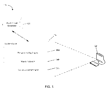
100081 FIG. 1 is a diagram illustrating an embodiment of the
system of the present
disclosure;
100091 FIG. 2 is a flowchart illustrating overall processing
steps carried out by the system
of the present disclosure;
100101 FIG. 3 is a flowchart illustrating step 52 of FIG. 2 in
greater detail;
100111 FIG. 4A is a diagram illustrating a point cloud having a
structure present therein;
100121 FIGS. 4B-D are diagrams illustrating respective attributes
of an extracted roof
structure of the structure present in the point cloud of FIG. 4A;
100131 FIG. 5A is a diagram illustrating another point cloud
having a structure present
therein;
100141 FIG. 5B is a diagram illustrating scene segmentation of
the point cloud of FIG. 5A;
100151 FIGS. 5C-D are diagrams illustrating respective attributes
of an extracted roof
structure of the structure present in the point cloud of FIG. 5A; and
100161 FIG. 6 is a diagram illustrating another embodiment of the
system of the present
disclosure.
4
CA 03219113 2023- 11- 15
WO 2022/245823
PCT/US2022/029633
DETAILED DESCRIPTION
100171 The present disclosure relates to systems and methods for
determining property
features from point cloud data using neural networks, as described in detail
below in connection
with FIGS. 1-6.
100181 Turning to the drawings, FIG. 1 is a diagram illustrating
an embodiment of the
system 10 of the present disclosure. The system 10 could be embodied as a
central processing unit
12 (processor) in communication with a database 14. The processor 12 could
include, but is not
limited to, a computer system, a server, a personal computer, a cloud
computing device, a smart
phone, or any other suitable device programmed to carry out the processes
disclosed herein. The
system 10 could retrieve point cloud data from the database 14 indicative of a
structure or a
property parcel having a structure present therein.
100191 The database 14 could store one or more 3D representations
of an imaged property
parcel or location (including structures at the property parcel or location),
such as point clouds,
LiDAR files, etc., and the system 10 could retrieve such 3D representations
from the database 14
and operate with these 3D representations. Alternatively, the database 14
could store digital
images and/or digital image datasets including ground images, aerial images,
satellite images, etc.
where the digital images and/or digital image datasets could include, but are
not limited to, images
of residential and commercial buildings (e.g., structures). Additionally, the
system 10 could
generate one or more 3D representations of an imaged property parcel or
location (including
structures at the property parcel or location), such as point clouds, LiDAR
files, etc. based on the
digital images and/or digital image datasets. As such, by the terms "imagery"
and "image" as used
herein, it is meant not only 3D imagery and computer-generated imagery,
including, but not limited
CA 03219113 2023- 11- 15
WO 2022/245823
PCT/US2022/029633
to, LiDAR, point clouds, 3D images, etc., but also optical imagery (including
aerial and satellite
imagery).
100201 The processor 12 executes system code 16 which utilizes
one or more neural
networks to determine and extract features of a structure and corresponding
roof structure present
therein from point cloud data obtained from the database 14. In particular,
the system 10 can
utilize one or more neural networks to process a point cloud representation of
a property parcel
having a structure present therein to perform tasks including, but not limited
to, detection,
cl as si fi cation, segmentation, regression, and optimization.
100211 For example, the system 10 can perform object detection to
estimate a location of an
object of interest including, but not limited to, a structure wall face, a
roof structure face, a segment,
an edge and a vertex and/or estimate a wireframe or mesh model of the
structure. The system 10
can perform point cloud classification to estimate probabilities that a point
cloud belongs to a class
or classes to determine if the point cloud includes a structure, determine if
the structure is damaged,
classify a type of the structure (e.g., residential or commercial) and
classify objects of and/or
proximate to the structure (e.g., a pool, a deck, a chimney, etc.). In another
example, the system 10
can perform segmentation including tasks such as, but not limited to, semantic
segmentation to
estimate probabilities that each point belongs to a class and/or object (e.g.,
a tree, a pool, a structure
wall face, a roof structure face, a chimney, a ground field, a segment, a
segment type, and a vertex)
and instance segmentation to estimate if a point belongs to a particular
feature (e.g., an instance) of
a structure or roof structure to differentiate points belonging to different
structures or roof structure
faces. The system 10 can also perform regression tasks to estimate values of
each point (e.g., a 3D
normal vector value, a curvature value, etc.) or estimate roof structure
features (e.g., area,
dimensions, slopes, condition, heights, edge lengths by type, etc.). In
another example, the system
6
CA 03219113 2023- 11- 15
WO 2022/245823
PCT/US2022/029633
can perform optimization tasks to improve a point cloud including, but not
limited to, increasing
a density or resolution of the point cloud, providing missing point cloud data
that is not visible in
the point cloud, and filtering noise. The outputs generated by the neural
network(s) can be used to
characterize the property parcel and the structure present therein and/or can
be refined and/or
transformed by the system 10 or another system to obtain additional features
of the property parcel
and the structure present therein.
100221 The system code 16 (non-transitory, computer-readable
instructions) is stored on a
computer-readable medium and executable by the hardware processor 12 or one or
more computer
systems. The code 16 could include various custom-written software modules
that carry out the
steps/processes discussed herein, and could include, but is not limited to, a
pre-processing engine
18a, a neural network 18b and a post-processing engine 18c. The code 16 could
be programmed
using any suitable programming languages including, but not limited to, C,
C++, C#, Java, Python
or any other suitable language. Additionally, the code 16 could be distributed
across multiple
computer systems in communication with each other over a communications
network, and/or
stored and executed on a cloud computing platform and remotely accessed by a
computer system in
communication with the cloud platform. The code 16 could communicate with the
database 14
which could be stored on the same computer system as the code 16, or on one or
more other
computer systems in communication with the code 16.
100231 Still further, the system 10 could be embodied as a
customized hardware component
such as a field-programmable gate array ("FPGA"), application-specific
integrated circuit
("ASIC"), embedded system, or other customized hardware components without
departing from
the spirit or scope of the present disclosure. It should be understood that
FIG. 1 is only one
7
CA 03219113 2023- 11- 15
WO 2022/245823
PCT/US2022/029633
potential configuration, and the system 10 of the present disclosure can be
implemented using a
number of different configurations.
100241 FIG. 2 is a flowchart illustrating overall processing
steps 50 carried out by the
system 10 of the present disclosure. Beginning in step 52, the system 10
obtains point cloud data
of a structure or a property parcel having a structure present therein from
the database 14. FIG. 3 is
a flowchart illustrating step 52 of FIG. 2 in greater detail. Beginning in
step 60, the system 10
receives a geospatial region of interest (ROI) specified by a user. For
example, a user can input
latitude and longitude coordinates of an ROI. Alternatively, a user can input
an address of a
desired property parcel or structure, georeferenced coordinates, and/or a
world point of an ROI.
The geospatial ROI can be represented by a generic polygon enclosing a
geocoding point indicative
of the address or the world point The region can be of interest to the user
because of one or more
structures present in the region. A property parcel included within the ROI
can be selected based
on the geocoding point. As discussed in further detail below, a neural network
can be applied over
the area of the parcel to detect a structure or a plurality of structures
situated thereon.
100251 The geospatial ROI can also be represented as a polygon
bounded by latitude and
longitude coordinates. In a first example, the bound can be a rectangle or any
other shape centered
on a postal address. In a second example, the bound can be determined from
survey data of
property parcel boundaries. In a third example, the bound can be determined
from a selection of
the user (e.g., in a geospatial mapping interface). Those skilled in the art
would understand that
other methods can be used to determine the bound of the polygon. The ROI may
be represented in
any computer format, such as, for example, well-known text ("WKT") data, TeX
data, HTML data,
XML data, etc. For example, a WKT polygon can comprise one or more computed
independent
world areas based on the detected structure in the parcel.
8
CA 03219113 2023- 11- 15
WO 2022/245823
PCT/US2022/029633
100261 In step 62, after the user inputs the geospatial ROT, the
system 10 obtains point
cloud data of a structure or a property parcel having a structure present
therein corresponding to the
geospatial ROT from the database 14. As mentioned above, the system 10 could
retrieve 3D
representations of an imaged property parcel or location (including structures
at the property parcel
or location), such as point clouds, LiDAR files, etc. from the database 14 and
operate with these
3D representations. Alternatively, the system 10 could retrieve digital images
and/or digital image
datasets including ground images, aerial images, satellite images, etc. from
the database 14 where
the digital images and/or digital image datasets could include, but are not
limited to, images of
residential and commercial buildings (e.g., structures). Those skilled in the
art would understand
that any type of image can be captured by any type of image capture source.
For example, the
aerial images can be captured by image capture sources including, but not
limited to, a plane, a
helicopter, a paraglider, a satellite, or an unmanned aerial vehicle (UAV).
The system 10 could
generate one or more 3D representations of an imaged property parcel or
location (including
structures at the property parcel or location), such as point clouds, LiDAR
files, etc. based on the
digital images and/or digital image datasets.
100271 Returning to FIG. 2, in step 54 the system 10 determines
whether to preprocess the
obtained point cloud data. If the system 10 determines to preprocess the point
cloud data, then the
system 10 utilizes a main neural network, one or more additional neural
networks or any other
suitable method to perform specific preprocessing steps to generate another
point cloud or 3D
representation derived from the point cloud data. For example, the system 10
can perform specific
preprocessing steps including, but not limited to, one or more of: spatially
cropping the point cloud
based on a two-dimensional (2D) or 3D ROT; spatially transforming (e.g.,
rotating, translating,
scaling, etc.) the point cloud; down sampling the point cloud to reduce a
number of points, obtain a
9
CA 03219113 2023- 11- 15
WO 2022/245823
PCT/US2022/029633
simplified point set representing the same ROT, and/or remove redundant
points; up sampling the
point cloud to increase a number of points, point density, and/or resolution,
or fill empty regions;
filtering the point cloud to remove outlier points and/or reduce noise;
projecting the point cloud
onto an image to obtain a 2D representation; and/or obtaining a voxel grid
representation. In
addition, the system 10 can preprocess point features to generate and/or
obtain any new features
thereof (e.g., spatial coordinates or normalized color values). It should be
understood that the
system 10 can perform one or more of the aforementioned preprocessing steps in
any particular
order. Alternatively, if the system 10 determines not to preprocess the point
cloud data, then the
process proceeds to step 56.
100281 In step 56, the system 10 extracts a structure and/or
feature of the structure from the
point cloud data utilizing one or more neural networks. For example, the
system 10 can utilize one
or more neural networks including, but not limited to, a 3D convolutional
neural network (CNN)
applicable to a voxelized point cloud representation (e.g., sparse or dense);
a PointNet-like network
or graph based network (e.g., a dynamic graph CNN) applicable directly to
points, or a 2D CNN
applicable to a 2D projection of the point cloud data. It should be understood
that the system 10
can extract features for each point of the point cloud data and/or for an
entirety of the point cloud
(e.g., a point set) by utilizing the one or more neural networks.
Additionally, the system 10 can
optimize parameters of a neural network for performing a target task by
utilizing, among other data
points, a high quality 3D structure model or a point cloud labeled via a
structure model, an image, a
2D projection, or human intervention (e.g., directly or indirectly utilizing
previously labeled
images).
CA 03219113 2023- 11- 15
WO 2022/245823
PCT/US2022/029633
100291 In step 58, the system 10 determines at least one
attribute of the extracted structure
and/or feature of the structure utilizing the one or more neural networks. The
system 10 can utilize
one or more neural networks to perform tasks including, but not limited to,
detection, classification,
segmentation, regression, and optimization as described in more detail below
and as illustrated in
connection with FIGS. 4A-D and 5A-D. It should be understood that the system
10 can utilize any
neural network suitable for performing the foregoing tasks.
100301 The system 10 can perform object detection to estimate a
location of a structure and
the objects thereof (e.g., a structure wall face, vertex, or edge) and a
bounding box enclosing the
structure and/or different building-related structures (e.g., a roof
structure) and the objects thereof
(e.g., a roof structure face, segment, vertex, or edge). The system 10 can
also perform point cloud
classification to estimate probabilities that a point cloud belongs to a class
or classes. The class can
be obtained from the estimated probability values by utilizing an argmax
operation or by applying
probability thresholds. It should be understood that point cloud
classification tasks can include, but
are not limited to, determining if the point cloud includes a structure and,
if so, classifying a type of
the structure (e.g., residential or commercial), determining if the structure
is damaged and, if so,
classifying a type and severity of the damage to the structure, and
classifying objects of and/or
proximate to the structure (e.g., a chimney, rain gutters, a skylight, a pool,
a deck, a tree, a
playground, etc.).
100311 The system 10 can perform segmentation to estimate
probabilities that each point
belongs to a class and/or object instance. The class can be obtained from the
estimated probability
values by utilizing an argmax operation or by applying probability thresholds.
It should be
understood that segmentation tasks can include, but are not limited to, scene
object segmentation to
determine if a point belongs to a structure wall, a roof structure, the ground
(e.g., ground field
11
CA 03219113 2023- 11- 15
WO 2022/245823
PCT/US2022/029633
segmentation to determine a roof structure relative height), a property parcel
object (e.g., tree
segmentation to estimate tree coverage and proximity), and road segmentation;
roof segmentation
to determine if a point belongs to a roof structure face, edge or vertex, a
type of the roof structure
edge or vertex (e.g., an cave, a rake, a ridge, a valley, a hip, etc.), and if
a point belongs to a roof
structure object (e.g., a chimney, a solar panel, etc.); roof face
segmentation to extract and
differentiate roof structure faces; and roof instance segmentation to segment
different roof structure
types (e.g., gable, flat, barrel-vaulted, etc.) of a roof structure.
[0032] The system 10 can perform regression tasks to estimate
values of each point (e.g., a
3D normal vector value, a curvature value, etc.) or estimate roof structure
features (e.g., area,
dimensions, slopes, condition, heights, edge lengths by type, etc.). The
system 10 can also perform
optimization tasks to improve a point cloud including, but not limited to,
increasing a density or
resolution of the point cloud by estimating additional points, providing
missing point cloud data
that is not visible in the point cloud, and filtering noise.
[0033] In step 60, the system 10 determines whether to refine
and/or transform the at least
one attribute of the extracted structure and/or the feature of the structure.
If the system 10
determines to refine and/or transform the at least one attribute of the
extracted structure and/or
feature of the structure, then the system 10 refines and/or transforms the at
least one attribute to
obtain additional features of interest and/or characterize the property parcel
and/or structure present
therein. Alternatively, if the system 10 determines not to refine and/or
transform the at least one
attribute of the extracted structure and/or feature of the structure, then the
process ends.
100341 FIG. 4A is a diagram illustrating a point cloud 80 having
a structure 82 and
corresponding roof structure 84 present therein and FIGS. 4B-D are diagrams
illustrating
12
CA 03219113 2023- 11- 15
WO 2022/245823
PCT/US2022/029633
respective attributes of an extracted roof structure 102 of the structure 82
present in the point cloud
80 of FIG. 4A. In particular, FIG. 4B is a diagram 100 illustrating point
normal vector estimation
encoded as color of the roof structure 102, FIG. 4C is a diagram 120
illustrating roof segmentation
of the roof structure 102 including points corresponding to vertices 122,
edges 124 and faces 126
of the roof structure 102, and FIG. 4D is a diagram 140 illustrating roof face
segmentation of the
roof structure 102 including a plurality of roof structure faces 142a-f
differentiated by color. The
diagrams of FIGS. 4B-4D are generated from the point cloud of FIG. 4A using
the processed steps
discussed herein in connection with FIGS. 2-3.
100351 FIG. 5A is a diagram illustrating a point cloud 160 having
a structure 162 and
corresponding roof structure 164 present therein and FIG. 5B is a diagram 180
illustrating scene
segmentation of the point cloud 160 of FIG. 5A. As shown in FIG. 5B, the point
cloud 160 is
segmented into points indicative of a background 182, a ground field 184 and
the roof structure
164 of the point cloud 160. FIGS. 5C-D are diagrams illustrating respective
attributes of an
extracted roof structure 202 of the structure 162 present in the point cloud
160 of FIG. 5A. In
particular, FIG. 5C is a diagram 200 illustrating edge type segmentation of
the roof structure 202
including a plurality of edges 204 of the roof structure 202, and FIG. 5D is a
diagram 220
illustrating roof face segmentation of the roof structure 202 including a
plurality of vertices 222.
The diagrams of FIGS. 5B-4D are generated from the point cloud of FIG. 5A
using the processed
steps discussed herein in connection with FIGS. 2-3
100361 FIG. 6 a diagram illustrating another embodiment of the
system 300 of the present
disclosure. In particular, FIG. 6 illustrates additional computer hardware and
network components
on which the system 300 could be implemented. The system 300 can include a
plurality of
computation servers 302a-302n having at least one processor and memory for
executing the
13
CA 03219113 2023- 11- 15
WO 2022/245823
PCT/US2022/029633
computer instructions and methods described above (which could be embodied as
system code 16).
The system 300 can also include a plurality of image storage servers 304a-304n
for receiving
imagery data and/or video data. The system 300 can also include a plurality of
camera devices
306a-306n for capturing imagery data and/or video data. For example, the
camera devices can
include, but are not limited to, an unmanned aerial vehicle 306a, an airplane
306b, and a satellite
306n. The computation servers 302a-302n, the image storage servers 304a-304n,
and the camera
devices 306a-306n can communicate over a communication network 308. Of course,
the system
300 need not be implemented on multiple devices, and indeed, the system 300
could be
implemented on a single computer system (e.g., a personal computer, server,
mobile computer,
smart phone, etc.) without departing from the spirit or scope of the present
disclosure.
100371 Having thus described the system and method in detail, it
is to be understood that
the foregoing description is not intended to limit the spirit or scope thereof
It will be understood
that the embodiments of the present disclosure described herein are merely
exemplary and that a
person skilled in the art can make any variations and modification without
departing from the spirit
and scope of the disclosure. All such variations and modifications, including
those discussed
above, are intended to be included within the scope of the disclosure. What is
desired to be
protected by Letters Patent is set forth in the following claims.
14
CA 03219113 2023- 11- 15