Note: Descriptions are shown in the official language in which they were submitted.
CA 03227432 2024-01-24
WO 2023/010045
PCT/US2022/074200
AUTONOMOUS ELECTRIC MOWER SYSTEM AND RELATED METHODS
CROSS-REFERENCE TO RELATED APPLICATIONS
[0001] This application claims priority to provisional patent application
no. 63/226,610,
filed July 28, 2021, and entitled "AUTONOMOUS ELECTRIC MOWER SYSTEM AND
RELATED METHODS", the entirety of which is incorporated herein by reference
for all
purposes.
BACKGROUND
[0002] 1. Field of the Invention
[0003] The invention relates to lawn mowers and more particularly to
autonomous electric
lawn mowers.
[0004] 2. Description of the Related Art
[0005] Commercial lawn mowers are subject to heavy non-stop use and must be
capable of
mowing large areas including sloping or uneven grounds. Currently available
mowers
generally lack intelligence, are gas powered, have noisy combustion engines,
and require a
rider on top to steer the vehicle across the lawn.
[0006] Commercial lawn mowers face a number of challenges arising from the
rider /
operator including: consistency/quality of mowing (e.g., manual operation is
subject to
large variability); wear and tear on mower (e.g., damage to mower due to
careless
operations); injuries (e.g., driving, roll-over, collisions, blade accidents,
etc.); and
speed/efficiency (e.g., route planning as well as down time arising from rider
employee
breaks for restrooms, food, refueling, or resting).
[0007] Additionally, use of gas powered engines raises a number of other
types of problems
including: noise (for operator, for bystanders, or for residents); noxious
emissions (for
operator, for bystanders, or for residents); environmental impact (its
emissions contribute
to global warming, and pollutants of PM10, PM2.5 can have adverse health
effects);
regulatory pressure (arising from regulatory agencies seeking to curb gas
(e.g., CO2) and
other types of harmful emissions); and reliability (arising from use of
pulleys, belts,
hydraulics, and other complexities and maintenance needs of gas engines such
as spark
plugs, throttle, starting problems, etc.).
[0008] Consequently, there is a need for improved mower systems that
address the above-
mentioned challenges.
- 1 -
CA 03227432 2024-01-24
WO 2023/010045
PCT/US2022/074200
SUMMARY
[0009] An autonomous electric mower for mowing a lawn comprises: a frame;
drive
wheels; a cutting deck; a computer; a Lidar sensor; at least one depth sensing
camera; and
at least one color camera; an inertial measurement unit, and optionally, a
GPS. The
computer is operable, based on the data generated from each of the Lidar
sensor, depth
sensing cameras, color cameras, and IMU and GPS if present, to: determine the
location
and path of the mower; detect an obstacle; and to instruct the mower to avoid
the obstacle
or continue on its path.
[0010] In embodiments, the mower includes a control system comprising one
or more
controllers and other hardware and software for controlling the various
motors, actuators,
sensors, and cameras. The control system may have a computer or processor
framework,
memory, power supply, and other modules as described herein. In embodiments,
components are used for multiple functions. For example, the data from the
lidar camera
may be used for perception, localization, and navigation. In alternative
embodiments, a
functional module can have a dedicated set of sensors and electronics for
carrying out solely
its function such as obstacle detection, navigation, or perception.
[0011] In embodiments, an autonomous vehicle system includes a perception
stack,
localization stack, and a navigation stack. The perception stack includes a
plurality of
sensors and is operable to detect and classify a wide range of obstacles. In
preferred
embodiments, the perception stack can evaluate and weight the sensor data to
increase
precision or otherwise enhance the data. For example, two different cameras
may be
arranged to have overlapping fields of view and the system is operable to
exclude camera
data that is obstructed or otherwise of poor quality. The system weights the
unobstructed
data more heavily. More accurate predictions can be made with this refined
data.
[0012] In embodiments, the localization stack can comprise at least one
sensor and
electronics for estimating the location of the vehicle. An exemplary location
sensor is a
GPS system. The localization stack preferably can compute the local and global
position
based on the various sensor data.
[0013] In embodiments, a navigation stack comprises a boundary planner,
lawn coverage
planner, and navigation controller. In embodiments, the navigation controller
is operable
to dynamically combine the information from the perception and the
localization stacks to
create a dynamic decision tree for safely and efficiently driving the vehicle
along the
planned route while avoiding obstacles. In embodiments, the navigation stack
is operable
to create an optimum boundary, create an optimum cut pattern, steer the
vehicle along the
- 2 -
CA 03227432 2024-01-24
WO 2023/010045
PCT/US2022/074200
predetermined route at the correct speed, and to control the cut parameters to
achieve the
desired pattern (e.g., grass cut height, blade speed, etc.).
[0014] In embodiments, the computer is operable to compute a boundary or
outline of the
target mowing area based on user input. The user may trace the target area by
actually
driving the mower around the target area or virtually by marking the target
area on a display.
The computer is operable to record a plurality of points as the mower is being
driven
(whether actually on the lawn or virtually on the display) along the boundary
and to obtain
location information for each recorded point. In embodiments, the computer
fits a two-
dimensional geometric shape such as a polygon to the recorded points.
Optionally, the
computer is operable to update the boundary shape as each new point is
recorded.
[0015] In embodiments, the computer is programmed and operable to determine
a route for
the mower to mow the entire target area based on the computed boundary and
various other
inputs including but not limited to mowing pattern or angle, number of turns,
completion
time, mower recharge or maintenance time, turn locations, and grass height. In
embodiments, the system computes a plurality of different routes to present to
the user and
displays each route and associated metrics for each route such as completion
time, mowing
efficiency, power efficiency, number of turns, angle or mowing pattern, grass
height
according to area, etc. Optionally, the computer is programmed or operable to
generate a
2D or 3D virtual view of at least a portion of the target area showing the
anticipated post-
cut lawn and the anticipated cut pattern in view of the route, turns, grass
height, and mowing
pattern or angles.
[0016] In embodiments, a traction controller is arranged on the frame and
responsive to the
computer to provide a desired amount of current to each wheel drive motor
based on the
desired speed for the vehicle. The speed may be input by the user or
automatically
computed based on the planned route to optimize mowing efficiency (e.g., area
mowed per
hour) or power (e.g., area mowed per Watt).
[0017] In embodiments, a cutting deck includes spinning cutting blades and
an independent
electric cutting motor for each of the blades. A cutting controller is
arranged on the deck
and responsive to the computer to provide a desired amount of current to each
cutting motor
based on the desired cutting speed. The blade cutting speed may be input by
the user or
automatically computed to achieve an acceptable power draw, and/or to reduce
the mowing
completion time.
[0018] In embodiments, the cutting deck includes one or more actuators to
adjust the height
of the cutting plane relative to the ground. A dedicated blade (or grass
height) adjustment
- 3 -
CA 03227432 2024-01-24
WO 2023/010045
PCT/US2022/074200
controller is arranged on the deck and responsive to the computer to provide a
desired
amount of current or voltage to each actuator in order to automatically raise
the cutting
plane to a desired height from the ground, or stated alternatively, to provide
a desired grass
height. The grass height may be input by the user or automatically computed to
achieve an
acceptable power draw, and/or to reduce the mowing completion time.
[0019] In embodiments, the computer is operable to optimize mowing
efficiency (e.g., to
reduce the time to mow the entire target area, or to utilize the least amount
of energy) by
automatically adjusting multiple mowing inputs. Examples of mowing inputs
include,
without limitation, the blade cutting plane, blade speed, vehicle speed,
threshold power or
draw allowed, the route, and characteristics of the route plan (e.g., overlap,
angles, turn
locations, etc.). In embodiments, the cutting may commence at a first minimum
cutting
height, blade speed, and vehicle speed and each of the inputs are
incrementally raised (or
lowered as the case may be) until a threshold power level, another measurable
output, or
aggregate score is computed. If the output or score falls within a desired or
threshold range,
the mowing continues. If the output or score is outside the desired range, one
or more of
the inputs are adjusted in real time until the output is within the desired
range. For example,
in embodiments, the (a) height of the cutting blade plane is raised in
combination with (b)
reducing the vehicle speed until the power draw is lowered to within an
acceptable range.
In embodiments, an acceptable range for the power draw is from 4kW to 8kW, and
more
preferably 4kW to 6kW.
[0020] Embodiments of the invention include redundant sensing of areas
surrounding the
mower in the event one or more of the sensors are obstructed. A computing
system is
operable to analyze the data from the multiple sensors and to instruct the
mower to continue
to safely operate and cut the lawn despite one or more of the sensors being
obstructed.
Optionally, the mowing system is operable to safely stop if the obstructions
or sensor
occlusions are deemed to not allow the mower to continue safe operations.
[0021] In embodiments, the Lidar sensor is arranged on the mower to have a
360-degree
view from the vehicle body.
[0022] In embodiments, the Lidar sensor is arranged on the vehicle to
detect medium and
far range distances, and the depth sensing cameras are arranged on the vehicle
to detect near
range distance that is not detected by the Lidar sensor (e.g., a Lidar blind
spot arising from
self-occlusion where the Lidar beams hit the body or mow deck).
[0023] In embodiments, the Lidar sensor is arranged on the vehicle at a
height from the
ground of greater than 2 ft, and more preferably greater than 3 ft, and in one
particular
- 4 -
CA 03227432 2024-01-24
WO 2023/010045
PCT/US2022/074200
embodiment, the Lidar sensor is arranged on the vehicle at a height from the
ground of
about thirty-five (35) inches.
[0024] In embodiments, the mower or vehicle system further comprises radar,
and wherein
the computer is programmed and operable to determine obstacle and optionally,
location
information based on the radar. Examples of types of radar include impulse and
frequency
modulated continuous wave radar. The radar can be operated at different
frequencies
including, for example, short range radar, medium range radar, and long-range
radar serving
different functions. The radar can be used for a wide variety of functions
including but not
limited blind-spot monitoring, obstacle detection, position, and navigation.
[0025] In embodiments, a non-transient storage comprises a computer
readable set of
instructions stored thereon for path planning, navigation and obstacle
avoidance, and
controlling one or more autonomous electric mowers.
[0026] The description, objects and advantages of the present invention
will become
apparent from the detailed description to follow, together with the
accompanying drawings.
BRIEF DESCRIPTION OF THE DRAWINGS
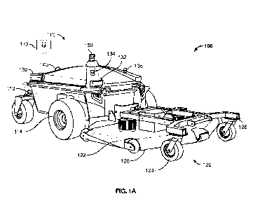
[0027] FIG. 1A is a perspective view of an AEM system including a mowing
vehicle and
mowing cutting deck in a deployed orientation in accordance with an embodiment
of the
invention;
[0028] FIG. 1B is a perspective view of another AEM system shown in a
lifted orientation
in accordance with an embodiment of the invention;
[0029] FIGS. 2A-2B are top views of lower and upper vehicle levels of the
mowing vehicle
with the cover removed in accordance with an embodiment of the invention;
[0030] FIGS. 3A-3B are partial top and rear views respectively of a mowing
vehicle with
the cover removed in accordance with an embodiment of the invention;
[0031] FIG. 4 is an enlarged view of the sealed outputs shown in FIG. 3B in
accordance
with an embodiment of the invention;
[0032] FIG. 5A is an exploded view of the cutting deck shown in FIG. 1A in
accordance
with an embodiment of the invention;
[0033] FIG. 5B is an exploded view of another cutting deck including an
actuator for
adjusting the height of the cutting plane in accordance with an embodiment of
the invention;
[0034] FIG. 6 is a flow diagram of an AEM method in accordance with an
embodiment of
the invention;
- 5 -
CA 03227432 2024-01-24
WO 2023/010045
PCT/US2022/074200
[0035] FIG. 7 is a power supply diagram of an AEM system in accordance with
an
embodiment of the invention;
[0036] FIG. 8A is a circuit diagram of an AEM system in accordance with an
embodiment
of the invention;
[0037] FIG. 8B is a circuit diagram of an AEM system in accordance with
another
embodiment of the invention;
[0038] FIG. 9A is a sensor interface diagram of an AEM system in accordance
with an
embodiment of the invention;
[0039] FIG. 9B is a sensor interface diagram of an AEM system in accordance
with another
embodiment of the invention;
[0040] FIGS. 10-12 illustrate various screen shots for a graphical user
interface in
accordance with an embodiment of the invention;
[0041] FIG. 13A is a block diagram of a software system of an AEM system in
accordance
with an embodiment of the invention;
[0042] FIG. 13B is a block diagram of another software system of an AEM
system in
accordance with an embodiment of the invention;
[0043] FIG. 14A is a block diagram of a perception software system of an
AEM system in
accordance with an embodiment of the invention;
[0044] FIG. 14B is a block diagram of another perception software system of
an AEM
system in accordance with an embodiment of the invention;
[0045] FIG. 15 is an illustration of an AEM system and sensor coverage in
accordance with
an embodiment of the invention;
[0046] FIG. 16 is a block diagram of a location software system of an AEM
system in
accordance with an embodiment of the invention;
[0047] Ha 17 is a flow diagram of a path planning software system of an AEM
system in
accordance with an embodiment of the invention;
[0048] HG. 18 is a block diagram of a state machine software system of an
AEM system
in accordance with an embodiment of the invention; and
[0049] FIG. 19 is a block diagram of a cloud-based system of an AEM system
in accordance
with an embodiment of the invention.
DETAILED DESCRIPTION OF THE INVENTION
[0050] Before the present invention is described in detail, it is to be
understood that this
invention is not limited to particular variations set forth herein as various
changes or
-o -
CA 03227432 2024-01-24
WO 2023/010045
PCT/US2022/074200
modifications may be made to the invention described and equivalents may be
substituted
without departing from the spirit and scope of the invention. As will be
apparent to those
of skill in the art upon reading this disclosure, each of the individual
embodiments described
and illustrated herein has discrete components and features which may be
readily separated
from or combined with the features of any of the other several embodiments
without
departing from the scope or spirit of the present invention. In addition, many
modifications
may be made to adapt a particular situation, material, composition of matter,
process,
process act(s) or step(s) to the objective(s), spirit or scope of the present
invention. All such
modifications are intended to be within the scope of the claims made herein.
[0051] Methods recited herein may be carried out in any order of the
recited events which
is logically possible, as well as the recited order of events. Furthermore,
where a range of
values is provided, it is understood that every intervening value, between the
upper and
lower limit of that range and any other stated or intervening value in that
stated range is
encompassed within the invention. Also, it is contemplated that any optional
feature of the
inventive variations described may be set forth and claimed independently, or
in
combination with any one or more of the features described herein.
[0052] All existing subject matter mentioned herein (e.g., publications,
patents, patent
applications and hardware) is incorporated by reference herein in its entirety
except insofar
as the subject matter may conflict with that of the present invention (in
which case what is
present herein shall prevail).
[0053] Reference to a singular item, includes the possibility that there
are plural of the same
items present. More specifically, as used herein and in the appended claims,
the singular
forms "a," "an," "said" and "the" include plural referents unless the context
clearly dictates
otherwise. It is further noted that the claims may be drafted to exclude any
optional element.
As such, this statement is intended to serve as an antecedent basis for use of
such exclusive
terminology as "solely," "only" and the like in connection with the recitation
of claim
elements, or use of a "negative" limitation. Last, it is to be appreciated
that unless defined
otherwise, all technical and scientific terms used herein have the same
meaning as
commonly understood by one of ordinary skill in the art to which this
invention belongs.
[0054] MOWER OVERVIEW
[0055] FIG. 1 A is an illustration of an AEM system 100 in accordance with
one
embodiment of the invention. The system 100 is shown having a vehicle 110 and
a cutting
deck 120 coupled to the front of the vehicle. In preferred embodiments, the
cutting deck
- 7 -
CA 03227432 2024-01-24
WO 2023/010045
PCT/US2022/074200
120 is detachably coupled to the vehicle by a hitch and a hitch electrical
connector,
discussed herein.
[0056] The vehicle 110 is shown having an enclosure 112; wheels 114
(preferably run flat
tires); cameras 130; E-stops 134, 136; GPS 140; LIDAR 150; and lights 132. Not
shown is
an inertial measurement unit (IMU). Enclosure 112 houses a number of hardware
and
software components (not shown) including but not limited to a chassis,
brakes, battery
cells, processors, motors, controllers, connectors, and communication
interfaces.
[0057] Cutting deck 120 is shown having anti-scalping mechanism 122, wheels
124,
steering rack 126, and cover 128 for housing the rotatable blades (not shown)
and discussed
further herein.
[0058] Preferably, the vehicle 110 and cutting deck 120 of the AEM system
are collectively
operable to autonomously mow an entire lawn area within a boundary while
detecting and
avoiding obstacles. However, as described herein, the vehicle 110 may also be
controlled
manually or by a command center 170, whether local or remote.
[0059] FIG. 1B is an illustration of an AEM system 100 in a lifted
configuration where
reference numerals in common with that shown in FIG. lA are meant to represent
the same
component and carry out the same function to the component described in FIG.
1A except
where the context indicates otherwise. The system 100 is shown having a 4-
wheeled vehicle
110 and a cutting deck 120 coupled to the front of the vehicle. The deck 120
has been lifted
to expose the blades 160 for maintenance, for example. In preferred
embodiments, the
cutting deck 120 is detachably coupled to the vehicle by a hitch and a hitch
electrical
connector, discussed herein.
[0060] FIGS. 2A-2B show lower level 210 and upper level 220 of a vehicle in
accordance
with an embodiment of the invention with the outer enclosure removed for
clarity.
[0061] With reference to FIG. 2A, lower level 210 is shown supporting 48
battery cells 212.
However, it is to be understood that the number of battery cells may vary
except as where
recited in any appended claims.
[0062] Charging port 214 is shown at the rear of the vehicle.
[0063] Electric motors 216, 218 are shown coupled to front wheels. Traction
controller 230
and battery management system (BMS) 240 are also mounted to lower-level frame.
[0064] With reference to FIG. 2B, upper level 220 shows computer 222,
cameras 224,
battery cells 226 and 24 V and 48 power distribution units (PDUs) 228, 230.
- 8 -
CA 03227432 2024-01-24
WO 2023/010045
PCT/US2022/074200
[0065] FIG. 3A shows a partial top view of lower level 210 of the vehicle
with the upper
level and enclosure removed. FIG. 3B shows a front view of the vehicle with
the enclosure
removed.
[0066] With reference to FIGS. 3A, 3B, traction motors 216, 218 are shown
supported by
chassis 252 and coupled to wheels. Traction motor controller 230 is mounted to
the chassis
on the upper level. Each side is shown having a dashboard 258 for sealed
outputs 262a, b,
c, d, e, f.
[0067] In embodiments, as discussed herein, the computer is operable and
programmed to
independently control the speed of each drive wheel, thus controlling the
vehicle ground
speed as well as steering.
[0068] HG. 4 is an enlarged view of the front left side of the vehicle
shown in FIG. 3B.
Dashboard 258 includes 6 outputs including left motor positive 260a, left
motor negative
260b, traction encoder 260c, traction brake 260d, deck power 260e, and deck
aux signals
260f.
[0069] CUTTING DECK DETAIL
[0070] HG. 5A shows an exploded view of a mowing cutting deck 300 in
accordance with
an embodiment of the invention. The mowing cutting deck 300 shown in FIG. 5A
includes
frame 310, castor wheels 320, anti-scalping mechanism 330, deck electronics
340, height
adjustment mechanism 344, hitch connector 350, blade container 360, blade
motor(s) 370,
automatic contour adjustment/roll joint 372, pivot joint 374 and cover 380.
[0071] As described herein, the deck electronics 340 are operable with the
electronics of
the mower vehicle 110 to control cutting. Examples of controlling cutting
include: start,
stop, and blade speed.
[0072] Additionally, a height adjustment mechanism 344 is operable to raise
and lower the
cover 380 relative to the frame 310 thereby adjusting the blades 360 to cut
the grass to a
desired (and tunable) height. The height adjustment shown in FIG. 5A is
manual, however,
the invention may also include an automatic height adjustment module including
an
actuator, and deck electronics to raise and lower the cover 380, described
herein.
[0073] With reference to FIG. 5B, a mowing deck including an automatic
height adjust
module is shown where reference numerals in common with that shown in FIG. 5A
are
meant to represent the same component and carry out the same function to the
component
described in FIG. 5A except where the context indicates otherwise.
Particularly, deck 300
is shown having actuator 345 for adjusting the height of the frame 310 instead
of the manual
arm 344 system shown in FIG. 5A. Sway bar 311 is a pivoting arm that provides
rigidity
- 9 -
CA 03227432 2024-01-24
WO 2023/010045
PCT/US2022/074200
in the horizontal plane to the blade cover 380. If the height adjustment is
automatic as in
the example shown in FIG. 5B, the mower can automatically make adjustments
based on
user preference or field conditions as detected by the mower. For example, a
golf-course
landscaping supervisor may desire to mow different parts of the course at
different heights.
The mower could store this information in its memory, and automatically cut
the grass at
the desired cut height as it enters each mow area, which greatly increases the
efficiency of
landscaping operations.
[0074] In embodiments, the mower automatically adjusts the deck height
based on
conditions and the planned route. For example, in embodiments, the mower
raises the deck
before the beginning of each turn, and lowers it after the end of each turn,
in order to
decrease the possibility of damage to the grass and reduce strain on the
mower's motors.
This automates a process that is manually performed by human operators in
certain
situations requiring particularly low grass cut heights.
[0075] In embodiments of the invention, the mower evaluates the height of
the grass for
cutting using the sensors or cameras. If the grass is too long to directly cut
to the desired
height, which may be harmful to the health of the grass, the mower
automatically mows the
grass to a higher cut height. The mower can return after a few days to mow the
grass again
to the ultimate desired cut height. Cutting the grass incrementally improves
the health of
the grass.
[0076] As shown, the mowing deck 300 preferably includes anti-scalping
wheels 330 which
are coupled to the cover 380 such that the blade assemblies 360 are prohibited
from scalping
the grass.
[0077] As discussed herein, a hitch or mount 374 serves to physically
detachably connect
the deck 300 to the main mowing unit or robotic vehicle 110 shown in FIGS. 1A-
1B. In
embodiments, the mechanical interface 374 to the mowing deck 300 comprises a
main
connection shaft 372 and a set of secondary connection points 350 connecting
to the main
shaft 372 for a secure mounting of the attachment while allowing the pitch
angle of the
attachment to be unrestrained. Circuit breaker 385 can cut power to the deck
when it is lifted
for maintenance.
[0078] Preferably, the deck is operable to conform to a wide range of
contours,
automatically adjusting the height of the multiple blade assemblies 360. In
the embodiment
shown in FIGS. 5A-5B, the deck includes a roll joint 372 and a pitch joint 350
so as to allow
the deck to be pushed or pulled (and in embodiments, steered) by the mower
along various
sloping terrains while maintaining each blade assembly predictably and
accurately spaced
- 10 -
CA 03227432 2024-01-24
WO 2023/010045
PCT/US2022/074200
at the desired height from the ground. Indeed, the joints 350, 372 allow for
the deck to tilt
forward and back as well as from side to side.
[0079] Not shown is an electronic connector to connect power and signals
and data transfer
between the deck and the mower. In embodiments, the electrical interface to
the mowing
deck consists of 3 connections, a high-power connection for the system's
actuation, a low-
level power connection for digital signal exchange, and a control area network
bus
(CANBUS) connection. In embodiments, the blade motor controllers relay blade
speed and
current draw information upstream, which is then used as a form of closed loop
control from
the high-level computer (e.g., computer 222) to (a) optimize and maintain the
blade speed
required to procure an optimal grass cut quality regardless of resistance and
(b) to detect
aberrant behavior and stop the blades as a factor of safety. For example, if
the blade speed
or power draw exceeds a threshold amount the computer commands the blade
motors to
halt.
[0080] METHOD FOR MOWING OVERVIEW
[0081] FIG. 6 is a flow chart illustrating an overview of a mowing method
400 in
accordance with an embodiment of the invention. As the steps of the method 400
are
described herein, reference may be made to one or more of the other figures
for illustrating
non-limiting exemplary hardware components or software modules for carrying
out the
steps of the method. However, the invention is not intended to be limited to
solely the
method set forth in FIG. 6, and any combination of the components, steps and
teachings set
forth herein are intended to be combinable except where such combinations are
exclusive
of one another.
[0082] With reference again to FIG. 6, step 410 states to turn on the AEM
system 100. In
embodiments, the system 100 includes a power on switch on the vehicle 110.
[0083] Step 420 states to determine the boundary of the mowing area. The
boundary of
the mowing area can be determined in various manners. For example, a candidate
boundary
may be loaded or selected from a database of predetermined or confirmed
boundaries based
on, e.g., the instant UPS location of the mower. The user can confirm the
candidate
boundary.
[0084] In embodiments, the boundary is created by tracing a perimeter of
the target mowing
area by driving the mower system along the perimeter using the manual control,
described
herein. The perimeter locations are detected by the onboard sensors and
cameras and the
boundary is stored.
-11 -
CA 03227432 2024-01-24
WO 2023/010045
PCT/US2022/074200
[0085] In another embodiment, the boundary is created by virtually tracing
the perimeter
of the target area on a display using an application on a PDA, smartphone,
tablet, computer,
or on-robot computer. For example, a software application can be operable to
provide a
satellite view (or another upper view-like illustration) of the robot's
surroundings and allow
the operator to designate (e.g., by drawing or marking) the desired boundary
or portion
thereof.
[0086] Still, in other embodiments, the boundary is created by driving the
mower along at
least a portion of the perimeter of the target area and a plurality of points
and their location
information are recorded. The computer fits a geometric shape (such as a
polygon) to the
recorded points that encloses the target mowing area. Optionally, as each new
point is
added, the boundary shape is updated until the user confirms the boundary is
acceptable.
[0087] In embodiments, the robot is operable to perform (optionally,
automatically) a
second or boundary refining step. The computer refines the boundary of the mow
area as
initially drawn (e.g., drawn on the display) by the user into a more precise
boundary using
its perception sensors and artificial intelligence. For example, the boundary
points input by
the user using a satellite view has limited resolution and accuracy. The robot
can
automatically identify the edges of a mowable lawn using its cameras and
sensors, and
follows these edges near the approximate boundary provided for the user. This
works for
both external boundaries, such as the boundary between a lawn and a flowerbed,
and
internal boundaries, such as paved walkways, trees, or other obstacles in the
middle of a
lawn. Thus, in embodiments, the initial high-level user input to create a
first boundary is
turned into a reliable, more precise mowing boundary, greatly increasing the
efficiency of
the overall mowing and landscaping process.
[0088] Not shown, in embodiments, the robot computer is programmed to
automatically
compute or suggest mowing patterns for the target area including number of
turns, angle,
obstacles to avoid (e.g., patio or pond), etc. The boundary and pattern can be
presented to
the user for confirmation or adjustments.
[0089] Step 430 states to instruct the AEM system 100 to commence mowing.
Examples
of embodiments to perform step 430 include to instruct the mower to begin
mowing via a
controller (via wired or wireless), a web application, or an on-board device
(e.g., a
touchscreen).
[0090] Step 440 states to perform mowing. The AEM system 100 automatically
performs
mowing safely, accurately, and efficiently to complete mowing of the entire
area as defined
by the boundary, determined above. In preferred embodiments, the mowing step
is
- 12 -
CA 03227432 2024-01-24
WO 2023/010045
PCT/US2022/074200
performed according to the planned route computed above as well as executing
an obstacle
recognition and avoidance plan, described further herein.
[0091] Step 450 states mowing is complete. The AEM system detects when
mowing is
complete and communicates to the operator that mowing is complete. Examples of
communication include audio forms such as honking a horn on the vehicle 100 or
sending
a notification to any open web application, such as an application on the
operator's
smartphone, tablet or computer. The computer (with optional touch screen) can
also be
located on the robot.
[0092] Optionally, the operator can direct the AEM system to a new mowing
area and
commence mowing in another area.
[0093] Additionally, in embodiments, the mower is set to mow multiple areas
one after the
other, and to automatically drive between them. The operator can thus setup
the robot to
fully autonomously mow multiple mowing areas within a single geographical
area. By
operating fully autonomously during this entire process, which can span hours
of time and
acres of mowing, the robot greatly increases the efficiency of mowing
operations.
[0094] Step 460 states to power off the AEM system. As described above,
this step may
be performed, for example, by a power switch on the vehicle itself, or an App
on the
smartphone, tablet or computer.
[0095] BLOCK DIAGRAMS
[0096] FIG. 7 is a power supply diagram of an AEM system 500 in accordance
with an
embodiment of the invention. A first or high-power system 510 is shown
isolated from the
second or lower voltage system 550, both supported by floating chassis 502.
[0097] The high-power system is preferably 48 V, and includes a 48 V PDU
514 which
delivers the current to deck controllers and motors 520 and the traction
controller and
motors 530.
[0098] The lower power system 550 is preferably 24 V and operable to supply
power to the
computer, sensors, and wireless estop (collectively 580). discussed herein,
via 24 V PDU
570.
[0099] An external charger (DC charger) is shown to charge the battery
pack. Preferably,
the charger is adapted to be connected to a standard outlet (e.g., 120 or 240
V).
[00100] FIG. 8A is a circuit diagram of an AEM system 600 in accordance with
an
embodiment of the invention. Four circuits are shown in FIG. 8A including 48V
610, 24V
620, signal 630, and estop 640.
- 13 -
CA 03227432 2024-01-24
WO 2023/010045
PCT/US2022/074200
[00101] FIG. 8B is a circuit diagram of another AEM system 650 in accordance
with another
embodiment of the invention. Five circuits are shown in FIG. 8B including 48V
(652), 24V
(654), signal (656), CANBUS (658), and estop (660).
[00102] Three different types of deck circuits 680a, 680b, and 680c are shown
in FIG. 8B
including a high-power cutting deck with a manually-operated lift, a deck 680b
with a first
type of electric linear actuator 682, and a deck 680c with a second type of
linear actuator
684 including a dedicated power source and controller.
[00103] Each deck circuit 680a, 680b, and 680c is shown with a deck connector
670a, 670b,
and 670c respectively which can be detachably coupled to the main robotic unit
668 as
described herein.
[00104] The main robotic unit 668 is shown organized according to a
shell/enclosure 662,
top plate 664, and chassis 666.
[00105] FIG. 9A is a sensor interface diagram of an AEM system 700 in
accordance with an
embodiment of the invention. A computer or processor 710 such as, e.g., a NUC
computer
manufactured by OnLogic Inc. (South Burlington, Vermont) is shown operable to
receive
sensor data from LIDAR 720 via ethernet. An exemplary Lidar sensor 721 is the
0S1,
manufactured by Ouster Inc. (San Francisco, California). The data is shown
being
communicated via modem 722 such as, for example, one of the models available
from
Cradlepoint, Inc. (Boise, Idaho), however, the data may alternatively be
transferred to
computer 710 via wireless technology.
[00106] FIG. 9A also shows a sensor module 730 including a plurality of
cameras (e.g.,
visible spectrum cameras), inertial measurement unit (IMU), and GPS sensor.
The sensor
module is shown in communication with the computer 710 via USB connection.
[00107] The number and types of sensors may vary widely. Examples of sensors
include,
without limitation, visible spectrum cameras (e.g., a black and white, or RGB
camera),
depth sensors, ultrasound, GPS, odometry, IMU motion, radar, and infrared (IR)
or multi-
spectrum cameras.
[00108] In embodiments, a sensor module 730 includes multiple visible spectrum
cameras.
In a preferred embodiment, the system includes 6 visible spectrum cameras
symmetrically
distributed about the vehicle and arranged such that the focal length of the
camera lens and
orientation of the optics capture an image of 360 degrees from the vehicle. An
exemplary
visible spectrum sensor is the Intel RealSense Depth Camera D455,
manufactured by Intel
Corporation (Santa Clara, California).
- 14 -
CA 03227432 2024-01-24
WO 2023/010045
PCT/US2022/074200
[00109] In embodiments, different sensing modalities are combined into an
integrated sensor
including its own dedicated electronics. For example, the visible spectrum
cameras can be
paired with infrared spectrum depth-sensing cameras or time of flight cameras,
as
exemplified by the aforementioned Intel RealSense cameras, such that the
cameras
collectively capture and provide to the robot a three-dimensional view of the
area 360
degrees around the robot.
[00110] With reference to FIG. 15, an example of the camera and sensor
coverage is shown
in accordance with an embodiment of the invention where stippled areas are
indicative of
the visible light spectrum cameras and the expanding concentric circles
represent the
radiating 360 LIDAR. Collectively, the sensors and cameras achieve 360-degree
coverage
including redundant or areas of overlap (e.g., 01, 02, 03, 04) in which the
computer can
select the most relevant data.
[00111] The Inertial Measurement Unit (IMU) provides the robot with
orientation (roll,
pitch, yaw), including the robot's heading with respect to magnetic north as
well as true
north, as well as linear and angular accelerations. An exemplary IMU sensor is
the Xsens
Technologies MTI-30-2A804, manufactured by Xsens Technologies BY (Enschede,
Netherlands).
[00112] The Global Positioning System (GPS) sensor estimates the robot's
latitude,
longitude, and altitude. An exemplary GPS sensor is the Emlid Reach M+,
manufactured
by Emlid Ltd (Hong Kong).
[00113] FIG. 9A also shows the computer 710 in communication with traction
motor
controller 740 for controlling the traction motor, and a first control area
network (CAN1)
750 for communicating with the deck controllers. The traction motor controller
receives
drive speed targets from the computer over network 750 and provides the
necessary
electrical power to the two brushed DC motors (optionally brushless) driving
the vehicle to
achieve these speed targets using a built-in PID controller and feedback from
encoders
mounted on the motor shafts. An example of a traction motor controller is the
GDC 3660
from Roboteq (USA).
[00114] In embodiments, steering is accomplished in a nonhonomic manner by
sending
independent wheel velocity commands to each individual traction controller on
the left and
right of the vehicle/robot in the form of a differential drive system.
[00115] The blade or deck motor controllers receive blade speed targets from
the computer
over network 750 and provide the necessary electrical power to the 3 motors
driving cutting
blades to achieve these speed targets using a built-in PID controller and
feedback from hall
- 15 -
CA 03227432 2024-01-24
WO 2023/010045
PCT/US2022/074200
effect sensors inside the motors. An example of a deck motor controller is the
1226BL from
Curtis Instruments (USA).
[00116] A second control area network (CAN2) 760 is shown for managing
charging.
Preferably, a separate CANBUS network is dedicated to managing the charge rate
with the
charger. Prior to charging, the BMS sends messages to the charger to describe
the allowable
charge rate and amperage. If the charger CANBUS is disconnected, the charging
will cease
to protect the batteries. Physically, there is a separate CANBUS because the
physical layer
of CANBUS has terminating resistors at both ends of the bus and the charger
end may be a
considerable distance from the BMS.
[00117] FIG. 9B is a sensor interface diagram of another AEM system 800 in
accordance
with an embodiment of the invention where the components in common with that
shown in
FIG. 9A are meant to be the same type of component and carry out the same
function to the
component described in FIG. 9A except where the context indicates otherwise.
[00118] Amongst other differences shown in the diagram in FIG. 9B from that
shown in
FIG. 9A is the dedicated wireless controller 810 to drive the robotic vehicle
unit. An
example of a suitable wireless controller is the Taranis X9 Lite S by FrSKY
Electronics
Co., Ltd (Wuxi, 214125, Jiangsu, China).
[00119] SOFTWARE FLOW DIAGRAM
[00120] With reference to FIG. 13A, a high-level software block diagram of an
AEM system
1300 is shown in accordance with an embodiment of the invention. AEM system
1300 is
shown comprising a robot, namely mower 1302 and a plurality of software
modules 1304.
The software can be stored on a local storage device and include several
modules, each of
which is discussed in more detail herein. The software modules shown in FIG.
13A include:
perception module 1310 for detecting obstacles along the path, localization
module 1320
for determining location of the AEM, map loader 1330 for loading maps of the
candidate
area to mow, path planning module 1340 for determining the route of the AEM,
state
machine 1350 for managing the states of the AEM, safety module 1352 for
preventing
injuries during operation, and Web Apps 1360, 1370 to provide visibility and
control to
remote users via computing devices connected to the internet. Examples of
computing
devices include, but are not limited to, smartphones, tablets, notebooks,
desktops and
workstations.
[00121] FIG. 13A also shows exemplary hardware components on the robot 1302
for
operating with software modules in accordance with embodiments of the
invention.
Particularly, and discussed further herein, the robot 1302 is shown having a
wide range of
- 16 -
CA 03227432 2024-01-24
WO 2023/010045
PCT/US2022/074200
sensors 1390, wheel motors 1392, deck motors 1394, horn 1306, wired emergency
stop
1308, onboard touchscreen 1312, handheld controller 1396 (e.g., a wired or
wireless
controller for driving the vehicle as described above), and remote emergency
stop 1398.
[00122] FIG. 13B shows a high-level software block diagram of an AEM system
900 in
accordance with another embodiment of the invention. AEM system 900 is shown
comprising a plurality of software modules and hardware. The software can be
stored on a
local storage device and include several modules, each of which is discussed
in more detail
herein. The software modules shown in FIG. 13B include: perception module 910
for
detecting obstacles along the vehicle path, localization module 920 for
determining location
of the vehicle, map loader 930 for loading maps of the candidate area, path
planning module
940 for determining the route of the vehicle, state machine 950 for managing
the states of
the system, safety module 952 for preventing injuries during operation, driver
module 960,
and external controls 970. The external controls 970 provide visibility and
control to remote
users via, e.g., a joystick. In embodiments, as discussed herein, the onboard
computer may
be accessed by an onboard touchscreen display or via a remote or portable
computing
device. The AEM system 900 preferably includes a wireless communication module
to
communicate with such computing devices. Examples of computing devices
include, but
are not limited to, smartphones, tablets, notebooks, desktops and
workstations.
[00123] PERCEPTION MODULE
[00124] FIG. 14A is a more detailed block diagram of a perception software
module 1400
of an AEM system in accordance with an embodiment of the invention. As
described above,
the perception module 1400 is intended to detect obstacles as the mower is
operating.
[00125] The module 1400 shown in FIG. 14A receives data from multiple cameras
1410
(typically, color and depth cameras) and LIDAR 1420 for capturing image data
of the
surroundings. The image data from each sensor type can be fed in the form of a
3D
pointcloud into detectors 1430, 1432, 1434 for detecting whether an obstacle
is present.
The detector(s) 1430, 1432, 1434 may be neural network-based.
[00126] Descriptions of examples of neural network approaches for detection
include, for
example, Ross, Girshick (2014), "Rich feature hierarchies for accurate object
detection and
semantic segmentation", Proceedings of the IEEE Conference on Computer Vision
and
Pattern Recognition. IEEE. pp. 580-587; Girschick, Ross (2015), "Fast R-CNN",
Proceedings of the IEEE International Conference on Computer Vision, pp. 1440-
1448;
and Shaoqing, Ren (2015). "Faster R-CNN", Advances in Neural Information
Processing
Systems, arXiv:1506.01497.
- 17 -
CA 03227432 2024-01-24
WO 2023/010045
PCT/US2022/074200
[00127] FIG. 14A also shows object classifier 1440 for classifying the object
detected from
the detectors 1430, 1432, 1434. The object classifier is trained to recognize
humans,
vehicles, animals, etc. The classifier 1440 may be neural network-based.
[00128] Descriptions of examples of object classifiers include, for example, a
trained
convolutional neural network.
[00129] In embodiments, a convolutional neural network is trained. First,
candidate
obstacles are placed in the sensor field of view and image input data is
generated and
collected. In embodiments, the CNN is trained by positioning on a lawn one or
more of the
following objects: humans, trees, ponds, sand pits, and animals.
[00130] Next, the image data is labeled. Particularly, the image data is
presented to a human
user who identifies relevant objects in the image (classifies) and creates
bounding boxes for
the images (locates). The data from the human user is then recorded into the
form of the
output layer that the CNN should create when presented with the input image
data.
[00131] Next, the input images and output layer are divided into training,
validation and test
sets. The training data set is presented to the model and periodically
compared with the
validation data set. The parameters of the CNN are adjusted based on the
results of the
validation set. The process is repeated multiple times (multi-stage). With
each iteration,
the weighting factors of the CNN can be modified. Examples of weighting
factors adjusted
to tune the model include, without limitation, the weights of the connections
between each
neuron in one layer of the CNN and each neuron in the next layer of the CNN.
[00132] Although a machine learning dataset creator is described above, the
invention is not
intended to be so limited except where recited in any appended claims. Indeed,
a wide
variety of trained models may be utilized or part of the subject invention.
[00133] FIG. 14A also shows data fusion module 1460 which receives inputs from
obstacle
detectors 1430, 1432, 1434, obstacle classifier 1400, and optionally, robot
localization
module 1450. In embodiments of the invention, the localization module 1450,
discussed
herein, is operable to provide global positioning location information of the
robot mower to
the fusion module.
[00134] Fusion module 1460 combines the obstacle detection data from each of
the sensors
(e.g., probabilities that an object is present), the classification data
(e.g., probability the
object is a human or another specific type of obstacle), the localization data
(e.g., global
position of the robot), and the time or clock and computes the obstacle
location and type
1470. By having multiple redundant sensors as described, the safety and
reliability of the
obstacle detection system is increased, such that a failure of any one sensor
(or even several
- 18 -
CA 03227432 2024-01-24
WO 2023/010045
PCT/US2022/074200
sensors) does not compromise the safety of the overall system. As discussed
herein, the
output from the perception module is used to decide how to handle the
particular obstacle,
for example by stopping and alerting a human or by autonomously avoiding
obstacles along
the path of the mower. Additionally, in embodiments, the invention can include
redundant
computing of obstacles, classification, localization, and logic or decision
rules such as
optimized navigation behaviors, namely, speed regulation and path selection
when
approaching a living object versus a non-living object, for enhancing safety,
and serving to
provide fail safe operations.
[00135] With reference to FIG. 14B, another module 1500 for obstacle detection
is shown
in accordance with embodiments of the invention. The module shown in FIG. 14B
utilizes
a combination of camera sensors such as the LIDAR 1510 and the RGBD camera
units 1520
to obtain a 3D pointcloud 1512, RGB Image 1514 and depth cloud 1516,
respectively.
[00136] With reference to LIDAR data track, the ground surface is segmented
from the 3D
point cloud 1520.
[00137] Then, a filtered obstacle cloud 1530 is generated by probabilistically
removing
outliers for effective obstacle detection.
[00138] With reference to the RGBD camera track, a classifier 1534 as
described above
classifies the objects from the ROB image.
[00139] The depth data is applied to the object to generate an object depth
estimation 1536.
[00140] The processed data from the RGBD and LIDAR cameras is calibrated to a
single
coordinate system and fused 1540.
[00141] In preferred embodiments, the data from each of the RGBD and LIDAR
sensor units
is evaluated and weighted for determining the presence of an obstacle 1550.
Examples of
logic rules include: (a) to determine which modality source to employ based on
environmental conditions (e.g., night versus day), (b) to determine whether
the object is
living or nonliving, and to plan a subroute to avoid the obstacle accordingly,
(c) to determine
whether one sensor or type of sensor data is sufficient (e.g., dense enough)
to capture
smaller resolution obstacles, (d) to determine which combination of one or
more sensors
generate a sufficient field of view to avoid blind spots, and (e) to determine
and bound a
region of interest (e.g., an obstacle) as detected by the cameras and to
determine an optimum
distance from the region of interest based on the LIDAR data.
[00142] The obstacle type and location are then sent to state machine 1560.
[00143] FIG. 15 is an illustration of sensor/camera coverage in accordance
with an
embodiment of the invention. It depicts 360-degree scanning from the vehicle
2110. In
- 19 -
CA 03227432 2024-01-24
WO 2023/010045
PCT/US2022/074200
particular, it shows the visible spectrum and depth sensing cameras (2130,
2140, 2150,
2154, 2160, 2164) and the LIDAR 2170, and the fields of view (2132, 2142,
2152, 2156,
2162, 2166, 2172, 2174, etc.) including regions of overlap (01, 02, 03, 04).
The robot has
360-degree perception data from the multiple sensors. If any one particular
sensor were to
be obstructed or otherwise fail, the robot would be able to detect the sensor
failure by
comparing its output to another sensor. The robot can then replace the data
from the area
covered by the suspect or offending sensor with that from an unobstructed or
valid sensor.
[00144] The mower can also monitor the health of the grass using data from its
cameras,
LIDAR, feedback from the cutting deck motors, or other sensors. By including
such sensors
on an autonomous mobile platform (the mower) and reporting it for each
location the mower
covers, the system provides a far higher granularity of data than that
possible from sensors
installed in fixed locations. This data can be presented to the user in a
cloud network for
detailed visualization and analysis. These metrics help owners and operators
identify
adjustments that may need to be made, such as irrigation, seeding, aeration,
or chemical
sprays, increasing the health of their lawns and efficiency of their
operations.
[00145] LOCALIZATION MODULE
[00146] FIG. 16 is a block diagram of a localization module 1600 of an AEM
system in
accordance with an embodiment of the invention. As described herein, the
localization
module 1600 predicts local and global estimates for the robot mower.
[00147] The sensor inputs 1610 shown in FIG. 16 include: GPS, IMU, LIDAR, and
wheel
encoders.
[00148] An example of a suitable GPS sensor is the Reach M+, manufactured by
Emlid Inc.
(Hong Kong). The GPS generates latitude and longitude coordinates, which are
converted
to X and Y global coordinates. Examples of outputs from the GPS sensor
include: GPS
handler, localization safety, Baser and NTRIP. In embodiments, the GPS handler
is
operable to check GPS data and produce orientation information and magnetic
declination
corrections to the GPS data. The Localization Safety can gauge the health of
position state
estimates from each modality and determine threshold for failure. The
Localization Safety
can also suggest recovery or ask the robot to stop. Baser and NTRIP optionally
can be
combined into one node that provides intemet-based latitude and longitude
corrections to
the singular GPS receiver on the robot.
[00149] An example of a suitable IMU sensor is the MTI-30-AHRS by Xsens Inc.
(Enschede, Netherlands). The IMU generates values for roll, pitch, yaw, yaw
rate, and
linear as well as angular acceleration.
- 20 -
CA 03227432 2024-01-24
WO 2023/010045
PCT/US2022/074200
[00150] An example of a suitable LIDAR sensor is the OS1, manufactured by
OUSTER
(USA). The LIDAR generates 3D image data.
[00151] An example of a motor with a suitable wheel encoder is ASI Drives
Thunder 1500
manufactured by ASI Drives (Montgomeryville, PA). The wheel encoder generates
speed
data for the vehicle.
[00152] The robot mower state 1620 indicates the current state of the robot
mower based on
the data generated by the sensor inputs.
[00153] Next, a state estimate is computed. In embodiments, a filter 1605 is
applied (e.g., a
Kalman type of filter may be applied) for both local and global state
prediction. A Kalman
filter is an algorithm for improving signal tracking. A Kalman filter
generally includes a
physical model of an object and uses the physical model to predict the next
measurement
(e.g., to where did the object move). Examples of types of Kalman filters that
can be used
in embodiments of the invention include, without limitation, the Extended
Kalman Filter,
or other versions of the Kalman Filter.
[00154] In embodiments, a global state estimate is computed using a plurality
of sensors
namely the UPS, IMU, Wheel Encoders, cameras and LIDAR. In embodiments of the
invention, the LIDAR and the CAMERA use features from the environment to gauge
the
motion of the robot with an initialization base factor formulated from the
Wheel Encoders,
IMU and GPS. Both the LIDAR and the CAMERA position estimates are assigned a
cost
according to how reliable their internal noise parameters are, and how
plausible the end data
is with respect to the environment. This information pools into a gaussian
state estimation
and smoothing algorithm that runs an optimizing function to determine the best
possible
state estimate at any given point of time. In the event data from any of the
modalities is
deemed not sufficient or untrustworthy, that information is disregarded and
another
modality is used as a reliable source. Examples of scenarios where data is
deemed
unreliable or untrustworthy is where environmental conditions are too dark,
too bright, the
speed of rotation is too high or there is significant occlusion for the RGBD
camera to
procure reliable landmark information to generate a healthy position state
estimate. In the
latter event where there is a significant occlusion in the RGBD field of view,
in
embodiments, the location algorithm is operable to select the position state
estimate
procured from the Lidar which tends to be more tolerant to this type of RGBD
failure.
Preferably, each modality is weighted and the highest weighted modality
provides a bias to
correct the data streaming from the lower reliable modalities during
operation. This is done
- 21 -
CA 03227432 2024-01-24
WO 2023/010045
PCT/US2022/074200
by first formulating the data from each modality as a non-linear problem and
then running
optimizing functions to minimize the error and generating a health score.
[00155] FIG. 16 shows computing the final position 1660 based on the local and
global
Kalman Filters. Local and global values can be computed for position (e.g., X,
Y, Z),
orientation, pose certainty, speed certainty. Additionally, an evaluation of
the estimated data
quality can be output (e.g., is the data continuous-no abrupt jumps in
localization estimate).
[00156] PATH PLANNING
[00157] FIG. 17 is a flow diagram of a path planning software method 1700 of
an AEM
system in accordance with an embodiment of the invention.
[00158] Step 1710 states selecting the mowing area. This step may be performed
by, for
example, (a) manually using a controller to guide the mower along the boundary
of the
mowing area, (b) drawing/denoting the boundary over a satellite or top view of
the target
area on a display in an App, or (c) selecting a boundary from a database of
previously-
determined or known boundaries.
[00159] In a preferred embodiment, boundary mapping is performed as follows:
(a) the user
activates a boundary generation module, (b) the user drives the vehicle (via
joystick for
example) along a perimeter of the target area, (c) the computer system records
points during
the drive, and (d) the computer calculates a multi-sided polygon to encompass
the points.
In a preferred embodiment, the computer system records the vertices of a
boundary polygon
utilizing location information by Gaussian-based localization described
herein.
[00160] Optionally, the computer can be programmed to automatically compute
the
geometric boundary shape as each point is recorded. Then the user confirms the
boundary
when the boundary is deemed acceptable to the user. For example, the user may
continue
to generate or record more points until the boundary appears relatively smooth
and does not
cut off regions of the target area. To this end, it is to be understood that
the number of
recorded points may vary in order to generate the boundary. In embodiments,
the number
of recorded points is at least 3, and typically between 4-100,000, and in
embodiments,
between 10-1000 points.
[00161] It is also to be understood that in embodiments of the invention, the
driving need not
form a closed shape such as a circle or polygon, the above-described algorithm
computes a
closed shape polygon based on the recorded points whether the points form an
enclosed
boundary or not.
[00162] In an alternative embodiment, instead of driving the mower, the user
traces/draws
the boundary or portions of the boundary via various user interfaces such as
an onboard
- 22 -
CA 03227432 2024-01-24
WO 2023/010045
PCT/US2022/074200
touch screen or portable computing device. The computer is operable to carry
out the
remainder of the steps described above in order to enclose the recorded
points, and finalize
the boundary.
[00163] Step 1720 states mowing module which is operable to compute a global
path 1730
including a particular mowing pattern within the boundary (e.g., to plan rows
for the entire
area). This step may be performed on a computer and based on the selected
mowing area,
desired completion time, the desired overlap between successive rows (e.g.,
between 10-50
cm), desired pattern (e.g., mow alternating rows to minimize impact on grass),
the type of
turn desired at the end of each row (e.g., U-turn, or Y-turn), the desired
direction of the
rows, and potentially other inputs. This step ensures the robot will cover the
entirety of the
mowing area when mowing.
[00164] In embodiments, and after the target boundary has been computed, a
coverage
planner algorithm determines optimal coverage pattern within the boundary. In
embodiments, the optimal coverage pattern is based on reducing the number of
turns,
reducing mow time, and/or increasing efficiency from a power consumption
standpoint. In
embodiments, the user may input to the path planner various options such as
grass height
or mowing directions. Examples of mowing directions can include patterns such
as hatched,
cross, concentric circular, concentric rectangular, or solid or any
combination of the
patterns. Additionally, a target area may be divided into multiple subareas,
each of which
has a unique route and mowing characteristics. For example, the golf putting
green
desirably has a short height, and is row-free. In contrast, the rough may be
cut long, and
have one or more row patterns. Customizing mowing as described herein (whether
based
on user input or automatically computing to optimize mowing efficiency or
another goal)
serves to maintain any aesthetic requirement that may be desired for a
particular lawn
whether golf, soccer, school ground, park, etc.
[00165] Step 1740 states to query for obstacles in the path of the mower.
Obstacles are
detected by sensors and a perception module as described herein. If obstacles
are detected,
the robot can be set to stop for the obstacles, or to avoid them. If avoiding
obstacles, the
local planner 1750 calculates a buffer or padding form the obstacle, and
detour to avoid the
obstacle and return to the global path 1730. In embodiments, the local planner
1750 is a
software module that computes a short path around the obstacle and back to the
original
mowing row by evaluating many possible paths around the obstacle and choosing
one that
maximizes metrics such as proximity to the original row path, proximity to the
goal
(returning to the row beyond the obstacle) and avoids getting close to
obstacles. In
-23 -
CA 03227432 2024-01-24
WO 2023/010045
PCT/US2022/074200
embodiments, obstacles are populated from multiple modalities on a two-
dimensional map
grid representation in the form of weighted occupancy with added padding as a
safety layer.
The obstacles are automatically marked and cleared off of the map grid
according to the
perspective of each sensor modality. The path for the robot is also defined on
the same map
grid where the footprint of the robot is checked against obstacle occupancy to
determine a
safe stoppage recovery mechanism and a replanning solution. Obstacle marking
on this map
grid may be annotated and labeled differently for representation and
classification of
multiple types of obstacles (e.g., living or non-living) so as to have the
path planner choose
replanning routes in accordance with safety. In embodiments, the detour would
comprise a
greater distance from a living obstacle than a non-living obstacle.
[00166] If obstacles are not detected 1760, the path tracker continues
tracking along the
global path.
[00167] As the mower follows the global path, step 1770 queries whether the
path is
completed. If the path is not completed, the mower continues along the path
and
continuously checks for obstacles. If the path is completed 1770, the mowing
is halted and
the robot mower is stopped 1780.
[00168] In preferred embodiments the mower is steered by independently
adjusting the
rotation speed of the driving wheels 114, a method commonly known as
differential
steering. In such embodiments the non-driving wheels of the robot are mounted
on
swiveling casters.
[00169] STATE MACHINE
[00170] HG. 18 is a block diagram of a state machine 1800 of an AEM system in
accordance
with an embodiment of the invention. The state machine module 1800 is operable
to receive
information and data from the various modules as described and shown in, e.g.,
FIGS. 13A,
13B and to update and store the status of the system. Several states are shown
in FIG. 18
including: health check 1810, standby 1820, cut mode 1830, cut debug mode
1840,
shutdown 1850, remote control 1860, maintenance 1870, admin 1872, and record
1874.
[00171] After the system is turned on (1802), a health check is performed
1810. Particularly,
the health check verifies that important components of the system are
functioning properly.
This includes, but is not necessarily limited to, the blade deck, GPS
receivers, LIDAR,
battery management system, and the wheel motor controllers. If the health
check does not
pass, the system state is failed 1804. If the health check passes, the system
state is standby
1820.
- 24 -
CA 03227432 2024-01-24
WO 2023/010045
PCT/US2022/074200
[00172] From the standby state, a human operator can transition the robot to
other states as
desired. To operate the robot using a remote control, for example, the
operator sets the
robot to Remote Control mode 1860. When ready for autonomous mowing, the
operator
sets the robot to Cut Mode 1830. The operator can cycle between these modes an
arbitrary
number of times, and thus mow a large property consisting of multiple mowing
areas.
[00173] CLOUD NETWORK
[00174] FIG. 19 is a block diagram of a cloud-based system 1900 of an AEM
system in
accordance with an embodiment of the invention. One or more robot mowers 1910
are
shown in communication with local computing devices 1922 for operators 1920.
Examples
of computing devices include, without limitation, smartphones, tablets, and
computer
workstations. The operators may command the robot mower via the local
computing
devices. In embodiments, a local dedicated command center includes a computing
device
to control and monitor the AEM system(s).
[00175] Both the robot mowers 1910 and local computing devices 1922 are also
operable or
programmed to communicate with a remote server (e.g., remote cloud-based
server) 1930
via a public network, and more preferably a virtual private network (VPN)
1940. Each of
the robot mowers and computing devices can include wireless communication
modules or
interfaces to send and receive data with one another. Examples of suitable
wireless
communication technologies are Cellular, Bluetooth, and Wi-Fi.
[00176] Cloud services 1930 can include: remote terminal and user interface,
alert systems,
operating system and software updates, and data analytics and visualization,
machine
learning model updates (e.g., for the localization, obstacle detection, and
obstacle
classification models described herein), and machine learning dataset creator.
In
embodiments, cloud services can include a command center to review and control
the robot
mowers.
[00177] The machine learning dataset creator semi-automatically creates a
dataset to
improve the performance of machine learning models deployed on the robot. For
example,
if one wants to improve the robot fleet's performance in identifying dogs, one
could provide
a model trained to identify dogs that has some baseline performance with a
relatively high
false positive rate. This model can be deployed on the robot fleet and used to
automatically
get many images of dogs as well as objects that the robots falsely classify as
dogs. In such
a manner a large dataset can be created, and after labeling and retraining the
model which
images contain the real dogs, an improved machine learning model to identify
dogs is
created.
- 25 -
CA 03227432 2024-01-24
WO 2023/010045
PCT/US2022/074200
[00178] GRAPHICAL USER INTERFACE
[00179] FIGS. 10-12 illustrate various screen shots for a graphical user
interface (GUI) in
accordance with an embodiment of the invention.
[00180] With reference to FIG. 11, the GUI 2010 shows candidate maps to load
for mowing.
The operator may select a map to load for path planning as described above. In
embodiments, an App is programmed to automatically generate one or more
candidate maps
based on the detected location of the operator.
[00181] With reference to FIG. 10, the GUI 2020 shows an enlarged view of the
selected
map including a tab for selecting a mowing angle. As described above, the
instructions are
communicated to the robot mower to be performed by the mower.
[00182] The GUI 2020 also shows a tab for mode 2026. The operator may
select, e.g., a
manual or autonomous mode as described above.
[00183] The GUI 2020 also shows a tab for status 2028 including battery life
and mowing
time.
[00184] The GUI 2020 also shows a tab for stop 2029. The operator can stop the
vehicle at
any time as described above.
[00185] With reference to FIG. 12, the GUI 2030 shows a tab for various
metrics such as
power and performance 2032. Other information can include battery life and
estimated time
for completion.
[00186] The GUI 2030 also shows a tab for localization 2034 to report GPS
information. In
embodiments of the invention, one GPS unit performs internet-based corrections
to position
estimates in latitude and longitude (e.g., NTRIP). However, other embodiments
of the
invention may incorporate or utilize other GPS configurations including, for
example, a
local (non-internet) base station to perform position estimates in latitude
and longitude (e.g.,
baser).
[00187] The GUI 2030 also shows a tab for obstacle detection 2036 to indicate
the detection
of an object, as described above.
[00188] ALTERNATIVE EMBODIMENTS
[00189] Although various embodiments have been described above, it is to be
understood
the invention may vary and include additional or less components and steps
than that
described above. For example, in another embodiment, the vehicle is operable
independent
from a particular type of attachment (e.g., the mowing deck). The main
autonomous vehicle
can include a drive means (e.g., one or more drive wheels), brake and brake
controller, a
plurality of sensors that are utilized for localization, navigation and
perception, and a
- 26 -
CA 03227432 2024-01-24
WO 2023/010045
PCT/US2022/074200
universal port/interface for power supply, data/communication bus and
mechanical docking
support between the vehicle and the slave attachment. This enables the vehicle
to support
a wide variety of attachments.
[00190] On-board electronics can be programmed or operable to automatically
detect the
type of attachment, and to dynamically configure the system state in
accordance with the
detected slave attachment such that the robot can autonomously fulfill other
functions of
value in the landscaping or other industries, including but not limited to
grass or brush
mowing with a reel mower, reciprocating dual blade trimmer, or rotating weed
Wacker
using a flexible disposable string. Other applications and attachments that
may be
incorporated into the system include, without limitation: aerating deck
including a rotating
or actuatable divot or hole puncher; irrigation deck including a water tank
and a flow-
controlled nozzle, and optionally a water pump; fertilizing deck including a
hopper and
controllable release valve to control flowrate of fertilizer dispensed,
chemical spraying deck
including a tank and flow controlled-valve, golf ball collection assembly
including a
mechanical and/or suction action to pick up golf balls and store in
receptacle; and a security
deck for providing surveillance and security cameras, sirens, or lights not
present on the
main unit. The main unit computer is operable to recognize each deck or
attachment, and
to operate according to the application protocol or module. As described
above, the
computer and electronics may have application modules stored locally on the
main unit
computer, may be received from the accessory deck or attachment via the
umbilical cable,
or may be downloaded from the cloud services through a VPN or public network.
[00191] Still, in other embodiments, the system is attachment-free, and
operates
autonomously for a wide variety of applications such as, for example, security
and detection
of objects, inspection of object (e.g., inspection of solar panels, grass cut
or pattern or
completeness, or irrigation systems), etc.
[00192] Still other modifications and variations can be made to the disclosed
embodiments
without departing from the subject invention.
-27 -