Note: Descriptions are shown in the official language in which they were submitted.
WO 2023/067015 1
PCT/EP2022/079124
FORESTRY MONITORING SYSTEM
TECHNICAL FIELD
100011 The present disclosure relates to a system for monitoring forestry
activities. More particularly,
the present disclosure relates to a system for monitoring and determining path
decisions for forestry
machines undergoing forestry operations.
BACKGROUND
100021 When carrying out forestry operations, a forestry site may be planned
out to have a plurality
of logging roads, thus providing driving paths for forestry machines carrying
out forestry operations.
The logging roads may be formed by a harvester (or other forestry work)
felling trees and/or
otherwise clearing the driving path to enable forestry machines to traverse
the driving paths.
100031 Typically, the planning and analysis of a forestry site may be carried
out by human operators
of the forestry machines. Aerial photography may be employed in this planning
and analysis to inform
the human planning. That is, the human operators may review aerial photography
to manually
evaluate the proposed locations for logging roads, the quality of trees in the
forestry site, and/or other
qualities and characteristics of the forestry site. The human operators may be
provided with a
schedule of environmental requirements for the forestry site, which must be
adhered to during forestry
operations.
100041 Some software solutions have been developed to assist with the planning
of forestry driving
paths/logging roads, relying on available survey imagery such as publicly
available satellite overview
imagery. However, such solutions are unable to (and unsuitable for) guiding
forestry machines
through the forestry site during forestry operations.
SUMMARY OF INVENTION
100051 According to an aspect of the present invention, there is provided a
forestry monitoring
system comprising an unmanned aerial vehicle (UAV) and a computing device. In
essence, it can be
considered that the UAV and the computing device overcome many shortcomings in
respect of the
forestry monitoring that can be carried out by humans and can be employed for
guiding forestry
machines through a forestry site during forestry operations.
100061 The UAV comprises an electrical energy storage, an electric motor
powered by the electrical
energy storage, a propulsion arrangement driven by the electric motor and
configured to aerially
manoeuvre the UAV, and an imaging arrangement configured to collect
information about a forestry
site, the forestry site having one or more forestry machines performing
forestry operations therein.
CA 03235009 2024-4- 12
WO 2023/067015 2
PCT/EP2022/079124
100071 The electrical energy storage may be one or a bank of batteries,
capacitors and/or some other
energy storage system configured to be charged or discharged via connection to
an electrical energy
generator or an electrical load, respectively.
[0008] The computing device is configured to obtain the collected information
from the UAV,
process the collected information to determine monitoring information for the
forestry site, and
determine a path decision for at least one of the one or more forestry
machines based on the
determined monitoring information of the forestry site.
[0009] By employing a system comprising a UAV, greater information about the
forestry site can be
collected than by a human, in real time. Thus, a reliance on human observation
is reduced and human
workers can be focussed on functions which are more reliant on human
intervention, such as harvester
operations.
[0010] Furthermore, by collected information via an imaging arrangement on the
UAV, the collected
information can be processed by a computing device, for example through the
application on of AT or
ML techniques, thus enabling the generation of monitoring information, which
can be more readily
understood by humans and/or more readily provided as input for automated
systems such as self-
driving forestry machines.
[0011] As a consequence, forestry operations may be carried out using self-
driving forestry
machines, as the UAV can provide an overview of the forestry site and thus
provide guidance for self-
driving machines. Guidance of self-driving machines based on monitoring
information can take into
account environmental requirements, such as a particular level of permitted
ground impact,
waterlogged paths, etc. Thus, the present system allows for a better control
of environmental impact
by a forestry operation, hence a reduction thereof.
[0012] In some examples, the computing device may be remote from the UAV and,
in order for the
computing device to obtain the collected information from the UAV, the UAV may
further comprise a
transmitter configured to transmit the collected information to the computing
device.
[0013] Thus, the UAV may advantageously offload computation to a remote
computing device and
the weight of the UAV can be reduced accordingly. Consequently, the energy
efficiency of the
forestry monitoring system can be improved.
[0014] For example, the computing device may be comprised in a remote server
environment such as
a cloud computing environment. Thus, the computing capacity employed in
processing the collected
information can be scaled according to need, enabling the efficient
application of artificial intelligence
(AI) and/or machine learning (ML) techniques.
[0015] Alternatively, the computing device may be comprised in one of the one
or more forestry
machines. Therefore, the UAV may not need to be configured for long range
wireless
communications, which may further reduce the weight of the UAV as a
transmitter (or a larger
transmitter) may not be required. Furthermore, forestry sites can be
relatively remote and therefore
CA 03235009 2024-4- 12
WO 2023/067015 3
PCT/EP2022/079124
poorly covered by communications networks such as 3G/4G/5G networks etc. Thus,
by including the
computing device in one of the forestry machines in the forestry site that the
UAV is monitoring, the
reliable communication of collected information from the UAV to the computing
device can be
ensured.
100161 According to some examples, the imaging arrangement may comprise at
least one of a RGB
camera, a stereo camera, RADAR (radio detection and ranging), LIDAR (light
detection and ranging),
and a thermal imaging camera, or some combination thereof. The imaging
arrangement may be
mounted in one position or multiple positions around the UAV and may capture
intermittently or
constantly, depending on the implementation.
100171 The monitoring information determined from the processing of the
collected information may
include at least one of
= a position of at least one forestry machine;
= one or more existing driving paths in the forestry site;
= a depth of an impression left by a forestry machine on a driving path;
= an amount of accumulated water on a driving path;
= a location of an obstruction in the forestry site;
= a topology of the forestry site:
= a tree number assessment for trees in the forestry site;
= a tree quality assessment for trees in the forestry site;
= an incidence of fire in the forestry site; and
= a progress of the forestry operations in the forestry site.
100181 The position of at least one forestry machine may be determined by
applying image
processing techniques to parse the collected information (e.g. images) from
the imaging arrangement
and apply object detection algorithms, for example, to identify the presence
of a forestry machine.
The location of the forestry machine in the forestry scene may then be
determined by mapping a
vector between a location of the UAV (e.g. known by GNSS or some other means)
and the position of
the detected forestry machine in the image.
100191 Similar image processing and object detection algorithms (which may
employ one or more Al
or ML techniques) may be employed for detecting one or more existing driving
paths in the forestry
site. The forestry site may have one or more base roads, which can be thought
of as main or primary
roads through the forestry site. The forestry site may then have one or more
so-called 'stick roads'
emanating from the base road(s), which can be thought of as auxiliary or
secondary roads through the
forestry site.
100201 By processing the collected information to determine the one or more
existing driving paths,
the forestry monitoring system can be specifically directed to monitor such
driving paths. For
CA 03235009 2024-4- 12
WO 2023/067015 4
PCT/EP2022/079124
example, the monitoring information may include a depth of an impression left
by a forestry machine
on a driving path or an amount of accumulated water on a driving path.
100211 As an example, the depth of an impression may be determined by flying
the UAV at a
particular altitude (e.g. as determined by a GNSS system) and use the imaging
arrangement to collect
depth information for the driving path (or a portion thereof). The depth
variation may be measured
whilst passing across the driving path, thus providing a value for the depth
of the impression relative
to the neighbouring ground. Additionally or alternatively, the UAV may pass
over the driving path at
the same altitude so as to provide a value for the depth of the impression at
a later time, thus allowing
the forestry monitoring system to detect a change in depth of impression left
by forestry machines in
the driving path.
100221 As another example, RADAR, LIDAR, thermal imaging, or some other
appropriate imaging
element may be employed to detect the presence of water in the driving paths,
which may have
accumulated from groundwater, rain, or some other water source. The detection
of waterlogged
driving paths is advantageous for informing path decisions for forestry
machines as well as preserving
an adherence to environmental regulations for the forestry site, which may
require an avoidance of
waterlogged paths having standing water.
100231 Obstructions in the forestry site, and the topology of the forestry
site, may be detected by
processing a collected depth map for the forestry site, which may show
protrusions from the ground
(which could be identified as boulders, fallen trees, etc.) or cliff edges,
steep slopes, and the like,
which may be useful to inform driving path decisions for forestry machines in
the forestry site.
100241 A tree number and quality may also be assessed through image processing
techniques For
example, a straightness of a tree may be measured as a metric of its quality.
To measure a straightness
of a tree, the base of the tree may be identified in an image (e.g. from a RGB
camera or another type
of camera), and then a higher position may be identified in an image.
Thereafter, a deviation of the
trunk of the tree may be measured from a perfect straight line between the
identified base and higher
position, and this may be output as a numerical metric, a binary metric, or
some other metric
indicative of straightness or quality.
100251 Thus, it is possible for the forestry monitoring system to assist in a
generation of forestry
driving paths that maximise a number of high quality trees during forestry
operations. That is, an
algorithm such as Chinese Postman algorithm, or some other form of path
minimisation technique
(e.g. employing ML or AT techniques) may be applied to generate optimum
driving paths for the
forestry machines based on the available monitoring information.
100261 By collecting monitoring information in this way, and generating path
decisions based
thereon, driving paths can be determined in a superior manner than what is
achievable by a human
operator on the ground. Thus, the work efficiency and environmental impact of
the forestry operations
can be greatly improved.
CA 03235009 2024-4- 12
5
WO 2023/067015
PCT/EP2022/079124
100271 The forestry monitoring system may serve a further purpose as a fire
monitor. That is, one of
the elements of the imaging arrangement may be configured to detect an
incidence of fire at the
forestry site, and generate a notification of the same. Thus, a fire may be
detected at an earlier time
than would otherwise be detected by humans on the ground.
100281 The path decision determined by the computing device may comprise
selecting a driving path
for the forestry machine from a plurality of determined existing driving paths
in the forestry site or
determining a new driving path for the forestry machine.
100291 It may be decided to determine a new driving path if no suitable
driving path exists for a
given destination, from a given origin. In sonic examples, this may be because
an existing driving
path has become overly worn, waterlogged, obstructed, or otherwise rendered
unavailable for forestry
machines drive through.
100301 According to some examples, the monitoring information may comprise
human detection
information. The computing device may then be configured to generate an alert
in response to a
detection of a human within a threshold distance from one of the one or more
forestry machines.
Human detection information may include a binary assessment, such as 'human
detected/not
detected', for a designated area (e.g., the within the threshold distance from
a forestry machine). The
human detection information may be based on thermal imaging, visual imaging,
and/or other sensor
information, which may be further enhanced by image processing techniques
and/or object
recognition techniques.
100311 Accordingly, an autonomous forestry operation may be carried out with
greater safety, as
there may be no human operator present in the forestry machine to identify the
presence of a human
and thus a human may be put at risk if they approach too closely to a forestry
machine that is
performing forestry operations, or in the driving path of the forestry
machine. Such an approach may
also be applied to forestry machines having operators, as the operators may
not always have a
complete awareness or understanding of their surrounding environment.
100321 In some examples, the generated alert may be presented to an operator
of a forestry machine.
In other examples, the generated alert may be used to change a driving path of
a forestry machine, or
to cause a forestry machine to depower or otherwise cease performing forestry
operations.
100331 When determining a new driving path, the computing device may perform a
process
comprising obtaining an origin for the driving path, obtaining a destination
for the driving path, and
obtaining one or more criteria for the new driving path. Any of these may be
determined by the
computing device, or provided thereto from another device. For example,
criteria for maximum length
of a driving path may be communicated by a forestry machine based on a
remaining electrical energy
left in its energy storage, an environmental constraint corresponding to a
ground impact on a driving
path may be provided by a human operator prior to or during the forestry
operations, and this
information may be used when determining new driving paths.
CA 03235009 2024-4- 12
WO 2023/067015 6
PCT/EP2022/079124
100341 Such information may equally be usable for deciding between existing
driving paths that are
available to a forestry machine, depending on the implementation.
[0035] Once the computing device has the necessary information and
constraints, the computing
device may proceed with solving one or more optimization functions having the
origin, the
destination, and the one or more criteria as constraints to generate the new
driving path for the
forestry machine, according to some examples.
100361 Thus, it will be appreciated that an increasingly autonomous forestry
operation can be
employed through the implementation of the presently described forestry
monitoring system. For
example, as the prevalence of self-driving forestry machines increases in
forestry settings, UAVs may
serve an important role in monitoring and directing the navigation of the self-
driving forestry
machines through the forestry setting. As a consequence, the reliability of
the navigation of these self-
driving forestry machines can be ensured, as the forestry monitoring system
can collect far more
monitoring information in real time than, for example, a human operator/driver
of a forestry machine.
100371 Processing the collected information to determine monitoring
information for the forestry site
may comprise geolocating one or more objects in the forestry site. That is,
objects may be identified
in the collected information (e.g., visual image information) and the location
of these objects in a co-
ordinate system may be identified. The co-ordinate system may be a shared
local co-ordinate system
for the forestry machines, or may be a global co-ordinate system such as a
high-precision latitude and
longitude.
100381 By geolocating objects in the collected information, forestry machines
may simply be
provided with a list of locations to avoid (or to move towards). The
geolocated objects may be
displayed on a map and/or may have their locations factored into calculations
in respect of a path
(re)calculation.
100391 Geolocating one or more objects in the forestry site may comprise
generating a global
location reference for a plurality of objects, and generating local location
references for each object of
the plurality of objects such that each object can be geolocated based on a
combination of the local
location reference for said object and the global location reference generated
for the plurality of
objects. For example, a UAV may capture an image and may 'tag' or otherwise
associate the image
with the locations captured in the image, such as a range of latitudes and
longitudes, and an
orientation of the image. Then, objects identified in the image may be
assigned a location reference
that describes their location in the image. Accordingly, the geolocation of
each object can be deduced
from a combination of the image's overall location and the object's relative
location in the image,
rather than an individual latitude and longitude being determined for each
identified object.
100401 According to such an approach, an amount of data/information being sent
between the UAV
and the computing device and/or between the computing device and the forestry
machine. In some
examples, a global location reference may be predetermined or determined at
the beginning of
CA 03235009 2024-4- 12
WO 2023/067015 7
PCT/EP2022/079124
forestry operations and used thereafter, in combination with local location
references for identified
objects, for describing the locations of said identified objects.
[0041] Moreover, objects detected as having a motion (e.g., through analysis
of geolocation
data/history) may be tracked and have their future motion predicted.
Therefore, even if there is no
direct imaging from cameras on forestry machines or the UAV, an alert can
still be generated in
respect of potential incoming persons, animals, etc. Such an approach may
advantageously enable an
early warning of a potentially hazardous situation.
[0042] During flight of the UAV, the electrical energy storage powering the
propulsion arrangement
may be substantially depleted. The energy efficiency of the UAV is reduced by
carrying an electrical
energy storage that has a substantial weight, however, a smaller electrical
energy storage does not
allow for as long a flight time.
[0043] Hence, according to some examples, the monitoring system may further
comprise a mobile
charging station for recharging the electrical energy storage of the UAV, and
moving throughout the
forestry site such that the UAV is rarely an excessive distance from the
mobile charging station. Thus,
the size of the electrical energy storage can be optimised (i.e. minimised)
and the downtime of the
UAV (e.g. time spent going to and from a charging station) is reduced.
[0044] The mobile charging station may comprise a fuel reservoir, an
electrical energy generator
fuelled by a fuel from the fuel reservoir, and a traction arrangement powered
by the electrical energy
generator and configured to drive the mobile charging station from the first
log harvesting location to
a second log harvesting location.
[0045] The fuel reservoir may contain petroleum, diesel, a fuel cell, or some
other fuel source
suitable for powering an electrical energy generator. The traction arrangement
may comprise a
continuous track and/or a plurality of wheels suitable for navigating through
the forestry site, which
may have significantly uneven or irregular terrain.
[0046] In some examples, the mobile charging station may be comprised in one
of the one or more
forestry machines in the forestry site. Thus, the very forestry machine(s)
that the UAV is likely to be
nearby during operation are the same machine(s) that the UAV can use for
recharging its electrical
energy storage. Thus, even if the forestry machines move to a distant part of
a forestry site (which can
be a number of kilometres away from an operating base), the UAV has reliable
access to means for
recharging.
[0047] To recharge the UAV, the UAV and mobile charging station may each
comprise a respective
electrical coupling configured to mutually couple, thereby enabling charging
of the electrical energy
storage of the UAV by the electrical energy generator of the mobile charging
station.
[0048] In some examples, the electrical coupling of the UAV may be arranged on
an underside of the
UAV, and the electrical coupling of the mobile charging station may be
arranged on an upper side of
CA 03235009 2024-4- 12
WO 2023/067015 8
PCT/EP2022/079124
the mobile charging station, thereby enabling mutual coupling of the
respective electrical couplings
by a vertical landing of the UAV onto the mobile charging station.
[0049] As a consequence, the UAV may more readily couple (engage, dock,
interface, etc.) with the
mobile charging station by a simple landing thereupon, thus further reducing
potential downtime of
the UAV and further ensuring that the monitoring carried out by the forestry
monitoring system can
be uninterrupted.
[0050] According to some examples, the computing device may be configured to
obtain an electrical
energy level of the electrical energy storage of the UAV and instruct the UAV
to navigate to the
mobile charging station in response to a determination that the obtained
electrical energy level is
below a minimum level. Such an operation may ensure that the UAV does not run
out of electrical
charge before it has an opportunity to recharge at the mobile charging
station.
[0051] In some examples, the system may comprise a plurality of UAVs, which
may simultaneously
or on a rotating basis. For example, at least two of the UAVs may alternate in
their operation in such a
way that one UAV is charging at a same time the other is carrying out forestry
monitoring. Thus, the
forestry monitoring system may ensure constant monitoring of the forestry site
and the forestry
machines therein.
[0052] Thus, as will be appreciated from the forgoing, viewed from these
aspects, there is provided a
forestry monitoring system that enables an increased work efficiency and a
reduced environmental
impact for forestry operations.
[0053] Whilst the invention is susceptible to various modifications and
alternative forms, specific
embodiments are shown by way of example in the drawings as herein described in
detail. It should be
understood, however, that the detailed description herein and the drawings
attached hereto are not
intended to limit the invention to the particular form disclosed. Rather, the
intention is to cover all
modifications, equivalents, and alternatives falling within the scope of the
appended claims.
[0054] Any reference to prior art documents or comparative examples in this
specification is not to
be considered as an admission that such prior art is widely known or forms
part of the common
general knowledge in the field.
[0055] As used in this specification, the words "comprise", "comprising", and
similar words are not
to be interpreted in the exclusive or exhaustive sense. In other words, they
are intended to mean
"including, but not limited to".
BRIEF DESCRIPTION OF THE DRAWINGS
[0056] One or more embodiments will be described, by way of example only, and
with reference to
the following figures, in which:
[0057] Figure 1 schematically shows a forestry monitoring system, according to
an embodiment;
CA 03235009 2024-4- 12
WO 2023/067015 9
PCT/EP2022/079124
100581 Figure 2 shows an example overview of a forestry operation employing a
forestry monitoring
system, according to an embodiment; and
100591 Figure 3 schematically shows a UAV coupled to a mobile charging unit,
according to an
embodiment.
DETAILED DESCRIPTION
100601 The present invention is described in the following by way of a number
of illustrative
examples. It will be appreciated that these examples are provided for
illustration and explanation only
and are not intended to be limiting on the scope of the present invention.
Instead, the scope of the
present invention is to be defined by the appended claims. Furthermore,
although the examples may
be presented in the form of individual embodiments, it will be recognised that
the invention also
covers combinations of the embodiments described herein.
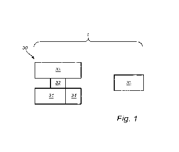
100611 Figure 1 schematically shows a forestry monitoring system 1, according
to an embodiment.
100621 As shown in figure 1, the system 1 comprises a UAV 30 and a computing
device 35. The
UAV 30 comprises an electrical energy storage 31, an electric motor 32 powered
by the electrical
energy storage 31, and a propulsion arrangement 33 driven by the electric
motor 32.
100631 The electrical energy storage 31 may be a battery, one or more
capacitors, or some other
energy storage system, preferably being as energy dense as possible to allow
for the UAV 30 to have
as little weight as possible.
100641 The electric motor 32 may be any suitable type of motor, but again may
preferably be chosen
for lightweight properties to reduce the weight of the UAV 30.
100651 The propulsion an-angement 33 may comprise one or more rotors
respectively attached to one
or more propellers, arranged in such a way as to provide manoeuvrability to
the UAV through and
above the forestry site.
100661 It will be appreciated that the propulsion arrangement 33 and the
electric motor 32 may take
any suitable form to allow for suitable propulsion of the UAV 30 but the
specifics of their
construction are not focussed on herein.
100671 The UAV 30 may further comprise an imaging arrangement 34, which may
include cameras,
sensors and/or the like. The imaging arrangement 34 may be connected in any
many (i.e. rigidly or
moveably) to the UAV 30 and directed (or directable) in such a way to provide
a suitable overview
over a forestry site when the UAV 30 is manoeuvring therethrough or
thereabove.
100681 For example, the imaging arrangement 34 may comprise a stereo camera,
LIDAR, a thermal
imaging camera, and/or other suitable cameras or sensors.
100691 As shown in figure 1, the system 1 may further comprise a computing
device 35 for
processing information collected by the imaging arrangement 34.
CA 03235009 2024-4- 12
WO 2023/067015 10
PCT/EP2022/079124
100701 Although the computing device 35 is shown as a separate element to the
UAV 30, it will be
appreciate that the computing device 35 may instead be attached to the UAV 30
or integrated therein.
In some examples, the computing device 35 may be incorporated into a machine
(or other device) at
the forestry site, for example one or more of the forestry machines. In other
examples, the computing
device 35 may be entirely remote from the forestry site, such as being hosted
in a remote server
environment such as a cloud computing environment or the like.
[0071] The choice as to where the computing device 35 may be situated may
depend on the weight
restrictions of the UAV 30, the data communication capabilities of the UAV
and/or machines and
devices at the forestry site and/or the degree of computational power required
for processing collected
information, to name a few examples.
100721 For example, if the computing device 35 is in an external device such
as a cloud computing
environment, the UAV may comprise a transmitter for transmitting the collected
information to the
computing device 35, or this information may be relayed via short-range
communications to an on-
sire machine, which may then retransmit the information via longer range
communications to the
computing device 35 in the cloud computing environment.
[0073] Figure 2 shows an example overview of a forestry operation at a
forestry site 2, employing a
forestry monitoring system, according to an embodiment.
[0074] The forestry site 2 comprises a number of driving paths 80a, 80b, and
80c. Driving path 80a is
a primary base road, along which an unloading location has been established
for an unloading of logs
for further transport to an onward location. Driving paths 80b and 80c are
alternative routes from the
base road driving path 80a to a harvesting location where a harvester forestry
machine 10 is
harvesting logs.
[0075] As part of the forestry operations undergone at the forestry site 2, a
plurality of self-driving
shuttles 20 may navigate from the unloading location to the harvesting
location (or to/from some
intermediate location, depending on the specific implementation). Thus, a
majority of ground impact
may be caused by a driving of the shuttles 20 along the secondary paths 80b
and 80c.
[0076] The system 1, comprising a UAV 30 being substantially the same or
similar to the UAV
described in relation to figure 1, can make path decisions for the forestry
machines such as the self-
driving shuttles 20, the self-driving unloading crane 40 at the unloading
crane and/or the harvester 10.
The nature of the path decision may vary depending on the forestry machine.
The following
discussion shall focus on the shuttles 20 as an example.
[0077] The driving paths 80 may have been determined by the computing device
(not shown) at a
previous time, or the driving paths may have been created by a human operator
of the harvester 10.
The UAV 30 may collect information about the forestry site 2 and provide this
information to the
computing device for processing, at which point the computing device may
detect the existing driving
paths 80, the forestry machines 10, 20, 40, the creek 81 running through the
forestry site, the
CA 03235009 2024-4- 12
WO 2023/067015 11
PCT/EP2022/079124
unloading location, the harvesting location, a number of trees in the forestry
site, a quality of tree,
and/or other monitoring information that may assist in making path decisions
for the forestry
machines 10, 20, 40.
100781 A shuttle 20 may, after unloading logs at an unloading location, be
instructed to navigate back
to the harvesting location so that the harvester 10 can load more logs onto
the shuttle 20. The location
of the harvester 10 may be provided to the shuttle by the system 1, as well as
a path decision for
navigating thereto.
100791 For example, the shuttle 20 may have an option to choose between
driving path 80b and 80c.
The system 1 may determine a path decision, i.e. path 80b or 80c, based on any
number of relevant
factors.
100801 For example, the system 1 may determine a depth of an impression left
on the driving paths
80b, 80c (i.e. the ground impact caused by the shuttles 20), an amount of
water on the paths 80b, 80c,
(e.g. from the creek 81), and/or a topology of the forestry site 2, to name a
few examples. The
computing device may also be provided with an energy level of the shuttle 20,
which may place a
constraint on a length of a path 80 that the shuttle 20 can travel down before
running out of electrical
energy.
100811 One or more factors may be weighed against each other when determining
the path decision,
for example in the application of ML or AT techniques by the computing device.
To give an example,
path 80b may be determined as having suffered a greater ground impact and
waterlogging, but the
shuttle 20 may communicate that it is low on electrical charge. Thus, the
system 1 may make a path
decision to direct the shuttle 20 down path 80b as an exceptional case, and
direct a subsequent shuttle
20 having sufficient charge along path 80c.
100821 If neither path 80b nor 80c are suitable, according to an assessment by
the computing device,
the shuttle may be instructed to go down a new driving path to the harvester.
100831 Figure 3 schematically shows a UAV 30 coupled to a mobile charging unit
10, according to
an embodiment.
100841 The UAV 30 may be substantially the same or similar to the UAV
described previously in
relation to figures 1 and 2. Figure 3 further shows a mobile charging station
10 having a fuel reservoir
12 and an electrical energy generator 13 fuelled by a fuel from the fuel
reservoir 12. In some
examples, the electrical energy generator 13 may comprise an internal
combustion engine, a fuel cell,
or some other means of electrical energy production.
100851 In examples where the electrical energy generator 13 comprises an
internal combustion
engine, the engine may be operated at an optimum RPM for driving the
electrical energy generator so
as to optimise the energy efficiency of the mobile charging station 10.
100861 The mobile charging station may further comprise a traction arrangement
11 such as a
continuous track or a plurality of wheels. In some examples, the mobile
charging station 10 may be
CA 03235009 2024-4- 12
WO 2023/067015 12
PCT/EP2022/079124
comprised in one of the forestry machines in the forestry site, such as the
harvester 10 shown in figure
2.
[0087] As shown in figure 3, the UAV 30 and the mobile charging station 10 may
each comprise a
respective electrical coupling 23 which, when coupled, enable the charging of
the electrical energy
storage 31 of the UAV 30 via the electrical energy generator 13 of the mobile
charging station 10.
[0088] Although the electrical couplings 23 of the UAV 30 and the mobile
charging station 10 are
shown as being at a lower side and upper side, respectively, it will be
appreciated that this is just one
example placement for the couplings 23.
[0089] In other examples, the coupling 23 of the mobile charging station 10
and/or the UAV 30 may
be on a side surface thereof, or at some other position. Preferably, the
couplings 23 are arranged in
such a way as to allow for a quick engagement/disengagement, preferably under
the UAV's 30 own
action (i.e. without human intervention).
[0090] Although specific examples have been referred to in the figures, it
should be appreciated that
these are not intended to limit the scope of the invention, which instead is
intended to be defined by
the scope of the appended claims.
CA 03235009 2024-4- 12