Sélection de la langue

Search

Sommaire du brevet 2284025 

Énoncé de désistement de responsabilité concernant l'information provenant de tiers

Une partie des informations de ce site Web a été fournie par des sources externes. Le gouvernement du Canada n'assume aucune responsabilité concernant la précision, l'actualité ou la fiabilité des informations fournies par les sources externes. Les utilisateurs qui désirent employer cette information devraient consulter directement la source des informations. Le contenu fourni par les sources externes n'est pas assujetti aux exigences sur les langues officielles, la protection des renseignements personnels et l'accessibilité.

Disponibilité de l'Abrégé et des Revendications

L'apparition de différences dans le texte et l'image des Revendications et de l'Abrégé dépend du moment auquel le document est publié. Les textes des Revendications et de l'Abrégé sont affichés :

  • lorsque la demande peut être examinée par le public;
  • lorsque le brevet est émis (délivrance).
(12) Brevet: (11) CA 2284025
(54) Titre français: PROCEDE DE MESURE UTILISANT LA TECHNIQUE LASER POUR LES OBJETS TRIDIMENSIONNELS
(54) Titre anglais: MEASURING SYSTEM USING LASER TECHNIQUE FOR THREE-DIMENSIONAL OBJECTS
Statut: Périmé et au-delà du délai pour l’annulation
Données bibliographiques
(51) Classification internationale des brevets (CIB):
  • G01S 17/89 (2020.01)
(72) Inventeurs :
  • NIEBUHR, ERIK (Allemagne)
(73) Titulaires :
  • UTEDA - DR. NIEBUHR GMBH
(71) Demandeurs :
  • UTEDA - DR. NIEBUHR GMBH (Allemagne)
(74) Agent: SMART & BIGGAR LP
(74) Co-agent:
(45) Délivré: 2004-01-13
(86) Date de dépôt PCT: 1998-03-23
(87) Mise à la disponibilité du public: 1998-10-01
Requête d'examen: 1999-11-12
Licence disponible: S.O.
Cédé au domaine public: S.O.
(25) Langue des documents déposés: Anglais

Traité de coopération en matière de brevets (PCT): Oui
(86) Numéro de la demande PCT: PCT/DE1998/000833
(87) Numéro de publication internationale PCT: DE1998000833
(85) Entrée nationale: 1999-09-16

(30) Données de priorité de la demande:
Numéro de la demande Pays / territoire Date
197 12 208.6 (Allemagne) 1997-03-24
198 12 431.7 (Allemagne) 1998-03-21

Abrégés

Abrégé français

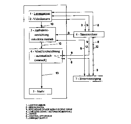
L'invention concerne un système de mesure assisté par laser et destiné aux objets tridimensionnels et surfaces complexes. Selon l'invention, on entend par objets tridimensionnels, de préférence, des espaces intérieurs de bâtiments ou des cavités géologiques aux surfaces complexes. L'invention constitue un apport capital dans la rationalisation et l'amélioration de la précision de telles opérations de mesure. Dans le procédé à durée d'impulsion connu, la distance est mesurée par une impulsion laser envoyée par l'émetteur sur le point de mesure puis renvoyée. L'émission d'impulsions laser génère un éventail de mesure. Selon l'invention, l'éventail de mesure (11) doit être tourné pas à pas de 360 DEG à une vitesse constante pour détecter un espace tridimensionnel. Sur une paroi, on peut obtenir jusqu'à 200.000 points de mesure. Il s'ensuit une évaluation adéquate des données de mesure pour la structure d'un modèle en fils 3-D.


Abrégé anglais


The invention relates to a laser-assisted measuring system for three-
dimensional objects and complex surfaces. In accordance with the invention,
three-
dimensional objects are preferably interior areas of buildings or geological
hollows with complex surfaces. The invention makes a considerable contribution
to the
rationalisation and improvement of precision in measuring operations of this
kind. In the known pulse operation time method, the distance is measured by a
laser
pulse from the transmitter to the measuring point and back. A measurement fan
is generated on emission of laser pulses. In accordance with the invention,
the
measurement tan (11) must be turned 360° step by step at a constant
speed, in order to cover a three-dimensional area. In a wall, up to 200,000
measuring points
can be obtained. An appropriate evaluation of the measurement data takes place
so chat a 3 D wire model can be constructed.

Revendications

Note : Les revendications sont présentées dans la langue officielle dans laquelle elles ont été soumises.


7
CLAIMS:
1. A measuring system using laser technique for
obtaining measurement data of three-dimensional objects in
an interior space, comprising: a laser scanner for emitting
and receiving laser induced pulses containing the
measurement data, wherein said laser scanner creates a
semicircular fan of measuring rays;
a levelling device connected to said laser scanner
for rotating said laser scanner 360 degrees;
a recording device for receiving said measurement
data; and
a measurement data evaluator for digitizing and
placing said measurement data in a mathematical correlation
to its adjacent point, evaluating an existing cloud of
points created by the object in the interior space by
allocating points to clusters, mathematically recording said
correlations in a surface structure by two-dimensional
regression, defining types of planes by analytical
expressions of a plane in space according to position and
enhancement, wherein said planes are combined in such a way
to provide straight lines for constructing a 3D model.
2. The measuring system of claim 1, wherein said
measurement data evaluator is a computer.
3. The measuring system of claim 1, further
comprising a video camera for surveying the object in
parallel with said laser scanner.
4. The measuring system of claim 1, wherein said
semicircular fan of measuring rays is turned 360 degrees
step by step at a constant speed.

8
5. The measuring system of claim 1, wherein said
semicircular fan of measuring rays is turned 360 degrees
step by step at measuring intervals of 0.25 degrees.
6. The measuring system of claim 1, further
comprising a tripod for supporting said measuring system.

Description

Note : Les descriptions sont présentées dans la langue officielle dans laquelle elles ont été soumises.


CA 02284025 1999-09-16
I:ILE, THIS 1~-'
'TR~t~SL~TIt~~
WO 98143113 PCTIDE98100833
Measuring system using laser technique for three-dimensional objects
The present invention relates to a measuring system using laser technique for
three-dimensional objects
and complex surfaces. According to the invention, three-dimensional objects
are preferably interior rooms
in buildings with central stairwells and corridors, i.e. all interior rooms
from basements to attics. Geological
hollows with complex surfaces shall be cited as further examples whose
surveying is possible with the
novel measuring system using laser technique.
For the professional groups architecture, building trade, expert consultants
and restorers but also
surveying firms, geologists and archaeologists the manual n~easuriiig out of
existing interior spaces (the
so-called "measuring up") or natural hollows is a frequently occurring and
often rather complicated working
process which entails considerable time and pt~rsonnel efforts. In addition
the "human" factor brings about
errors and measuring inaccuracies that can only be corrected by repeated
measuring. It can be stated in
this context that the commonly used procedure, in which only an insufficient
number of measuring points
are determined manually, makes further inaccuracies in the sense of a true
representation of deformation
unavoidable.
It is a known fact that surveying of buildings has been conducted by means of
photogrammetry for years.
The following facts shall be stated regarding the above method:
~ The evaluation of the measurements which are available as digitised photos
has only been partially
automated to date, while essentially the recognition and determination of the
object boundaries (i.e.
visible edges and valleys) is done manually.
~ It is due to the limited aperture angle andlor the strong boundary
distortions in case of large aperture
angles ("fisheye") that nearly exclusively facades or architectural details
are measured.
~ The high manual efforts and the pertaining costs are very high. In addition,
the currently available
measuring methods only allow for the determination of max. 3,000 measuring
points per working day.

CA 02284025 1999-09-16
WO 98143113 PCTIDE98100833
2
One measuring method in which laser technique is adopted is the pulse
operation time method in which an
extremely short light-induced pulse is emitted from a laser source and
deflected via a mirror which rotates
at a high angular speed. Said light-induced pulses are reflected by an object
to be measured that is
located at a max. distance of 50 m and recorded by an existing receiver in a
laser scanner. The period of
time between the emitting and receiving is measured and thus the distance to
the scanned measuring
object is determined for each ray and for each point on the scanned surface.
This measuring method by
means of a singular light-induced pulse from a transmitter to a measur ing
point and back to a receiver is
called "pulse operation time method".
In this connection it is referred to DE 43 40 756 A 1, titled "Distance
measurement using lasers". A laser
radar is equipped with a pulsed laser, that emits controlled light-induced
pulses into a measuring range, a
photo receiver arrangement, which receives the light-induced pulses that are
reflected by an object located
in the measuring range, and an evaluation circuit which, under consideration
of the velocity of light, uses
the time period between the emission and reception of a light-induced pulse to
determine a distance signal
which is characteristic for the distance of the object. A light deflecting
arrangement is positioned between
the measuring range and the pulsed laser, said arrangement guides the light-
induced pulses into the
measuring range under increasingly modifying angles and simultaneously emits
an angle position signal to
the evaluation circuit that is representative for the instantaneous angle
position. The evaluation circuit uses
the distance signal and the angle position signal to determine the location of
the object within the
measuring range.
The quantity of the distance values obtained in a plane over a semicircle is
hereunder referred to as
"measurement fan".
The examples cited show that it is not possible to measure three-dimensional
spaces rationally and with
sufficient accuracy, as for instance required for measuring up operations, and
true to deformation by
applying sophisticated equipment and techniques, such as digital cameras or
laser technique. In case of
larger three-dimensional objects it is not possible to edit exact measurement
values in the office in the
sense of an integrated data system in such a way that thus all dimensions of a
three-dimensional object
are available for further processing. As explained earlier, also the
evaluation of digitised photos (which can
only be partially automated) is not a fundamental simplification of the
measurement of such objects.

CA 02284025 2002-11-19
29851-1
3
In accordance with DE 42 10 245 C2 a topographic
recording system for an aerodynamic vehicle in order to scan
the terrain is described. This is a topographic measurement
method that requires the absolute coordinates to evaluate
the measured data. The former are made available by GPS
systems and INS (inertial navigation system) with which
aircraft are equipped. As the prior state of the art, the
above-mentioned DE 42 10 245 C2 states that by seeking
homologous picture elements in a downstream signal
preparation stage it is thus possible to use the picture
signals to calculate the flight orientation data required
for the evaluation in all six degrees of freedom and to
create either stereoscopic image strips or a three-
dimensional model of the overflows terrain in a digitised
format. The further development of the prior state of the
art by the invention in accordance with DE 42 10 245 C2 the
absolute coordinates are still necessary. The seeking of
homologous picture elements for the calculation of
stereoscopic image strips is carried out with a linear-array
camera and a distance sensor with a downstream signal
processing stage. The correlation of homologous picture
elements, however, requires very extensive calculation
efforts and proposals are put forward as to how to remedy
this situation.
The topographic recording system takes
measurements in parallel strips in this method, which in no
case is suited for 3D interior space visualisation and
surveying.
The present invention is based on the task of
proposing a measuring system preferably for interior spaces
with which a single, automated optical measurement and
computer-assisted evaluation are made and thus all measuring

CA 02284025 2002-11-19
29851-1
3a
data - also of complex objects - are available. In this
context, the present invention is also based on the task of
facilitating a complete visualisation of a 3D space from the
digital measurement data.
In accordance with the present invention, there is
provided a measuring system using laser technique for
obtaining measurement data of three-dimensional objects in
an interior space, comprising: a laser scanner for emitting
and receiving laser induced pulses containing the
measurement data, wherein said laser scanner creates a
semicircular fan of measuring rays; a levelling device
connected to said laser scanner for rotating said laser
scanner 360 degrees; a recording device for receiving said
measurement data; and a measurement data evaluator for
digitizing and placing said measurement data in a
mathematical correlation to its adjacent point, evaluating
an existing cloud of points created by the object in the
interior space by allocating points to clusters,
mathematically recording said correlations in a surface
structure by two-dimensional regression, defining types of
planes by analytical expressions of a plane in space
according to position and enhancement, wherein said planes
are combined in such a way to provide straight lines for
constructing a 3D model.
In addition to the above the following is
explained regarding the system according to the invention:
The measurement fan is located vertically and moved
horizontally. This mode of action yields a large amount of
points located in a lattice-like structure on the limiting
surfaces of a spherical environment, including their
distances to the measuring point.

CA 02284025 1999-09-16
WO 98143113 PCTIDE98100833
4
The measurement fan must be turned 360° in order to cover a three-
dimensional space. In order to obtain
a number of measured points which are necessary for the accuracy required in
practical applications
measuring distances of 0.25° are to be used while turning the
measurement fan.
The measured data of the individual measurement fans are transmitted to a
control computer in real time.
The large number of measurement data obtained and by means of statistical
equalisations made by the
evaluation software make sure that an appropriate accuracy is achieved as is
an acceptable time for an all-
round measurement. The total surveying time for a complete interior space is
approx. 4 minutes, with the
system providing a variable speed of the turning device. The latter makes it
possible to adapt the
measuring process to local requirements. According to the process described
each measured value can be
digitised and is in a mathematical correlation to its adjacent point. The
evaluation of the existing cloud of
points created by the surface of the interior space shell is made by
allocating the points to clusters. Said
correlations are mathematically recorded in a surface structure via two-
dimensional regression. Thus, the
analytical expression of a plane in the space is formed. According to the
position and the enhancement
different types of planes can be defined. All planes are combined, their
planes of section provide straight
lines for the construction of a 3 D wire model with dimensions as a CA~~
drawing true to deformation.
Moreover, in parallel to an all-round survey with a laser scanner the space to
be measured can also be
additionally covered with a digital camera. The digital images can supply
additional information in the
working step "evaluation of the measurement data" and during any possible re-
processing of the object
data. In addition, photo-realistic representations of the measured objects can
be supplementary created
during presentations of the object data.
In the following a practical example is described to explain the invention.

CA 02284025 1999-09-16
WO 98143113 PCT1DE98100833
The individual figures show the following:
Figure 1 Block diagram according to the measuring system
Figure 2 Levelling device with representation of the measurement fan movement
Figure 3 Arrangement of the measuring points
The reference signs used have the following meanings:
1 Laserscanner
2 Video camera
3 Recording device
4 Levelling device
5 Tripod
6 Control computer
7 Power supply
8 Flow of energy
9 Flow of information
Connection of substances (mechanical connection)
11 Measurement fan
12 Automatic interruption
The laser scanner 1 which operates with the pulse operation time method is
capable of measuring the
distance of a given object with an accuracy of ~ 1 mm in the range of a 200 m
diameter. Appropriate
control of the laser scanner 1 during the measuring process ensures that all
surfaces of a space are
measured individually. In Fig. 2 it can be seen which lighi-induced pulses are
required for a fan-like
representation (measurement fan 11 ) and how the measurement fan 11 is turned
360°.
The tripod 5 holds the levelling device 4, the recording device 3 for the
laser scanner 1 and the video
camera (digital camera). The connection of substances 10 between said
components is made by
mechanical connections.
According to Fig. 1 the flow of energy 8 can be seen starting from the power
supply 7. The flow of
information 9 runs between the control computer 6 and the automatic levelling
device 4, between the
control computer 6 and the recording device 3 (with electric drive) as well as
between the control

CA 02284025 1999-09-16
WO 98143113 PCTIDE98100833
6
computer and the laser scanner 1 and further the video camera. Position sign
12 denotes an automatic
interruption and resetting to "0" = start in case of inaccuracies.
It is emphasised that the recording device continually turns 360° in
0.25° steps. During said turning the
direction of the measurement fan is no longer orthogonally to the horizontal
direction of rotation but as
sketched in Fig. 3. Due to the fact that a number of subsequently made
measurements fail to reach the
same points the equalisation of measurement data that is made internally in
the laser scanner cannot be
used. However, the large number of measurement data obtained a statistical
equalisation can be made by
the evaluation software. Thus an appropriate accuracy of the results is
achieved after their evaluation.
The evaluation of the measurement data is made in the evaluation computer
completely independent of
the time of their acquisition. The evaluation program carries out - if
required in a dialog with the editor - the
recognition of the individual elements of the object. In doing so, the
measuring points are allocated to the
limiting surfaces of a space. In the process the dispersion of the measurement
data is also taken into
consideration and the accuracy is irnproved by mean value generation of the
extensive numerical material
(approx. 100,000 to 200,000 values per wall).
In case of complex structures and critical measuring points, such as the
starting points of the adjacent
measurements, the editor can monitor and, if need be, correct the
interpretation by making comparisons
with the shots made with the digital camera which are displayed on the screen
synchronously with the
measured values and the elements that are already recognised.
The data of the individual spaces are combined with each other and assembled
into a model of the entire
object (thus, for instance the limiting surfaces of adjacent spaces are made
into walls between said
spaces). In case of several starting points within one space the same
procedure is adopted. All walls are
resolved into individual segments which are made up of basic geometric shapes.
While doing so, matching
elements are recognised. In addition, the editor has the opportunity to
manipulate this process via the
dialog function. The result of this working step is a file in "DXF" format
which represents the measured
object as a 3 D drawing and can be directly used, e.g., with the AutoCad
program.

Dessin représentatif
Une figure unique qui représente un dessin illustrant l'invention.
États administratifs

2024-08-01 : Dans le cadre de la transition vers les Brevets de nouvelle génération (BNG), la base de données sur les brevets canadiens (BDBC) contient désormais un Historique d'événement plus détaillé, qui reproduit le Journal des événements de notre nouvelle solution interne.

Veuillez noter que les événements débutant par « Inactive : » se réfèrent à des événements qui ne sont plus utilisés dans notre nouvelle solution interne.

Pour une meilleure compréhension de l'état de la demande ou brevet qui figure sur cette page, la rubrique Mise en garde , et les descriptions de Brevet , Historique d'événement , Taxes périodiques et Historique des paiements devraient être consultées.

Historique d'événement

Description Date
Inactive : CIB enlevée 2020-09-16
Inactive : CIB en 1re position 2020-09-16
Inactive : CIB attribuée 2020-09-16
Inactive : CIB expirée 2020-01-01
Inactive : CIB enlevée 2019-12-31
Le délai pour l'annulation est expiré 2007-03-23
Lettre envoyée 2006-03-23
Inactive : CIB de MCD 2006-03-12
Accordé par délivrance 2004-01-13
Inactive : Page couverture publiée 2004-01-12
Préoctroi 2003-10-23
Inactive : Taxe finale reçue 2003-10-23
Un avis d'acceptation est envoyé 2003-05-28
Lettre envoyée 2003-05-28
Un avis d'acceptation est envoyé 2003-05-28
Inactive : Approuvée aux fins d'acceptation (AFA) 2003-04-28
Modification reçue - modification volontaire 2002-11-19
Inactive : Dem. de l'examinateur par.30(2) Règles 2002-05-21
Inactive : Grandeur de l'entité changée 2002-01-11
Lettre envoyée 2000-11-24
Inactive : Transfert individuel 2000-10-23
Lettre envoyée 1999-11-26
Inactive : Page couverture publiée 1999-11-19
Requête d'examen reçue 1999-11-12
Exigences pour une requête d'examen - jugée conforme 1999-11-12
Toutes les exigences pour l'examen - jugée conforme 1999-11-12
Inactive : CIB en 1re position 1999-11-05
Inactive : Lettre de courtoisie - Preuve 1999-10-26
Inactive : Notice - Entrée phase nat. - Pas de RE 1999-10-20
Demande reçue - PCT 1999-10-18
Demande publiée (accessible au public) 1998-10-01

Historique d'abandonnement

Il n'y a pas d'historique d'abandonnement

Taxes périodiques

Le dernier paiement a été reçu le 2003-11-13

Avis : Si le paiement en totalité n'a pas été reçu au plus tard à la date indiquée, une taxe supplémentaire peut être imposée, soit une des taxes suivantes :

  • taxe de rétablissement ;
  • taxe pour paiement en souffrance ; ou
  • taxe additionnelle pour le renversement d'une péremption réputée.

Les taxes sur les brevets sont ajustées au 1er janvier de chaque année. Les montants ci-dessus sont les montants actuels s'ils sont reçus au plus tard le 31 décembre de l'année en cours.
Veuillez vous référer à la page web des taxes sur les brevets de l'OPIC pour voir tous les montants actuels des taxes.

Historique des taxes

Type de taxes Anniversaire Échéance Date payée
Taxe nationale de base - petite 1999-09-16
TM (demande, 2e anniv.) - petite 02 2000-03-23 1999-10-21
Requête d'examen - petite 1999-11-12
TM (demande, 3e anniv.) - petite 03 2001-03-23 2000-10-18
Enregistrement d'un document 2000-10-23
TM (demande, 4e anniv.) - générale 04 2002-03-25 2001-12-18
TM (demande, 5e anniv.) - générale 05 2003-03-24 2003-03-18
Taxe finale - générale 2003-10-23
TM (demande, 6e anniv.) - générale 06 2004-03-23 2003-11-13
TM (brevet, 7e anniv.) - générale 2005-03-23 2005-01-12
Titulaires au dossier

Les titulaires actuels et antérieures au dossier sont affichés en ordre alphabétique.

Titulaires actuels au dossier
UTEDA - DR. NIEBUHR GMBH
Titulaires antérieures au dossier
ERIK NIEBUHR
Les propriétaires antérieurs qui ne figurent pas dans la liste des « Propriétaires au dossier » apparaîtront dans d'autres documents au dossier.
Documents

Pour visionner les fichiers sélectionnés, entrer le code reCAPTCHA :


Pour visualiser une image, cliquer sur un lien dans la colonne description du document (Temporairement non-disponible). Pour télécharger l'image (les images), cliquer l'une ou plusieurs cases à cocher dans la première colonne et ensuite cliquer sur le bouton "Télécharger sélection en format PDF (archive Zip)" ou le bouton "Télécharger sélection (en un fichier PDF fusionné)".

Liste des documents de brevet publiés et non publiés sur la BDBC .

Si vous avez des difficultés à accéder au contenu, veuillez communiquer avec le Centre de services à la clientèle au 1-866-997-1936, ou envoyer un courriel au Centre de service à la clientèle de l'OPIC.

({010=Tous les documents, 020=Au moment du dépôt, 030=Au moment de la mise à la disponibilité du public, 040=À la délivrance, 050=Examen, 060=Correspondance reçue, 070=Divers, 080=Correspondance envoyée, 090=Paiement})


Description du
Document 
Date
(aaaa-mm-jj) 
Nombre de pages   Taille de l'image (Ko) 
Dessin représentatif 1999-11-18 1 11
Description 2002-11-18 7 352
Revendications 2002-11-18 2 51
Description 1999-09-15 6 313
Dessins 1999-09-15 3 75
Revendications 1999-09-15 1 45
Abrégé 1999-09-15 1 17
Accusé de réception de la requête d'examen 1999-11-25 1 178
Avis d'entree dans la phase nationale 1999-10-19 1 193
Demande de preuve ou de transfert manquant 2000-09-18 1 110
Courtoisie - Certificat d'enregistrement (document(s) connexe(s)) 2000-11-23 1 113
Avis du commissaire - Demande jugée acceptable 2003-05-27 1 160
Avis concernant la taxe de maintien 2006-05-17 1 172
Correspondance 1999-10-19 1 15
PCT 1999-09-15 12 468
Correspondance 2003-10-22 1 32