Note : Les descriptions sont présentées dans la langue officielle dans laquelle elles ont été soumises.
CA 02313044 2000-06-O1
WO 99/30448 PCT/US98/17473
-1-
METHOD AND APPARATUS FOR PREDICTING SIGNAL
CHARACTERISTICS IN A WIRELESS COMMZTNICATION
SYSTEM
Field of the Invention
This invention relates generally to communication
systems, and, more particularly, to a method and
apparatus for predicting signal characteristics in a
wireless communication system.
Background of the Invention
Microcells, which are usually small, low-power
radio base stations having small coverage areas, may be
used to provide wireless communications in localized
areas. Microcells may be coupled to larger base
stations, or macrocells, through digital radio
transmission or optical fibers. A typical cell site,
either a microcell or a macrocell, includes one or more
transceivers and a transmitter such as an antenna, and
supplies communication.services to subscribers within a
designated coverage area of the cell site.
Designing a communication system which includes
both microcells and macrocells requires selecting
geographic locations of transmitters, their desired
coverage areas and their signal radiation patterns, so
that specific frequencies, such as radio frequencies
(RFs), are present within each cell's designated
coverage area, while interference with other coverage
areas sharing the same or.similar frequencies is
minimized.
Prediction of actual signal propagation patterns
into and out of cells may be difficult, however, because
buildings and other terrain irregularities may reflect
CA 02313044 2000-06-O1
WO 99/30448 PCT/US98/17473
-2-
signals in unanticipated directions, resulting in
insufficient signal
strength in a one cell's designated coverage area and/or
unacceptable levels of interference in another cell's
coverage area.
Several software tools are available which predict
signal propagation paths and aid in planning the
physical layout of a wireless communication system.
Examples of such tools include, but are not limited to,
10 Motorola's Netplan~'M RF system planning and management
tool, Mobile Systems, Inc.'s PlaNetTM RF coverage tool,
LNS's RF planning tool and a commercially available
raytracing tool developed by T. Rappaport. Currently,
however, these and other software tools may not be
15 suitable for use in planning all types of communication
systems.
First, environmental models or high-resolution maps
which model, typically via information stored in a
database, areas of interest within a geographic area
20 associated with the communication system and are used to
predict signal characteristics at a particular location
are different for macrocells than for microcells. For
example, macrocellular maps typically require less
resolution (or variable layers of resolution) than
25 microcellular maps, which typically are modeled using
high resolution databases.
Second, simplistic pathloss equations and
empirical, or statistical, propagation models, are
generally used in connection with predicting signal
30 characteristics, such as signal strength, associated
with macrocells; while for microcells more sophisticated
ray tracing techniques, or deterministic models, are
used to predict signal characteristics such as actual
signal propagation paths. In general, databases
35 associated with macrocellular propagation models are in
different coordinate systems and/or formats than
CA 02313044 2000-06-O1
WO 99/30448 PCTNS98/17473
-3-
databases associated with micorcellular propagation
models.
Although possible, it may be time consuming and
expensive to manually select and field test different
combinations of frequencies, signal radiation patterns
and/or signal powers to obtain complete coverage and
acceptable interference levels for each cell in a
communication system which includes both microcells and
macrocells.
10 There is therefore a need for a method and
apparatus for predicting signal characteristics in a
communication system having both microcelis and
macrocells which integrates maps having different
resolutions into a single map having a single coordinate
15 system, and which adaptively adjusts the prediction of
signal characteristics based on the location of a
particular point of interest.
Suaunary of the Inveation
According to an aspect of the present invention,
the foregoing need is addressed by a method for
predicting a characteristic of first and second signals
at a predetermined location within a geographic area,
25 which operates in a wireless communication system
serving the geographic area, the wireless communication
system including the first transmitter and he second
transmitter, the first transmitter a microcellular
transmitter configured to transmit a first signal having
30 a first wavelength and the second transmitter a
macrocellular transmitter configured to transmit a
second signal having a second wavelength. The method
includes positioning representations of the first and
second transmitters; defining an environmental model of
35 the geographic area; defining a plurality of facets
within the environmental model, each of the plurality of
CA 02313044 2000-06-O1
Vi~O 99/30448 PC'TNS98/17473
-4-
facets comprising at least three points defining a plane
and having a size, at least one facet associated with
the predetermined location; providing a first technique
for predicting the characteristic; providing a second
technique for predicting the characteristic; based on
the size of the at least one facet associated with the
predetermined location, on the first wavelength and the
second wavelength, using one of the first technique and
the second technique to predict the characteristic at
the predetermined location; and based on the prediction,
modifying a parameter associated with the wireless
communication system.
According to another aspect of the present
invention, in a wireless communication system serving a
geographic area, an apparatus for calculating a
characteristic of a first signal and a second signal at
a predetermined location within the geographic area
includes a memory for storing representations of a
microcellular transmitter and a macrocellular
transmitter. The representation of the microcellular
transmitter is configured to transmit a representation
of the first signal and the representation of the
macrocellular transmitter is configured to transmit a
representation of the second signal. A database is
responsive to the memory. The database has a plurality
of data structures, and the plurality of data structures
comprise a map of the geographic area. The
predetermined location is positioned on the map. A
facet is associated with the predetermined location.
The facet has a size and comprises at least three points
defining a plane. A first instruction set for
calculating the characteristic and a second instruction
set for calculating the characteristic are provided. A
processor is responsive to the memory and the database,
and the processor uses one of the first instruction set
CA 02313044 2000-06-O1
WO 99/30448 PCT/US98/17473
-5-
and the second instruction set to calculate the
characteristic at the predetermined location.
According to a further aspect of the present
invention, in a wireless communication system serving a
geographic area, the wireless communication system
including a first transmitter and a second transmitter,
the first transmitter a microcellular transmitter
configured to transmit,a first signal and the second
transmitter a macrocellular transmitter configured to
transmit a second signal, an apparatus for determining a
characteristic of the first and second signals at a
predetermined location within the geographic area
includes means for positioning representations of the
first and second transmitters; means for defining an
environmental model of the geographic area; means for
defining a plurality of facets within the environmental
model, each of the plurality of facets comprising at
least three points defining a plane and having a size,
at least one facet associated with the predetermined
location; first means for predicting the characteristic;
second means for predicting the characteristic; and
means for selecting one of the first means for
predicting and the second means for predicting to
determine the characteristic at the predetermined
location, the selection based on the size of the at
least one facet associated with the predetermined
location and based on a wavelength of the first and
second signals.
Advantages of the present invention will become
readily apparent to those skilled in the art from the
following description of the preferred embodiments) of
the invention which have been shown and described by way
of illustration. As will be realized, the invention is
capable of other and different embodiments, and its
details are capable of modifications in various
respects. Accordingly, the drawings and description are
CA 02313044 2000-06-O1
WO 99/30448 PCTNS98/17473
-6-
to be regarded as illustrative in nature, and not as
restrictive.
Brief Description of the Drawings
FIG. 1 is a diagram of a typical cellular
communication system including both macrocells and
microcells.
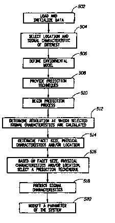
10 FIG. 2 is a flowchart of a method for predicting
signal characteristics according to a preferred
embodiment of the present invention.
FIG. 3 is a top view of an environmental model
which illustrates how buildings and other terrain
irregularities may reflect antennae beam patterns in
various directions.
FIG. 4 is a graphical representation of a facet
20 which may represent a portion of the environmental model
shown in FIG. 3.
FIG. 5 is a block diagram of an apparatus for
predicting signal characteristics in accordance with a
preferred embodiment of the present invention.
Detailed Description of the Preferred Embodimeats
Turning now to the drawings, wherein like numerals
designate like components, FIG. 1 is a diagram of a
typical cellular communication system 200. A number of
mobile communication units (not shown), or mobile
stations, may operate in areas 412, 414 or 416 served
by base stations 312, 314 and 316, respectively. Base
35 stations 314 and 316, along with corresponding areas
414 and 416, respectively, are microcells, while base
CA 02313044 2000-06-O1
WO 99/3044$ PC'T/US98/17473
-
station 312 and corresponding area 412 is a macrocell.
Collectively, service areas 412, 414 and 416 cover a
particular geographic area 400.
A number of points 11, or measurable regions, which
may in fact represent areas of particular sizes or
centers of specified areas in space, are shown within
geographic area 400. Points 11 may be located anywhere
within area 400. Any number of points 11 may be
identified within area 400, and it may be assumed that
mobile stations operate at points 11. Neighboring
service areas 412, 414 and 416 may be overlapping (as
shown) or substantially adjacent to each other. It is
contemplated that base stations 312, 314 and 316 may be
sectors of a sectored base station (not shown), or may
themselves be sectored base stations, but in general are
devices having transmitters such as antennae capable of
emitting radio signals throughout an area over which
communication is to be established. Wherever radio
frequency channels are referred to herein, such channels
are understood to refer to channels in code-based radio-
frequency communication systems, as well as channels in
frequency-based systems.
A base station such as base station 312, 314 or
316, which is commercially available from Motorola,
Inc., may include, among other things, a plurality of
transceivers (not shown) which provide communication
channels for communication between mobile communication
units and base stations 312, 314 and 316, and may also
include a transmitter such as an antenna 19 which
transmits and receives communication signals. Multiple
frequencies, for example, multiple voice and signaling
channels, may be transmitted from a single antenna 19,
using well-known combining methods. Antennae 19 may be
any type, for example, directional-beam, uni-beam, omni-
beam, patch or array, and its transmit power and/or
CA 02313044 2000-06-O1
WO 99/30448 PCT/US98/17473
_g_
phasing may be controlled using various well-known
techniques.
One or more of base stations 312, 314 and 316 may
be in communication with a base station controller (not
5 shown), such as a Motorola base station controller,
having a well-known structure and function, or may
itself be a complete base station system. Additional
base stations may also be coupled to the base station
controller, when present. The base station controller
10 or base station system may in turn be in communication
with a switch (not shown), which may be a mobile
switching center such as an EMXZ'M 2500, commercially
available from Motorola, or another suitable type of
switch. Additional base station controllers (not shown)
15 or base station systems may also be coupled to the
switch. The switch may be in further communication
with, among other things, a public switched telephone
network (PSTN) (not shown), allowing mobile
communication units to access land-based communication
20 lines and vice versa.
Multiple access wireless communication between base
stations 312, 314 and 316 and mobile stations
preferably occurs over radio frequency (RF) channels
which provide physical paths over which communication
25 signals such as voice, data and video are transmitted.
Base-to-mobile station communications are said to occur
on a forward-link channel, while mobile-to-base station
communications are referred to as being on a reverse-
link channel. A communication channel may be, among
30 other things, a pilot channel, a paging channel, a synch
channel, a traffic channel or part of a traffic channel.
When planning a wireless communication system such
as system 200 depicted in FIG. 1, it is critical to
properly select the geographic locations of base
35 stations 312, 314 and 316 and the approximate
boundaries of coverage areas 412, 414 and 416 so that
CA 02313044 2000-06-O1
WO 99/30448 PCT/US98/17473
-g_
suitable signals, such as radio frequency signals,
propagate from antennae 19 to most every point in
desired coverage areas 412, 414 and 416 without causing
undue interference in the form of adjacent channel or
5 cochannel interference. General considerations involved
in designing a wireless communication system such as a
cellular radiotelephone network are described in "The
Communications Handbook," Jerry D. Gibson, Editor-in-
Chief, CRC Press (1997), Chapter 81, pp. 1146-1159,
incorporated herein by reference.
If characteristics of signals transmitted from
antennae 19 can be accurately predicted, it is likely
that base stations 312, 314 and 316 will be properly
located. As is well-known, signal characteristics, and
15 thus shapes and sizes of coverage areas 412, 414 and
416 may, in addition to being dependent on the location
of buildings and other terrain irregularities, vary as a
function of availability of sites to place antennae 19
and traffic congestion.
20 According to one aspect of the present invention, a
method, a flowchart of which is illustrated in FIG. 2
(and further described with reference to FIG. 1 and
other figures as necessary), provides for predicting
signal characteristics in a wireless communication
25 system such as system 200 having both macrocells and
microcells and mixed resolution databases, so that,
among other things, desirable signal characteristics
associated with each base station 312, 314 and 316
exist at points 11.
30 At block 502, the step of loading and initializing
data is performed. This step may include, among other
things, representing base stations 312, 314 and 316 in
machine-readable format and selecting initial geographic
locations of the representations of base stations 312,
35 314 and 316, along with approximations of coverage
areas 412, 414 and 416 based on different attenuation
CA 02313044 2000-06-O1
WO 99/30448 PCT/US98/17473
-10-
levels. An initial set of transmit power values
associated with antennae 19 of base stations 312, 314
and 316 and particular frequencies of signals
transmitted by antennae 19 may also be assumed. For
example, cellular radiotelephones currently operate in
the 890 1~-Iz range and also in the 1.9 GHz range,
although other frequencies may be specified. If there
is an object in the near-field of a particular antenna,
then a library of antenna patterns may be used which has
been pre-generated using a numerical method such as
finite difference time domain (FDTD) or finite element
method (FEM).
The method continues at block 504, where one or
more areas of interest, or a predetermined locations,
are selected. For example, one or more points 11 may
constitute an area of interest. One or more signal
characteristics of interest may also be selected at
block 504. Examples of signal characteristics include,
but are not limited to, signal strength, signal
propagation path, signal interference and signal
polarization.
Next, at block 506, an environmental model, or map,
of geographic area 200 is defined. An example of an
environmental model 300 is shown in FIG. 3. As shown,
objects which can redirect a propagating signal,
including but not limited to buildings 304, 306, 308
and 310, are located in relation to an antenna 19,
which may be associated with one of base stations 312,
314 or 316. Location, size and composition of objects
such as buildings, terrain elevation and natural objects
such as trees, water and rocks may be modeled in three-
dimensions and stored in a database. Diffraction,
reflection and diffusion scattering coefficients in 3
dimensions of various objects such as known surfaces and
inhomogeneous rough surfaces are preferably developed
using numerical methods such as finite difference time
CA 02313044 2000-06-O1
WO 99/30448 PCT/US98I17473
-11-
domain (FDTD) analysis or finite element analysis--
different materials are modeled with scattering
coefficients, which are in turn used to predict
characteristics of reflected or diffracted signals.
FDTD and/or other numerical methods may also be used to
develop realistic antenna patterns which include the
effects of walls, wedge shapes and corners when they
exist in the near field of an antenna. Certain
permitivities or dielectric properties of an object
being modeled may be assumed, and coefficients may be
extracted using a supercomputer. These coefficients may
then be stored, for future use, as data structures in a
database. For example the extracted coefficients may be
stored in a well-known format such as a lookup-table.
One approach to three-dimensional modeling is
described in "Integrated Macro and Microcellular
Propagation Model, Based on the Use of Photogrammetric
Terrain and Building Data," by E.K. Tameh et al., IEEE
(1997), pp. 1957-1961, incorporated by reference herein.
A propagation model for coverage prediction in the very
high frequency and ultra high frequency ranges which
considers uses a three-dimensional terrain data bank is
presented in "A Versatile Wave Propagation Model for the
VHF/UHF Range Considering Three-Dimensional Terrain," by
M. Lebherz et al., IEEE Transactions on Antennas and
Propagation, Vol. 40, No. 10, October 1992, pp. 1121-
1131, incorporated herein by reference. Other articles
concerning propagation and/or environmental models
include: "Two-Dimensional Ray-Tracing Modeling for
Propagation Prediction in Microcellular Environments,"
K. Rizik et al., IEEE Transactions on Vehicular
Technology, Vol. 46, No. 2, May 1997, pp. 508-517;
"Simulation of Radio Relay Link Performance Using a
Deterministic 3D Wave Propagation Model," by N. Geng et
al., Radio Relay Systems, C11-14 October 1993,
Conference Publication No. 386, IEEE, pp. 343-348;
CA 02313044 2000-06-O1
WO 99/30448 PC'T/US98/17473
-12-
Concepts and Results for 3D Digital Terrain-Based Wave
Propagation Models: An Overview," T. Kurner et al.,
IEEE Journal on Selected Areas in Communications, Vol.
11, No. 7, Sept. 1993; "Finite-Difference Time-Domain
Method for Electromagnetic Radiation, Interference, and
Interaction with Complex Structures," P.A. Tirkas et
al., IEEE Transactions on Electromagnetic Compatibility,
Vol. 35, No. 2, May 1993; "A Microcellular
Communications Propagation Model Based on the Uniform
Theory of Diffraction and Multiple Image Theory," S.Y.
Tan et al., IEEE Transactions on Antennas and
Propagation, Vol. 44, No. 10, October 1996; and "A Monte
Carlo FDTD Technique for Rough Surface Scattering," J.B.
Schneider et al., IEEE Transactions on Antennas and
Propagation, Vol. 43, No. 11, November 1995. Each of
these articles is incorporated herein by reference.
Preferably, environmental model 300 accomodates
different resolutions for different regions within
geographic area 200. For example, in a rural flat area
a resolution of 100-200 meters may be adequate, while a
10 meter or better resolution may be required in an
urban area or areas having irregular terrain. It is
desirable to achieve such a non-homogeneous map while
retaining a single coordinate system. Data collected
through various means such as satellite, maps and aerial
photographs, among other means, are generally
represented in an ellipsoid coordinate system or a
spherical coordinate system. It is preferable to
transform the ellipsoid coordinate system into a
rectangular coordinate system and to use only
rectangular (Cartesian) coordinate physics.
Geographical data is preferably separated and
classified into rural, urban and mixed areas. Rural
areas are further classified based on land cover and
elevation. Examples of land cover include forests
(having a certain density of trees per area), lakes,
CA 02313044 2000-06-O1
WO 99/30448 PCTNS98/17473
-13-
open dry lands and open wetlands. Examples of elevation
include flat areas, flat areas having particular
irregularities or roughness, hilly areas and mountainous
terrain. Urban areas may be classified based on
building density, defined, for example, by typical U.S.
cities, European cities and suburban areas. Each class
of data may be assigned its own reflection coefficient
and/or diffusion coefficient, and transition regions may
also be defined.
At block 508, prediction techniques are provided
which simulate the redirection, that is, the reflection,
diffraction or diffusion, of a signal 28 within
environmental model 300. A first technique for
predicting a characteristic of signal 28 transmitted
from one or more antennae 19 is a deterministic
technique, which includes the use of mathematical
formulas, such as three-dimensional scattering
calculations, which describe physical phenomena. The
use of such calculations is commonly referred to as
raytracing. Typically, the underlying calculations are
based on the uniform theory of diffraction or
geometrical/physical optics, that include plane wave
equations characteristics, described in the rectangular
coordinate system.
According to a preferred embodiment of the present
invention, energy radiated from an antenna is treated as
energy density, i.e., watts per square meter. Such
radiated energy hits an object such as a wall at a
surface rather than at a point. As a result, currents
may be induced at the surface, which currents re-
radiate. The nature of the surface (i.e., its material
and geometry) determines the surface currents. A
direction of the re-radiated energy, and information
about the new signal characteristics (e. g., polarization
state, signal strength, signal amplitude), is detected.
For example, a vertically-polarized signal may
CA 02313044 2000-06-O1
WO 99/30448 PCT/US98117473
-14-
depolarize after reflecting off of a dielectric or
inhomogeneous object. It is preferable to predict a
degree of polarization or depolarization based on a
library of facets (discussed further below), each of
5 which has a particular material composition and
inhomogenuity, so that when an incident signal strikes a
certain facet at a particular polarization, the
polarization state of the reflected signal may be known
or selected. Such a technique and/or library is
10 commonly referred to as a polarometric scattering
matrix.
Alternatively, attenuation of a signal such as
signal 28 may be deterministically predicted using the
well-known method of images, or the well-known dot
15 product method. A detailed description of the method of
images may be found in U.S. Patent Applications Nos.
08/701,257, 08/656,029, 08/415,051 and 08/685,344,
commonly assigned with the present invention. Each of
the above-referenced U.S. Patent Applications is
20 incorporated herein by reference.
A second technique for predicting the
characteristic of signal 28 is a statistical/empirical
technique, which preferably involves the use of
numerical methods. Examples of numerical methods
25 include FDTD, finite element methods (FEM) or the method
of moments (MOM). The results of the numerical methods
may be pre-calculated and stored in a library, database,
table or the like. For example, a library of
diffraction coefficients for different kinds of building
30 corners may be created and chosen by a user, or if there
is no detailed building information available,
diffraction coefficients associated with typical
inhomogeneous wedges may be selected. A scattering
matrix having row and/or elements such as Fresnel
35 coefficients may be used for three-dimensional type of
problems.
CA 02313044 2000-06-O1
WO 99/30448 PCT/I3S98/17473
-15-
Next, at block 510, a process begins which
automatically determines the signal characteristics) of
interest at the selected areas) of interest.
At block 512, it is shown that the size of the area
of interest selected determines the resolution at which
the selected signal characteristics are calculated. For
example, if the area of interest is ten meters square,
the rectangular coordinates of this area of interest are
identified. This area of interest may be broken down
into the smallest possible individual regions if a high
degree of resolution is desired, or may be treated as
one complete region if a lower degree of resolution is
desired. In general, smaller areas of interest will
provide a higher resolution output while larger areas of
interest will provide a lower resolution output.
Each area of interest is preferably represented by
one or more facets. A facet 600, as shown in FIG. 4, is
a plane determined and bounded by three or more points
in three-dimensional space, and is an object well-known
in the field of computer science. Facet 600 may be
triangular or rectangular. A vector N 602 normal to the
plane of facet 600 is also shown. A single area of
interest may contain one or more facets of varying
sizes. A library of facets is preferably created, so
25 that each facet has a particular material composition
and inhomogenuity at a particular angle of incidence.
Facets 600 preferably vary in size according to the
resolution at which selected signal characteristics are
calculated and may also vary in size according to the
importance of the location of the facet. For example,
areas on or near major roads or buildings may be deemed
more important, and therefore have more and smaller
facets associated therewith, than unpopulated areas such
as fields or lakes. In addition, facets are preferably
sized based on geographical features such as land cover
and elevation, as discussed above. For example, in a
CA 02313044 2000-06-O1
WO 99/30448 PCT/US98/17473
-16-
forested area facet size may be different (e. g., larger)
than in an urban area. Each facet will have its own
reflection coefficient and/or scattering diffusion
coefficient.
According to the preferred embodiment of the
present invention, a technique for predicting the
selected signal characteristic at a particular area of
interest is automatically, or adaptively, utilized based
on the size of the facet or facets defining the
particular area of interest, relative to the frequency
of the signal being studied. For example, it is well-
known that if a signal has a wavelength which is
equivalent or greater than the radius of a surface of a
facet, the technique of geometrical optics may not
accurately predict characteristics of that signal. In
that case, a numerical method technique such as FDTD may
be used. Conversely, when a wavelength of a signal is
much less than the size of a facet, the technique of
geometrical optics may be successfully employed.
A technique for predicting the selected signal
characteristic at a particular area may also be based
upon the material defined by a particular facet or
portion thereof, and/or a location of a particular
facet. For example, various levels of irregularities of
a material or terrain may be defined, and for
irregularities of a particular size, either
deterministic models or statistical methods may be used
to predict signal characteristics.
Thus, as shown in FIG. 2, the facet's size,
physical characteristics and location are determined at
block 514 and a prediction technique is selected at
block 516.
The signal characteristic is predicted at block
518. The result of the prediction may be displayed
graphically in three-dimensions, graphically in two-
CA 02313044 2000-06-O1
WO 99/30448 PCTNS98/17473
_17_
dimensions, in table format or in any other suitable
fashion .
Adapting the manner of predicting signal
characteristics according signal frequency and according
to facet size and material associated with the area of
interest provides many benefits. For example, a single
uniform coordinate system, and a single environmental
model, may be used to predict the propagation of
electromagnetic fields in environments associated with
both macrocells and microcells--what is flat at 890 l~iz
may not appear flat at 1.9GHz.
As shown at block 520, it may be desirable to
modify a parameter associated with the wireless
communication system based on the prediction of a signal
characteristic. Examples of parameters which may be
modified include, among other things, locations of base
stations 312, 314 and 316, one or more transmit power
values associated with antennae 19 of base stations
312, 314 and 316 and particular frequencies of signals
transmitted by antennae 19.
In this manner, it is possible to automatically
predict signal characteristics at various points within
geographic area 400 associated with wireless
communication system 200. Combinations of base station
a.nd/or antennae locations, frequencies and signal powers
which most fully cover service areas 412, 414 and 416
with the least propagation into neighboring service
areas at any given point 11 may be selected.
Referring to FIG. 5, and also to FIGS. 1-4 as
appropriate, an apparatus 60, which may be, for example,
a general purpose computer, for predicting signal
characteristics in accordance with a preferred
embodiment of the present invention, is illustrated. A
memory 50 stores information representing geographic
locations of signal transmission sources such as base
stations 312, 314 and 316 and types of antennae 19
CA 02313044 2000-06-O1
WO 99/30448 PCTNS98/17473
-18-
along with various transmission frequencies and/or
powers. A database 51 responsive to memory 50 stores a
number of data structures representing the environmental
model, or map, of geographic area 400. Data may be
5 represented in memory 50 and/or database 51 in a variety
of well-known ways, for example, using mathematical
expressions, data structures, digital representations or
tables, for example. The environmental model may have a
specific coordinate system (not shown), with individual
10 areas of the system having one or more facets 600 of
varying sizes associated therewith. A predetermined
space may be represented by three-dimensional facets of
varying sizes using well-known computer science
techniques.
15 A processor 52 is in communication with memory 50
and database 51. Processor 52 may be responsive to a
program (not shown), which may reside in memory 50 and
which may be, for example, an instruction set written
using well-known methods in a computer-readable
20 language, which executes the various aspects of the
method described in connection with the preferred
embodiments) of the present invention. For example,
the method may be implemented in software, written in a
language such as C and/or C++ and performed on a high-
25 performance workstation with one or more microprocessors
using serial or parallel processing techniques. The
program, in conjunction with processor 52, memory 50 and
database 51, may, based on the size of the facet or
facets defining a particular area of interest, utilize
30 either instruction set 53 or instruction set 54 to
predict the selected signal characteristic at the
particular area of interest.
Of course, apparatus 60 may include one or more
other devices or elements, such as a keyboard (not
35 shown), a pointing device (not shown) a display device
(not shown), or a network interface (not shown).
CA 02313044 2000-06-O1
WO 99/30448 PCT/US98/17473
-19-
Memory 50, processor 52 and its associated
program, database 51 and instruction sets 53 and 54 may
be components of, or implemented within, a simulation
tool such as Motorola's Netplan?'M software tool.
5 Various aspects of the present invention pertain to
specific functions implementable on computer systems in
general. And a program implementing the specific
functions may be delivered to a computer in many forms,
including but not limited to permanent storage on a non-
10 writable storage medium, alterable storage on a writable
storage medium, or conveyed through communication media
such as a computer network, the public switched
telephone network, a fiber optic cable, or transmitted
radio frequency signals.
15 The principles of the present invention which apply
to cellular-based communication systems may also apply
to other types of communication systems, including but
not limited to personal communication systems, satellite
communication systems and data networks, and further
20 apply to cellular communication systems having any
number of cells. Likewise, the principles described
herein are applicable whether the communication systems
are analog or digital, one-directional or two-
directional. And it will be understood that a
25 communication system, and network elements therein, in
which the aspects of the present invention may be used,
may be configured in any suitable manner. The various
embodiments of the present invention may be used in
connection with communication signals having any
30 frequency and with communication systems following any
air interface standard.
It will be apparent that other and further forms of
the invention may be devised without departing from the
spirit and scope of the appended claims and their
35 equivalents, and it will be understood that this
invention is not to be limited in any manner to the
CA 02313044 2000-06-O1
WO 99/30448 PCTNS98/17473
-20-
specific embodiments described above, but will only be
governed by the following claims and their equivalents.