Note : Les descriptions sont présentées dans la langue officielle dans laquelle elles ont été soumises.
CA 02393046 2002-05-30
WO 01/41468 1 PCT/EP00/12192
A TELECOMMUNICATIONS SYSTEM
FIELD OF THE INVENTION
The present invention relates to telecommunications system and in particular
but not
exclusively to a wireless cellular telecommunications network.
BACKGROUND OF THE INVENTION
A cellular telecommunications system is based around cells or similar radio
coverage
areas. Examples of cellular telecommunications systems include standards such
as
the GSM (Global System for Mobile communications) or various GSM based systems
(such as GPRS: General Packet Radio Service), AMPS (American Mobile Phone
System) or DAMPS (Digital AMPS) or third generation standards based typically
on
l~ the WCDMA (Wideband Code Division Multiple Access), such as the UMTS
(Universal Mobile Telecommunications System) etc. In general, a cell coverage
area
or a base station coverage area of a cellular telecommunications system can be
defined as a certain geographically limited area covered by one or several
base
transceiver stations (BTS) serving mobile stations (MS) via an air or radio
interface
and usually connected to a base station subsystem (BSS). Each of the coverage
areas can be controlled by an appropriate controller apparatus. For example,
in the
WCDMA based systems each cell is controlled by at least one radio network
controller (RNC) and in the GSM standard each cell is controlled by at least
one
mobile switching center (MSC). The controller is connected further to a
gateway or
2s linking apparatus, such as a serving GPRS support node (SGSN) or gateway
mobile
switching center (GSMC), linking the cell to the other parts of the
communication
system. Several cells cover a larger area, and form together the coverage area
of a
cellular telecommunications network.
The mobile station (MS) or similar user equipment (UE) within one of the cells
of the
telecommunications system is correspondingly controlled by the controller of
the
given cell. Even though the MS may be controlled by only one controller at
time, it
may also be connected simultaneously to several controllers, e.g. when the
cells
CA 02393046 2002-05-30
WO 01/41468 2 PCT/EP00/12192
overlap or in the so called soft handoff mode, where the MS may be in
simultaneous
communication with two base stations, and those base stations may be connected
to
different controllers. One of these controllers can be defined as the serving
(main)
controller whereas the others act as secondary controllers.
In the context of the location of a mobile station, and thus the user thereof,
the use of
cells or similar geographically limited radio coverage areas and associated
controllers
facilitates the cellular telecommunications system to produce at least a rough
location
information estimate concerning the current location of an individual mobile
station.
More particularly, the cellular telecommunications system is always aware of
the
current location of such mobile stations which are communicating with at least
one of
the base stations of the system and thus registered within at least one of the
controllers of the system (i.e. are located within the area of one cell of the
system).
This information is available even when the mobile station is located within a
coverage area of a visited or "foreign" network, as the visited network is
capable of
transmitting the location of the mobile station back to the home location
register, e.g.
for the purposes of routing and charging.
This location information could also be used for other purposes than solely
for call
processing (routing, charging, resource allocation etc.). There are several
possible
commercial and non-commercial applications which could use this location
information if it were readily available. These possible applications include
different
local advertisement and information distribution schemes (e.g. transmission of
information directed to those mobile users only who are currently within a
certain
area), area related WWW-pages (such as time tables, local restaurants, shop or
hotel
guides, maps local advertisements etc.) for the users of mobile data
processing
devices, location of those who have called to an emergency number and tracking
of
mobile users by anyone who wishes to receive this information and is legally
entitled
to obtain it. An application requiring precise and real-time location
information of the
movement of a mobile station is a mobile station movement prediction feature
that
could be utilized, for example, in dynamic network resource allocation. There
are
various other possible uses of the location information and applications,
which could
use the location information. All applications, which need location
information relating
CA 02393046 2002-05-30
WO 01/41468 3 PCT/EP00/12192
to the geographical location of the mobile station, could find the location
information
provided by means of a telecommunications system useful. The usability of this
location information could even be substantially increased by improving the
accuracy
of the location information provided by the telecommunications system.
There is a proposal for a location service feature provided by means of a
cellular
telecommunications network which could provide the last known location of a
mobile
station together with a time-stamp. This feature can be provided by a separate
network element or server which receives the information from the various
controllers
of the system. For example, in the GSM this information can be obtained from a
Visitor Location Register (VLR) of the visited MSC or the Home location
Register
(HLR) of the home network. This proposal would give the location to an
accuracy of
one base station or cell, i.e. it would indicate that the mobile station is
(or at least was)
within the coverage area of a certain base station or cell. When the last
coverage
area within which the mobile station is positioned is known by the system, an
appropriate processor facility may then define the rough geographical location
of the
mobile station on the basis of the radio coverage area information.
The accuracy of the location determination can be improved by utilizing
results of
measurements which define the travel time (or travel time differences) of the
radio
signal sent by the mobile station to the base station. The measurements are
preferably accomplished by at least three different base stations covering the
area in
which the mobile station is currently located. The measurement by each of the
three
base stations gives the distance (range) between the base station and the
mobile
station or distance difference (range difference) between the mobile station
and two
base stations. Each of the range measurements generates a circle centered at
the
measuring base station. Each of the range difference measurement creates a
hyperbola (not a circle as in the range measurements). Thus if range
differences are
used in the location calculation, the intersections of the hyperbolas are
searched for.
In an ideal case and in the absence of any measurement error, the intersection
of the
three circles by the three base stations or the hyperbolas would unambiguously
determine the location of the mobile station.
CA 02393046 2005-05-11
- 4 -
SUMMARY OF THE INVENTION
According to one aspect of the present invention, there is
provided a telecommunications system comprising at least one
station; means for determining the location of said station;
means for providing information on said location of said
station to a location service client; and means for defining
in dependence on information relating to the client, the
accuracy of the location information to be provided to the
to client .
According to a second aspect of the present invention, there
is provided a method for use -in a telecommunications system
comprising the steps of determining the location of a
station in said system; providing information on said
location of said station to a location service client; and
defining the accuracy of the location information to be
provided to the client in dependence on information relating
to the client.
According to a further broad aspeci~ of the present
invention, there is provided a telecommunication system
comprising means for determining the location of a station,
means for providing information on th.e location of the
station to a location service client, and means for
indicating the accuracy of the location. information to be
provided to the client. The system comprises means for
indicating the accuracy of location information using one of
a plurality of predefined accuracy classes. The system also
3o comprises means for receiving an indication of an accuracy
class in a location information request from a client.
According to a still further broad aspect of the present
invention there is provided a method for use in a
telecommunications system which comprises the steps of
CA 02393046 2005-05-11
- 4a -
determining the location of a station in the system,
providing information on the location of the station to a
location service client, and indicating the accuracy of the
location information to be provided to the client. The
method is c h a r a c t a r i s a d in that the accuracy of the
location information is indicated using a plurality of
predefined classes of location accuracy, and in that it
further comprises the step of receiving an indication of an
accuracy class from a client in a location information
to request.
According to a still further broad aspect of the present
invention there is provided a station for a
telecommunication system, which station is arranged to
i5 indicate to the telecommunication system an accuracy class
for location information to be provided to a location
service client.
According to a still further broad aspect of the present
2o invention there is provided a location service client for a
telecommunication system having means for sending a request
for location information of a station to a location server.
The location service client is arranged to indicate an
accuracy class in a request for -location information.
BRIEF DESCRIPTION OF THE DRAWINGS
For a better understanding of the present invention and as
to how the same can be carried into effect, reference will
3fl now be made by way of example to the accompanying drawings
in which:
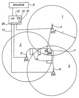
Figure 1 shows a schematic diagram of three radio 'coverage
areas of a cellular telecommunications system in which the
embodiments of the invention can be implemented;
CA 02393046 2005-05-11
- 4b -
Figure 2 shows two radio coverage areas provided by sector
antennas;
s Figure 3 illustrates one possible functional diagram for a
location server; and
Figure 4 shows a partially sectioned view of a mobile
station apparatus embodying the invention..
to
DESCRIPTION OF THE PREFERRED EMBODIMENTS
Reference will first be made to Figure 1 in which three
base stations provide omnidirectional radio coverage
is areas 1, 2 and 3 of a telecommunications network. It
CA 02393046 2002-05-30
WO 01/41468 5 PCT/EP00/12192
is noted that even though the exemplifying telecommunications network shown
and
described in more detail in the following uses the terminology of a GSM
(Global
System for Mobile communications) public land mobile network (PLMN), it should
be
appreciated that the proposed solution can be used in any system providing
communications between a transmitting station and a receiving station. It
should also
be appreciated that even though Figure 1 shows three base station coverage
areas,
the invention can be implemented using one, two or more than three coverage
areas.
The coverage areas 1, 2 and 3 can also be, instead of base station coverage
areas,
three cell coverage areas of the mobile telecommunications network, wherein
the
coverage area of one cell can include more than one base station. It is also
possible
to group cells such that one coverage area comprises more than one cell (For
example, an URA (UMTS Terrestrial Radio Access Network Registration Area)
consists of a group of cells).
Figure 2 shows two radio coverage areas 16 and 17 which consist of sectors of
base
stations 14 and 15 provided with directional or sector antennas. The base
stations
may use e.g. three 120° directional antennas whereby three radio
coverage areas are
provided, or four 90° directional antennas providing four radio
coverage areas and so
on, or any combinations of different radio coverage beam widths.
In Figure 1 each radio coverage area 1, 2 and 3 is served by the respective
base
transceiver station (BTS) 4, 5 and 6. More particularly, each base transceiver
station
BTS is arranged to transmit signals to and receive signals from the mobile
station
(MS) 7. Likewise, the mobile station 7 is able to transmit signals to and
receive
signals from the respective base transceiver station. The mobile station 7
accomplishes this via wireless communication with the base stations. Typically
a
number of mobile stations will be in communication with each base station
although
only one mobile station is shown in Figure 1 for clarity. Each of the base
stations is
connected to a respective network controller (not shown), which in the
exemplifying
GSM system is a Mobile Services Switching Center (MSC). It is noted that more
than
one base station can be connected to each controller. Typically more than one
controller is also provided in a network. The controller is connected to other
elements
of the network via a suitable linking or gateway apparatus (not shown), such
as
CA 02393046 2002-05-30
WO 01/41468 6 PCT/EP00/12192
Gateway Mobile Switching Center (GMSC) or a serving GPRS Support Node
(SGSN).
The mobile station 7 is able to move from one coverage area to another
coverage
area. The location of the mobile station 7 may thus vary in time as the mobile
station
is free to move from one location (base station coverage area or cell coverage
area)
to another location (to another coverage area) and also within one coverage
area.
Figure 1 also shows a Location Services (LCS) node 12 providing Location (LC)
services for different applications or clients 8 who are entitled to receive
at least some
degree of information concerning the location (or location history) of a
mobile station.
Figure 3 illustrates in more detail one proposal according to ETSI (European
telecommunications Standards Institute) technical specification "Location
Services"
(T1 P1.5/99-048r4) for the functional diagram of the location server 12. In
general
terms, the LCS functionality can be defined as a feature capable of providing
information concerning the location of the MS, and more particularly, the
location
defined on the basis of the position of the mobile station relative to the
base stations)
of the mobile telecommunications network.
The location server node 12 is arranged to receive, by receiving means 30,
predefined information concerning the location of the mobile station 7 and to
process
this information and/or some other predefined parameters and/or to compute by
processor means 31 appropriate calculations for determining and outputting the
geographical location of the given mobile station 7. The location server node
12 may
also comprise a register or database 13 for storing radio coverage area
specific data.
This radio coverage area specific data can be alternatively stored in the base
station
itself or in the controller controlling the base station, from where it is
transmitted to the
location server node 12 for the calculations. The data is received from the
telecommunications system by receiving means 30.
3O
Even though not shown in detail, the location server node 12 can be connected
by
means of an appropriate interface to the network controllers (omitted from
Figure 1 for
clarity but previously discussed) controlling the base stations signalling
with the MS 7.
CA 02393046 2002-05-30
WO 01/41468 7 PCT/EP00/12192
It is also noted that even though the location server node 12 can be a
separate node
from a network controller, it could also be a part or an internal component or
functionality of a controller, or gateway controller or any other element of
the
telecommunications system.
The determination of the location of a mobile station can be based on
measurements
of at least one feature of the received radio signal. A feature which can be
used in this
is the time of arrival of the radio signal sent by the mobile station 7 at the
base
stations 4, 5 and 6. The travel time of the received signal at any particular
base
station is related to the distance travelled given by formula:
R=cT,
wherein
R = mobile to base station distance (range)
c = the speed of light, and
T = the travel time of the radio signal.
The location information can also be based on measurements made at the
receiving
station to determine the signal strength, signal to noise ratio or any other
such feature
of the received signal from which it is possible to determine the distance
between the
transmitting station and the receiving station. It is noted that the
measurement of the
feature of the radio signal can be accomplished in the uplink and/or in the
downlink,
i.e. at the base station end or at the mobile station end or both. In case the
mobile
station is used for the measurements of the signal, it can use the radio
network for
sending the measurement results to an appropriate network element. The
necessary
location calculations and determinations based on various collected/defined
data can
be accomplished at the station (base station or the mobile station) or at an
appropriate network element having an access to all required data.
In the situation illustrated by the three circles in Figure 1 or two sectors
18 and 19 of a
circle in Figure 2 each distance measurement would generate a circle or a
sector of a
circle, respectively, centred at the measuring base station and having a
radius r equal
to the transmitting mobile station to receiving base station distance. In the
absence of
CA 02393046 2002-05-30
WO 01/41468 8 PCT/EP00/12192
any measurement error, the intersection of the three circles of Figure 1 and
the
intersection of the two circles of Figure 2 would determine the accurate
location of the
mobile station 7.
Alternatively or additionally, the geographical location is obtained from a
reliable
external source, e.g. from the well known GPS (Global Positioning System). The
GPS
system is a satellite based system used in military and civil applications
where
accurate positioning is required, e.g. for the purposes of navigation. More
accurate
location information can be obtained through a differential GPS. In addition
to the
GPS, any other similar system capable of providing reliable location
information to the
can be used for this.
The mobile station or the like 20 comprises an antenna 24 for receiving the
location
signals from the GPS satellites or similar system. These signals are used by
the
mobile station 20 to determine the current position of the mobile station 20
in a known
manner. This determination can be accomplished by a processor 23.
According to one alternative the user of the mobile station 20 inputs manually
precise
location coordinates (e.g. in altitudes and latitudes, or by using street
names or similar
established address information), e.g. by means of keys 26, a voice
recognition
device, or similar input interface.
The mobile station 20 of Figure 4 is provided with another antenna 22 for
transmitting
radio signals to and/or receiving radio signals from the base station BTS
under
examination. The mobile station can interface with the location server node 12
of
figure 1 in several alternative manners. Since it is capable of establishing a
radio
communication with the base station, the mobile station may also use this
radio
interface for transmitting any messages and information to the location server
or any
other appropriate network element. The interface can also be a specific
infrared or
short range radio connection (such as a "bluetooth" connection) or a fixed
connection
using e.g. appropriate plugs and sockets or cabling between the mobile station
20
and the location server. The mobile station also comprises a display 28.
CA 02393046 2002-05-30
WO 01/41468 9 PCT/EP00/12192
It should be appreciated that any other suitable technique for determining the
position
of the mobile station can be used as an alternative to the methods described
previously. Method using Doppler shift techniques or time difference of
arrival may be
used. In some embodiments of the present invention, more than one method can
be
used. The location can be derived by the mobile station itself or by any of
the network
components. In either case, it should be ensured that the mobile station or
the
network element has the required information to determine the position of the
mobile
station. As will be discussed later, different techniques for calculating the
position of
the mobile station may be used at different times.
Figure 3 schematically shows the location service model in which a LCS client
8 is
arranged to request location information for one or more certain target mobile
stations
from the LCS server node 12. The LCS server node 12 obtains positioning
information obtained using one or more of the techniques discussed previously
or any
15 other suitable technique. This information is provided to the LCS Client 8.
The
particular requirements and characteristics of a LCS Client 8 are known to the
LCS
server 12 by its LCS client subscription profile. The particular LCS-related
restrictions
associated with each target mobile station are detailed in the target mobile
station
subscription profile. The location service feature permits the location of a
target
20 mobile station to be determined at any time whilst the MS is attached.
The LCS client 8 is a logical functional entity that makes a request to the
LCS server
node 12 for the location information of one or more target mobile stations.
The LCS
client 8 may reside in any entity (including a mobile station) within the PLMN
or in an
entity external to the PLMN.
The LCS server node 12 consists of a number of location service components and
bearers needed to serve the LCS clients 8. The LCS server node 12 provides a
platform which will enable the support of location based services in parallel
with other
telecommunication services such as speech, data, messaging, other
teleservices,
user applications and supplementary services. The LCS server node 12 responds
to a
location request from a properly authorized LCS client with location
information for the
CA 02393046 2002-05-30
WO 01/41468 10 PCT/EP00/12192
target mobile stations specified by the LCS client 8 if considerations of
target mobile
station privacy are satisfied.
It shall be possible for the location determining process to make use of
several
sources of information in determining the location. Propagation and deolovment
conditions may limit the number or quality of measurements or additional
measurements may be possible. Some mobile stations may also have additional
(independent) sources of position information of the type discussed earlier.
The LCS
shall be capable of making use of the restricted or the extra information as
appropriate for the service being requested.
The LCS Server 12 may provide the client 8, on request, the current or most
recent
geographic location (if available) of the target mobile station or, if the
location fails, an
error indication and optionally the reason for the failure.
The following are examples of possible clients. Clients broadcasting location
related
information to the mobile stations in a particular geographic area - e.g. on
weather,
traffic, hotels, restaurants; or the like. Clients recording anonymous
location
information (i.e. without any MS identifiers) - e.g. for traffic engineering
and statistical
purposes. Clients enhancing or supporting any supplementary service, IN
(intelligent
network) service, bearer service or teleservice subscribed to by the target MS
subscriber. These are only examples and any other suitable clients may use the
location service node. This service can of course be used to determine the
location of
a mobile station when it makes an emergency call.
The LCS Server 12 shall enable a network operator to charge LCS clients 8 for
the
LCS features that the network operator provides.
It may be possible for the LCS client 8 to specify or negotiate a (minimum)
level of
quality, such as accuracy, in a station location information request.
Different
applications demand different levels of positioning accuracy and other
positioning
performance parameters, so the levels of performance should be classified
according
to the type of applications. The quality of location information can involve
parameters
CA 02393046 2002-05-30
WO 01/41468 11 PCT/EP00/12192
like accuracy, update frequency, time stamp, time-to-first-fix, reliability,
continuity, etc
The quality of the generated location information can exceed the required
level. In
case location information is not available to the required quality level , the
request can
either be denied and the service execution terminated, or the user accepts the
lower
quality information. The quality level requirement of each service
(application) could
be set both by the subscriber and the service provider.
It may be possible to select the repetition rate of the location information
update. The
reports may be distributed to different clients at different rates. It may be
possible to
identify and report when the user's terminal enters or leaves a specified
geographic
area.
In one embodiment of the present invention, the classes are specified for the
accuracy of the positioning information, with estimated probability of
correctness.
Every measurement will usually have a margin of error associated therewith.
The
classes should in preferred embodiments of the present invention take into
account
for what purpose the positioning information is required. The selection of the
class
can be determined by each client or by each mobile station. The class selected
can
also take into account the type of service to be provided by the client.
One benefit is for the user to define how accurate the location information is
which is
made available to different types of LCS clients 8. In one embodiment a
logarithmic
scale could be used, according to which the accuracy is for 90% of cases
within.
(10cm-1 m No accuracy class)
1 m- 1 Om Accuracy class A
10m-100m Accuracy class B
1 OOm - 1 km Accuracy class C
1 km-1 Okm Accuracy class D
10km-100km Accuracy class E
"Not defined" - Accuracy class X
CA 02393046 2002-05-30
WO 01/41468 12 PCT/EP00/12192
The US regulations require that when an emergency call is made that the
location of
the mobile station be known to an accuracy of 50 m. This would fall into class
B. As
an alternative class B can be split in two (or even more) classes: 10m-50m
Accuracy
class B1 and 50m-100m Accuracy class B2. Alternatively or additionally, any
other
class can be split into two or more subclasses.
Class B could be used to identify that the user is in a given building so a
service
application can inform the user about the companies situated in this building
or e.g.
commercial services available in this building or area close by. Class D could
be used
to identify users in a given town and class E to identify users in a given
county or
region.
Another way to define the accuracy classes may be (for 90% of the cases):
Class A: best achievable accuracy for the UE being positioned (whatever that
may
be)
Class B: small area, township, city block, around 1 km
Class C: somewhat bigger area, town, around 10km
Class D: big area, region, around 100 km
Class E: coverage area of the visited PLMN in question
Class F: no position information to be given
Class L: location area
Class R: routing area
Class O: cell coverage area
Class P: PLMN area
Class X: not defined
One main use of the accuracy classes is to enable the user to define wanted
privacy
levels. This means that the subscriber can indicate how accurate position
information
different LCS clients may receive.
Different LCS client types are defined, so that the user can then define his
LCS
privacy profile for example as follows:
CA 02393046 2002-05-30
WO 01/41468 13 PCT/EP00/12192
"LCS Client of type Emergency center is allowed to get class A LCS
information"
"LCS client of general Internet server type can get class B LCS information in
general
but class A only after asking me"
"LCS client type "family members" can get LCS information of class A"
"LCS client type "my company" can get LCS information of class ?"
Another possible use of the accuracy classes is to enable the operator to
define
location service tariffs for the client or the user: "Class A LCS accuracy
will cost you x
Euro every time when network is involved, Class B y Euro, class C is free of
charge",
etc.
In summary embodiments of the present invention make use of the feature that
the
geographical location of a station can be determined in a communications
network
with varying accuracy. The user of the station, or the network operator, will
not
automatically agree to communicate the best achievable accuracy of the station
location to any client.
The user of the station is able to restrict the accuracy with which the
location of the
station is communicated to different clients. The user of the station is able
to define
this accuracy differently for different clients (types).
In embodiments of the invention the accuracy of the location information of a
station is
defined with different accuracy classes. Different types of clients are
defined. It is
possible to define what accuracy class is acceptable for the type of client.
This
combination of accuracy class per client type may be defined by the user or by
the
network operator in the target station subscription profile.
In preferred embodiments of the present invention, there is a plurality of
different
methods available for determining the position of the mobile station. The
method for
determining the position of the mobile station will be selected in accordance
with the
accuracy of the class of position information.
It should be appreciated that whilst embodiments of the present invention have
been
described in relation to mobile stations of a mobile telecommunications
system,
CA 02393046 2002-05-30
WO 01/41468 14 PCT/EP00/12192
embodiments of the present invention are applicable to any other suitable type
of user
equipment of other types of systems providing location functionality. These
system
include satellite based communication systems as well as satellite based
location
systems.
The data can be transmitted between the various network element in packet
form. In
alternative embodiments of the invention the data may be sent in any suitable
format.
The embodiment of the present invention has been described in the context of a
TDMA system. This invention is also applicable to any other access techniques
including frequency division multiple access (FDMA) and code division multiple
access (CDMA) as well as any hybrids thereof. It should also be appreciated
that
base stations can sometimes be referred to as node B.
Embodiments of the invention may be used with fixed wireline access network.
Such
networks can determine the approximate location of the terminal and hence its
user
by mapping the access point of the terminal to the network in geographical
coordinates. In this way also the user of the fixed terminal can be offered
services that
are valid and relevant for the geographical location of the user terminal.
Thus
embodiments of the present invention may be used with other communication
systems where the users are connected to the network over fixed wire lines,
since the
geographical location of the access point of the fixed station can be
determined with
varying degree of accuracy.
In additional, the embodiments may also be used with various satellite based
telecommunication systems.
It is also noted herein that while the above describes one exemplifying
embodiment of
the invention, there are several variations and modifications which may be
made to
the disclosed solution without departing from the scope of the present
invention as
defined in the appended claims.