Note : Les descriptions sont présentées dans la langue officielle dans laquelle elles ont été soumises.
CA 02475804 2012-08-01
1
AIRBORNE VECTOR MAGNETIC SURVEYS
Technical Field
This invention concerns an aircraft equipped for airborne vector magnetic
exploration surveys. It also concerns a method of processing vector magnetic
data
collected during a survey flight of the aircraft.
Background Art
Standard airborne magnetic surveys are performed with sensors that measure
the total magnetic intensity (TMI) which is the magnitude of the total
magnetic field
vector. The total field is assumed to comprise the earth's field added to a
local field
dependent on the geology. Survey areas are sufficiently small that the earth's
field may
be assumed constant and so all variations are due to the geology. In practice
one
subtracts the magnitude of the earth's field from the measured values to
obtain the local
field.
Of course, this practice is incorrect because it fails to allow for the fact
that the
magnetic field is a vector field. The simple subtraction of magnitudes is only
correct
when the two vectors (earth field and local field) are parallel. In general,
remanence
and anisotropy mean that parallelism is rarely achieved, however, for local
fields that
are small compared to the earth's field and close to parallel with it, the
simple
subtraction is a reasonable approximation.
In situations where the remanent magnetic field is comparable in size to the
earth's field and in a variety of directions, the assumption is unreliable.
The
breakdown of this assumption will also affect fields derived from the TMI such
as the
reduced-to-pole (RTP) and first vertical derivative (1VD) fields.
Summary of the Invention
In one aspect, the invention provides an aircraft equipped for airborne vector
magnetic exploration surveys, comprising:
a gravity gradiometer including an inertial navigation system having two
rotation sensors;
CA 02475804 2012-08-01
2
three magnetometers orthogonally mounted to measure the components of
the earth's vector magnetic field;
a recording system to record the measurements of the magnetometers and
rotation sensors; where,
measured angular orientations of the aircraft derived from the rotation
sensors of
the gravity gradient instrument are used to orientate the measured components
of
the earth's vector magnetic field, to derive true vector magnetic data from
airborne
surveys, that is vector aero-magnetic (V AM) data.
In such a VAM system, the processing may be done in real time in the aircraft
during a survey flight, or after the flight has taken place, in the
laboratory.
The three magnetometers may be flux-gate magnetometers, each measuring the
component of the earth's vector magnetic field along its axis, so that the
triad is able to
measure all three orthogonal components.
The rotation sensors may conveniently be provided by an inertial navigation
system, such as may form part of an airborne gravity gradiometer. The sensors
may be
gyroscopes which measure heading, bank and elevation.
The attitude of the aircraft may be recorded to a precision which should allow
the magnetic vector components to be corrected to better than 10 nT. This
compares
favourably with uncorrected data, where for instance, in the earth's field of
about
60 000 nT, an orientation change of 6 degrees can produce a magnetic vector
component error of about 10% or 6 000 nT.
In a further aspect the invention is a method of processing data collected
during
an airborne survey described above, comprising the following steps:
collecting data describing the orientation (attitude) of the aircraft using
one or
more rotation sensors (gyroscopes mounted on a gravity gradiometer platform);
collecting vector magnetic field data using a triad of magnetometers
orthogonally mounted (flux-gate) in the aircraft; and
using the aircraft attitude data provided by the rotation sensors to orient
the
magnetometer data; and
then deriving true vector aero-magnetics.
CA 02475804 2012-08-01
2a
The method involves the rotation of the 3 magnetic field components from the
aircraft
reference frame to the earth's reference frame using a program called
vectorMagTilt,
and a heading correction using a program called VectorMagHeadingCorrection.
The
required parameters for the correction are computed using a program called
vectorMagCalibrate on the calibration survey data. The residual noise in the
data after
the heading correction is still high, but the processed VAM data still
provides a useful
adjunct to the TMI data for mapping and interpretation in areas of strong
remanence
(for instance, over strongly magnetised geology such as banded iron
formations).
PCT/AU03/00136
CA 02475804 2004-08-10
31 December 2003
=
3
The method for processing for processing VAM data, may further comprise any
one or more of the steps of:
removing the permanent magnet effect of the aircraft from the magnetic data;
removing the induced magnetic effect of the aircraft from the magnetic data;
and
removing the eddy-current magnetic effect of the aircraft from the magnetic
data.
The formulas for the permanent magnet effect, induced magnetic effect and
eddy-current magnetic effect of the aircraft may be based on Leliak (1961)1.
The technique may first involve ignoring the eddy-current effects and solving
for the factors for the permanent magnet and induced magnetic dipole fields.
The
permanent magnet and induced magnetic fields may then be computed and removed
from the survey data.
The eddy-current factors may then be computed from a high-pass filtered
version of the corrected data. Alternatively, the eddy-current factors may be
derived
line-by-line on the survey data by a regression process.
Furthermore, the data after corrections of permanent magnet, induced magnetic
and eddy-current effects may go through a residual angle effect correction by
regression. The final corrected data are then written to the survey database.
Use of this aspect of the invention provides a significant reduction of the
noise
in the YAM data. Data processing results show excellent performance of the new
technique in noise reduction.
Brief Description of the Drawings
An example of the invention will now be described with reference to the
accompanying drawings, in which:
Fig. 1 is a schematic diagram of an aircraft equipped for an airborne survey.
Fig. 2 is a diagram defining the aircraft-based LTV coordinate system, the
world-based NED coordinate system, and the aircraft attitude variables
(heading angle,
elevation angle and bank angle).
Fig. 3 is a diagram defining vector magnetic components and vector magnetic
attributes of magnetic field M.
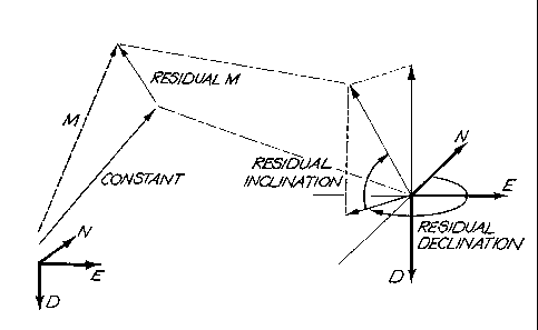
Fig. 4 is a diagram illustrating how the residual magnetic vector is computed
by
1Leliak, P., 1961, Identification and Evaluation of Magnetic-Field Sources of
Magnetic
Airborne Detector Equipped Aircraft: IRE Transactions on Aerospace and
Navigational
Electronics, Spetember, 95-105.
AMENDED SHEET
IPENAU
PCT/AU03/00136
, CA 02475804 2004-08-10
31 December 2003
4
subtracting a constant vector from the observed vector magnetic components.
Whilst
the inclination and the declination of the magnetic vector is typically
confined to a
narrow angular range, the residual magnetic vector typically has inclination
and
declination values covering the entire angular range.
Fig. 5 is three graphs comparing data from vectorMagHeadingCorrection and
data from vectorMagCorrections on a line of survey data (top: North component,
middle: Down component, and bottom: East component).
Fig. 6a is a plot of vectorMagResidualIntensity (VMRI) of data from
vectorMagHeadingCorrection; and
Fig. 6b is a similar plot from vectorMagCorrections.
Best Modes of the Invention
The aircraft 10 carries on board an airborne gravity gradiometer (AGG)
platform 11, a TMI sensor 12 to measure the total magnetic intensity, a triad
of
orthogonally mounted flux-gate magnetometers 13 to provide vector magnetic
field
data, and gyroscopes 14 mounted on the AGG platform 11 to continuously monitor
and
record the orientation (attitude) of the aircraft. The attitude information is
used to
control the platform and for laser scanner processing and self-gradient
corrections of
the AGG data.
The vector magnetic data has three components corresponding to the field
magnitude in each of three orthogonal directions. This allows a wide variety
of
combinations to be formed and mapped. Examples include the components in each
of
the directions North, East and Down; the magnitude of the horizontal
component; the
inclination and declination angles; the TMI and the vector residual magnetic
intensity
(VRMI). The TMI should be the same as that measured by the TMI sensor and the
difference can be taken as a measure of the vector noise. The VRMI is the
magnitude
of the vector formed by-subtracting the earth's vector magneticleld, for
example as
specified by the International Geomagnetic Reference Field (IGRF), from the
measured
vector field. The 'VRMI is thus the intensity of the local field and should
represent the
magnitude of the magnetisation (remanent plus induced) of the local geological
sources.
Computer software is used to process VAM data. One computer program,
vectorMagTilt, converts the YAM data from an LTV (Longitudinal, Transversal,
Vertical) aircraft-based coordinate system to a NED (North, East, Down) world-
based
coordinate system. Another, vectorMagCalibrate, computes the heading
correction
Ai\AEMOGO oc:e.
wpm
PCT/AU03/00136
, CA 02475804 2004-08-10
31 December 2003
coefficients for the NED vector magnetic components. Bank and elevation
correction
may be similarly provided. The coefficients are subsequently to be used by a
third
program, vectorMagHeadingCorrection, to correct the raw NED vector magnetic
component data for aircraft heading effects, and thence to compute relevant
vector
5 magnetic field attributes from the heading-corrected data, such as
horizontal magnetic
component H, inclination INC, and declination DEC. This program also computes
residual magnetic properties by subtraction of a constant vector contribution.
The algorithm reads the LTV magnetic components, along with aircraft attitude
data (heading-angle, elevation-angle, and bank-angle), and converts the LTV
aircraft-
based reading to a NED world coordinate system, through the following
transformation
process:
The vector magnetic flux gate sensors are located in the rear of the aircraft
stinger, and record the magnetic field in three orthogonal directions: L
(longitudinal), T
(transversal), and V (vertical)
The LTV directions are assumed fixed with respect to the aircraft and are
defined as follows:
The LTV directions are orthogonal and form a right-hand coordinate system.
The L direction is pointing towards the aft of the aircraft.
The T direction points M degrees upward towards starboard. M is assumed to
be 45 degrees.
The V direction points M degrees upward towards port. M is assumed to be 45
degrees.
The heading angle H is the aircraft heading in degrees positive clockwise from
North. Fig. 2 depicts a northwesterly heading, and consequently a heading
angle of
approximately ¨45 or +315 degrees.
The elevation angle E is the angle of the aircraft pitch with respect to
horizontal.
The elevation angle is defined as positive up and negative down. Fig. 2
depicts an
upward pitch and thus a positive elevation angle.
The bank angle B is the angle of the aircraft roll with respect to the
starboard
wing. The bank angle is defined as positive for a bank to starboard and
negative for a
bank to port. Fig. 2 depicts a bank to port, and thus a negative bank angle.
The conversion of vector magnetic readings from an aircraft-based LTV
coordinate system to a world-based NED coordinate system is achieved as
follows:
First, the contribution from each of the LTV components to the N component:
AMENDED $1-Itelf
1PVAU
CA 02475804 2004-08-10
WO 03/069373
PCT/AU03/00136
6
The L component projected onto N is:
cos(H +180)= cos(E) = L = ¨ cos(H) = cos(E) = L
The T component projected onto N is:
cos(H +180). sin(E). cos(90 ¨ (M ¨ B)) = T + sin(H +180) = cos(M ¨B) = T
= ¨ cos(H)' sin(E) = sin(M ¨ B) = T ¨ sin(H) = cos(M ¨ B) = T
The V component projected onto N is:
cos(H +180)= sin(E) = cos(M ¨ B) = V + sin(H +180). cos(90 + (M ¨ B)) = V
= ¨ cos(H) = sin(E) = cos(M ¨ B) = V ¨ sin(H) = (¨sin(M ¨ B)) = V
= ¨ cos(H) = sin(E) = cos(M ¨ B) = V + sin(H) = sin(M ¨ B) = V
Hence the total contribution of the LTV components in the N direction is:
N = ¨cos(H) = (cos(E) = L + sin(E) = [sin(M ¨ B) = T + cos(M ¨ B) = VD
+ sin(H) = {¨ cos(M ¨ B) = T + sin(M ¨ B) = V}
Then, the contribution from each of the LTV components to the E component:
The L component projected onto E is:
cos(H + 90)= cos(E) = L = ¨ sin(H) = cos(E) = L
The T component projected onto E is:
cos(H + 90) = sin(E) = cos(90 ¨ (M ¨ B)) = T + sin(H + 90) = cos(M ¨ B) = T
= ¨ sin(H) = sin(E) = sin(M ¨ B) = T + cos(H). cos(M ¨B) = T
The V component projected onto E is:
cos(H + 90)= sin(E) = cos(M ¨ B) V + sin(H + 90)= cos(90 + (M ¨ B)) = V
= ¨ sin(H) = sin(E). cos(M ¨ B)=V + cos(H). (¨sin(M ¨ B))=V
= ¨sin(H)= sin(E). cos(M ¨ B) = V ¨ cos(H). sin(M ¨ B) = V
CA 02475804 2004-08-10
WO 03/069373
PCT/AU03/00136
7
Hence the total contribution of the LTV components in the E direction is:
E = ¨ sin(H) = {cos(E)= L + sin(E)=[sin(M ¨ B) = T + cos(M ¨ B)=VD
+ cos(H){cos(M ¨ B) = T ¨sin(M ¨ B). V)
Then, the contribution from each of the LTV components to the D component:
The L component projected onto D is:
sin(E) = L
The T component projected onto D is:
¨ cos(E) = sin(M ¨ B) = T
The V component projected onto D is:
¨ cos(E) = cos(M ¨ B) = V
Hence the total contribution of the LTV components in the D direction is:
D = sin(E) = L ¨ cos(E)= [sin(M ¨B) = T + cos(M ¨ B)=V]
This example is based on the assumption that the LTV coordinate system is
perfectly aligned with the aircraft coordinate system. That is, that the L-
axis aligns
perfectly with the aircraft longitudinal axis, and not with the stinger
longitudinal axis.
(The stinger is mounted with a slight positive pitch with respect to aircraft
axis). In
practice, there will often be a small angular displacement between the LTV
coordinate
system defined by the three fluxgates and the aircraft coordinate system
referenced by
the heading, elevation and bank angles. The vectorMagTilt program therefore
includes offset angles to correct for this angular displacement. The offset
angles will
vary between aircraft and vectorMagTilt allows for their adjustment as
required.
vectorMagCalibrate is used on vector magnetic calibration flights, which are
performed at the start of each AGG campaign. The calibration flight consists
of eight
flight lines flown at high altitude (preferably more than 3000 ft above the
ground). The
lines are all flown at the same altitude. The lines are flown in the eight
headings 0 ,
45 , 90 , 135 , 180 , 225 , 270 , and 315 . The lines should each be at least
3 km long
and they should all intersect at the same point, roughly at the halfway mark
for each
CA 02475804 2004-08-10
WO 03/069373 PCT/AU03/00136
8
line. The survey essentially forms a star or a pizza with 4 pair-wise parallel
flight lines
(for example at headings 00 and 180 , 45 and 225 , 90 and 270 , 135 and
315'). The
heading correction coefficients are output to screen at the end of the program
execution.
The program first determines all the intersections of the calibration lines.
Once
all the intersections have been determined the algorithm determines the
average
position of the intersections, and outputs the statistics on how well the
pilots managed
have all the calibration lines intersect at one central point.
Having determined a central intersection point the program now extracts the
attitude (heading-, elevation-, and bank-angle) and vector magnetic components
(NED)
from the database at the central intersection point for each of the
calibration line.
The extracted data may be used to verify the heading-angle dependency of the
uncorrected NED data, or how well the subsequent sine-function fitting has
performed.
The algorithm now attempts to fit a scaled sine function of the heading angle
to
each of the NED components. The functions to fit are:
NOBS C NJ = sin(head _angle ¨Cõ,,2)+CN,3
EOBS CE,1 = sin(head _angle ¨ CE,2)+ C E,3
DoBs C,,, = sin(head _angle ¨C D,2)+CD,3
Note that currently no corrections are being applied for bank- and elevation-
angle
effects.
Having established the coefficients CN,, , CN,2,C,.3, etc., we can at a later
stage
perform the heading correction as:
N055 NOBS -C N,1 = sin(head _angle
EOBS,COrr E05 C E,1 = sin(head _angle ¨ C52)
D055,C017 DOBS CD,1 = sin(head _angle ¨ CD,2)
Once the algorithm has computed the correction coefficients the estimated main
magnetic field strength, inclination and declination are output for checking
purposes.
The estimated main magnetic field inclination and declination values will
usually be
within 3 degrees of the associated IGRF values for the calibration site
location.
Having determined the correction coefficients the algorithm displays these on
screen. The data is presented in a format that is appropriate for cut-and-
paste insertion
CA 02475804 2004-08-10
WO 03/069373 PCT/AU03/00136
9
into the parameter file for vectorMagHeadingCorrection.
This example does not attempt to incorporate bank-angle or elevation-angle
into
the correction model. It only uses attitude and vector magnetic information
from the
central intersection point, as it is assumed that the magnetic value should
remain
unchanged over this given point irrespective of the aircraft heading.
vectorMagHeadingCorrection is used to process YAM data.
The correction coefficients to be applied in the heading correction process
are
those computed and output by the program vectorMagCalibrate.
The heading correction is achieved by subtracting a scaled, phase-shifted sine
function of the heading angle from the individual NED vector magnetic
components:
NOBS,corr NOBS ¨ C1 = sin(H ¨CN.2)
EOBS,corr ECM'S' ¨ C 5%1' sin(H ¨ CE,2)
DoEs,con. D
¨ oss ¨00,1 = sin(H ¨CD.2)
The correction coefficients Ciõ,, , C,,,, CEI, etc. are output by the program
vectorMagCalibrate to screen, and must be specified in the parameter file for
vectorMagHeadingCorrection. The screen output from vectorMagCalibrate is
presented
in a format that is appropriate for cut-and-paste insertion into the parameter
file for
vectorMagHeadingCorrection.
The algorithm reads the raw NED vector magnetic component data, along with
aircraft attitude data (heading-angle, elevation-angle, and bank-angle), and
corrects the
raw NED vector magnetic component data for aircraft heading effects by
subtracting
the scaled and phase-shifted sine-functions (above).
Having completed the heading correction, vectorMagHeadingCorrection
computes relevant vector magnetic field attributes from the heading-corrected
data,
such as horizontal magnetic component H, inclination INC, and declination DEC.
Fig. 3 depicts the various vector magnetic components and attributes
associated
with a magnetic field M. From Fig. 3 we get that the horizontal magnetic
vector
component H is computed as:
H 1IN2 _______ E2
The magnetic inclination INC is computed as:
CA 02475804 2004-08-10
WO 03/069373 PCT/AU03/00136
INC = taril (-11.
The magnetic declination DEC is computed as:
5 DEC = .
N
In addition to the "standard" vector magnetic attributes
vectorMagHeadingCorrection also computes the residual magnetic attributes by
first
completing a subtraction of a constant vector contribution from the heading
corrected
10 NED vector magnetic components. The option exists to subtract either the
survey-wide
averages of the NED vector magnetic components, or to subtract the NED vector
magnetic components derived from the vector magnetic calibration flight.
Surveys have been flown over a variety of formations. A comparison of the
total magnetic intensity (TMI) data with the intensity of the residual vector
magnetic
(VRME) data showed very similar results for weakly remanent formation but
significantly different results for more strongly remanent formations. This
demonstrated that the vector magnetic results are able to provide improved
data for
prospecting.
There are also a variety of effects which cause varying magnetic fields from
the
aircraft itself In particular, ferro-magnetic parts of the aircraft will have
a magnetic
field induced from the earth's main field which will change as the orientation
of those
parts varies relative to the earth's field; electrical conductors will have
eddy currents
generated leading to the production of secondary fields; and remanently
magnetised
parts of the aircraft, producing constant magnetic field components in the
aircraft-based
LTV coordinate system, will generate changing magnetic fields in the NED
coordinate
system as the aircraft changes orientation.
These particular effects which depend on aircraft orientation can be written
as
functions of the orientation angles heading, bank and elevation provided by
our rotation
sensors. In practice, poor knowledge of the physical properties of each
relevant aircraft
part, limited knowledge of their position and motion and the high complexity
of the
total system may make this impractical. However, it is possible to use linear
regression
of the measured VAM data against the angular variables to estimate the
coefficients of
the linear terms of these functions; vector aero-magnetic compensation.
CA 02475804 2004-08-10
WO 03/069373
PCT/AU03/00136
11
The main steps are:
a) identify the key regressors using data collected on a calibration
flight;
b) estimate the regressor coefficients (the sensitivity of each component
to
each regressor) by standard linear regression; and
c) correct survey
YAM data by subtraction of the effects calculated as the
product of each coefficient against each regressor.
An additional technique is based on the principle of removing the permanent
magnet effect, induced magnetic effect and eddy-current magnetic effect of the
aircraft
from the magnetic data. This technique has been implemented in processing
software
using two computer programs, a modified vectorMagCalibrate program and a new
code
vectorMagCorrections. Only a single program vectorMagCorrections needs to be
run to
process vector magnetic data on a survey. Prior to processing vector magnetic
data, the
processing parameters will need to be computed by vectorMagCalibrate on
calibration
survey data.
The derivation of formulas for removing the permanent magnet effect, induced
magnetic effect and eddy-current magnetic effect of the aircraft is based on
the model
of Leliak (1961) and is given below.
The measured magnetic field M is composed of the earth's field H (including
ore-body effect), the permanent magnet field of the aircraft A, the induced
magnetic
field of the aircraft I, and the eddy-current magnetic field E. Hence
M=H+A+I+E
In the aircraft reference frame, these are three equations at each observation
point for the three magnetic field components,
= + + + (1)
MT HT + AT+ + ET (2)
Mv = Hv + Av + Iv + Ev (3)
At the interception point of the eight calibration lines, the earth's main
field is
known (the IGRF field or that calculated in vectorMagCalibrate) in the earth's
NED
reference frame. Thus, the LTV components HL, HT, and Hv can be calculated by
rotation with the known aircraft attitude information.
CA 02475804 2004-08-10
WO 03/069373 PCT/AU03/00136
12
The permanent magnet field components AL, AT, and Av are constants that are
independent of aircraft attitude.
The L component of the induced magnetic field of the aircraft at the sensor is
IL = HL'LL+ HT.TL + Hv.VL (4)
where LL is the magnetic field in L direction due to induced magnetic dipoles
in the L
direction for an unit inducing field, TL is the magnetic field in L direction
due to
induced magnetic dipoles in the T direction for an unit inducing field, and VL
is the
magnetic field in L direction due to induced magnetic dipoles in the V
direction for an
unit inducing field.
Similarly, the T component of the induced magnetic field of the aircraft at
the
sensor is
IT = HLIT+ FITIT + HvVT (5)
and the V component of the induced magnetic field of the aircraft at the
sensor is
Iv = HLLV+ HTIV + Hv.VV (6)
Here, (LL, TL, VL, LT, TT, VT, LV, TV, VV) are only dependent on the
dimension, shape, and susceptibility of the parts of the aircraft body, but
independent of
the orientation of the aircraft.
The eddy-current magnetic field is produced by eddy currents in the aircraft
body. A change of magnetic flux through a conducting loop will generate a
current
proportional to the time derivative of the flux in the loop. This current will
produce a
secondary magnetic field opposing the change in the magnetic flux. As the
aircraft hull
effectively consists of conducting loops of aluminium, these loops will
experience a
change in magnetic flux as the aircraft changes direction in the earth's
magnetic field.
These current loops will generate a secondary magnetic field measurable as the
eddy-
current field at the sensor. The L component of the eddy-current field can be
written as
E¨ àHL + _________________ = 11 + __ v/ (7)
L at
at at
where 11 is the magnetic field in L direction due to eddy-current magnetic
dipoles in the
L direction for an unit inducing field, ti is the magnetic field in L
direction due to eddy-
CA 02475804 2004-08-10
WO 03/069373
PCT/AU03/00136
13
current magnetic dipoles in the T direction for an unit inducing field, and VL
is the
magnetic field in L direction due to eddy-current magnetic dipoles in the V
direction
for an unit inducing field. Similarly,
al-IL aHr aH,
ET == /t + _____ = it + __ vt (8)
at
at at
aHr all,
Ev = aHL + ______ + __ =vv (9)
at at at
Here, (11, tl, vi, it, tt, vt, lv, tv, vv) are only dependent on the
dimension, shape,
and electrical conductivities of the parts of the aircraft body forming the
conductive
loops, but independent of the orientation of the aircraft.
Substituting equations (4)-(9) into equations (1), (2) and (3), we obtain
__________________________________ HL + AL + HL = LL + H T = TL + H v =VL +
allL = 11 + tl +aH, = V1 = M L (10)
at at at
aH aH,
HT + AT + HL = LT +HT = TT + H v =VT +aH __ = lt + __ tt + ____________ vt =
MT (11)
at at at
T aH,
Hy+Av+HL=LV+HT=TV+11,=V V+aH ____________ =lv+aH __ tv+ _______________
vv=M, (12)
at at at
Using Leliak's (1961) model as encapsulated in equations (10)-(12), we can
solve for the 24 unknowns (AL, AT, AV), (LL, TL, VL, LT, TT, VT, LV, TV, VV) ,
and (11, ti, vi, it, tt, vt, lv, tv, vv) from the calibration survey data as
follows. At the
intersection point of the calibration lines, we can set up the equations (10)-
(12) for each
line. Since there are eight calibration lines, we have a total of 24
equations. In theory
we should be able to solve for the 24 unknowns from these 24 equations.
However,
since the magnitude of eddy-current magnetic field is much smaller than the
permanent
magnetic and induced magnetic fields, direct solutions of equations (10)-(12)
do not
yield good solutions for (11, ti, vi, It, tt, vt, lv, tv, vv). In practice, we
first ignore the
eddy-current terms and solve for the 12 (AL, AT, Av) and (LL, TL, VL, LT, TT,
VT,
LV, TV, VV) factors for the permanent magnet and induced magnetic dipoles. The
permanent magnet and induced magnetic fields are then computed and removed
from
the calibration survey data. The eddy-current factors are computed from high-
pass
filtered versions of the corrected data. All the 24 factors are computed from
a modified
CA 02475804 2012-08-01
14
version of the vectorMagCalibrate program. VectorMagCalibrate also output
corrected
data to the calibration survey database.
All these factors are input parameters to the vectorMagCorrections program. In
the current implementation of vectorMagCorrections, the eddy-current factors
derived
by vectorMagCalibrate are not used. Instead, new eddy-current factors are
derived line-
by-line on the survey data by a regression process. Furthermore, the data
after
corrections of permanent magnet, induced magnetic and eddy-current effects go
through a residual angle effect correction by regression. The final corrected
data are
then written to the survey database.
Fig. 5 shows a comparison of the data from vectorMagHeadingCorrection and
the data from vectorMagCorrections on a line of survey data. A visual
inspection
suggests a noise reduction improvement of a factor between 3 to 10. The
improvement
using the new technique for vector magnetic data processing is obvious.
Fig. 6a and 6b shows a comparison of the vectorMagneticResidualIntensity
(VIVRI) of data from vectorMagHeadingCorrection and vectorMagCorrections. The
VMRI is the magnitude of the residual magnetic vector after subtracting the
vector
IGRF earth field froth the data. The improvement using the new technique for
vector
magnetic data processing is obvious as shown in Fig. 6a and 6b.
It will be appreciated by persons skilled in the art that numerous variations
and/or modifications may be made to the invention as shown in the specific
embodiments without departing from the scope of the invention as broadly
described. The present embodiments are, therefore, to be considered in all
respects as illustrative and not restrictive.