Note : Les descriptions sont présentées dans la langue officielle dans laquelle elles ont été soumises.
CA 02584037 2007-04-05
AIRBORNE ELECTROMAGNETIC SI7RVEY SYSTEM
The present invention relates to an airborne time-
domain electromagnetic survey system for conducting geological
mapping.
BACKGROUND OF THE INVENTION
The advantage of airborne electromagnetic surveying
systems is that a greater amount of surface area can be covered
when conducting geological surveying for mineral exploration. In
conducting airborne electromagnetic surveying, usually an
airborne vehicle is fitted with a transmitter, which can be
mounted on or towed by the airborne vehicle, such as a
helicopter, airplane or other aircraft, for emitting a primary
electromagnetic field for surveying terrain over which the
airborrie vehicle is flying. A receiver then receives and records
a resultant field, corresponding to the interaction of the
primary field with the underlying terrain, and which comprises a
combination of the primary electromagnetic field emitted by the
transmitter as well as a secondary field emanating from the
underlying terrain. This secondary field may then be processed,
after it is received, in order to ascertain the nature and
geological composition of the underlying terrain.
Because the secondary field emanating from the
underlying terrain is generally much smaller in amplitude than
the primary electromagnetic field, the primary electromagnetic
field can overwhelm the receiver and interfere with its ability
to sense the secondary field. Further, such transmitted
electromagnetic fields generally generate eddy currents not only
in the Earth but also in the proximate metallic parts including
those of the system itself and the aircraft body. The secondary
fields of these eddy currents constitute noise, which can
- 1 - 19190P0004CA01
i I I M 1M
CA 02584037 2007-04-05
adversely impact the survey data and generally increase the
difficulty in obtaining reliable geological information from
this data.
One of the most common ways to minimize this noise is
by isolating the receiver as much as possible from the primary
electromagnetic field emitted by the transmitter. Previously,
such isolation was achieved by physically separating the
receiver from the transmitter by as great a distance as
possible. In general, the greater the distance between the
receiver and the transmitter, the smaller the amplitude of the
primary electromagnetic field at the receiver, and, accordingly,
the lesser the interference with the receiver in detecting the
secondary field.
Typically such distances are maintained between the
receiver and the transmitter, by causing the receiver to be
housed in a "bird" towed by the airborne vehicle.
However, separating the transmitter and receiver by
housing the receiver in a bird leads to technical problems, with
the receiver changing position relative to the transmitter, and
detecting much of the primary field from the transmitter.
Another common means is to devise a transmitter loop
structure containing the transmitter, to which is attached the
separate receiver, in a rigid position as far away from the
transmitter as possible, so as to maintain the distance
therebetween as far as possible and the geometry therebetween as
constant as possible.
However, there are a number of technical problems in
designing such systems. First, such systems are generally larger
and demand heavier frame constructions for carrying the
- 2 - 19190P0004CA01
J
CA 02584037 2007-04-05
transmitter and receiver. For example, due to the separation
required between the transmitter and the receiver in the bird,
it is not unusual for such devices to exceed 20 feet in length
and up to several hundred pounds in weight. While such frames
provide a certain amount of rigidity, which can provide less
noise at the receiver, the heavier frame makes transportation of
the bird difficult. The production costs and fuel costs
associated with the manufacturing and use thereof can also be
high.
In attempting to alleviate this problem, some prior
art systems, such as that described in International Patent
Publication No. WO 2004/046761 (Morrison et al), have utilized
light weight support frame constructions, but these have tended
to be overly flexible, as opposed to utilizing a rigid
structure, and are thus susceptible to noise, through vibration
during use.
It would therefore be advantageous to have a rigid
transmitter loop structure for use in an airborne
electromagnetic (EM) surveying system which maximizes the
rigidity of the structure, so as to reduce vibratory noise,
while, at the same time, minimizing the size and weight thereof.
It would be further advantageous to have an
electromagnetic (EM) survey system which is capable of
substantially completely cancelling the primary electromagnetic
field signal emitted by the transmitter, while still measuring
vertical and/or horizontal components of the resulting
electromagnetic field.
- 3 - 19190P0004CA01
1 . YY=.
CA 02584037 2007-04-05
SUMMARY OF THE INVENTION
The present invention provides an improved rigid
transmitter loop structure for use in an airborne
electromagnetic (EM) surveying system, and having a compact
design which maximizes the rigidity of the structure, so as to
reduce noise, while, at the same time, minimizing the size and
weight thereof.
The present invention provides an improved rigid
transmitter loop structure which utilizes dual turn receiver
coils to null out the primary electromagnetic field signal
emitted by the transmitter, while still measuring a vertical
component of the secondary electromagnetic field, and utilizes
helical coils, in close proximity to the transmitter, oriented
and connected to null out the primary electromagnetic field
signal emitted by the transmitter, while still measuring a
horizontal component of the secondary electromagnetic field.
According to a first broad aspect of an embodiment of
the present invention, there is disclosed a rigid transmitter
loop structure for use in an airborne electromagnetic surveying
system and designed for connection to a towing airborne vehicle,
the transmitter loop structure comprising a plurality of
interconnected loop segments adapted to be constructed to form a
rigid closed loop; transmitting means fitted to at least one of
the interconnected loop segments for generating and transmitting
an earthbound primary electromagnetic field effective for
geological surveying; sensing means fitted to at least one of
the interconnected loop segments for receiving and sensing a
vertical component of a secondary resulting electromagnetic
field, the secondary resulting field arising from an interaction
of the primary electromagnetic field with ground bodies that are
- 4 - 19190P0004CA01
I 1 M 1 N
CA 02584037 2007-04-05
traversed by the sensing means, while simultaneously nulling the
primary electromagnetic field; and helical sensing means
positioned in close proximity to the transmitting means, for
receiving and sensing a horizontal electromagnetic field
contained in the secondary resulting field, while simultaneously
nulling the primary electromagnetic field.
According to a second broad aspect of an embodiment of
the present invention, there is disclosed a rigid transmitter
loop structure for use in an airborne electromagnetic surveying
system and designed for connection to a towing airborne vehicle,
the transmitter loop structure comprising a plurality of
interconnected loop segments adapted to be constructed to form a
rigid closed loop, each of the interconnected loop segments
comprising a center portion, a first container connected to an
outside surface of the center portion, a second container
connected to an inside surface of the center portion, and a pair
of flange plates, the flange plates each being secured to
respective end portions of the center portion and the first and
the second container; transmitting means fitted to at least one
of the interconnected loop segments for generating and
transmitting an earthbound primary electromagnetic field
effective for geological surveying; sensing means fitted to at
least one of the interconnected loop segments for receiving and
sensinci a vertical component of a secondary resulting
electromagnetic field, the secondary resulting field arising
from an interaction of the primary electromagnetic field with
ground bodies that are traversed by the sensing means, while
simultaneously nulling the primary electromagnetic field; and
helical sensing means positioned in close proximity to the
transmitting means, for receiving and sensing a horizontal
electromagnetic field contained in the secondary resulting
- 5 - 19190P0004CA01
I I I M IY =
CA 02584037 2007-04-05
field, while simultaneously nulling the primary electromagnetic
field.
According to a third broad aspect of an embodiment of
the present invention, there is disclosed an airborne
electromagnetic survey system for attachment to a towing
airborne vehicle, the system comprising a transmitter loop
structure, the loop structure comprising a plurality of
interconnected loop segments adapted to be
constructed to form a rigid closed loop, each having a center
portion, a first container connected to an outside surface of
the center portion, a second container connected to an inside
surface of the center portion, and a pair of flange plates, the
flange plates each being secured to respective end portions of
the center portion and the first and the second container;
transmitting means fitted to at least one of the interconnected
loop segments for generating and transmitting an earthbound
primary electromagnetic field effective for geological
surveying; sensing means fitted to the interconnected loop
segments for receiving and sensing a vertical component of a
secondary resulting electromagnetic field, the secondary
result_Lng field arising from an interaction of the primary
electromagnetic field with ground bodies that are traversed by
the sensing means, while simultaneously nulling the primary
electromagnetic field; and helical sensing means positioned in
close proximity to the transmitting means, for receiving and
sensing a horizontal electromagnetic field contained of the
secondary resulting field, while simultaneously nulling the
primary electromagnetic field.
BRIEF DESCRIPTION OF THE DRAWINGS
- 6 - 19190P0004CA01
CA 02584037 2007-04-05
The embodiments of the present invention will now be
described by reference to the following figures, in which
identical reference numerals in different figures indicate
identical elements and in which:
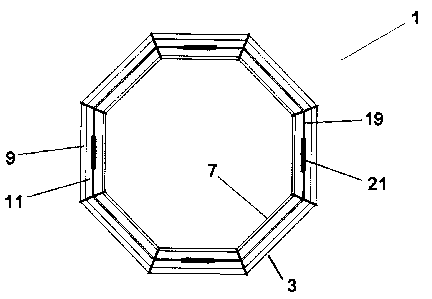
Figure 1 is a top plan view of an embodiment of a loop
structure for use in accordance with an embodiment of
the present invention;
Figure 2 is a top perspective view of one of the loop
sections which comprise the loop structure of Figure
1, in disassembled form; and
Figure 3 illustrates a directional helical coil for
use on the loop section of Figure 2, the loop section
being shown in a partial cut-away view.
DETAILED DESCRIPTION OF THE INVENTION
The invention will be described for the purposes of
illustration only in connection with certain embodiments;
however, it is to be understood that other objects and
advantages of the present invention will be made apparent by the
following description of the drawings according to the present
invention. While a preferred embodiment is disclosed, this is
not intended to be limiting. Rather, the general principles set
forth herein are considered to be merely illustrative of the
scope of the present invention and it is to be further
understood that numerous changes may be made without straying
from the scope of the present invention.
The present invention consists of an airborne
electromagnetic survey system, which includes a transmitting
assembly for conducting geological surveying, and is designed to
- 7 - 19190P0004CA01
il
CA 02584037 2007-04-05
be towed by an airborne vehicle. Preferably, the vehicle is a
helicopter, but those having ordinary skill in the art will
appreciate that other vehicles, such as vertical take-off and
landinq aircraft, could also be used. The transmitting assembly
is separate from the airborne vehicle but is attached thereto by
suitable connection means.
The present invention comprises a rigid frame or loop
structure, and is composed of straight or curved loop segments
constructed of suitable material, on which, or inside which, is
mounted one or more large wire coils for a transmitter, one or
more w_Lre loops for a vertical field receiver coil, and one or
more helical wire coils for horizontal field receiver coils.
The rigid loop structure 1, is formed of a plurality
of interconnected and longitudinally extending loop sections 3,
as can be seen with reference to Figures 1 and 2. In Figure 2,
in a preferred embodiment, it can be seen that each loop section
3 comprises two flange plates 5, an outer tube 9, an inner tube
7 and a shear plate 11. The shear plate 11 acts to significantly
improve the structural integrity of each loop section, without
significant weight increase, and the composite flanges are
bonded to the tubes 7,9 and shear plate 11, in such a way as to
provide a rigid structure. In the preferred embodiment of the
present invention, the flange plates 5 are made of composite
construction, and the tubes 7,9 are made of a rolled composite
construction specifically designed to provide maximal
longitudinal strength. Preferably, the outer tube 9 is the same
size or larger than the inner tube 7.
In constructing each loop section 3, the outer tube 9
is connected to an outside surface of the shear plate 11 and the
inner tube 7 is connected to an inside surface of the shear
- 8 - 19190P0004CA01
I I I YI I IY
CA 02584037 2007-04-05
plate 11. Flange plates 5 are then positioned over respective
end portions of each of the shear plate 11, the inner tube 7 and
the outer tube 9.
Each flange plate 5 has a first tube receiving opening
15 (for receiving the outer tube 9) and a second tube receiving
opening 13 (for receiving the inner tube 7) therein, as well as
a plate receiving slot 17. First tube receiving opening 15 and
second tube receiving opening 13 extend through the entire
surface of the flange plate S. The composite flange plates, when
affixed to these end portions, provide a rigid structure to the
loop structure 1, which rigid structure is not easily
susceptible to vibration noise, even when towed behind a
vehicle.
Preferably, each of the components comprising each
loop section 3 are rigidly bonded together.
The loop structure 1, as noted previously, is formed
by interconnecting an appropriate number of such loop sections
3, each adjacent loop section being, preferably, bolted together
so as to form the rigid loop structure 1. The loop sections 3
which comprise the loop structure may be disassembled and re-
assembled as desired.
When the loop sections are interconnected to form the
loop structure 1, the underlying rigid structure so formed
supports both a transmitter and multiple-axis, null-coupled
receiver coils, as hereinafter described.
In forming the loop structure 1, the flange plates 5
of each loop section are bonded to the loop structure at an
angle to form the desired shape of the loop structure. In a
preferred embodiment, when the loop structure 1 is formed by
- 9 - 19190P0004CA01
II
i i i=
CA 02584037 2007-04-05
interconnecting an appropriate number of loop sections, the loop
structure reflects the shape of a closed polygon of
predetermined size and shape. Those having ordinary skill in
this art will appreciate that the size and shape of the loop
structure 1 may be modified, as appropriate for the particular
application, both in size, curvature (or lack thereof), and
number of segments. Preferably, the interconnected loop sections
3 which comprise the loop structure 1 define a structure having
a 30m diameter.
The loop structure 1 supports a single or multi-turn
transmitter wire, for transmitting a primary electromagnetic
(EM) field. The transmitter wire 19 can be installed on the loop
structure, as can be seen with reference to Figures 1 and 3.
Alternatively, the transmitter wire 19 can be installed inside
the outer tube 9 or the inner tube 7. The current in the
transmitter wire 19 may be driven by bipolar current sources
resembling either a half-sine or a trapezoidal waveform.
In a preferred embodiment, the transmitter electronics
will be housed in a compartment (not shown) attached to any one
(or more) of the loop sections which comprise the loop structure
1. The optimal waveform can thus be adjusted by changing
components in the transmitter electronics. The transmitter
electronics are preferably designed to be modular, so as to
facilitate the easier changing of components to optimize the
characteristics of the transmitter electronics for the waveforms
used.
With respect to the present invention, and with
reference to Figure 3, one or more inner receiver wires 8
composed of one or more turns is attached to the inner tube 7
(or ins,ide the inner tube) of the loop structure 1, the inner
- 10 - 19190P0004CA01
I I YI I li
CA 02584037 2007-04-05
receiver wire 8 sensing vertical electromagnetic fields
contained in the secondary field. In the embodiment depicted in
Figure 3, the inner receiver wires are positioned on the inner
tube. Alternatively, the inner receiver wire 8 could be
positioned on the shear plate 11 of the loop structure.
Preferably, the inner receiver wire 8 is disposed inside the
circumference of the transmitter wire 19, and is positioned in
parallel relationship thereto.
One or more outer receiver wires 6 composed of one or
more turns, and which is also sensitive to vertical
electromagnetic fields contained in the secondary field, is
attached to the outer tube 9 (or inside the outer tube). In the
embodiment depicted in Figure 3, the outer receiver wires 6 are
positioned on the outer tube 9. Alternatively, the outer
receiver wire 6 could be positioned on the shear plate 11 of the
loop structure. Preferably, the outer receiver wire 6 is
disposed outside the circumference of the transmitter wire 19
and is positioned in parallel relationship thereto.
In a preferred embodiment, the configuration,
including the radius of the inner receiver wire and the
configuration, including the radius of the outer receiver wire
are disposed such that the voltage induced in the inner receiver
wire by the electromagnetic field of the transmitter wire 19 is
equal and opposite to the voltage induced in the outer receiver
wire by the electromagnetic field of the transmitter wire 19.
In a first embodiment of the present invention, the
inner and the outer receiver wires are connected together at one
end of the loop structure and outer loop structure, so as to
form a single receiver loop component in one direction with the
radius of the inner wire, and in the other direction with the
- 11 - 19190P0004CA01
CA 02584037 2007-04-05
radius of the outer wire, the respective radii being configured
such that the signal of the primary field of the transmitter is
nulled, but still measures the vertical component of the
secondary electromagnetic field from the earth which is
proportional to the difference of the area of the inner and
outer receiver wires.
In a second embodiment, the signals from both the
inner and the outer receiver wires are measured simultaneously
to sense in each a different strength of a vertical component of
the secondary electromagnetic field, while also measuring
simultaneously equal and opposite strengths of the primary field
emitted from the transmitter. In effecting this measurement, the
secondary field received from the earth is measured as the
difference of the signal measured in the two receiver wires,
which is proportional to the difference in area of the two
receiver wires, and the difference of the signals from the
primary field from the transmitter will be zero.
With reference to Figure 3, a directional helical coil
21 is attached to a loop section of the loop structure, the
directional helical coil being sensitive to a horizontal
component of the electromagnetic field. The directional helical
coil 23. is shown wrapped around the transmitter wire 19,
althouqh the directional helical coil 21 could be positioned
immediately adjacent to or beside the transmitter wire. In
either position, wrapped around the transmitter wire or adjacent
to the transmitter wire, the helical coil is placed in such a
manner as to enter no signal from the primary electromagnetic
field of the transmitter when the loop structure is flat. In
other words, the helical coils are situated to be null-coupled
to the primary electromagnetic field.
- 12 - 19190P00040A01
II
= i 1 14 Y.
CA 02584037 2007-04-05
Helical coils may also be connected in pairs, or in
multiple sections, in such a way as to cancel the primary field
when the transmitter loop distorts in flight, emphasizing the
signal of interest in either the X component (axis horizontal,
in direction of flight), Y component (axis horizontal,
perpen(Jicular to direction of flight), or any horizontal
component, that may be desired.
A directional helical coil 21 could be installed on
any loop section of the loop structure 1, or on every loop
section. In a further embodiment, multiple helical coils can be
installed on any loop section, such that they measure the
electromagnetic field in the same direction, or, if desired, in
opposite directions.
In a still further embodiment, directional helical
coils could be connected in pairs, or in series, in such a way
as to cancel the primary field and to sense a horizontal
component of the electromagnetic field.
In this manner receiver coils of any required
geometric component can be created, including, but not limited
to, sensing an X component (axis horizontal, in direction of
flight) by positioning one or more directional helical coils on
each side of the loop structure, and sensing a Y-component (axis
horizontal, perpendicular to flight) by positioning one or more
directional helical coils on the front and rear of the loop
structure. In this manner, the directional helical coils can be
connected so as to cancel the primary field and enhance the
response of conductors in the underlying terrain. Such
directional helical coils would also cancel out the response of
the transmitted primary electromagnetic field, irrespective of
whether the transmitter coil framework is flat or distorted.
- 13 - 19190P0004CA01
II
x 1
CA 02584037 2007-04-05
Thus, in the present invention the helical coils and the
receiver wires together form a three-component set of sensors
(X, Y and Z ) .
In a preferred embodiment, a single cable from the
airborne vehicle is connected to multiple cables that are
attached to the inventive structure at multiple points around
the circumference of the loop structure. Preferably, these
cables are connected to each flange plate around the loop
structure, though it will also be understood that these cables
can be attached elsewhere on the loop structure so as to evenly
distribute the weight thereabout.
It will be apparent to those skilled in this art that
various modifications and variations may be made to the
embodiinents disclosed herein, consistent with the present
invention, without departing from the spirit and scope of the
present invention.
Other embodiments consistent with the present
invent:ion will become apparent from consideration of the
specification and the practice of the invention disclosed
therein.
Accordingly, the specification and the embodiments are
to be considered exemplary only, with a true scope and spirit of
the invention being disclosed by the following claims.
30
- 14 - 19190P0004CA01
II