Note : Les descriptions sont présentées dans la langue officielle dans laquelle elles ont été soumises.
CA 02585143 2012-02-22
1
RELATIVE MEASURING METHOD AND RELATIVE MEASURING SYSTEM
USING SATELLITE
TECHNICAL FIELD
The present invention relates to a relative
measurement method and relative measurement system for
using radio waves from a plurality of satellites and
detecting displacement by relative measurement.
BACKGROUND ART
As a satellite position measurement technology for
receiving and analyzing radio waves from a plurality of
satellites and detecting a position of a receiver
(hereafter called "mobile station"), a single position
measurement system for measuring position by a solo mobile
station even if the measurement error is large, and a
relative position measurement system for accurately
determining the position of a mobile station using the
correction data from a reference station of which position
is known, are available.
In the relative position measurement system, the
position measurement accuracy is restricted by the linear
distance between receivers, which is the so called "base
length".
For example, in the case of a relative position
measurement system which measures the position
independently using the C/A code of GPS (Global Positioning
System) and corrects the position using the correction data,
the limit of the base length, when the uncertainty of orbit
information of the satellite and the error due to the
ionosphere and atmosphere etc. are approximately the same
for each receiver, is about 100 km or less, and an error
can be offset within this range, so an improvement of
position measurement accuracy in the relative position
CA 02585143 2012-02-22
2
measurement system can be expected.
On the other hand, in the case of a system which
analyzes the base line using a carrier phase so as to
improve the position measurement accuracy, the limit of
the base line is short, about 10 km or less, but the
position measurement accuracy improves dramatically since
a carrier phase, which is sufficiently shorter than the
C/A code, is used [e.g. see the new edition of
GPS-Precision Positioning System by Satellites (issued by
Japan Survey Association)].
An example of a relative measurement system for
measuring a relative displacement of a mobile station
using radio waves from satellites has been disclosed in
Japanese published patent application (2001-281323), and
this can measure the displacement at an accuracy
equivalent to a kinematic system.
DISCLOSURE OF THE INVENTION
In the case of the relative position measurement
system and the relative measurement system mentioned
above, however, relative position measurement or relative
measurement cannot be used in an area in a range where
the base line limit length from any reference station can
be used, and the reference station is not organized, no
matter where the mobile station is located, whether on
land, ocean or in the sky, so position or displacement
cannot be measured accurately.
To solve the above problem, it is an object of the
present invention to provide a relative measurement
method and a relative measurement system using satellites
that can use relative measurement, even for a mobile
station located outside the base length that allows
relative measurement.
CA 02585143 2012-02-22
3
Certain exemplary embodiments can provide a relative
measurement method for forming a relative measurement
network for performing a relative measurement between
predetermined stations by receiving radio waves from
satellites by a reference station and a plurality of
mobile stations, and measuring a reference relative
displacement, which is a relative displacement of each
mobile station viewed from the reference station,
wherein at least one of said mobile stations is disposed
so as to exceed a base line limit length that allows
relative measurement with the reference station, and a
space between predetermined mobile stations is set to be
a base line limit length that allows relative measurement
or set to be less than the base line limit length, the
relative measurement method comprising: a reference
relative displacement computing step of computing a
reference relative displacement between the reference
station and the predetermined mobile station; an
inter-mobile station relative displacement computing step
of computing an inter-mobile station relative
displacement, which is a relative displacement between
said predetermined stations; and a conversion step of
converting the inter-mobile station relative displacement
determined in said inter-mobile station relative
displacement computing step into the reference relative
displacement based on a reference displacement of said
reference station, wherein a relative vector indicating a
displacement of the mobile station from the reference
station is separated into a long cycle fluctuation
component, which does not depend on a fluctuation of the
mobile station, and a short cycle fluctuation component,
which depends on the fluctuation of the mobile station
CA 02585143 2012-02-22
4
and the short cycle fluctuation component is represented
by each x, y and z axis component of a unit vector from
the reference station to the satellite, and carrier
phrases between at least three satellites and each
receiver are measured, and at the same time, this
measurement data is passed through a band pass filter,
and a short cycle phase component corresponding to the
short cycle fluctuation component of the relative vector
is extracted, and at least three inter-receiver single
differences or inter-receiver and inter-satellite double
differences between each receiver and each satellite are
determined for this short cycle phase component, and
based on at least three single differences or double
differences, each axis component of the short cycle
fluctuation component of the relative vector is computed,
and thereby, the relative displacement is measured.
Certain exemplary embodiments can provide a relative
measurement system for forming a relative measurement
network for performing a relative measurement between
predetermined stations by receiving radio waves from
satellites by a reference station and a plurality of
mobile stations, and measuring a reference relative
displacement, which is a relative displacement of each
mobile station viewed from the reference station, wherein
at least one of said mobile stations is disposed so as to
exceed a base line limit length that allows relative
measurement with the reference station, and a space
between predetermined mobile stations is set to be a base
line limit length that allows relative measurement or set
to be less than the base line limit length, a satellite
displacement measurement device for receiving radio waves
from satellites is installed in each of said stations, a
CA 02585143 2012-02-22
4a
radio communication device for transmitting and receiving
data to/from a predetermined station is installed in each
of said stations, and the relative measurement system is
provided with a relative displacement computing section
for computing a relative displacement between said
predetermined stations, and a reference relative
displacement computing section for determining a
reference relative displacement of another mobile station
based on a reference relative displacement of one station
that performs the relative measurement, the relative
displacement measurement device comprising: a short
cycle phase component extraction section for passing a
carrier phase indicating a distance between the satellite
and the mobile station obtained by the satellite
measurement device through a band pass filter, and
extracting a short cycle phase component which is a
time-based fluctuation component; a difference computing
section for determining an inter-receiver single
difference or inter-receiver and inter-satellite double
difference of the short cycle phase component extracted
by the short cycle phase component extraction section;
and a short cycle fluctuation component computing
section for inputting an altitude angle and azimuth of
the satellite obtained by the satellite measurement
device and the inter-receiver single difference or
inter-receiver and inter-satellite double difference
obtained by the difference computing section respectively
to create at least three equations, and solving these
simultaneous equations to compute a short cycle
fluctuation component of a relative vector.
CA 02585143 2012-02-22
4b
It is preferable that a reference relative
displacement computing section in the relative
measurement system is disposed in the reference station,
and the reference relative displacement of the mobile
station is sequentially determined.
It is also preferable that a reference relative
displacement computing section for computing each
reference relative displacement is disposed in each
mobile station in the relative measurement system.
It is also preferable that the relative measurement
in the relative measurement system is performed using a
carrier phase.
According to the relative measurement method and
relative measurement system, a network which
sequentially places mobile stations from a reference
station with a predetermined space so as to be less
than a base line limit length that allows relative
measurement and performs linked relative measurement
is formed, and the relative displacement between each
station is determined, and also the reference relative
displacement of each mobile station is sequentially
determined from upstream to downstream of the network
using the reference relative displacement, which is
a displacement viewed from the reference station
CA 02585143 2007-04-23
of the mobile station of which relative displacement with
the reference station was measured, so the reference
relative displacement of a mobile station which is distant
from the reference station, more than the base line limit
length that allows relative measurement, can be more
accurately determined by the relative measurement via the
mobile station disposed therebetween.
For example, by disposing each mobile station on a
floating body located on a sea surface in a sea area
distant from the reference station on the ground, the
coming of a tsunami can be known at a sea area distant from
the coast line based on the reference relative displacement
of each mobile station, and tsunami related damage can be
minimized.
BRIEF DESCRIPTION OF THE DRAWINGS
Fig. 1 is a perspective view depicting an entire
configuration of the relative measurement system according
to an embodiment of the present invention;
Fig. 2 is a block diagram depicting a general
configuration of a reference station in this relative
measurement system;
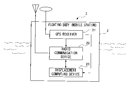
Fig. 3 is a block diagram depicting a general
configuration of a mobile station in the relative
measurement system;
Fig. 4 is a block diagram depicting a general
configuration of a displacement computing device installed
in the mobile station;
Fig. 5 is a flow chart depicting the relative
measurement method in the relative measurement system;
Fig. 6 is a block diagram depicting the general
configuration of the displacement measurement device in the
relative measurement system;
Fig. 7 is a block diagram depicting a general
configuration of the reference station according to a
CA 02585143 2007-04-23
6
variant form of the relative measurement system; and
Fig. 8 is a block diagram depicting a general
configuration of the position measurement computing device
installed in the reference station according to a variant
form of the relative measurement system.
BEST MODE FOR CARRYING OUT THE INVENTION
A relative measurement system and relative measurement
method using satellites according to the present invention
will now be described.
In the present embodiment, a case of measuring
relative displacement viewed from a reference station of a
floating body, which is moored on a sea surface for
detecting the displacement of the sea surface (hereafter
called "reference relative displacement") as a measurement
target, using radio waves and signals from GPS (Global
Positioning System) satellites, which is one measurement
system that uses satellites, will be described.
[Embodiment]
The relative measurement system and relative
measurement method using satellites according to the
present embodiment will now be described with reference to
Fig. 1 to Fig. 6.
This relative measurement system comprises a reference
station 1 fixed on a land of which the absolute three-
dimensional position is known, and a plurality of mobile
stations 3 installed on a plurality of floating bodies
(buoy) 2 sequentially moored on a sea surface with a
predetermined space from the center of the reference
station 1 to offshore in a sea area for detecting the
displacement of sea level viewed from the reference station
1, as shown in Fig. 1, and each of the stations 1 and 3 has
a function for determining a relative displacement of each
mobile station 3 (called "reference relative displacement"
CA 02585143 2007-04-23
7
in the case of relative measurement of the reference
station, and called "inter-mobile station relative
displacement" in the case of measurement between mobile
stations), using an after-mentioned precision fluctuation
measurement system (which uses a carrier phase, hereafter
called "KVD system") receiving radio waves from GPS
satellites 4.
For each mobile station 3, it is assumed that one
closest to the reference station 1 is called the "first
mobile station 3A", and the one closer to the reference
station 1 next is sequentially called the "second mobile
station 3B, third mobile station 3C, . . .", and the one
most distant from the reference station 1 is called the
"nth mobile station 3Z".
As mentioned above, each station is disposed with a
predetermined space, and, for example, the spaces between
the reference station 1 and the first mobile station 3A,
between the first mobile station 3A and the second mobile
station 3B, between the second mobile station 3B and the
third mobile station 3C . . . and between the n-lth mobile
station 3Y and the nth mobile station 3Z are set to be the
base length which allows measurement in a KVD system
(hereafter called "base line limit length", which is 10 km,
for example) or less, and a relative measurement network is
formed among the stations with the reference station to
perform the relative measurement upstream, and at least the
mobile station 3, most distant from the reference station 1,
is installed on a floating body 2 at a position which
exceeds the base line limit length from the reference
station 1. Certainly the space between each station may be
a same length or different length, as long as it is the
base line limit length which allows measurement in a KVD
system or less.
As shown in Fig. 2, the reference station 1 comprises
a GPS receiver (an example of a satellite measurement
CA 02585143 2007-04-23
8
device) 11 for receiving radio waves from the GPS satellite
4 via the antenna lla and measuring the satellite data for
measurement, and a radio communication device (further
comprises a transmitter and receiver) 12 which
transmits/receives various data, including at least the
satellite data for measurement, measured by the GPS
receiver 11, with another mobile station 3.
As shown in Fig. 3, each mobile station 3 comprises a
GPS receiver (an example of a satellite measurement device)
21 for receiving radio waves from the GPS satellite 4 and
measuring the satellite data for measurement, a radio
communication device (further comprises a transmitter 22a
and receiver 22b, as shown in Fig. 4) 22 which
transmits/receives data with other stations 1 and 3, and a
displacement computing device 23 for receiving data from
the other stations 1 and 3 and performing relative
measurement using a KVD system based on the data of the
same time in the local station, that is, determining
relative displacement of another station from one station.
Now the displacement computing device 23 installed in
the mobile station 3 will be described in detail.
As shown in Fig. 4, the displacement computing device
23 comprises a data storage section 31 for storing
satellite data for measurement measured by the GPS receiver
21 (including a carrier phase value, distance between
satellite and antenna of the receiver (pseudo-distance),
orbit information of the satellite, and time series data
(GPS time) used for the satellite measurement system), a
relative displacement computing section 32 for inputting
the satellite data for measurement obtained in the GPS
receiver 21, satellite data for measurement from the
reference station 1 or previous mobile station (mobile
station closer to the reference station in the network,
hereafter also called "previous station") 3, and reference
relative displacement of the previous station, via the
CA 02585143 2007-04-23
9
receiver 22b and computing the relative displacement from
the previous station using the KVD system, a reference
relative displacement computing section 33 for inputting
the relative displacement determined by the relative
displacement computing section 32 and the reference
relative displacement of the previous station and computing
the reference relative displacement of the mobile station 3,
and a transmission data creation section 34 for inputting
the satellite data for measurement of the mobile station 3
stored in the data storage section 31, that is, of the
local station, and the reference relative displacement
determined by the reference relative displacement computing
section 33, and creating the transmission data to be sent
to the next mobile station 3. Certainly the transmission
data created by the transmission data creation section 34
is sent to the next mobile station 3 via the transmitter
22a. Among the satellite data for measurement, the orbit
information is received by the two stations which perform
relative measurement respectively, so if the data is
obtained only by the GPS receiver 21 of one station, the
data may be sent to the other station and used.
Now a method for determining the displacement of a sea
level by determining a relative displacement between each
station in this relative measurement system and measuring
the reference relative displacement of each mobile station
will be described with reference to the flow chart in Fig.
S.
First the satellite data for measurement of the
reference station 1 on the land and the reference
displacement thereof ("0" if there is no fluctuation, as in
the case where the reference station and ground are
secured) are sent to the first mobile station 3A on the sea
surface (step 1).
Then in the first mobile station 3, the relative
displacement viewed from the reference station is
CA 02585143 2007-04-23
determined between the reference station 1 and the first
mobile station 3A using the relative measurement based on
the KVD system (step 2: reference relative displacement
computing step).
Then the reference relative displacement of the first
mobile station 3A is determined using the reference
displacement of the reference station 1 (step 3).
Then the reference relative displacement of the first
mobile station 3A and the satellite data for measurement
are sent to the second mobile station 3B.
Then in the second mobile station 3B, the relative
measurement based on the KVD system is performed between
the first mobile station 3A and second mobile station 3B
using the satellite data for measurement, and inter-mobile
station relative displacement of the second mobile station
3B viewed from the first mobile station 3A is determined
(step 5: inter-mobile station relative displacement
computing step).
Then the reference relative displacement of the first
mobile station 3A is subtracted from the inter-mobile
station relative displacement determined in step 5, and the
reference relative displacement of the second mobile
station 3B is determined (step 6: conversion step).
When the reference relative displacement of the second
mobile station 3B is determined, the above mentioned steps
4 to 6 are repeated, and the reference relative
displacement of the third mobile station 3C is determined,
and this procedure is repeated until the reference relative
displacement of the nth mobile station 3Z, which is most
distant from the reference station is determined. In this
repeating section (steps 4 to 6), the previous station is
indicated as (i-1), and the mobile station, for which
reference relative displacement is determined based on the
relative measurement, is indicated as (i).
Therefore once the reference relative displacement of
CA 02585143 2007-04-23
11
each mobile station 3 is determined, this means that the
displacement of the floating body 2, that is, the
displacement of the sea level at every predetermined cycle,
is measured, and the water level fluctuation of the sea
surface can be accurately measured, and by removing the
wave component and the tidal component from the
displacement of the sea level, a tsunami caused by an
earthquake, for example, can be accurately measured.
In brief, the relative measurement method of the
present invention is a measurement method for forming a
relative measurement network for receiving radio waves from
satellites by a reference station and a plurality of mobile
stations, and performing relative measurement between
predetermined stations, and measuring a reference relative
displacement, which is a relative displacement of each
mobile station viewed from the reference station, wherein
at least one of the mobile stations is disposed so as to
exceed a base line limit length which allows relative
measurement with the reference station, and a space between
predetermined mobile stations is set to be the base line
limit length which allows the relative measurement or less,
and this measurement method has a reference relative
displacement computing step for computing a reference
relative displacement between the reference station and a
predetermined mobile station, an inter-mobile station
relative displacement computing step for computing an
inter-mobile station relative displacement, which is a
relative displacement between the predetermined stations,
and a conversion step for converting the inter-mobile
station relative displacement determined in the inter-
mobile station relative displacement computing step to the
reference relative displacement based on the relative
displacement of the reference station.
In this way, the reference station 1 is disposed on
land, and the mobile stations 3 are sequentially disposed
CA 02585143 2007-04-23
12
on the sea surface from the reference station 1 with a
predetermined space, so as to be the base line limit length
which allows relative measurement based on the KVD system
or less, and the relative displacement between each station
is determined based on the KVD system, and the reference
relative displacement of each mobile station with respect
to the reference station is determined using this relative
displacement, so the reference relative displacement of a
mobile station 3, which is distant from the reference
station 1 more than the base line limit length which allows
relative measurement, can be accurately determined via the
mobile stations 3 disposed therebetween based on the KVD
system.
Therefore by disposing each mobile station on a
floating body on the sea surface in a sea area distant from
the reference station, the existence of a tsunami can be
recognized well before reaching shore, so tsunami related
damage can be minimized.
Now the above mentioned KVD system will be described
briefly.
The KVD system is a precision fluctuation measurement
method, and was disclosed in the above mentioned published
patent application (2001-281323) in Japan.
The measurement accuracy of the KVD system is close to
a real-time kinematic system (hereafter RTK system), so an
overview of the KVD system will be described in comparison
with the RTK system.
In an RTK system, the three-dimensional coordinates of
a measurement target location are determined by determining
the carrier phase at the measurement target location while
referring to the measured value of the carrier phase from
the GPS satellite at a reference point of which latitude,
longitude and altitude have been known, and the fluctuation
component is measured using the time based fluctuation of
the coordinate values. However when the distance between
CA 02585143 2007-04-23
13
the receiver at the measurement target location and the
satellite is determined by the carrier phase, the integer
ambiguity must be determined, and to determine the integer
ambiguity a large volume of calculations must be executed.
In one KVD system, on the other hand, the relative
vector in the reference receiver and the observation
receiver, which is installed in an object, is separated
into a long cycle fluctuation component, which does not
depend on the fluctuation of the object, and a short cycle
fluctuation component, which depends on the fluctuation of
the object, and the short cycle fluctuation component is
represented by each x, y and z axis component of a unit
vector from the reference receiver to the satellite, and
the carrier phases between at lest three GPS satellites and
each receiver are measured, and at the same time, this
measurement data is passed through a band pass filter, and
the short cycle phase component corresponding to the short
cycle fluctuation component of the relative vector is
extracted, and at least three inter-receiver single
differences between each receiver and each GPS satellite
are determined for this short cycle phase component, and
based on at least these three inter-receiver single
differences, each axis component of the short cycle
fluctuation component of the relative vector is computed,
and thereby, displacement of an object is measured.
In another KVD system, instead of the above mentioned
inter-receiver single differences, at least three inter-
receiver and inter-satellite double differences between
each receiver and each GPS satellite are determined for the
extracted short cycle phase components, and based on at
least these three inter-receiver and inter-satellite double
differences, each axis component of the short cycle
fluctuation component of the relative vector is computed,
and displacement of an object is measured.
According to the above KVD methods, focusing only on a
CA 02585143 2007-04-23
14
short cycle fluctuation component directly related to the
fluctuation of the object, each axis component of the short
cycle fluctuation component of the relative vector is
computed based on the inter-receiver single difference of
the short cycle phase component, which is a short cycle
fluctuation component of the carrier phase between both
receivers and the GPS satellite, or based on the inter-
receiver and inter-satellite double difference of the short
cycle phase component, so fluctuation of the object can be
measured without determining the integer ambiguity. The
KVD system, which uses a kinematic system, can measure
several tens of Hertz of vibration of an object, such as
the vibration of a building structure, the vibration of a
machine structure or the fluctuation of sea level.
Now a general configuration of a displacement
measurement device using one KVD system will be described
with reference to Fig. 6.
This displacement measurement device comprises a
satellite angle measurement section 41 for receiving radio
waves transmitted from a GPS satellite, and measuring an
altitude angle Oelv and azimuth Oazm of the satellite from
the data included in the navigation message, a carrier
phase measurement section 42 for measuring a carrier phase
(phase distance) 4, a short cycle phase component
extraction section 43 for passing the carrier phase
measured by the carrier phase measurement section 42
through a band pass filter, and extracting a short cycle
phase component ~S which is a time-based fluctuation
component, a single difference computing section 44 for
determining the inter-receiver single difference A S of the
short cycle phase component ~S extracted by the short cycle
phase component extraction section 43, and a short cycle
fluctuation component computing section 45 for inputting an
altitude angle Oelv and azimuth Oazm from the satellite
angle measurement section 1 and an inter-receiver single
CA 02585143 2007-04-23
difference A4S from the single difference computing section
44 respectively to create at least three equations, and
solving these simultaneous equations to compute the short
cycle fluctuation component ArS of the relative vector Or.
In the description of the above embodiments, the
displacement computing device is disposed in each mobile
station, and the reference relative displacement of each
mobile station is determined, but these reference relative
displacements are transmitted along with a station number
to an observatory (may also be used as a reference station)
on land by a transmitter 22a and centrally controlled there.
On the other hand, the displacement computing device
may be disposed in the reference station, for example, so
that the satellite data for measurement, which each mobile
station measured, is transmitted to and stored in the
reference station, and the reference relative displacement
of each mobile station may be determined by the
displacement computing device of the reference station.
In other words, the inter-mobile station transmission
data in the above mentioned embodiment is transmitted to
the reference station, and the data of each mobile station
is stored in the reference station, and relative
measurement is performed using the stored data using the
same functions as the relative displacement computing
section and reference relative displacement computing
section of the mobile station.
In this case, the reference station 1 comprises
displacement computing device 13, as shown in Fig. 7, and
the displacement computing device 13 further comprises a
data storage section 51 for storing at least satellite data
for measurement from the GPS receiver 11 and satellite data
for measurement received by each mobile station 3 via the
receiver 12b of the radio communication device 12, and a
reference relative displacement computing section 52 for
inputting the satellite data for measurement stored in the
CA 02585143 2007-04-23
16
data storage section 51 and computing the reference
relative displacement of each mobile station 3 with respect
to the reference station 1, as shown in Fig. 8.
In the description of the above embodiment, data
between each station is transmitted/received by the radio
communication device, but if communication by ground waves
cannot be performed due to visual limitations, data can be
transmitted/received via the communication satellite.
Also in the above embodiment, the reference station is
disposed on land, but may be disposed on a floating body on
the sea surface.
Also in the description of the above embodiment, the
reference station is disposed on land and the mobile
stations are disposed on the sea surface so as to measure
waves and tsunami, but if both the reference station and
mobile stations are disposed on land, the relative
measurement system can also be used as a seismograph, for
example.
Also in the above embodiment, satellite measurement
based on GPS was used as an example, but the present
invention can also be applied to a satellite measurement
system (satellite position measurement system) based on the
same principle, or which will appear in the future.
INDUSTRIAL APPLICABILITY
According to the relative measurement method and
relative measurement system of the present invention,
accurate measurement is possible using a relative
measurement based on a KVD system, even for a mobile
station installed at a position exceeding the base line
limit length which allows relative measurement from the
reference station, and by mooring a floating body on which
a mobile station is installed in a sea area quite distant
from land, for example, a tsunami can be measured offshore
and the coming of the tsunami can be forecasted, and the
CA 02585143 2007-04-23
17
damage of the tsunami can be decreased. In some cases, the
relative measurement system can also be used as a
seismograph.