Note : Les descriptions sont présentées dans la langue officielle dans laquelle elles ont été soumises.
CA 02758887 2011-10-14
WO 2010/120637 PCT/US2010/030475
EXTENDING THE COVERAGE OF VSP/CDP IMAGING BY USING FIRST-
ORDER DOWNGOING MULTIPLES
INVENTORS: GULATI, Jitendra S.; ZHAO, Xiaomin;
DOHERTY, Francis D.; and LOU, Min
BACKGROUND OF THE DISCLOSURE
Field of the Disclosure
[0001] This disclosure relates to a method of geophysical prospecting which
improves the subsurface area imaged by Vertical Seismic Profiling (VSP) data.
Specifically, the disclosure uses surface multiples, which have previously
been
regarded as noise, to provide a migrated image of a larger portion of the
subsurface.
Description of the Related Art
[0002] In surface seismic exploration, energy imparted into the earth by a
seismic source reflects and scatters from subsurface geophysical features and
is
recorded by a multiplicity of surface positioned receivers. This process is
repeated
numerous times, using source and receiver configurations which may either form
a
line (2-D acquisition) or cover an area (3-D acquisition). The acquired data
are
processed to produce an image of the reflectors in the subsurface using a
procedure
known as migration. The produced image is then used in prospect evaluation and
development. Prospect evaluation and development specifically includes using
the
determined geometry of subsurface traps to establish the volume of recoverable
reserves, and the drilling of additional exploration, evaluation, and
development wells
based on the image.
[0003] Conventional reflection seismology utilizes surface sources and
receivers to detect reflections from subsurface impedance contrasts. The
obtained
image often suffers in spatial accuracy, resolution, and coherence due to the
long and
complicated travel paths between source, reflector, and receiver.
[0004] In vertical seismic profiling, seismic signals are recorded using
detectors in a wellbore to record the energy generated by the activation of
seismic
sources at the surface. This results in the geometry such as that shown in
FIG. 1 and
is discussed further below. It is well recognized that traditional migration
of upgoing
primary reflections produces a VSP data image of only a very narrow conical
zone
1
CA 02758887 2011-10-14
WO 2010/120637 PCT/US2010/030475
around a borehole with the cone tip centered at the shallowest receiver in a
borehole.
This is schematically illustrated in FIG. 1 wherein exemplary reflected 129a,
129b,
and 129c are shown with an imaging zone denoted by 131.
[0005] The present disclosure is directed towards a method and system for
increasing the coverage obtained in VSP data acquisition.
SUMMARY OF THE DISCLOSURE
[0006] In aspects, the present disclosure is related to methods and
apparatuses
for improving subsurface images using vertical seismic profiling/common depth
point
VSP/CDP data, particularly using surface multiples.
[0007] One embodiment of the present disclosure is a method of evaluating an
earth formation. The method includes: receiving seismic data at at least one
receiver
position responsive to an activation of a seismic source at at least one
source position,
a first portion of the received seismic data resulting from a reflection of
seismic waves
at a free surface; and processing the received seismic data to generate a
first image
using the first portion of the received seismic data, wherein the processing
of the
received seismic data further comprises: building a mirror velocity model
symmetric
to the free surface using a subsurface velocity model, and projecting the at
least one
receiver positing to a virtual position on the mirror velocity model.
[0008] Another embodiment of the present disclosure is a system configured
for evaluating an earth formation. The system includes: a seismic source
configured
to be activated at at least one source position to generate seismic waves into
the earth
formation; a receiver at at least one receiver position configured to receive
seismic
data, a first portion of the received seismic data resulting from a reflection
of seismic
waves at a free surface; and a processor configured to build a mirror velocity
model
symmetric to the free surface using a subsurface velocity model; project the
at least
one receiver position to a virtual position on the mirror velocity model; and
process
the first portion of the received seismic data using the mirror velocity model
and the
virtual position of the at least one receiver to produce a first image.
[0009] Examples of the more important features of the disclosure have been
summarized rather broadly in order that the detailed description thereof that
follows
may be better understood and in order that the contributions they represent to
the art
may be appreciated.
2
CA 02758887 2011-10-14
WO 2010/120637 PCT/US2010/030475
BRIEF DESCRIPTION OF THE DRAWINGS
[0010] The present disclosure is best understood by reference to the attached
figures in which like numerals refer to like elements, and in which:
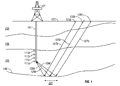
FIG. 1 illustrates the geometry of data acquisition of a walkaway VSP
according to the present disclosure;
FIGs. 2A, 2B shows a primary reflection, first-order downgoing multiple, and
an analogue using the method of virtual image;
FIG. 3 shows the location of the midpoint reflection obtained for a single
source position using VSP/CDP for a primary reflection and a first-order
surface multiple for an exemplary model;
FIG. 4A shows the subsurface coverage obtained using VSP/CDP from
primary reflections only;
FIG. 4B shows the subsurface coverage obtained using VSP/CDP using first-
order multiples;
FIG. 5 shows the velocity model used for modeling results;
FIGs. 6A-C show shot gathers (a) with both upcoming and downgoing waves,
(b) downgoing waves obtained by median filtering, and (c) upcoming waves
obtained by median filtering; and
FIGs. 7A-B show results of VSP/CDP imaging of (a) upcoming primary
reflections, and (b) downgoing first-order multiples.
3
CA 02758887 2011-10-14
WO 2010/120637 PCT/US2010/030475
DETAILED DESCRIPTION
[0011] For the present disclosure, the acquisition geometry of a walkaway
VSP is illustrated in FIG. 1. Shown therein is the surface of the earth 123
with a rig
121 thereon. This may be a drilling rig or it may be a mast rig which conveys
a
wireline into a borehole 101. It could also be a borehole with permanently
installed
seismic sensors. The borehole 101 penetrates layers 103, 105.... Positioned in
the
borehole 101 are seismic sensors denoted by 111a, 111b, 111c, 111d.... Each of
the
sensors may include a hydrophone, a single-component geophone or a multi-
component geophone. Data for a single offset VSP is typically acquired using a
single seismic source such as 125a at the surface (or within a body of water
at the
surface). An exemplary ray path which depicts the propagation of seismic
energy
from the source 125a to a detector 111d is depicted by the ray 127a that is
reflected
from the bottom of layer 105 at the boundary 106 and reaches the receiver 111d
along
the ray path denoted by 129a. Exemplary ray paths 127b and 127c depict the
propagation of seismic energy from sources 125b and 125c, respectively. The
seismic
waves represented by the ray paths may be compressional waves and/or shear
waves.
[0012] In a typical VSP, data resulting from operation of a source at a single
position such as 125a are recorded in each of the receivers 111a, 111b, 111c,
111d...
in the borehole. Analysis of the reflected data can provide information about
the
seismic velocities in the subsurface and the configuration of the layer
boundaries. In
a walkaway VSP, this process is repeated for operation of the source at a
plurality of
source positions such as 125b, 125c.... Acquisition of data from a plurality
of source
positions at a plurality of detectors provides a redundant sampling of the
subsurface
region. Commonly, a processor at a surface or at a remote location (not shown)
is
used to process the data. In offshore acquisition, and airgun is commonly used
as a
source. On land, explosive or vibratory sources may be used.
4
CA 02758887 2011-10-14
WO 2010/120637 PCT/US2010/030475
[0013] It is worth noting that with a VSP survey geometry shown in FIG. 1,
the recorded signals may be responsive primarily to reflectors below the
recording
array, and over a limited portion of the subsurface indicated generally by
131.
[0014] The present disclosure uses, in addition to the reflected signals from
below the recording array, first-order free-surface related multiples. The
first-order
free-surface related multiples are actually those upgoing primary reflections
reflected
once again from the free surface, and then propagating in a downward direction
to the
borehole receivers. FIG. 2A illustrates the ray path corresponding to a
seismic source
201, the upcoming primary reflection 205 and a downgoing first-order surface
multiple 207 from the same reflecting interface as 205 to the receiver 203.
The
equivalent receiver image point is shown by 203' in FIG. 2B.
[0015] FIG. 3 shows the subsurface coverage obtained from primary
reflections 301 into a borehole 305 for an exemplary velocity model. For the
first-
order surface multiples (shown on the opposite side of the borehole for
clarity) it can
be seen that coverage 303 is obtained for a greater distance from the
borehole.
Specifically, what is plotted is the location of a reflection point for a
layered earth
formation at a plurality of depths corresponding to a single source location
310 on the
surface. Using the same model, the insonification that is obtained is shown in
FIG.
4A by 401 for primary reflections only. The insonification using first-order
multiples
is shown in FIG. 4B by 413, 415 and 417. It is worth noting that, using
primaries
only, it is not possible to image the subsurface above the depth of the top of
the
receiver array at 405. It should also be noted that the use of first-order
multiples fills
in a large portion of the subsurface outside the region bounded by 401 that is
not
imaged by the primary reflections.
[0016] FIG. 5 shows a layered velocity model used for illustrating a method
according to one embodiment of the present disclosure. FIG. 6A shows a
synthetic
shot gather with both upcoming and downgoing waves. The source offset is
1450m.
FIG. 6B shows the same shot gather with downgoing waves obtained by median
filtering. The direct arrivals have been muted for imaging purposes. FIG. 6C
shows
the same shot gather with upcoming waves obtained after median filtering.
[0017] Turning now to FIG. 7, the results of imaging of the upcoming
primary reflections are shown in FIG. 7A. The lack of coverage noted in FIG.
4A at
shallow depths and at large offsets is confirmed. To produce a VSP/CDP image
of
the first-order downgoing multiples, a mirror image of the velocity model
above the
CA 02758887 2011-10-14
WO 2010/120637 PCT/US2010/030475
shot surface was created and the receiver locations were assigned at their
mirror
locations. The deconvolved upgoing and the downgoing waves were then used for
VSP/CDP imaging the subsurface by using the same algorithm. The result of
imaging
the downgoing first-order primary reflections is shown in FIG. 7B. The
additional
coverage noted in FIG. 4B at shallow depths and large offsets is confirmed. In
addition, there is a good match between the reflections events in the two
sections at a
number of different levels including those indicated by arrows.
[0018] The VSP/CDP process is a modification of the conventional surface
CDP stacking process in which seismic events are summed along a hyperbola
defined
by:
2
T2 =7~ + z (1),
V'2
where x is the source-receiver offset, To is the normal incidence traveltime
to a
reflector, T is the measured traveltime for the specified source-receiver
offset, and Ve
is an effective (or root-mean-square) velocity.
For the VSP/CDP, the relation is given by:
z
2 + T2-V, (2),
where XS is the source offset from the borehole, V is the velocity, r is the
two-way
vertical time to a reflector, and 2g is the two-way vertical time to a
hypothetical
reflector coincident with the receiver.
[0019] The method of the present disclosure has been described above in
terms of VSP geometry in which sources are at the surface and a receiver may
be at a
downhole location. The method may also be practiced, based on the principle of
reciprocity, by having a downhole seismic source and surface receivers. For
such a
reverse VSP geometry, the free surface reflection would occur before the
reflection at
the subsurface layer, and instead of a virtual receiver, the method would be
based on
constructing a virtual source.
[0020] The inversion and migration methodology described above may be
implemented on a general purpose digital computer. As would be known to those
versed in the art, instructions for the computer reside on a machine readable
memory
device such as ROMs, EPROMs, EAROMs, Flash Memories and Optical disks.
6
CA 02758887 2011-10-14
WO 2010/120637 PCT/US2010/030475
These may be part of the computer or may be linked to the computer by suitable
communication channels, and may be even at a remote location. Similarly,
seismic
data of the type discussed above may be stored on the computer or may be
linked
through suitable communication channels to the computer. The communication
channels may include the Internet, enabling a user to access data from one
remote
location and get the instructions from another remote location to process the
data.
The instructions on the machine readable memory device enable the computer to
access the multicomponent data and process the data according to the method
described above.
[0021] What has been described above is a method of evaluating an earth
formation. The method includes: activating a seismic source at at least one
source
position and generating seismic waves into the earth formation; receiving
seismic data
at at least one receiver position, a first portion of the received seismic
data resulting
from a reflection of seismic waves at a free surface; processing the first
portion of the
received seismic data to produce a first image; and conducting further
operations
based at least in part on the produced first image; wherein processing the
received
seismic data further comprises: building a mirror velocity model symmetric to
the free
surface using a subsurface velocity model, and projecting the at least one
receiver
position to a virtual position on the mirror velocity model.
[0022] The seismic data may further include a reflection of seismic waves
with a portion of the earth below the at least one receiver, and the method
may
include processing the received seismic data to produce a second image using
the
reflection of the seismic waves with the portion of the earth formation below
the at
least one receiver. The at least one source position may include a plurality
of source
positions at or near the free surface. The at least one receiver position may
include a
plurality of positions in a borehole in the earth formation. The processing of
the
received seismic data may include applying a VSP/CDP stacking. The further
operations may include: storing at least one of the processed first image and
second
image on a suitable medium, displaying at least one of the processed first
image and
second image, performing additional prospect evaluation, establishing a volume
of
recoverable reserves, drilling an additional exploration well, drilling an
additional
evaluation well, and/or drilling in additional development well. The at least
one
source position may include a plurality of source positions in a borehole in
the earth
7
CA 02758887 2011-10-14
WO 2010/120637 PCT/US2010/030475
formation. The at least one receiver position may include a plurality of
positions at or
near the free surface.
[0023] Also described above is a system configured for evaluating an earth
formation. The system includes: a seismic source configured to be activated at
at
least one source position to generate seismic waves into the earth formation;
a
receiver at at least one receiver position configured to receive seismic data,
a first
portion of the received seismic data resulting from a reflection of seismic
waves at a
free surface; and a processor configured to build a mirror velocity model
symmetric to
the free surface using a subsurface velocity model; project the at least one
receiver
position to a virtual position on the mirror velocity model; and process the
first
portion of the received seismic data using the mirror velocity model and the
virtual
position of the at least one receiver to produce a first image.
[0024] A portion of the seismic data may include a reflection of seismic waves
with a portion of the earth formation below the at least one receiver and the
processor
may be configured to provide a second image of the earth formation using the
reflection from below the at least one receiver. The at least one source
position
may include a plurality of source positions at or near the free surface. The
at least one
receiver position may include a plurality of positions in a borehole in the
earth
formation. The processor may be configured to process the received seismic
data by
further applying a VSP/CDP stacking. The further operations may include
storing at
least one of the processed first image and the processed second image on a
suitable
medium, displaying at least one of the processed first image and second image,
performing additional prospect evaluation, establishing a volume of
recoverable
reserves, drilling an additional exploration well, drilling an additional
evaluation well,
and/or drilling in additional development well. The source may be an airgun,
an
explosive source, or a vibratory source. The system may include a conveyance
device
configured to convey the receiver into a borehole. The at least one source
position
may include a plurality of source positions in a borehole in the earth
formation. The
at least one receiver position may include a plurality of positions at or near
the free
surface.
[0025] While the foregoing disclosure is directed to the preferred
embodiments of the disclosure, various modifications will be apparent to those
skilled
in the art. It is intended that all such variations within the scope and
spirit of the
appended claims be embraced by the foregoing disclosure.
8