Note : Les descriptions sont présentées dans la langue officielle dans laquelle elles ont été soumises.
CA 02807417 2013-05-10
,
,
METHOD AND SYSTEM FOR MODELING ANOMALOUS DENSITY ZONES IN
GEOPHYSICAL EXPLORATION
[0001]
FIELD OF THE INVENTION
[0002]
The invention relates to the field of geophysical exploration and earth
modeling
and more particularly, to methods and systems for earth modeling using
improved and/or
modified inversion techniques.
BACKGROUND OF THE INVENTION
[0003]
Exploration for oil and/or minerals in subsurface environments has
traditionally
been done with seismic imaging techniques that are now well known in the art.
In some
applications, and particularly where there exists zones of anomalous densities
or salt, seismic
techniques alone fail to provide an adequate image as regions surrounding or
beneath these zones
are not clearly modelled. One particular example of a zone of anomalous
density is a base of
salt, such as that found in the Sudbury Basin in Ontario, Canada. Beneath the
base of salt are
significant deposits of minerals or of oil and gas, and in the case of the
Sudbury basin, most
notably, nickel deposits.as has been shown, for example, in the Gulf of
Mexico. Determining the
shape of the base of salt is important in subsalt exploration. In the absence
of an accurate model
- 1 -
85501-3 (KB/YB)
LEGAL_20790886 1
CA 02807417 2013-02-27
WO 2012/027848 PCT/CA2011/050531
of these anomalous density zones, the model or image of mineral deposits or
petroleum
reservoirs below these zones cannot be determined with a high degree of
confidence. Where
seismic techniques alone fail to provide an adequate image of the base of
salt, gravity response
data can be used to complement the seismic data, by assisting in identifying
the boundary of the
base of salt, or other anomalous density zone.
[0004] As is known, the geologic component of the gravity field produced by
such zones
of anomalous densities, that is the component of interest, is a small fraction
(approximately 2%)
of the total measured gravity field. Therefore, a high level of precision and
accuracy in
measurement is required in order to resolve the geology with a fair degree of
confidence. The
advent of new and ever improving airborne gravity instrumentation, coupled
with large data
storage capacity and high processing speed makes it possible to develop better
resolved
interpretations of the airborne gravity information to thereby result in a
more accurate boundary
model of zones of anomalous density, such as a base of salt.. It has also
become standard
practice in the art to model this gravity or magnetic data using inversion
when complimenting
the seismic, or other base data. The difficulty with relying extensively on
inversion data is that
the density model produced is not unique and can result in poor
interpretations of the geologic
boundary.
[0005] Furthermore, inversion techniques are often complex and require
significant
hardware processing time and resources. This is particularly important when
attempting to
precisely define boundaries of anomalous density zones with greater and
greater precision and
accuracy.
- 2 -
CA 02807417 2013-02-27
WO 2012/027848 PCT/CA2011/050531
[0006] There is therefore a need in the art for a method and system that
allows for more
accurate and precise modelling of subsurface environments, and particularly
those that include
one or more regions of anomalous density zones such as regions of salt and
have a base of salt
below which there may be significant petroleum resources or mineral deposits.
There is a further
need in the art for a method and system that provides for accurate and precise
modelling of
subsurface environments that is less demanding on processing time and hardware
resources than
prior art methods and systems. There is a further need in the art to solve one
or more of the
above-identified problems with the prior art and for an improved method and
system for earth
modelling, and particularly for earth modelling of regions having one or more
anomalous density
zones.
SUMMARY OF THE INVENTION
[0007] According to one embodiment of the invention, there is provided a
method for
modeling a subsurface anomalous density zone including the steps of forming a
density model,
computing a response to the density model, inverting the measured gravity
response to arrive at a
geometric model of the anomalous density zone, and, applying a sharpening
function to
boundary regions of the geometric model to distinguish between the anomalous
density zone and
a surrounding region.
[0008] According to one aspect of the invention, the sharpening function
includes an
iterative inversion function that may include one or more weighting functions
that are reweighted
with each iteration. Preferably, the weighting functions emphasize the density
of the anomalous
density zone and the density of the surrounding region while suppressing
transition densities
- 3 -
CA 02807417 2013-02-27
WO 2012/027848 PCT/CA2011/050531
between the anomalous density zone and the surrounding region.
[0009]
According to another aspect of this embodiment, the sharpening step is carried
out, at least in part, by applying a set of formulae of the form S--((m ¨ mo)Y
+ ; where S is
the sharpening function, iii is a current model, iii is a target body density,
and the remaining
variables are tuning parameters. Preferably, the tuning parameters are
selected to emphasize the
density of the anomalous density zone and the density of the surrounding
region, while
suppressing transition densities between the anomalous density zone and the
surrounding region.
[0010]
Preferably, the various embodiments of the invention are used or otherwise
applied to situations where the subsurface anomalous density zone is a base of
salt and the
surrounding region is a sediment region, such as in subsurface geological or
geophysical
exploration.
[0011]
According to another aspect of the invention, the step of forming a density
model
includes forming a density model using a velocity-density nodal relationship
that preferably
n = a1P-3
results in a layered density model, for example one formed by Gardener's
equation: r P .
[0012]
According to another aspect of the invention, the response being computed is
one
of a gravity response and a magnetic response.
[0013]
Preferably, the step of inverting includes the sub-steps of (a) creating a
measure of
the data misfit (b) creating a measure of a desired model characteristic; and,
(c) minimizing the
model measure subject to the fitting of the data to the desired level. This
may be carried out
- 4 -
CA 02807417 2013-02-27
WO 2012/027848 PCT/CA2011/050531
using the set of formulae.
Given
dohs =g(m)+E
solve
min(m¨mo)'Co' (In ¨m0)
In
suchthat
(dobs
2 ¨ g(m)'\ 2
Z = = ZO
od
where dub is the observed gravity response, s is the unknown error inherent in
the observed
response, m is the density model being recovered, mo is the target model, g( )
is the mathematical
embodiment of the geophysical gravity measurement, Co is the target model
covariance, 5d0 is an
estimate of the true error. The second equation is minimize subject to the
constraint in the third
line.
[0014] According to another aspect of the invention, the step of inverting
comprises a
constrained inversion. Preferably, the constrained inversion includes
constraints of data selected
from the group comprising: response other sources, known boundary data,
seismic
interpretations, bathymetry, and combinations of the above. Such constraints
would provide
auxiliary equations, beyond the third line, to the preceding optimization
problem.
[0015] According to a second embodiment of the invention, there is provided
a non-
transitory computer readable medium having instructions thereon for executing
a computer
- 5 -
CA 02807417 2013-02-27
WO 2012/027848 PCT/CA2011/050531
program that when executed on a computer carries out a method for modeling a
subsurface zone
of anomalous density comprising the steps forming a density model, computing a
response to the
density model, inverting the response to arrive at a geometric model of the
anomalous density
zone, and, applying a sharpening function to boundary regions of the geometric
model to
distinguish between the anomalous density zone and a surrounding region.
[0016] According to the second embodiment, the computer readable medium
may have
any instructions thereon for carrying out any of the method steps as defined
with respect to the
first embodiment.
[0017] Accordingly, it is an object of the invention to mitigate one or
more of the
deficiencies of the prior art as herein identified.
BRIEF DESCRIPTION OF THE DRAWINGS
[0018] The novel features which are believed to be characteristic of the
present
invention, as to its structure, organization, use and method of operation,
together with further
objectives and advantages thereof, will be better understood from the
following drawings in
which a presently preferred embodiment of the invention will now be
illustrated by way of
example. It is expressly understood, however, that the drawings are for the
purpose of
illustration and description only, and are not intended as a definition of the
limits of the
invention. In the accompanying drawings:
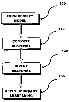
[0019] Figure 1 is a flowchart showing one embodiment of the present
invention.
- 6 -
CA 02807417 2013-02-27
WO 2012/027848 PCT/CA2011/050531
[0020] Figure 2 is a schematic drawing of a representative computer system
that may be
used for carrying out the method of Figure 1.
[0021] Figure 3 shows airborne acquired gravity data with a low pass filter
being applied.
[0022] Figure 4 shows an unconstrained inversion of the gravity data of
Figure 3.
[0023] Figure 5 shows magnetic data superimposed on the gravity data of
Figure 3.
[0024] Figure 6 shows a gravity inversion model obtained by the cooperative
inversion of
the data of Figure 3 and Figure 5.
[0025] Figure 7 shows a representative original gravity model.
[0026] Figure 8 shows a slice taken through the model of Figure 5 at 6000
E.
[0027] Figure 9 shows a first sharpening iteration slice taken through the
model of Figure
at 4400 E.
[0028] Figure 10 shows a second sharpening iteration slice taken through
the model of
Figure 5 at 4400 E.
[0029] Figure 11 shows the resultant iterative weighted gravity inversion
model obtained
in accordance with one example in which the invention of Figure 1 is applied.
DETAILED DESCRIPTION
- 7 -
CA 02807417 2013-02-27
WO 2012/027848 PCT/CA2011/050531
[0030] The invention provides for an improved method and system for
modeling
subsurface regions of the earth, and particularly, subsurface regions having
one or more zones of
anomalous density. The models described throughout this description are
preferably generated
using voxel-based modeling, whereby subsurface regions, including those
encapsulating a zone
of anomalous density are modeled using an array of elements of volume that
constitute a notional
three-dimensional space. The three-dimensional space being modeled is thus
divided into an
array of discrete elements which represent this space. Data acquired from
seismic, gravity and/or
magnetic techniques are all converted into representative voxel data so that
the data may be
combined and manipulated as appropriate to arrive at the best model for a
region of geophysical
exploration. General methods of manipulating voxel data are generally known.
Reference to
datasets, various types of data and manipulations of data throughout this
description are, unless
otherwise noted, made with respect to voxel data or datasets. The invention
contemplates the use
of various other types of data as would be known in the art for creating
geophysical models.
[0031] Various aspects of the invention may be implemented on a computer
system, and
particularly for carrying out the various data manipulations herein described.
One such computer
system is shown in Figure 2 and may generally include a number of physical and
logical
components, including a central processing unit ("CPU"), random access memory
("RAM"), an
input/output ("VO") interface, a network interface, non-volatile storage, and
a local bus enabling
the CPU to communicate with the other components. The CPU executes an
operating system,
and a number of software systems, including those carrying out the method of
the invention.
RAM provides relatively-responsive volatile storage to the CPU. The 1/0
interface allows for
- 8 -
CA 02807417 2013-02-27
WO 2012/027848 PCT/CA2011/050531
input to be received from one or more devices, such as a keyboard, a mouse,
etc., and outputs
information to output devices, such as a display and/or speakers. The network
interface permits
communication with other systems. Non-volatile storage stores the operating
system and
programs, including computer-executable instructions. During operation of the
computer
system, the operating system, the programs and the data may be retrieved from
the non-volatile
storage and placed in RAM to facilitate execution. Furthermore, more than one
computer system
may be used. Additional computer systems may be used to carry out different
steps of the
method herein described.
[0032] As described above, while the invention may be used and applied to
various forms
of subsurface exploration and modeling, the invention is particularly useful
for identifying zones
of anomalous densities and more particularly, for defining the boundaries of
these zones of
anomalous densities. The method of the invention provides for a more accurate
and precise
boundary modeling of such zones using less hardware resources and faster
computation time that
is an improvement over the art.
[0033] Referring now to Figure 1, the invention generally includes a method
for mapping
subsurface regions of the earth including the steps of forming a density model
100, computing
the response 110, such as the gravity response, inverting the response 120,
and applying a
boundary sharpening 130 to obtain a more accurate and precise model of
subsurface region. The
method is particularly useful in obtaining models of regions of anomalous
densities.
- 9 -
CA 02807417 2013-02-27
WO 2012/027848 PCT/CA2011/050531
[0034] In step 100 of Figure 1, a density model of a particular subsuiface
region is
obtained. According to the preferred embodiment, the density model is
calculated using a
velocity density nodal relationship, such as that defined by Gardner's
Equation:
p =al/1,73
[0035] Gardner's Equation defines the bulk density of a volume of space as
defined from
the P-wave velocity obtained from seismic data and empirically derived
constants for a particular
geology. Once a density model of a particular region is derived from this
calculation, where a
zone of anomalous density exists, it will be evident that some zone having a
different density in
the density model exists. However, as in prior art methods, the boundary
between the zone of
anomalous density and the surrounding regions cannot be clearly defined merely
from the
seismic data collected and converted into a model using the equation above.
Furthermore, as is
well known, Gardner's Equation does not fit well with certain compounds,
including salt. This is
particularly problematic where the zone of anomalous density is a base of
salt, as is quite
common in mineral exploration. Accordingly, subsalt regions and regions in the
immediate
vicinity of any base of salt are not clearly delineated from the density model
derived from
Gardner's Equation.
[0036] The resultant density model thus derived is a layered density model
produced
from layered velocities. The earth model will thus comprise a number of voxels
occupying the
space being modeled, each having associated therewith a density.
-10-
CA 02807417 2013-02-27
WO 2012/027848 PCT/CA2011/050531
[0037] As will be appreciated by those skilled in the art, other methods
for obtaining a
density model may be used in step 100 of the invention. Such alternate methods
may include
empirically derived methods and theoretically derived methods and would be
known to a person
skilled in the art. This step provides for a crude density model of a
subsurface region, that may
identify possible anomalous density zones, from which more detailed modeling
may be required
to obtain a more accurate and precise model of the subsurface region.
[0038] According to step 120 of Figure 1, the response of the density
model is then
obtained. In the preferred embodiment, the gravity response is used, but it is
also conceivable
that a magnetic or tensor response can be applied without departing from the
invention. Gravity
response can be computed and/or measured in a number of ways known in the art.
According to
the preferred embodiment, the gravity response is determined from obtained
airborne gravity
information. Such methods and instruments for obtaining this information are
known in the prior
art and are only described in general detail. Generally, all airborne data is
first submitted to the
standard de-spiking, initial time based noise filtering, drift correction and
leveling. After these
steps are applied, gravity data reduction takes place. Specifically inherent
to gravity data
reduction are the latitude effect, free air, Bourguer and terrain corrections,
and earth curvature
corrections. The effects of the Earth's rotation are accounted for in the
tidal and Eotvos
corrections. Furthermore, vertical and horizontal acceleration corrections are
necessary as the
airborne gravity data is obtained from a moving platform. Once the airborne
gravity data is
obtained and all corrections have been made the data is inverted to obtain a
zone model.
- 11 -
CA 02807417 2013-02-27
WO 2012/(127848 PCT/CA2011/050531
[0039] According to step 130 of Figure 1, the gravity response is then
inverted to obtain a
mapping and model of an identified anomalous density zone, such as a base of
salt. For clarity,
references to an anomalous density zone and a base of salt are used
interchangeable throughout
the description. One skilled in the art would appreciate that the invention
applies to any areas of
anomalous density, but is described with reference to that found in most
common applications of
the invention, and that is, where such zone is a base of salt with possible
subsalt mineral areas.
In addition, while step 130 describes an inversion of the gravity response, it
will be appreciated
that where other types of data are obtained in step 120, such as magnetic
data, the inversion will
be with respect to such other types of data. Inversion, and particularly
gravity inversion, is either
carried out in an unconstrained manner or in a cooperative manner, where the
inversion is
constrained by geological and geophysical aspects.
[0040] As would be known to one skilled in the art, unconstrained inversion
produces a
model of the anomalous density zone that is the smoothest model fitting the
gravity data. That
is, the boundaries of the model, rather than being a true reflection of the
boundary is instead a
best fit model. Furthermore, there are many models that will have the same
response and thus,
direct, unconstrained inversion produces a model of the anomalous density zone
that is not
unique.
[0041] In carrying out unconstrained inversion, a model is computed based
on gravity
data. There are many models which have the same response, and therefore, the
model is not
unique. There is always noise associated with the measured data and therefore
the data is fit to
an appropriate level. In order to solve this inverse problem, the following
steps are carried out:
- 12-
CA 02807417 2013-02-27
WO 2012/027848 PCT/CA2011/050531
(a) create a measure of the data misfit; (b) create a measure of the desired
model characteristic,
e.44õ a measure of smoothness and/or deviation from a prior model; and, (c)
minimize the model
measure subject to the fitting of the data to the desired level. Generally,
the inversion produces a
least squares fit of the dataset. This method may be implemented, for example,
with the
following set of calculations:
Given
d"bs = g(m) + c
solve
min(m¨ 1110)T ¨ m0 )
suchthat
2 (dubs - g(m)
0
od
[0042] The first equation mathematically defines the geophysical forward
problem: a
gravity model, m, yields data, d, including a noise term, E. The second
equation indicates that a
model m should be found which minimizes a model characteristic encapsulated in
CO. The third
equation indicates that the data from model, m, should satisfy a suitable
misfit criterion.
[0043] According to an optional variation of the invention, a cooperative
and/or
constrained inversion process may be used, whereby constraints are introduced
into the gravity
(or magnetic or other) inversion process to refine the best fit result
obtained by an unconstrained
inversion and arrive at a model being more reflective of the actual boundary
of the anomalous
density zones. These constraints may be geological and/or geophysical. In one
example, the
constraints are determined from one of, or a combination of, seismic
interpretations and
- 13 -
CA 02807417 2013-02-27
WO 2012/027848 PCT/CA2011/050531
bathymetry analysis. In this approach, the contact surfaces of geologic
domains is used to
facilitate changes in physical properties between domains, where consistent
with the geophysical
data. Inversion data from other sources, such as magnetic data, may further be
used to enhance
the gravity inversion by incorporating changes in magnetic susceptibility to
facilitate changes in
density. That is, a cooperative method using multiple sources of data that are
inverted may be
used, along with data constraints based on known geological and geophysical
parameters.
[0044] Geological constraints can be introduced in a number of ways. For
example,
contact surfaces of geologic domains may be used to facilitate changes in
physical properties
between domains, where consistent with the geophysical data. One example of
this, is where the
boundary layer of the top of salt is known. Accordingly, a geological
constraint on the base of
salt would be inferred to be that of the top of salt. A further, more detailed
example is provided
below. Once the gravity (or other) inversion is computed, there will have be a
derived model of
the zone of anomalous density, such as a base of salt. While inversion
produces a rough estimate
of the base of salt, or other anomalous density zone, the boundary derived
from such an
inversion, is typically unclear and no accommodation is made for transition
densities, that may
occupy a significant geological space.
[0045] According to the preferred embodiment of the invention, step 140 of
Figure 1
further includes applying a boundary sharpening process to the boundary
obtained from the
inversion-derived model of step 130. Preferably, a boundary sharpening process
is selected to
emphasize the salt and sediment densities while suppressing the transition
densities. This allows
for a clearer distinction to be made between the base of salt (or other
anomalous density zone)
- I 4 -
CA 02807417 2013-02-27
WO 2012/027848 PCT/CA2011/050531
and the surrounding sediment. More preferably, the boundary sharpening is
achieved using an
Iterative Reweighed Inversion method proposed by the invention in which
weighting functions
are designed to emphasize the salt and sediment densities while suppressing
the transition
densities. More specifically, densities known to be either salt or sediment
are weighted more
heavily in subsequent iterations of the inversion process. The invention is
not restricted to any
particular number of iterations and these will be dependent on the resources
available.
[0046] Sharpening is carried using a set of formulae of the form:
[0047] S-'-((m ¨ mo)Y +
[0048] where S is the sharpening function, ur is the current model, mo is
the target body
density, and the remaining variables are tuning parameters. The tuning
parameters account for
the sensitivity in the density. Accordingly, in implementing the sharpening
step of the invention,
preferably a plurality of passes are carried out that iteratively suppress
layers of transition
densities between a zone of anomalous density and the density of a surrounding
region. By
suppressing such transition densities, a more clearly defined border of the
anomalous density
zone may be arrived at.
EXAMPLE
[0049] The invention was tested at a portion of the Nickel Ramp Deposit of
the Sudbury
Basin in Ontario, Canada. Figure 3 shows airborne acquired gravity data with a
low pass filter at
375 m having been applied. Figure 4 shows an unconstrained inversion of the
gravity data of
- 15-
CA 02807417 2013-02-27
WO 2012/027848 PCT/CA2011/050531
Figure 3 using traditional regularized inversion methods. The Nickel Ramp
Deposit 10, the sub
layer Norite 20 and a contrast density isosurt'ace 30 of +0.6 glcm3 are shown
at varying gray
scales. There is little correlation between the mineralization and the
recovered density. This is
because the unconstrained gravity inversion data is merely the smoothest model
that fits the
gravity data. It will be appreciated by those skilled in the art that this
inversion model would
most likely lead an explorationist to a poor interpretation.
[0050] Figure 5 shows magnetic data superimposed on the gravity data of
Figure 3. By
applying the constraints and using magnetic data inversion to compliment the
gravity data
inversion, the resultant constrained inversion gravity model is obtained and
shown in Figure 6.
In this example, the magnetic model recovered from the magnetic data inversion
is used as the
basis for a weighting function used in the gravity inversion. The magnetic
based weighting
function causes the structure of the magnetic model to be imprinted into the
gravity model
through the inversion, where such magnetic structure is consistent with the
gravity data. Two
density contrast isosurfaces are shown at +1.8 gicin3 40 and at +1.0 gicin3
50. Comparing this to
the unconstrained model of Figure 4, it will be apparent that the constrained
density anomaly is
significantly more consistent with densities suggested by the location of the
nickel
mineralization, while the fit to the observed gravity data remains the same.
In particular, the
constrained density anomaly no longer unrealistically straddles the norite
contact, and it has a
more plausible density contrast amplitude for this type of mineralization. The
latter is a
consequence of the anomaly being forced deeper by the auxiliary information.
This result would
- 16-
CA 02807417 2013-02-27
WO 2012/027848 PCT/CA2011/050531
significantly improve the interpretation as achieved from this cooperative
inversion compared to
that made from the unconstrained inversion of Figure 4.
[0051] Figure 7 shows a slice taken through the recovered inversion
density model at
6000 E. The base of salt 100 has been imaged with the top of salt being used
as a constraint on
the inversion and sharpening used to enhance the salt-sediment boundary.
Boundary sharpening
is achieved using the iterative reweighting inversion method of the invention.
A slice through
the first iteration showing an unsharpened inversion density model at 4400 E
is shown in Figure
8. A slice through the second iteration showing a sharpened inversion density
model at 4400 E is
shown in Figure 9. The resultant iterative weighted inversion model is shown
in Figure 10. As
will be apparent, the iterative weighted inversion model produces a more
accurate estimate of the
base of salt and has a gravity response that agrees with the true gravity
response. It will be
appreciated that small scale features of the base of salt cannot be resolved
with gravity data
alone.
[0052] Accordingly, various methods of modifying gravity inversion data
for use in
geophysical exploration have been disclosed. It will be appreciated by those
skilled in the art
that the invention is not limited to the precise forms as disclosed, nor is it
limited only to gravity
data, but rather the descriptions provided herein are representative of
preferred embodiments for
carrying out the general methods according to the invention.
[0053] The above-described embodiments are intended to be examples of the
present
invention and alterations and modifications may be effected thereto, by those
of skill in the art,
- 17 -
CA 02807417 2013-02-27
WO 2012/027848 PCT/CA2011/050531
without departing from the scope of the invention that is defined solely by
the claims appended
hereto.
- 18 -