Note : Les descriptions sont présentées dans la langue officielle dans laquelle elles ont été soumises.
CA 02984148 2017-10-26
WO 2016/168791 PCT/US2016/028022
USER INTERFACES FOR PARKING ZONE CREATION
CROSS REFERENCE TO RELATED APPLICATIONS
[0001] This patent application claims the benefit of priority to U.S.
Patent Application Serial No. 15/099,363, titled "USER INTERFACES FOR
PARKING ZONE CREATION," filed April 14, 2016, and to U.S. Provisional
Patent Application Serial No. 62/149,341, titled "INTELLIGENT CITIES ¨
COORDINATES OF BLOB OVERLAP," filed April 17, 2015, and to U.S.
Provisional Patent Application Serial No. 62/149,345, titled "INTELLIGENT
CITIES ¨ REAL-TIME STREAMING AND RULES ENGINE," filed April 17,
2015, and to U.S. Provisional Patent Application Serial No. 62/149,350, titled
"INTELLIGENT CITIES ¨ DETERMINATION OF UNIQUE VEHICLE," filed
April 17, 2015, and to U.S. Provisional Patent Application Serial No.
62/149,354, titled "INTELLIGENT CITIES ¨ USER INTERFACES," filed
April 17, 2015, and to U.S. Provisional Patent Application Serial No.
62/149,359, titled "INTELLIGENT CITIES ¨ DATA SIMULATOR," filed
April 17, 2015, each of which is hereby incorporated by reference in its
entirety.
TECHNICAL FIELD
[0002] The subject matter disclosed herein relates to parking
management and parking policy enforcement. In particular, example
embodiments relate to systems and methods for real-time monitoring of parking
violations and for providing user interfaces (UIs) for creating parking zones
and
parking policies associated therewith.
BACKGROUND
[0003] In many municipalities, the regulation and management of
vehicle parking poses challenges for municipal governments. Municipal
governments frequently enact various parking policies (e.g., rules and
regulations) to govern the parking of vehicles along city streets and other
areas.
As an example, time limits may be posted along a street and parking fines may
be imposed on vehicle owners who park their vehicles for longer than the
posted
1
CA 02984148 2017-10-26
WO 2016/168791 PCT/US2016/028022
time. Proper management and enforcement of parking polices provide benefits
to these municipalities in that traffic congestion is reduced by forcing
motorists
who wish to park for long periods to find suitable off-street parking, which
in
turn, creates vacancies for more convenient on street parking for user by
other
motorist who wish to stop only for short term periods. Further, the parking
fines
imposed on motorists who violate parking regulations create additional revenue
for the municipality. However, ineffectively enforcing parking policies
results
in a loss of revenues for the municipalities.
[0004] A fundamental technical problem encountered by parking
enforcement personal in effectively enforcing parking policies is actually
detecting when vehicles are in violation of a parking policy. Conventional
techniques for detection of parking policy violations include using either
parking
meter installed adjacent to each parking space or a technique referred to as
"tire-
chalking." Typical parking policy enforcement involves parking enforcement
personnel circulating around their assigned parking zones repetitively to
inspect
whether parked vehicles are in violation of parking policies based on either
the
parking meters indicating that the purchased parking period has expired, or a
visual inspection of previously made chalk-marks performed once the parking
time limit has elapsed. With either technique, many violations are missed
either
because the parking attendant was unable to spot the violation before the
vehicle
left or because of motorist improprieties (e.g., by hiding or erasing a chalk-
mark).
BRIEF DESCRIPTION OF THE DRAWINGS
[0005] Various ones of the appended drawings merely illustrate example
embodiments of the present inventive subject matter and cannot be considered
as
limiting its scope.
[0006] FIG. 1 is an architecture diagram showing a network system
having a client-server architecture configured for monitoring parking policy
violations, according to some embodiments.
[0007] FIG. 2 is an interaction diagram illustrating example interactions
between components of the network system, according to some embodiments.
2
CA 02984148 2017-10-26
WO 2016/168791 PCT/US2016/028022
[0008] FIG. 3 is a block diagram illustrating various modules comprising
a parking policy monitoring system, which is provided as part of the network
system, according to some embodiments.
[0009] FIG. 4 is a data structure diagram illustrating elements of a
parking zone data object, according to some embodiments.
[0010] FIG. 5 is a flowchart illustrating a method for creating a new
parking zone with an associated parking policy, according to some
embodiments.
[0011] FIG. 6 is a flowchart illustrating a method for monitoring parking
policy violations, according to some embodiments.
[0012] FIG. 7 is a flowchart illustrating additional operations that may be
included in the method for monitoring parking policy violations, according to
some embodiments.
[0013] FIG. 8 is a flowchart illustrating a method for determining
occupancy of a parking space by a vehicle, according to some embodiments.
[0014] FIG. 9 is a flowchart illustrating a method for determining
whether a vehicle overlaps a parking space, according to some embodiments.
[0015] FIG. 10 is a flowchart illustrating a method for determining
whether a vehicle overlaps a parking space, according to some alternative
embodiments.
[0016] FIG. 11 is a flowchart illustrating a method for determining
whether a vehicle is stationary or in motion, according to some embodiments.
[0017] FIG. 12 is a flowchart illustrating a method for tracking a moving
vehicle, according to some embodiments.
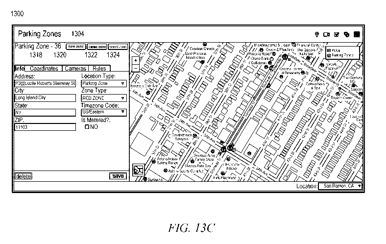
[0018] FIGs. 13A-13F are interface diagrams illustrating portions of an
example UI for creating or modifying a parking zone, according to some
embodiments.
[0019] FIGs. 14A-14D are interface diagrams illustrating portions of an
example UI for monitoring parking rule violations in a parking zone, according
to some embodiments.
[0020] FIGs. 15A-15B are interface diagrams illustrating portions of an
example UI for monitoring parking rule violations in a parking zone, according
to some embodiments.
3
CA 02984148 2017-10-26
WO 2016/168791 PCT/US2016/028022
[0021] FIG. 16 is an interface diagram illustrating an example UI for
monitoring parking space occupancy in a parking zone, according to some
embodiments.
[0022] FIG. 17 is an interface diagram illustrating an example UI for
presenting an overview of parking information of a municipality, according to
some embodiments.
[0023] FIG. 18 is a diagrammatic representation of a machine in the
example form of a computer system within which a set of instructions for
causing the machine to perform any one or more of the methodologies discussed
herein may be executed.
DETAILED DESCRIPTION
[0024] Reference will now be made in detail to specific example
embodiments for carrying out the inventive subject matter. Examples of these
specific embodiments are illustrated in the accompanying drawings, and
specific
details are set forth in the following description in order to provide a
thorough
understanding of the subject matter. It will be understood that these examples
are not intended to limit the scope of the claims to the illustrated
embodiments.
On the contrary, they are intended to cover such alternatives, modifications,
and
equivalents as may be included within the scope of the disclosure.
[0025] Aspects of the present disclosure involve systems and methods
for monitoring parking policy violations. In example embodiments, data is
streamed from multiple camera nodes to a parking policy management system
where the data is processed to determine if parking spaces are occupied and if
vehicles occupying the parking spaces are in violation of parking policies.
The
data streamed by the camera nodes includes metadata that includes information
describing images (also referred to herein as "parking metadata") captured by
the camera nodes along with other information related to parking space
occupancy. Each camera node may be configured such that the images captured
by the node show at least one parking space, and in some instances, vehicles
parked in the parking spaces, or in motion near the parking spaces. Each
camera
node is specially configured (e.g., with application logic) to analyze the
captured
images to provide pixel coordinates of vehicles in the image as part of the
4
CA 02984148 2017-10-26
WO 2016/168791 PCT/US2016/028022
metadata along with a timestamp, a camera identifier, a location identifier,
and a
vehicle identifier.
[0026] The metadata provided by the camera nodes may be sent via a
messaging protocol to a messaging queue of the parking policy management
system where back-end analytics store the pixel coordinate data in a
persistent
format to a back-end database. Sending the metadata rather than the images
themselves provides the ability to send locations of parked or moving vehicles
in
great numbers for processing and removes dependency on camera modes to send
images in bulk for processing. Further, by sending the metadata rather than
the
images, the system reduces the amount of storage needed to process parking
rule
validations.
[0027] Parking policies discussed herein may include a set of parking
rules that regulate the parking of vehicles in the parking spaces. The parking
rules may, for example, impose time constraints (e.g., time limits) on
vehicles
parked in parking spaces. The processing performed by the parking policy
management system includes performing a number of validations to determine
whether the parking space is occupied and whether the vehicle occupying the
space is in violation of one or more parking rules included in the parking
policy.
In performing these validations, the parking policy management system
translates the pixel coordinates of vehicles received from the camera nodes
into
global coordinates (e.g., real-world coordinates) and compares the global
coordinates of the vehicles to known coordinates of parking spaces. The
parking
policy management system may process the data in real-time or in mini batches
of data at a configurable frequency.
[0028] The parking policy management system includes a parking rules
engine to process data streamed from multiple camera nodes to determine, in
real-time, if a parked vehicle is in violation of a parking rule. The parking
rules
engine provides the ability to run complex parking rules on real-time
streaming
data, and flag data if a violation is found in real-time. The parking rules
engine
may further remove dependency on camera nodes to determine if a vehicle is in
violation. Multiple rules may apply for a parking space or zone and the
parking
rules engine may determine which rules apply based on the timestamp and other
factors. The parking rules engine enables complex rule processing to occur
CA 02984148 2017-10-26
WO 2016/168791 PCT/US2016/028022
using the data streamed from the camera nodes and the parking spaces or zones
stored rules data.
[0029] By processing the data in the manner described above, the
parking policy management system provides highly efficient real-time
processing of data (e.g., metadata describing image data) from multiple camera
nodes. Further, the parking policy management system may increase the speed
with which parking violations are identified, and thereby reduce costs in
making
such determinations.
[0030] Additional aspects of the present disclosure involve tracking
moving vehicles appearing in multiple images received from different cameras.
As an example, cameras may be mounted on street light poles to have a view of
the street, which allows the cameras to record images of traffic (e.g., moving
vehicles) on the street. The same moving vehicle may appear in multiple images
captured by the cameras, and the cameras have overlapping views. Each of the
cameras transmits parking metadata to the parking policy management system
where the parking metadata is processed to identify the same moving vehicle
appearing in the multiple images. Upon determining that the vehicle is moving
and that the same vehicle is shown in the multiple images, the parking policy
management system converts pixel coordinates (e.g., included in the parking
metadata) of the vehicle to global coordinates (e.g., geospatial coordinates),
and
stores a record of the locations defined by the global coordinates so as to
track
each location passed or visited by the vehicle. For example, the parking
policy
management system may plot the location of vehicles on a geospatial map to
track movement of traffic. The traffic movement may be displayed on a user
interface, and various analytics may be performed to provide alerts and data
points to assist municipalities to resolve traffic issues or assist with city
planning. In this way, municipalities that face challenging traffic
congestions,
which results in loss of income, safety hazards, and a decreasing in life
quality of
its citizens, may be provided with the ability to track traffic so that the
municipalities may make better decisions and provide alerts to officials and
citizens.
[0031] Additional aspects of the present disclosure involve UIs provided
by the parking policy management system to show real-time parking space
occupancy and parking policy violations on a geospatial map. Users such as
6
CA 02984148 2017-10-26
WO 2016/168791 PCT/US2016/028022
parking attendants can use the UIs of the parking policy management system to
identify locations of parking violations and review further information for
each
violation such as an addresses of the violation, parking rules being violated,
a
timing of the violation, images of the vehicle in violation of the parking,
and
information about the vehicles (e.g., make, model, color, and license plate
number).
[0032] Additional aspects of the present disclosure involve UIs to create
and edit parking zones with associated parking policies. Each parking zone
includes at least one parking space. The UIs may provide users with the
ability
to specify parking zone locations. For example, users may manually enter
coordinates of parking space or users may trace the outline of a parking zone
location on a geospatial map presented as part of the UI. The UI may further
allow users to define a parking policy associated with the parking zone that
includes one or more parking rules. Users may also use such UIs to associate
cameras with the parking zone so as to facilitate a linking between parking
zones
and the cameras that record images of portions of the parking zone.
[0033] FIG. 1 is an architecture diagram showing a network system 100
having a client-server architecture configured for monitoring parking policy
violations, according to an example embodiment. While the network system 100
shown in FIG. 1 may employ a client-server architecture, the present inventive
subject matter is, of course, not limited to such an architecture, and could
equally
well find application in an event-driven, distributed, or peer-to-peer
architecture
system, for example. Moreover, it shall be appreciated that although the
various
functional components of the network system 100 are discussed in the singular
sense, multiple instances of one or more of the various functional components
may be employed.
[0034] As shown, the network system 100 includes a parking policy
management system 102, a client device 104, and a camera node 106, all
communicatively coupled to each other via a network 108. The parking policy
management system 102 may be implemented in a special-purpose (e.g.,
specialized) computer system, in whole or in part, as described below.
[0035] Also shown in FIG. 1 is a user 110, who may be a human user
(e.g., a parking attendant, parking policy administrator, or other such
parking
enforcement personnel), a machine user (e.g., a computer configured by a
7
CA 02984148 2017-10-26
WO 2016/168791 PCT/US2016/028022
software program to interact with the client device 104), or any suitable
combination thereof (e.g., a human assisted by a machine or a machine
supervised by a human). The user 110 is associated with the client device 104
and may be a user of the client device 104. For example, the client device 104
may be a desktop computer, a vehicle computer, a tablet computer, a
navigational device, a portable media device, a smart phone, or a wearable
device (e.g., a smart watch, smart glasses, smart clothing, or smart jewelry)
belonging to the user 110.
[0036] The client device 104 may also include any one of a web client
112 or application 114 to facilitate communication and interaction between the
user 110 and the parking policy management system 102. In various
embodiments, information communicated between the parking policy
management system 102 and the client device 104 may involve user-selected
functions available through one or more user interfaces (UIs). The UIs may be
specifically associated with the web client 112 (e.g., a browser) or the
application 114. Accordingly, during a communication session with the client
device 104, the parking policy management system 102 may provide the client
device 104 with a set of machine-readable instructions that, when interpreted
by
the client device 104 using the web client 112 or the application 114, cause
the
client device 104 to present the UI, and transmit user input received through
such UIs back to the parking policy management system 102. As an example,
the UIs provided to the client device 104 by the parking policy management
system 102 allow users to view information regarding parking space occupancy
and parking policy violations overlaid on a geospatial map.
[0037] The network 108 may be any network that enables
communication between or among systems, machines, databases, and devices
(e.g., between parking policy management system 102 and the client device
104). Accordingly, the network 108 may be a wired network, a wireless network
(e.g., a mobile or cellular network), or any suitable combination thereof The
network 108 may include one or more portions that constitute a private
network,
a public network (e.g., the Internet), or any suitable combination thereof
Accordingly, the network 108 may include one or more portions that incorporate
a local area network (LAN), a wide area network (WAN), the Internet, a mobile
telephone network (e.g., a cellular network), a wired telephone network (e.g.,
a
8
CA 02984148 2017-10-26
WO 2016/168791 PCT/US2016/028022
plain old telephone system (POTS) network), a wireless data network (e.g., a
WiFi network or WiMax network), or any suitable combination thereof Any
one or more portions of the network 108 may communicate information via a
transmission medium. As used herein, "transmission medium" refers to any
intangible (e.g., transitory) medium that is capable of communicating (e.g.,
transmitting) instructions for execution by a machine (e.g., by one or more
processors of such a machine), and includes digital or analog communication
signals or other intangible media to facilitate communication of such
software.
[0038] The camera node 106 includes a camera 116 and node logic 118.
The camera 116 may be any of a variety of image capturing devices configured
for recording images (e.g., single images or video). The camera node 106 may
be or include a street light pole, and may be positioned such that the camera
116
captures images of a parking space 120. The node logic 118 may configure the
camera node 106 to analyze the images 120 recorded by the camera 116 to
provide pixel coordinates of a vehicle 122 that may be shown in an image 124
along with the parking space 120. The camera node 106 transmits data packets
that include parking metadata 126 that includes the pixel coordinates of the
vehicle 122 to the parking policy management system 102 (e.g., via a messaging
protocol) over the network 108. The parking policy management system 102
uses the pixel coordinates included in the parking metadata 122 received from
the camera node 106 to determine whether the vehicle 122 is occupying (e.g.,
parked in) the parking space 120. For as long as the vehicle 122 is included
in
images recorded by the camera 116, the camera node 106 continues to transmit
the pixel coordinates of the vehicle 122 to the parking policy management
system 102, and the parking policy management system 102 uses the pixel
coordinates to monitor the vehicle 122 to determine if the vehicle 122 is in
violation of one or more parking rules included in a parking policy that is
applicable to the parking space 120.
[0039] FIG. 2 is an interaction diagram illustrating example interactions
between components of the network system 100, according to some
embodiments. In particular, FIG. 2 illustrates example interactions that occur
between the parking policy management system 102, client device 104, and the
camera node 106 as part of monitoring parking policy violations occurring with
respect to the parking space 122.
9
CA 02984148 2017-10-26
WO 2016/168791 PCT/US2016/028022
[0040] As shown, at operation 202 the camera 116 of the camera node
106 records an image 124. As noted above, the camera 116 is positioned such
that the camera 116 records images that show the parking space 120. The image
124 recorded by the camera 116 may further show the vehicle 122 that, upon
initial processing, appears to the camera node 106 as a "blob" in the image
124.
[0041] At operation 204, the node logic 118 configures the camera node
106 to perform image analysis on the image 124 to determine the pixel
coordinates of the blob. The pixel coordinates are a set of spatial
coordinates
that identify the location of the blob within the image itself
[0042] At operation 206, the camera node 106 transmits the parking
metadata 126 (e.g., including information describing the recorded image 124)
over the network 108 to the parking policy management system 102. The
camera node 106 may transmit the metadata 126 as a data packet using a
standard messaging protocol. The parking metadata 126 includes the pixel
coordinates of the blob (e.g., the vehicle 122) along with a timestamp (e.g.,
a
date and time the image was recorded), a camera identifier (e.g., identifying
the
camera 116), a location identifier (e.g., identifying the camera node 106 or a
location of the camera node 106), and a blob identifier (e.g., a unique
identifier
assigned to the vehicle 122). The camera node 106 may continuously transmit
(e.g., at predetermined intervals) the parking metadata while the vehicle 122
continues to be shown in image recorded by the camera 116.
[0043] At operation 208, the parking policy management system 102
receives the data packet and persists (e.g. saves) the parking metadata 126 to
a
data store (e.g., a database). In persisting the parking metadata 126 to the
data
store, the parking policy management system 102 may create or modify a data
object associated with the camera node 106 or the parking space 120. The
created or modified data object includes the received parking metadata 126. As
the camera node 106 continues to transmit subsequent parking metadata, the
parking policy management system 102 may store the subsequent parking
metadata received from the camera node 106 in the same data object or in
another data object that is linked to the same data object. In this way, the
parking policy management system 102 maintains a log of parking activity with
respect to the parking space 120. It shall be appreciated that the parking
policy
management system 102 may be communicatively coupled to multiple instances
CA 02984148 2017-10-26
WO 2016/168791 PCT/US2016/028022
of the camera node 106 that record images showing other parking spaces, and
the parking policy management system 102 may accordingly maintain separate
records for each camera node 106 and/or parking spaces so as to maintain a log
of parking activity with respect to a group of parking spaces.
[0044] At operation 210, the parking policy management system 102
processes the parking metadata 126 received from the camera node 106. The
processing of the parking metadata 126 may, for example, include determining
an occupancy status of the parking space 120. The occupancy status of the
parking space 120 may be either occupied (e.g., a vehicle is parked in the
parking space) or unoccupied (e.g., no vehicle is parked in the parking
space).
Accordingly, the determining of the occupancy status of the parking space 120
includes determining whether the vehicle 122 is parked in the parking space
120.
In determining that the vehicle 122 is parked in the parking space 120, the
parking policy management system 102 verifies that the location of the vehicle
122 overlaps the location of the parking space 120, and the parking policy
management system 102 further verifies that the vehicle is still (e.g., not in
motion). If the parking policy management system 102 determines the vehicle
122 is in motion, the parking policy management system 102 flags the vehicle
122 for further monitoring.
[0045] Upon determining that the parking space 120 is occupied by the
vehicle 122 (e.g., the vehicle 122 is parked in the parking space 120), the
parking policy management system 102 determines whether the vehicle 122 is in
violation of a parking rule that is applicable to the parking space 120. In
determining whether the vehicle is in violation of a parking rule, the parking
policy management system 102 monitors further metadata transmitted by the
camera node 106 (e.g., metadata describing subsequent images captured by the
camera 116). The parking policy management system 102 further accesses a
parking policy specifically associated with the parking space 120. The parking
policy includes one or more parking rules. The parking policy may include
parking rules that have applicability only to certain times of day, or days of
the
week, for example. Accordingly, the determining of whether the vehicle is in
violation of a parking rule includes determining which, if any, parking rules
apply, and the applicability of parking rules may be based on the current time
of
day or current day of the week.
11
CA 02984148 2017-10-26
WO 2016/168791 PCT/US2016/028022
[0046] Parking rules may, for example, impose a time limit on parking in
the parking space 120. Accordingly, the determining of whether the vehicle 122
is in violation of a parking rule may include determining an elapsed time
since
the vehicle first parked in the parking space 120, and comparing the elapsed
time
to the time limit imposed by the parking rule.
[0047] At operation 212, the parking policy management system 102
generates presentation data corresponding to a user interface. The
presentation
data may include a geospatial map of the area surrounding the parking space
120, visual indicators of parking space occupancy, visual indicators of
parking
rule violations, visual indicators of locations visited by the vehicle 122
(e.g., if
vehicle 122 is determined to be in motion), identifiers of specific parking
rules
being violated, images of the vehicle 122, and textual information describing
the
vehicle (e.g., make, model, color, and license plate number). Accordingly, in
generating the presentation data, the parking policy management system 102
may retrieve, from the camera node 106, the first image showing the vehicle
122
parked in the parking space 120 (e.g., the first image from which the parking
policy management system 102 can determine the vehicle 122 is parked in the
parking space 120), and a subsequent image from which the parking monitoring
102 determined that the vehicle 122 is in violation of the parking rule (e.g.,
the
image used to determine the vehicle 122 is in violation of the parking rule).
The
UI may include the geospatial map overlaid with visual indicators of parking
space occupancy and parking rule violations that may be selectable (e.g.,
through
appropriate user input device interaction with the UI) to presented additional
UI
elements that include the images of the vehicle 122, and textual information
describing the vehicle.
[0048] At operation 214, the parking policy management system 102
transmits the presentation data to the client device 104 to enable the client
device
104 to present the UI on a display of the client device 104. Upon receiving
the
presentation data, the client device 104 may temporarily store the
presentation
data to enable the client device to display the UI, at operation 216.
[0049] FIG. 3 is a block diagram illustrating various modules comprising
a parking policy management system 100, which is provided as part of the
network system, according to some embodiments. To avoid obscuring the
inventive subject matter with unnecessary detail, various functional
components
12
CA 02984148 2017-10-26
WO 2016/168791 PCT/US2016/028022
(e.g., modules, engines, and databases) that are not germane to conveying an
understanding of the inventive subject matter have been omitted from FIG. 2.
However, a skilled artisan will readily recognize that various additional
functional components may be supported by the parking policy management
system 102 to facilitate additional functionality that is not specifically
described
herein.
[0050] As shown, the parking policy management system 102 includes:
an interface module 300; a data intake module 302; a policy creation module
304; a unique vehicle identification module 306; a coordinate translation
module
308; an occupancy engine 310 comprising an overlap module 312 and a motion
module 314; a parking rules engine 316; and a data store 318. Each of the
above
referenced functional components of the parking policy management system 102
are configured to communicate with each other (e.g., via a bus, shared memory,
a switch, or application programming interfaces (APIs)). Any one or more of
functional components illustrated in FIG. 3 and described herein may be
implemented using hardware (e.g., a processor of a machine) or a combination
of hardware and software. For example, any module described herein may
configure a processor to perform the operations described herein for that
module.
Moreover, any two or more of these modules may be combined into a single
module, and the functions described herein for a single module may be
subdivided among multiple modules. Furthermore, according to various
example embodiments, any of the functional components illustrated in FIG. 3
may be implemented together or separately within a single machine, database,
or
device may be distributed across multiple machines, databases, or devices.
[0051] The interface module 300 receives requests from the client device
104, and communicates appropriate responses to the client device 104. The
interface module 300 may receive requests from devices in the form of
Hypertext Transfer Protocol (HTTP) requests or other web-based, API requests.
For example, the interface module 300 provides a number of interfaces (e.g.,
APIs or UIs that are presented by the device 104) that allow data to be
received
by the parking policy management system 102.
[0052] For example, the interface module 300 may provide a policy
creation UI that allows the user 110 of the client device 104 to create
parking
policies (e.g., a set of parking rules) associated with a particular parking
zone
13
CA 02984148 2017-10-26
WO 2016/168791 PCT/US2016/028022
(e.g., a set of parking spaces). The interface module 300 also provides
parking
attendant UIs to the client device 104 to assist the user 110 (e.g., parking
attendants or other such parking enforcement personnel) in monitoring parking
policy violations in their assigned parking zone. To provide a UI to the
client
device 104, the interface module 300 transmits presentation data to the client
device 104 that enables the client device 104 to present the UI on a display
of the
client device 104. In some embodiments, the interface module 300 may transmit
the presentation data to the client device 104 along with a set of
instructions to
display the presentation data. The client device 104 may temporarily store the
presentation data to enable display of the UI.
100531 The UIs provided by the interface module 300 may include
various maps, graphs, tables, charts, and other graphics used, for example, to
provide information related to parking space occupancy and parking policy
violations. The interfaces may also include various input control elements
(e.g.,
sliders, buttons, drop-down menus, check-boxes, and data entry fields) that
allow
users to specify various inputs, and the interface module 300 receives and
processes user input received through such input control elements.
[0054] The data intake module 302 is responsible for obtaining data
transmitted from the camera node 106 to the parking policy management system
102. For example, the data intake module 302 may receive data packets that
include parking metadata (e.g., parking metadata 126) from the camera node
106. The data packets may, for example, be transmitted by the camera node 106
using a messaging protocol and upon receipt, the data intake module 302 may
add the parking metadata from the data packet to a messaging queue (e.g.,
maintained in the data store 318) for subsequent processing. The data intake
module 302 may persist the parking metadata to one or more data objects stored
in the data store 318. For example, the data intake module 302 may modify a
data object associated with the camera 106, the parking space 120, or the
vehicle
122 to include the received parking metadata 126.
[0055] In some instances, multiple cameras (e.g., multiple instances of
camera 116) may record an image (e.g., image 124) of the parking space 120 and
the vehicle 122. In these instances, the data intake module 302 may analyze
the
metadata associated with each of the images to determine which image to use
for
processing. More specifically, the data intake module 302 analyzes parking
14
CA 02984148 2017-10-26
WO 2016/168791 PCT/US2016/028022
metadata for multiple images, and based on a result of the analysis, the data
intake module 302 selects a single instance of parking metadata (e.g., a
single set
of pixel coordinates) to persist in the data store 318 for association with
the
parking space 120 or the vehicle 122.
[0056] The data intake module 302 may be further configured to retrieve
actual images recorded by the camera 116 of the camera node 106 (or other
instances of these components) for us by the interface module 300 in
generating
presentation data that represents a UI. For example, upon determining that the
vehicle 122 is in violation of a parking rule applicable to the parking space
120,
the data intake module 302 may retrieve two images from the camera node 106 ¨
a first image corresponding to first parking metadata used to determine the
vehicle 122 is parked in the parking space 120 and a second image
corresponding to second parking metadata used to determine the vehicle 122 is
in violation of the parking rule applicable to the parking space 120.
[0057] The policy creation module 304 is responsible for creating and
modifying parking policies associated with parking zones. More specifically,
the parking creation module 304 may be utilized to create or modify parking
zone data objects (e.g., parking zone data object 400) that include
information
describing parking policies associated with a parking zone. In creating and
modifying parking zone data objects, the policy creation module 304 works in
conjunction with the interface module 300 to receive user specified
information
entered into various portions of the policy creation UI. For example, a user
may
specify a location of a parking zone (or a parking space within the parking
zone)
by tracing an outline of the location on a geospatial map included in a
parking
zone creating interface provided by the interface module 300. The policy
creation module 304 may convert the user input (e.g., the traced outline) to a
set
of global coordinates (e.g., geospatial coordinates) based on the position of
the
outline on the geospatial map. The policy creation module 304 incorporates the
user-entered information into a parking zone data object associated with a
particular parking zone and persists (e.g., stores) the parking zone data
object in
the data store 318.
[0058] The unique vehicle identification module 306 is responsible for
identifying unique vehicles shown in multiple images recorded by multiple
cameras. In other words, the unique vehicle identification module 306 may
CA 02984148 2017-10-26
WO 2016/168791 PCT/US2016/028022
determine that a first blob shown in a first image is the same as a second
blob
shown in the second image, and that both of which correspond to the same
vehicle (e.g., vehicle 122). In determining the vehicle 122 is shown in both
images, the unique vehicle identification module 306 access known information
(e.g., from the data store 318) about the angle, height, and position of the
first
and second camera using unique camera identifiers included in metadata of the
images. Using the known information about the physical orientation of the
first
and second camera such as angle, height, and position of the first and second
camera, the unique vehicle identification module 306 compares the locations of
the blobs (e.g., geo-graphic locations represented by a set of global
coordinates)
to determine if the difference in location of the blobs is below an allowable
threshold. The allowable threshold may, for example, be based on an expected
trajectory of a vehicle in the area of the first and second camera based on
speed
limits, traffic conditions, and other such factors. Based on the determined
location difference being below the allowable threshold, the unique vehicle
identification module 306 determines the blob (e.g., vehicle) shown in the
first
image is also the blob (e.gõ vehicle) shown in the second image.
[0059] The coordinate translation module 308 is responsible for
translating pixel coordinates (e.g., defining a location in the image space)
to
global coordinates (e.g., defining a geo-graphic location in the real-world).
As
noted above, the camera node 106 transmits parking metadata 126 to the parking
policy management system 102 that includes a set of pixel coordinates that
define a location of a blob (e.g., vehicle 122) within the image space. The
coordinate translation module 308 is thus responsible for mapping the location
of the blob (e.g., vehicle 122) within the image space to a geo-graphic
location
in the real-world by converting the set of pixel coordinates to a set of
global
(e.g., geo-graphic) coordinates. In converting pixel coordinates to global
coordinates, the coordinate translation module 308 may use the known angle,
height, and position of the camera that recorded the image (e.g., included in
a
data object associated with the camera and maintained in the data store 318)
in
conjunction with a homography matrix to determine the corresponding global
coordinates. The coordinate translation module 308 may further persist each
set
of global coordinates to a data object associated with either the parking
space
120 or vehicle 122, or both.
16
CA 02984148 2017-10-26
WO 2016/168791 PCT/US2016/028022
[0060] The occupancy engine 310 is responsible for determining
occupancy status of parking spaces. The occupancy engine 310 may determine
the occupancy status of parking spaces based on an analysis of parking
metadata
associated with the parking space. The occupancy status refers to whether a
parking space is occupied (e.g., a vehicle is parked in the parking space) or
unoccupied (e.g., no vehicle is parked in the parking space). As an example,
the
occupancy engine 310 may analyze the parking metadata 126 to determine
whether the parking space 120 is occupied by the vehicle 122.
[0061] In determining the occupancy status of the parking space 120, the
occupancy engine 310 may invoke the functionality of the overlap module 312
the motion module 314. The overlap module 312 is responsible for determining
whether the location of a blob shown in an image overlaps (e.g., covers) a
parking space based on image data describing the image. For example, the
overlap module 312 determines whether the location of the vehicle 122 overlaps
the location of the parking space 120 based on the parking metadata 126. The
overlap module 312 determines whether the blob overlaps the parking space
based on a comparison of a location of the blob (e.g., as represented by or
derived from the set of pixel coordinates of the blob included in the parking
metadata) and known location of the parking space (e.g., included in a data
object associated with the parking space). In comparing the two locations, the
overlap module 312 may utilize centroid logic 320 to compute an arithmetic
mean of the locations of the blob and the parking space represented by sets of
coordinates (e.g., either global or pixel) defining the location of each.
[0062] The motion module 314 is responsible for determining whether
blob (e.g., a vehicle) shown in images are in motion. The motion module 314
determines whether a blob shown in an image is in motion by comparing
locations of the blob from parking metadata of multiple images. For example,
the motion module 314 may compare a first set of pixel coordinates received
from the camera node 106 corresponding to the location of the vehicle 122 in a
first image with a second set of pixel coordinates received from the camera
node
106 corresponding to the location of the blob in a second image, and based on
the resulting difference in location transgressing a configurable threshold,
the
motion module 314 determines that the vehicle 122 is in motion. The motion
module 314 may also utilize the centroid logic 320 in comparing the sets of
pixel
17
CA 02984148 2017-10-26
WO 2016/168791 PCT/US2016/028022
locations to determine the difference in location of the vehicle 122 in the
two
images.
[0063] If the motion module 314 determines that the vehicle 122 is in
motion, the motion module 314 adds the locations of the vehicle 122 (e.g.,
derived from the sets of pixel coordinates) to a data object associated with
the
vehicle 122 and flags the vehicle 122 for further monitoring. Furthermore, if
the
motion module 314 determines that the vehicle 122 is in motion, or if the
overlap module 312 determines that the location of the vehicle 122 does not
overlap the location o fhte parking space 120, the occupancy engine 310
determines that the occupancy status of the parking space 120 is "unoccupied."
If the motion module 314 determines that the vehicle 122 is stationary (e.g.,
not
in motion) and the overlap module 312 determines the location of the vehicle
122 overlaps the location of the parking space 120, the occupancy engine 310
determines that the occupancy status of the parking space 120 is "occupied."
[0064] The parking rules engine 316 is responsible for determining
parking rule violations based on parking metadata. As an example, in response
to the occupancy engine 310 determining that the parking space 120 is occupied
by the vehicle 122, the parking rules engine 316 checks whether the vehicle
122
is in violation of a parking rule included in a parking policy associated with
the
parking space. In determining whether the vehicle 122 is in violation of a
parking rule, the parking rules engine 316 accesses a parking zone data object
associated with the parking zone in which the parking space is located. The
parking zone data object includes the parking policy associated with the
parking
zone. The parking policy may include a set of parking rules that limit parking
in
the parking zone. Parking rules may be specifically associated with particular
parking spaces, and may have limited applicability to certain hours of the
day,
days of the week, or days of the year. Accordingly, in determining whether the
vehicle 122 is in violation of a parking rule, the parking rules engine 316
determines which parking rules from the parking policy are applicable based on
comparing a current time with timing attributes associated with each parking
rule. Some parking rules may place a time limit on parking in the parking
space
120, and thus, the parking rules engine 316 may determine whether the vehicle
122 is in violation of a parking rule based on an elapsed time of the vehicle
122
18
CA 02984148 2017-10-26
WO 2016/168791 PCT/US2016/028022
being parked in the parking space 120 exceeding the time limit imposed by one
or more parking rules.
[0065] The data store 318 stores data objects pertaining to various
aspects and functions of the parking policy management system 102. For
example, the data store 318 may store: camera data objects including
information about cameras such as an camera identifier, and orientation
information such as angles, height, and position of the camera; parking zone
data
objects including information about known geospatial locations (e.g.,
represented by global coordinates) of parking spaces in the parking zone,
known
locations of parking spaces within images recorded by cameras in the parking
zone (e.g., represented by pixel coordinates), and parking policies applicable
to
the parking zone; and vehicle data objects including an identifier of the
vehicle,
locations of the vehicle, images of the vehicle, and records of parking policy
violations of the vehicle. Within the data store 318, camera data objects may
be
associated with parking zone data objects so as to maintain a linkage between
parking zones and the cameras that record images of parking spaces and
vehicles
in the parking zone. Further, vehicle data objects may be associated with
parking zone data objects so as to maintain a linkage between parking zones
and
the vehicles parked in a parking space in the parking zone. Similarly, camera
data objects may be associated with vehicle data objects so as to maintain a
linkage between cameras and the vehicles shown in images recorded by the
cameras.
[0066] As more detailed example of the data objects that may be stored
in the data store 318, FIG. 4 is a data structure diagram illustrating
elements of a
parking zone data object 400, according to some embodiments. The parking
zone data object 400 is a data structure stored in the data store 318 of the
parking
policy management system 102. The parking zone data object 400 includes
multiple fields for maintaining pertinent information describing a parking
policy
associated with a parking zone. For example, the parking zone data object 400
includes an identifier 402 that uniquely identifies the parking zone. The
identifier 402 may be assigned to the parking zone by the parking policy
management system 102 upon creation of the parking zone data object 400.
19
CA 02984148 2017-10-26
WO 2016/168791 PCT/US2016/028022
[0067] The parking zone data object 400 also includes a description 404
of the parking zone. The description 404 may, for example, include a human-
generated (e.g., user 110) textual description of the parking zone.
[0068] The parking zone data object 400 also includes location data 406
describing a location of the parking zone. The location data 406 may include a
set of geospatial coordinates that define the perimeter of the parking zone
(e.g.,
by providing a coordinate pair for each corner of the parking zone). Each
parking zone may include one or more parking spaces, and as such, the location
data 406 may include information describing the location of each parking space
in the parking zone. In particular, the location data 406 includes a set of
geospatial coordinates (e.g., global coordinates) for each parking space in
the
parking zone. The location data 406 may, in some embodiments, include a set of
pixel coordinates for each parking space that define a location of each
parking
space in images recorded by nearby cameras.
[0069] The parking zone data object 400 further includes a parking
policy 408. The parking policy includes a set of parking rules that are
applicable
to the parking zone. The parking rules include limits on parking in the
parking
zone. For example, a parking rule may impose a time limit on parking in the
parking zone (e.g., two hour maximum). Individual parking rules may be
specifically associated with a particular parking space or set of parking
spaces in
the parking zone, or may be generally associated with the entire parking zone.
Each parking rule may have a one or more temporal attributes that temporally
limit the applicability of the rule. For example, a particular parking rule
may be
applicable during certain hours of the day (e.g., from 6:00 AM to 6:00 PM),
certain days of the week (e.g., Wednesdays), or certain days of the year
(e.g.,
holidays).
[0070] The parking zone data object 400 may further include a field for
camera identifiers 410. The camera identifiers 410 field includes identifiers
of
cameras (e.g., instances of camera 116) that record images of parking spaces
in
the parking zone. In some instances, a parking zone may have only a single
camera that records images of the parking zone, and the camera identifiers 410
field includes only a single identifier. In other instances, a parking zone
may
have multiple cameras that record images of the parking zone, and the camera
identifiers 410 field includes multiple identifiers.
CA 02984148 2017-10-26
WO 2016/168791 PCT/US2016/028022
[0071] FIG. 5 is a flowchart illustrating a method 500 for creating a new
parking zone with an associated parking policy, according to some
embodiments. The method 500 may be embodied in computer-readable
instructions for execution by one or more processors such that the operations
of
the method 500 may be performed in part or in whole by the parking policy
management system 102; accordingly, the method 500 is described below by
way of example with reference thereto. However, it shall be appreciated that
at
least some of the operations of the method 500 may be deployed on various
other hardware configurations and the method 500 is not intended to be limited
to the parking management system 102.
[0072] At operation 505, the interface module 300 causes display of a
parking zone creation UI on the client device 104. The parking zone creation
UI
includes a number of data input elements (e.g., text fields, drop-down menus,
and buttons) for receiving information describing a parking policy associated
with a particular parking zone. The parking zone creation UI may further
include a geospatial map configured to receive user input (e.g., through
appropriate interaction with an input device) specifying a location of a
parking
zone.
[0073] In causing presentation of the UI, the interface module 300 may
transmit presentation data to the client device 104 to cause the client device
104
to present the UI on a display of the client device 104. Upon receiving the
presentation data, the client device 104 may temporarily store the
presentation
data to enable the client device to display the UI.
[0074] At operation 510, the policy creation module 304 receives, from
the client device 104, a human-generated parking zone description entered via
the parking zone creation UI. The parking zone description includes a textual
description of the parking zone.
[0075] At operation 515, the policy creation module 304 receives, from
the client device 104, parking zone location data entered via the parking zone
creation UI. The parking zone location data includes information describing a
location of the parking zone and locations of each parking space within the
parking zone. In some embodiments, the user 110 may enter the location data
using input elements in the UI such as drop-down menus or text input boxes.
For example, the user 110 may use text input boxes to specify a set of global
21
CA 02984148 2017-10-26
WO 2016/168791 PCT/US2016/028022
coordinates (e.g., geospatial coordinates) for each parking space in the
parking
zone (e.g., a coordinate pair for each corner of the parking space).
[0076] In other embodiments, the user 110 may specify the location of
the parking zone and parking space included therein by providing input
directly
to the geospatial map displayed within the policy creation UI that specifies a
location of the parking zone or a particular parking space. For example, the
user
110 may manipulate a mouse cursor (e.g., through physical interaction with a
mouse) or use a touch-based gesture (e.g., for devices with touch-based
displays)
to trace an outline of the location of the parking space on the geospatial
map.
Upon receiving the user 110's input on the geospatial map (e.g., the traced
outline of the parking zone), the policy creation module 304 converts the
input to
one or more sets of global coordinates (e.g., geo-graphic coordinates) based
on
the position of the outline of the parking zone on the geospatial map.
[0077] At operation 520, the policy creation module 304 generates a
parking zone data object (e.g., the parking zone data object 400) for the
parking
zone defined by the received location data. As noted above, the parking zone
data object is a data structure that includes information describing the
parking
policy for the parking zone. In generating the parking zone data object, the
policy creation module 304 may automatically assign (e.g., without further
user
intervention) an identifier to the parking zone that uniquely identifies the
parking
zone.
[0078] At operation 525, the policy creation module 304 receives, from
the client device 104, a parking policy definition entered using the parking
zone
creation UI. The parking definition defines the parking policy associated with
the parking zone defined by the received location data. The parking policy
definition may be entered using a variety of graphical elements such as drop-
down menus or text entry fields.
[0079] Each parking policy includes a set of parking rules, and each rule
may include a temporal attribute that temporally limits the applicability of
the
rule. The user 110 may, for example, select individual parking rules from a
drop-down menu that includes a list of predefined parking rules. Parking rules
may, for example, correspond to parking regulation codified in a municipal or
cited code. The user 110 may, for example, specify temporal attributes for
each
selected parking rule using an additional UI element (e.g., drop-down menu or
22
CA 02984148 2017-10-26
WO 2016/168791 PCT/US2016/028022
date picker) displayed in the parking creation interface in conjunction with
the
drop-down menu of predefined parking rules, and the user interface module 300
may receive the user-specified temporal attributes and provide them to the
policy
creation module 304 for association with the corresponding parking rule.
[0080] At operation 530, the policy creation module 304 modifies (e.g.,
augments) the parking zone data object to include the parking policy defined
by
the parking policy definition received from the user 110. For example, the
policy creation module 304 may store the set of rules composing the parking
policy in a parking policy field (e.g., parking policy 408) of the parking
zone
data object.
[0081] At operation 535, the policy creation module 304 receives, from
the client device 104, one or more camera identifiers entered via the policy
creation interface. Each camera identifier uniquely identifies a camera (e.g.,
camera 116) that records images showing at least a portion of the parking
zone.
[0082] At operation 540, the policy creation module 304 associates the
one or more camera identifiers with the parking zone data object. The
associating of a camera identifier with the parking zone data object includes
electronically linking the parking zone data object with a different data
object
associated with the camera identifier (e.g., a data object storing information
describing the identified camera). The electronic linking may include
modifying
(e.g., augmenting) the parking zone data object to include the camera
identifier
(e.g., storing the camera identifier in the camera identifiers 410 field of
the
parking zone data object 400).
[0083] At operation 545, the policy creation module 304 persists (e.g.,
stores) the parking zone data object in the data store 318 of the parking
policy
management system 102. In this way, the parking policy management system
102 may subsequently access parking zone data object to determine parking
space occupancy and parking rule violation in connection with the parking
spaces included in the parking zone.
[0084] FIG. 6 is a flowchart illustrating a method 600 for monitoring
parking policy violations, according to some embodiments. The method 600
may be embodied in computer-readable instructions for execution by one or
more processors such that the operations of the method 600 may be performed in
part or in whole by the parking policy management system 102; accordingly, the
23
CA 02984148 2017-10-26
WO 2016/168791 PCT/US2016/028022
method 600 is described below by way of example with reference thereto.
However, it shall be appreciated that at least some of the operations of the
method 600 may be deployed on various other hardware configurations and the
method 600 is not intended to be limited to the parking management system 102.
[0085] At operation 605, occupancy engine 310 accesses parking
metadata associated with an image recorded by the camera node 106. As noted
above, the camera node 106 is positioned such that the camera 116 records
images of the parking space 120. The parking metadata includes a set of pixel
coordinates corresponding to a blob (e.g., a polygon) shown in the image along
with the parking space 120. The set of coordinates include a coordinate pair
(e.g., an X-axis value and a Y-axis value) that define a location of each
corner of
the blob. The parking metadata may further include a timestamp (e.g., a date
and time the image was recorded), a camera identifier (e.g., identifying the
camera 116), a location identifier (e.g., identifying the camera node 106 or a
location of the camera node 106), and a blob identifier (e.g., a unique
identifier
assigned to the vehicle 122). As an example, the blob shown in the image may
correspond to the vehicle 122, though application of the methodologies
described herein is not necessarily limited to vehicles, and may find
application
in other contexts such with monitoring trash or other parking obstructions.
[0086] At operation 610, the occupancy engine 310 determines an
occupancy status of the parking space 120 shown in the image based on the
pixel
coordinates of the blob (e.g., vehicle 122) included in the metadata of the
image.
The occupancy status of a parking space indicates whether a vehicle is parked
in
the parking space 120. Accordingly, in determining the occupancy status of the
parking space 120, the occupancy engine 310 determines whether the vehicle
122 is parked in the parking space. The occupancy engine 310 may determine
the occupancy status of the parking space 120 based on a comparison of the
real-
world location of the blob (e.g., vehicle 122) to a known location (e.g., in
the
real-world) of the parking space 120 (e.g., accessed from a location look-up
table accessed from the data store 318). The location of the blob (e.g.,
vehicle
122) may be derived from the pixel coordinates and a known location of the
camera node 106. Further details of the process for determining occupancy of
parking spaces are discussed below in reference to FIGs. 8-11, according to
some embodiments.
24
CA 02984148 2017-10-26
WO 2016/168791 PCT/US2016/028022
[0087] At operation 615, the occupancy engine 310 updates one or more
data object (e.g., maintained in the data store 318) to reflect the occupancy
status
of the parking space 120. In some embodiments, the updating of the one or
more data objects includes updating a field in a data object corresponding to
the
parking space 120 to reflect that the parking space 120 is either occupied
(e.g., a
vehicle is parked in the parking space 120) or unoccupied (e.g., a vehicle is
not
parked in the parking space 120). In some embodiments, the updating of the one
or more data objects includes: updating a first field in a data object
corresponding to the vehicle 122 to include an indication of whether the
vehicle
122 is parked or in motion; and updating a second field in the data object
corresponding to the vehicle 122 to include the location of the vehicle 122 at
a
time corresponding to a timestamp of the image (e.g., included in the metadata
of the image).
[0088] In response to the occupancy engine 310 determining the vehicle
122 is parked in the parking space 120, the rules violation engine 308
determines
whether the vehicle 122 is in violation of a parking rule included in a
parking
policy associated with (e.g., applicable to) the parking space 120, at
decision
block 620. In determining whether the vehicle 122 is in violation of a parking
policy, the parking engine accesses a data object (e.g., a table) from the
data
store 318 that includes a parking policy applicable to the parking space 120.
The
parking policy may include one or more parking rules that impose a constraint
(e.g., a time limit) on parking in the parking space 120. Certain parking
rules
may be associated with certain times or dates. Accordingly, the determining of
whether the vehicle 122 is in violation of a parking rule includes determining
which parking rules of the parking policy are applicable to the vehicle 122,
which, may, in some instances, be based on the timestamp of the image (e.g.,
included in the parking metadata).
[0089] In instances in which an applicable parking rule includes a time
limit on parking in the parking space 120, the rules violation engine 308 may
monitor the parking metadata received from the camera 116 showing the parking
space 120 and the vehicle 120 to determine an elapsed time associated with the
occupancy of the parking space 120 by the vehicle 122. The rules violation
engine 308 may determine the elapsed time of the occupancy of the parking
space 120 based on a comparison of a first timestamp included in parking
CA 02984148 2017-10-26
WO 2016/168791 PCT/US2016/028022
metadata from which vehicle 122 was determined to be parked in the parking
space 120, and a second timestamp included in the metadata being analyzed.
Once the rules violation engine 308 determines the elapsed time associated
with
the occupancy of the parking space 120, the parking rules engine 308
determines
whether the elapsed time exceeds the time limit imposed by the parking rule.
[0090] If, at decision block 620, the parking rules engine 316 determines
the vehicle 122 is in violation of a parking rule included in the parking
policy
associated with the parking space 120, the method continues to operation 625
where the parking rules engine 316 updates a data object (e.g., stored and
maintained in the data store 318) associated with the vehicle 122 to reflect
the
parking rule violation. The updating of the data object may include augmenting
the data object to include an indication of the parking rule violation (e.g.,
setting
a flag corresponding to a parking rule violation). The updating of the data
object
may further include augmenting the data object to include an identifier of the
parking rule being violated.
[0091] At operation 630, the interface module 300 generates presentation
data representing a UI (e.g., a parking attendant interface) for monitoring
parking space occupancy and parking rules violations in a parking area that
includes the parking space 120. The presentation data may include images a
geospatial map of the area surrounding the parking space 120, visual
indicators
of parking space occupancy (e.g., based on information included in data
objects
associated with the parking spaces), visual indicators of parking rule
violations
(e.g., based on information included in data objects associated with the
parking
spaces), identifiers of specific parking rules being violated, images of the
vehicle
122, and textual information describing the vehicle (e.g., make, model, color,
and license plate number). Accordingly, in generating the presentation data,
the
parking policy management system 102 may retrieve, from the camera node 106,
a first image corresponding to a first timestamp included in parking metadata
from which vehicle 122 was determined to be parked in the parking space 120,
and a second image corresponding to the parking metadata from which the
parking monitoring 102 determined that the vehicle 122 is in violation of the
parking rule.
[0092] At operation 635, the interface module 300 causes presentation of
the UI on the client device 106. In causing presentation of the UI, the
interface
26
CA 02984148 2017-10-26
WO 2016/168791 PCT/US2016/028022
module 300 may transmit presentation data to the client device 104 to cause
the
client device 104 to present the UI on a display of the client device 104.
Upon
receiving the presentation data, the client device 104 may temporarily store
the
presentation data to enable the client device to display the UI.
100931 The UI may include the geospatial map overlaid with visual
indicators of parking space occupancy and parking rule violations that may be
selectable (e.g., through appropriate user input device interaction with the
UI) to
presented additional UI elements that include the images of the vehicle 122,
and
textual information describing the vehicle. Further details of example
interfaces
provided by the parking policy management system 102 are discussed below in
reference to FIGs. 13-17, according to some embodiments.
[0094] In some instances, multiple camera nodes may record an image
of the same view (e.g., images of the same vehicle and parking space) and send
the parking metadata for these images to the parking policy management system
102. In these instances, the parking policy management system 102 may
identify and select a single image for processing to reduce the number of
calculations performed in furtherance of processing parking space occupancy
and parking rule violations. Accordingly, as shown in FIG. 7, the method 600
may include the additional operations 705, 710, 715, 720, and 725, which
relate
to selecting a single image from multiple images showing the parking space
120.
In some example embodiments, operations 705, 710, 715, 720, and 725 included
in the method 600 may be performed prior to or as part (e.g., a precursor
task, a
subroutine, or a portion) of operation 605 of method 600, in which the
occupancy engine 310 accesses parking metadata data describing an image
showing the parking space 120 and the vehicle 122.
[0095] At operation 705, the data intake module 302 receives metadata
associated with multiple images. The metadata for each image includes a set of
pixel coordinates (e.g., a coordinate pair defining a location of each corner)
corresponding to a blob (e.g., a polygon) shown in the image, a timestamp
(e.g.,
a date and time the image was recorded), a camera identifier (e.g.,
identifying
the camera 116), a location identifier (e.g., identifying the camera node 106
or a
location of the camera node 106), and a blob identifier (e.g., a unique
identifier
assigned to the vehicle 122).
27
CA 02984148 2017-10-26
WO 2016/168791 PCT/US2016/028022
[0096] At operation 710, the data intake module 302 determines, based
on the metadata, that each of the multiple image show at least a portion of
the
same view. For example, multiple instances of the camera node 106 may be
positioned such that multiple images of the parking space 120 are recorded,
albeit from different perspectives. The data intake module 302 may determine
that each of the multiple images shows at least a portion of the same view
based
on known locations (e.g., accessed from a table maintained in the data store
318)
of the camera node 106 or cameras 116 identified in the metadata.
[0097] At operation 715, the data intake module 302 determines a
weighted value for each images based on respective metadata for the image. The
weighted value is used to determine which image of the multiple images to
process to monitor parking space occupancy and parking policy violation for
the
parking space 122 shown in each of the images. The data intake module 302
may use various different parameters to determine the image to be processed.
For example, the data intake module 302 may consider parameters such as
percent of vehicle overlap with the parking space (e.g., as determined based
on a
comparison of derived locations of the vehicle 122 and known locations of the
parking space 120), image timestamp, image quality, camera type, and
confidence level or other statistics for a given camera. The data intake
module
302 may assign a value to each parameter (e.g., based on information included
in
a look-up table stored in the data store 318), and aggregate (e.g., sum or
average)
assigned parameter values to produce the weighted value.
[0098] At operation 720, the data intake module 302 selects a single
image from the multiple images for processing (e.g., monitoring parking space
occupancy and determining parking policy violations) based on the weighted
value. The data intake module 302 may, for example, rank the images according
to the weighted value, and select the highest ranked image (e.g., the image
with
the greatest weighted value).
[0099] At operation 725, the data intake module 302 persists the
metadata data from the selected image to the data store 318. In persisting the
parking metadata to the database, the data intake module 302 may create or
modify a data object associated with the camera node 106 or the parking space
120. The created or modified data object includes the metadata of the selected
image. The data intake module 302 may store subsequent parking metadata
28
CA 02984148 2017-10-26
WO 2016/168791
PCT/US2016/028022
received from the camera node 106 from which the selected image was recorded
while disregarding the metadata produced for each of the other instances of
camera nodes 106. The data intake module 302 may store such metadata in the
same data object or in another data object that is linked to that data object.
In
this way, the parking policy management system 102 maintains a log of parking
activity with respect to the parking space 120.
[00100] FIG. 8 is a flowchart illustrating a method 800 for
determining
occupancy of a parking space by a vehicle, according to some embodiments.
The method 800 may be embodied in computer-readable instructions for
execution by one or more processors such that the operations of the method 800
may be performed in part or in whole by the parking policy management system
102; accordingly, the method 800 is described below by way of example with
reference thereto. However, it shall be appreciated that at least some of the
operations of the method 400 may be deployed on various other hardware
configurations and the method 800 is not intended to be limited to the parking
management system 102. In some example embodiments, the method 800 may
be performed as part (e.g., a precursor task, a subroutine, or a portion) of
operation 410 of method 400, in which the occupancy engine 310 determines the
occupancy status of the parking space 120. More specifically, the method 800
may be performed as part of determining whether the vehicle 122 is parked in
the parking space 120.
[00101] At operation 805, the overlap module 312 determines the
vehicle
122 overlaps the parking space 120. More specifically, the overlap module 312
determines a location of the vehicle 122 (e.g., derived from the pixel
coordinates
of the vehicle 122) overlaps a known location of the parking space 120 (e.g.,
access from the data store 318). In some embodiments, the overlap module 312
converts the pixel coordinates of the vehicle 122 (e.g., coordinates of the
vehicle
in the image space) to global coordinates (e.g., real-world geospatial
coordinates). Further details regarding the determination of the overlap of
the
vehicle 122 with the parking space 120 are discussed below in reference to
FIG.
9 and FIG. 10, according to some embodiments.
[00102] At operation 810, the motion module 314 determines the
vehicle
122 is stationary. The determination of whether the vehicle 122 is stationary
may include comparing a first set of coordinates of the vehicle 122 at a first
time
29
CA 02984148 2017-10-26
WO 2016/168791
PCT/US2016/028022
(e.g., a first timestamp included in metadata with the first set of
coordinates) to a
second set of coordinates of the vehicle 122 at a second time (e.g., a second
timestamp included in metadata with the second set of coordinates). Further
details regarding the determination of whether the vehicle 122 is stationary
or is
in motion are discussed below in reference to FIG. 9.
[00103] FIG. 9 is a flowchart illustrating a method 900 for
determining
whether a vehicle overlaps a parking space, according to some embodiments.
The method 900 may be embodied in computer-readable instructions for
execution by one or more processors such that the operations of the method 900
may be performed in part or in whole by the parking policy management system
102; accordingly, the method 900 is described below by way of example with
reference thereto. However, it shall be appreciated that at least some of the
operations of the method 900 may be deployed on various other hardware
configurations and the method 900 is not intended to be limited to the parking
management system 102. In some example embodiments, the method 900 may
be performed as part (e.g., a precursor task, a subroutine, or a portion) of
operation 605 of method 600, in which the overlap module 312 determines the
vehicle 122 is overlapping the parking space 120.
[00104] At operation 905, the overlap module 312 accesses a set of
pixel
coordinates of the vehicle 122. The pixel coordinates of the vehicle 122
specify
a location of the vehicle within an image recorded by the camera 116 of the
camera node 106. The set of pixel coordinates are included in metadata of the
image, and are provided by the camera node 106. The set of pixel coordinates
may include a coordinate pair (e.g., an X-axis coordinate and a Y-axis
coordinate) of each corner of the vehicle (e.g., an intersection point of each
linear segment defining the border of the vehicle).
[00105] At operation 910, the overlap module 312 translates the set
of
pixel coordinates of the vehicle to a set of global coordinates (e.g.,
coordinates
within a geographic coordinate system). As with the set of pixel coordinates,
the
set of global coordinates may include a coordinate pair (e.g., longitude and
latitude) of each corner of the vehicle. The set of global coordinates specify
the
geographic (e.gõ real-world) location of the vehicle 122. The overlap module
312 may, for example, use a homography matrix algorithm to perform a direct
linear transformation of the set of pixel coordinates from camera node 106 to
the
CA 02984148 2017-10-26
WO 2016/168791
PCT/US2016/028022
set of global coordinates (e.g., geospatial coordinates). The overlap module
312
may persist (e.g., store) the translated set of global coordinates of the
vehicle 122
in a data object associated with the vehicle 122 for use in further
processing, as
needed.
[00106] At operation 915, the overlap module 312 accesses a set of
known
global coordinates (e.g., geospatial coordinates) of the parking space 120.
The
overlap module 312 may access the set of known global coordinates of the
parking space from a table (e.gõ stored in the data store 318) that includes a
set
of known coordinates for multiple parking spaces. The overlap module 312 may
identify the global coordinates of the parking space 120 using any combination
of location identifier, camera identifier, or parking space identifier
included in
the parking metadata. The set of global coordinates include specify the
geospatial (e.gõ real-world) location of each corner of the parking space 120.
[00107] At operation 920, the overlap module 312 compares the set of
global coordinates of the vehicle 122 to the set of known global coordinates
of
the parking space 120 to determine an overlap amount of the vehicle 122 with
respect to the parking space 120. The overlap amount specifies an amount of
the
vehicle 122 that covers the parking space 120. In some examples, the overlap
amount corresponds to a percentage (e.g., the vehicle 122 overlaps 80% of the
parking space 120). The overlap module 312 may determine the overlap amount
by calculating a distance between locations defined by the set of global
coordinates of the vehicle 122 to the set of known global coordinates of the
parking space 120.
[00108] In some embodiments, the overlap module 312 may determine
the
overlap amount by computing a first centroid using the set of global
coordinates
of the vehicle 122 and a second centroid using the set of known global
coordinates of the parking space 120. The overlap module 312 may then
compare the first and second centroid to determine the distance between the
first
and second centroid. In this example, the distance between the first and
second
centroid (e.g., the distance between the first and second centroid)
corresponds to
the overlap amount.
[00109] At operation 925, the overlap module 312 determines whether
the
overlap amount transgresses a configurable threshold overlap amount. The
threshold overlap may be a default value set by an administrator of the
parking
31
CA 02984148 2017-10-26
WO 2016/168791
PCT/US2016/028022
monitor system 102, or may be received from the client device 104 (e.g., as a
submission from the user 110 or a preference of the user 110). The threshold
overlap amount may be a minimum overlap amount. Thus, an overlap amount
may be considered as transgressing the threshold overlap as a result of the
overlap amount being higher than the minimum overlap amount.
[00110] If the overlap module 312 determines the overlap amount
transgresses the configurable threshold overlap amount, the overlap module 312
determines the vehicle 122 overlaps the parking space 120, at operation 930.
If
the overlap module 312 determines the overlap amount fails to transgress the
configurable threshold overlap, the overlap module 312 determines the parking
space 120 is unoccupied, at operation 935.
[00111] At operation 940, the overlap module 312 updates one or more
data objects to reflect the result of the determination made at decision block
925.
For example, upon determining the overlap amount transgresses the threshold
overlap amount, the overlap module 312 may update a data object associated
with the parking space 120 (e.g., the parking zone data object 400) to reflect
the
overlap by the vehicle 122 (e.g., by setting or clearing a flag). The overlap
module 312 may further update a data object associated with the vehicle 122
(e.g., a vehicle data object) to reflect that the vehicle 122 is overlapping
the
parking space 120 (e.g., by setting or clearing a flag). Upon determining that
the
vehicle 122 does not transgress the threshold overlap amount, the overlap
module 312 may update a data object associated with the parking space 120
(e.g., the parking zone data object 400) to reflect that the parking space is
unoccupied (e.g., by setting or clearing a flag).
[00112] FIG. 10 is a flowchart illustrating a method for determining
whether a vehicle overlaps a parking space, according to some alternative
embodiments. The method 1000 may be embodied in computer-readable
instructions for execution by one or more processors such that the operations
of
the method 1000 may be performed in part or in whole by the parking policy
management system 102; accordingly, the method 1000 is described below by
way of example with reference thereto. However, it shall be appreciated that
at
least some of the operations of the method 1000 may be deployed on various
other hardware configurations and the method 1000 is not intended to be
limited
to the parking management system 102. In some example embodiments, the
32
CA 02984148 2017-10-26
WO 2016/168791
PCT/US2016/028022
method 1000 may be performed as part (e.g., a precursor task, a subroutine, or
a
portion) of operation 605 of method 600, in which the overlap module 312
determines the vehicle 122 is overlapping the parking space 120.
[00113] At operation 1005, the overlap module 312 accesses a set of
pixel
coordinates of the vehicle 122. The pixel coordinates of the vehicle 122
specify
a location of the vehicle within an image recorded by the camera 116 of the
camera node 106. The set of pixel coordinates are included in metadata of the
image, and are provided by the camera node 106. The set of pixel coordinates
may include a coordinate pair (e.g., an X-axis coordinate and a Y-axis
coordinate) of each corner of the vehicle (e.g., an intersection point of each
linear segment defining the border of the vehicle).
[00114] At operation 1010, the overlap module 312 module computes a
centroid (e.g., the geometric center) of the vehicle 122 using a set of
coordinates
of the vehicle 122. The overlap module 312 may compute the centroid of the
vehicle 122 (also referred to herein as a "vehicle centroid") by calculating
the
arithmetic mean position of all points (e.g., corners) in the vehicle 122
defined
by the set of coordinates. In some embodiments, the overlap module 312
computes the centroid of the vehicle 122 using the set of pixel coordinates of
the
vehicle 122.
[00115] In other embodiments, the overlap module 312 computes the
centroid of the vehicle 122 using a set of global coordinates of the vehicle
122.
Accordingly, the computing of the vehicle centroid may include translating the
set of pixel coordinates of the vehicle 122 to a set of global coordinates
(e.g.,
coordinates within a geographic coordinate system). The overlap module 312
may, for example, use a homography matrix algorithm to perform a direct linear
transformation of the set of pixel coordinates from camera node 106 to the set
of
global coordinates (e.g., geospatial coordinates).
[00116] At operation 1015, the overlap module 312 module computes a
centroid (e.g., the geometric center) of the parking space 120 using a set of
coordinates of the parking space 120. The overlap module 312 may compute the
centroid of the parking space 120 (also referred to herein as a "parking space
centroid") by calculating the arithmetic mean position of all points in the
vehicle
122 defined by the set of coordinates. Depending on the embodiment, the
overlap module 312 may computes the parking space centroid using either a set
33
CA 02984148 2017-10-26
WO 2016/168791
PCT/US2016/028022
of known pixel coordinates (e.g., coordinates within the image space) of the
parking space 120 or a set of known global coordinates (e.g., geospatial
coordinates) of the parking space 120. Accordingly, in computing the parking
space centroid, the overlap module 312 accesses either a set of known pixel
coordinates or a set of known global coordinates (e.g., geospatial
coordinates) of
the parking space 120. The overlap module 312 may access either the set of
coordinates (e.g., global or pixel) of the parking space 120 from a table
(e.g.,
stored in the data store 318) that includes a set of known coordinates for
multiple
parking spaces. The overlap module 312 may identify the coordinates of the
parking space 120 using any combination of location identifier, camera
identifier, or parking space identifier included in the parking metadata.
[00117] At operation 1020, the overlap module 312 compares the
vehicle
centroid to the parking space centroid to determine an overlap amount of the
vehicle 122 with respect to the parking space 120. The overlap amount
specifies
an amount of the parking space 120 covered by the vehicle 122. The overlap
module 312 may determine the overlap amount by calculating a distance (e.g., a
difference in position) between the vehicle centroid and the parking space
centroid.
[00118] At operation 1025, the overlap module 312 determines whether
the overlap amount transgresses a configurable threshold overlap amount. The
threshold overlap may be a default value set by an administrator of the
parking
monitor system 102, or may be received from the client device 104 (e.g., as a
submission from the user 110 or a preference of the user 110). The threshold
overlap amount may be a minimum overlap amount. Thus, an overlap amount
may be considered as transgressing the threshold overlap as a result of the
overlap amount being higher than the minimum overlap amount.
[00119] If the overlap module 312 determines the overlap amount
transgresses the configurable threshold overlap amount, the overlap module 312
determines the vehicle 122 overlaps the parking space 120, at operation 1030.
If
the overlap module 312 determines the overlap amount fails to transgress the
configurable threshold overlap, the overlap module 312 determines the parking
space 120 is unoccupied, at operation 1035.
[00120] At operation 1040, the overlap module 312 updates one or
more
data objects to reflect the result of the determination made at decision block
34
CA 02984148 2017-10-26
WO 2016/168791
PCT/US2016/028022
1025. For example, upon determining the overlap amount transgresses the
threshold overlap amount, the overlap module 312 may update a data object
associated with the parking space 120 (e.g., the parking zone data object 400)
to
reflect the overlap by the vehicle 122 (e.g., by setting or clearing a flag).
The
overlap module 312 may further update a data object associated with the
vehicle
122 (e.g., a vehicle data object) to reflect that the vehicle 122 is
overlapping the
parking space 120 (e.g., by setting or clearing a flag). Upon determining that
the
vehicle 122 does not transgress the threshold overlap amount, the overlap
module 312 may update a data object associated with the parking space 120
(e.g., the parking zone data object 400) to reflect that the parking space is
unoccupied (e.g., by setting or clearing a flag).
[00121] FIG. 11 is a flowchart illustrating a method for determining
whether a vehicle is stationary or in motion, according to some embodiments.
The method 1100 may be embodied in computer-readable instructions for
execution by one or more processors such that the operations of the method
1100
may be performed in part or in whole by the parking policy management system
102; accordingly, the method 1100 is described below by way of example with
reference thereto. However, it shall be appreciated that at least some of the
operations of the method 1100 may be deployed on various other hardware
configurations and the method 1100 is not intended to be limited to the
parking
management system 102. In some example embodiments, the method 1100 may
be performed as part (e.g., a precursor task, a subroutine, or a portion) of
operation 610 of method 600, in which the motion module 314 determines the
vehicle 122 is stationary. In other example embodiments, the method 1100 may
be performed as part of a method for tracking moving vehicles, details of
which
are discussed below in reference to FIG. 12.
[00122] At operation 1105, the motion module 314 accesses a first
set of
pixel coordinates of the vehicle 122 at a first time. The first pixel
coordinates of
the vehicle 122 specify a location of the vehicle within a first image
recorded by
the camera 116 of the camera node 106. The first set of pixel coordinates are
included in metadata of the first image, and are provided by the camera node
106. The metadata of the first image include a first timestamp corresponding
to
the first time.
CA 02984148 2017-10-26
WO 2016/168791
PCT/US2016/028022
[00123] At operation 1110, the motion module 314 accesses a second
set
of pixel coordinates of the vehicle 122 at a second time that is subsequent to
the
first time. The second pixel coordinates of the vehicle 122 specify a location
of
the vehicle within a second image recorded by the camera 116 of the camera
node 106. The second set of pixel coordinates are included in metadata of the
second image, and are provided by the camera node 106. The metadata of the
second image include a second timestamp corresponding to the second time.
[00124] At operation 1115, the motion module 314 module computes a
first centroid (e.g., the geometric center) of the vehicle 122 at the first
time using
the first set of pixel coordinates. The motion module 314 may compute the
first
vehicle centroid by calculating the arithmetic mean position of all points in
the
vehicle 122 defined by the first set of pixel coordinates.
[00125] At operation 1120, the motion module 314 module computes a
second centroid (e.g., the geometric center) of the vehicle 122 at the second
time
using the second set of pixel coordinates. The motion module 314 may compute
the second vehicle centroid by calculating the arithmetic mean position of all
points in the vehicle 122 defined by the first set of pixel coordinates.
[00126] In some embodiments, the motion module 314 computes the
first
and second vehicle centroid using a first and second set of global coordinates
of
the vehicle 122. Accordingly, the computing of the first and second vehicle
centroids may include translating the first and second set of pixel
coordinates of
the vehicle 122 to a first and second set of global coordinates (e.g.,
coordinates
within a geographic coordinate system). The motion module 314 may, for
example, use a homography matrix algorithm to perform a direct linear
transformation of the sets of pixel coordinates from camera node 106 to the
sets
of global coordinates (e.g., geospatial coordinates).
[00127] At operation 1125, the motion module 314 compares first
vehicle
centroid to the second vehicle centroid to determine a change in position
(e.g., a
distance) of the vehicle 122 between the first time and the second time. The
position change includes a difference in location (e.g., measured using a
distance
metric such as feet or meters) of the vehicle 122 between the first time and
the
second time.
[00128] At operation 1130, the motion module 314 determines whether
the change in position transgresses a configurable threshold position change.
36
CA 02984148 2017-10-26
WO 2016/168791
PCT/US2016/028022
The threshold position change may be a default value set by an administrator
of
the parking monitor system 102, or may be received from the client device 104
(e.g., as a submission from the user 110 or a preference of the user 110). The
threshold position change may be a maximum allowable position change. Thus,
a position change may be considered as transgressing the threshold position
change as a result of the position change being higher than the maximum
allowable position change.
[00129] If the motion module 314 determines the position change
transgresses the configurable threshold position change (e.g., the position
change
is greater than the maximum allowable position change), the motion module 314
determines the vehicle 122 is in motion, at operation 1135. Upon determining
the vehicle 122 is in motion, the motion module 314 updates a data object
(e.g.
stored in the data store 318) associated with the vehicle 122 to indicate that
the
vehicle 122 is in motion, and the motion module 314 tags the vehicle 122 for
further monitoring. Further details regarding the monitoring and tracking of
moving vehicles are discussed below in reference to FIG. 10.
[00130] If the motion module 314 determines the position changes
fails to
transgress the configurable threshold positions change, the method proceeds to
decision block 1140 where the motion module 314 determines whether a time
difference between the first time and the second time transgressing a
configurable threshold time difference. The threshold time difference may be a
default value set by an administrator of the parking monitor system 102, or
may
be received from the client device 104 (e.g., as a submission from the user
110
or a preference of the user 110). The threshold time difference may be a
maximum allowable time difference or a minimum allowable time difference.
Thus, a time difference may be considered as transgressing the threshold time
difference as a result of the time change being higher than a maximum
allowable
time.
[00131] If the motion module 314 determines the time difference
transgresses the configurable threshold time difference, the method 1100
returns
to operation 1135 where the motion module 314 determines the vehicle 122 is in
motion. If the motion module 314 determines the time difference fails to
transgress the configurable threshold time difference (e.g., the time
difference is
lower than a maximum allowable time difference, or the time difference is
37
CA 02984148 2017-10-26
WO 2016/168791
PCT/US2016/028022
higher than a minimum allowable time difference), the motion module 314
determines the vehicle 122 is stationary.
[00132] FIG. 12 is a flowchart illustrating a method 1200 for
tracking a
moving vehicle (e.g., vehicle 122), according to some embodiments. The
method 1200 may be embodied in computer-readable instructions for execution
by one or more processors such that the operations of the method 1200 may be
performed in part or in whole by the parking policy management system 122;
accordingly, the method 1200 is described below by way of example with
reference thereto. However, it shall be appreciated that at least some of the
operations of the method 1200 may be deployed on various other hardware
configurations and the method 1200 is not intended to be limited to the
parking
management system 122.
[00133] At operation 1205, the coordinate translation module 308
receives
metadata associated with multiple images recorded by multiple camera nodes
(e.g., multiple instances of camera node 126). The metadata includes at least
a
first set of pixel coordinates (e.g., one or more coordinate pairs defining a
location of each corner) corresponding to a first blob (e.g., a polygon) shown
in
a first image recorded by a first camera and a second set of pixel coordinates
(e.g., one or more coordinate pairs defining a location of each corner)
corresponding to a second blob (e.g., a polygon) shown in a second image
recorded by a second camera. The metadata for each image may further include
a timestamp (e.g., a date and time the image was recorded), a camera
identifier
(e.g., identifying the camera 116), a location identifier (e.g., identifying
the
camera node 126 or a location of the camera node 126), and a blob identifier
(e.g., a unique identifier assigned to the vehicle 122).
[00134] At operation 1210, the coordinate translation module 308
translates the first and second set of pixel coordinates to a first and second
set of
global coordinates (e.g., geospatial coordinates), respectively. The set of
global
coordinates may include a coordinate pair (e.g., longitude and latitude) that
define a geospatial location of each corner of the blob. The coordinate
translation module 308 may, for example, use a homography matrix algorithm to
perform a direct linear transformation of the set of pixel coordinates to the
set of
global coordinates (e.g., geospatial coordinates).
38
CA 02984148 2017-10-26
WO 2016/168791
PCT/US2016/028022
[00135] At operation 1215, the unique vehicle identification module
306
determines the vehicle 122 is shown in the first and second image based in
part
on the first and second set of global coordinates. In other words, the unique
vehicle identification module 306 determines that the first blob shown in the
first
image is the same as the second blob shown in the second image, and that both
of which correspond to the same vehicle ¨ vehicle 122.
[00136] In determining the vehicle 122 is shown in both images, the
unique vehicle identification module 306 access known information (e.g., from
the data store 318) about the physical orientation of the first and second
camera
(e.g., angle, height, and position) using the unique camera identifiers
included in
the metadata of the images. Using the known information about the physical
orientation of the first and second camera such as angle, height, and
position, the
unique vehicle identification module 306 compares the first and second set of
global coordinates to determine if the difference in location represented by
the
difference between the two set of global coordinates is below an allowable
threshold. The allowable threshold may, for example, be based on an expected
trajectory of a vehicle in the area of the first and second camera based on
speed
limits, traffic conditions, and other such factors. Based on the difference in
location represented by the difference between the two sets of global
coordinates
being below the allowable threshold, the unique vehicle identification module
306 determines the vehicle shown in the first image is also the vehicle shown
in
the second image.
[00137] At operation 1220, the motion module 314 determines the
vehicle
122, which is shown in both the first and second images, is in motion. The
determination that the vehicle 122 is in motion may include computing a first
centroid for the first set of global coordinates, and computing a second
centroid
for the second set of global coordinates. The motion module 314 may further
compare the first and second centroid to determine whether the position change
represented by the difference between the first and second centroids
transgresses
a threshold position change. Further details regarding the determination of a
vehicle being in motion are discussed above with respect to FIG. 9, according
to
some embodiments.
[00138] Based on determining the vehicle 122 is in motion, the
motion
module 314 updates a data object (e.g., stored in the data store 318)
associated
39
CA 02984148 2017-10-26
WO 2016/168791
PCT/US2016/028022
with the vehicle 122 to include location information, at 1225. The location
information includes the geospatial locations defined by the first and second
set
of global coordinates. In this way, the motion module 314 may track and
maintain a record of a path of a moving vehicle.
[00139] At operation 1230, the interface module 300 generates
presentation data representing a UI (e.g., a parking attendant interface) for
monitoring and tracking movement of vehicles. The presentation data may
include images a geospatial map of an area (e.g., a municipality), visual
indicators of the path of moving vehicles that may include flags or other
indicators of particular waypoints in the paths (e.g., corresponding to global
coordinates derived from pixel coordinates provided by one or more camera
nodes 126), and textual information describing the moving vehicles (e.g.,
make,
model, color, and license plate number). Accordingly, in generating the
presentation data, the parking policy management system 122 may retrieve, from
the data store 318, the location information of the vehicle 122 that includes
the
first and second set of global coordinates. The interface module 300 then
plots
visual indicators (e.g., icons) of the first and second sets of global
coordinates on
the geospatial map.
[00140] At operation 1235, the interface module 300 causes
presentation
of the UI on a client device in communication with the parking policy
management system 122 (e.g., the client device 124). In causing presentation
of
the UI, the interface module 300 may transmit presentation data to the client
device 104 to cause the client device 104 to present the UI on a display of
the
client device 104. Upon receiving the presentation data, the client device 104
may temporarily store the presentation data to enable the client device to
display
the UI.
[00141] The UI may include the geospatial map overlaid with visual
indicators of the path of moving vehicles that may include flags or other
indicators of particular waypoints in the paths (e.g., corresponding to global
coordinates derived from pixel coordinates provided by one or more camera
nodes 126). In other words, the UI includes a geospatial map with plots of
determined locations of the vehicle 122. The visual indicators may be
selectable
(e.g., through appropriate user input device interaction with the UI) to
presented
CA 02984148 2017-10-26
WO 2016/168791
PCT/US2016/028022
additional UI elements that include images of the vehicle 122, and textual
information describing the vehicle.
[00142] It shall be appreciated that the operations of the method
1200 may
be repeated for any number of subsequent images (e.g., a third image, fourth
image, etc.) in which the unique vehicle identification module 304 may
identify
the vehicle 122. In this way, while in motion, the vehicle 122 may be
identified
from metadata for multiple images, and the locations visited or passed by the
moving vehicle may continue to be tracked and presented on the geospatial map
of the UI.
[00143] FIGs. 13A-13E are interface diagrams illustrating portions
of an
example UI 1300 for creating or modifying a parking zone, according to some
embodiments. The UI 1300 may, for example, be presented on the client device
106, and may enable a parking policy administrator (or other parking policy
enforcement management or administrative personnel) to creating parking zones.
As shown in FIG. 13A, the UI 1300 initially includes a geospatial map 1302 of
a
given area (e.g., a municipality). The geospatial map 1302 may be configured
to
receive user input specifying a location of a parking zone. For example, the
user
110 may use an input device (e.g., mouse or touch screen) to trace an outline
of
the location of the parking zone on the geospatial 1302.
[00144] The UI 1300 also includes a pane 1304 from which the user
110
may select: button 1306 to create a new parking zone (e.g., by tracing an
outline
of the location of the parking zone on the geospatial map 1302); button 1308
to
clone (e.g., duplicate) an existing parking zone; or button 1310 to modify an
existing parking zone. Information describing existing parking zone is
maintained in respective parking zone data object stored in the data store
318.
[00145] As an example of the operability of the buttons included in
the
pane 1302, FIG. 13B illustrates a window 1312 that may be presented in
response to receiving a user selection (e.g., user 110) of the button 1310,
according to some embodiments. As shown, the window 1312 is displayed
overlaid on the geospatial map 1302 and pane 1304. The window 1312 includes
a list of existing parking zone identified by parking zone identifier (e.g.,
automatically assigned to the parking zone by the parking policy creation
module 304 upon generating the corresponding parking zone data object),
41
CA 02984148 2017-10-26
WO 2016/168791
PCT/US2016/028022
address, and city. The user 110 may select one of the parking zones from the
list, for example, by clicking on the parking zone and clicking on button
1314.
[00146] For example, upon receiving selection of parking zone 1316,
the
parking management system 102 access a parking zone data object for the
parking zone 1314 (e.g., parking zone data object 400), and the interface
module
300 may update the UI 1300 to include additional information about the parking
zone 1316, as illustrated in FIG. 13C. More specifically, as illustrated in
FIG.
13C, the pane 1304 has been updated to include multiple tabs (e.g., tabs 1318,
1320, 1322, and 1324) that, when selected through appropriate user interaction
(e.g., by clicking on the tab), display detailed information about particular
aspects of the parking zone 1314. In particular, tab 1318 includes a number of
fields for receiving a presenting general information about the parking zone
1316 such as address, city, state, zip code, location type, zone type, time
zone,
and metered status. The geospatial map 1302 is also updated to include a
graphical representation of the parking zone 1316 overlaid on the geospatial
map
1302.
[00147] The user 110 may select tab 1320 to view detailed location
information for the parking zone. For example, FIG. 13D illustrates an update
to
the pane 1304 by the interface module 300 in response to selection of the tab
1320. As shown, the tab 1320 of the pane 1304 includes a presentation of a set
of global coordinates (e.g., geospatial coordinates) of a parking space within
the
parking zone 1316. The set of global coordinates include a coordinate pair
(e.g.,
a latitude value and a longitude value) for each corner of the parking space.
Further, each coordinate pair (e.g., each corner of the parking space) is
plotted
on the geospatial map 1302 (points 1326-1329) so as to display the location of
the parking space as defined by the set of global coordinates. The user 110
may
edit the location of the parking space by either manually changing the
coordinates displayed in the pane 1304 or by dragging and dropping any one of
the points 1326-1329 through appropriate interaction with the UI 1300 with an
input device.
[00148] As illustrated in FIG. 13E, the user 110 may select tab 1322
to
view or edit a parking policy associated with the parking zone 1316. As shown,
the pane 1304 has been updated (e.g., by the interface module 300) in response
to user selection of the tab 1322 to display a list of parking rules
comprising the
42
CA 02984148 2017-10-26
WO 2016/168791
PCT/US2016/028022
parking policy associated with the parking zone 1316. The user 110 may select
individual rules to delete or to edit. The user 110 may further use calendar
element 1330 to add or edit temporal attributes to any one of the displayed
parking rules. The temporal attributes temporally limit the applicability of
parking rules composing the parking policy. For example, a temporal attribute
may limit the applicability of a parking rule to a particular time of day
(e.g.,
6AM-6PM), a particular day of the week (e.g., Monday-Friday), or a particular
day of the year (e.g., holidays).
[00149] As illustrated in FIG. 13F, the user 110 may select tab 1324
to
view or edit cameras associated with the parking zone 1316. As shown, the pane
1304 has been updated (e.g., by the interface module 300) in response to user
selection of the tab 1324 to display a list of cameras identifiers associated
with
the parking zone 1316. As shown, the geospatial map 1302 is updated (e.g., by
the interface module 300) to include visual indicators of locations of the
associated cameras.
[00150] Each of the cameras included in the list may record images
showing at least a portion of the parking zone 1316. Each camera may be
identified by a unique camera identifier, and a camera node identifier (e.g.,
a
pole identifier) may be displayed in conjunction with each camera identifier.
Each camera included in the list may also have an image recorded by the camera
displayed in the pane 1304 along with the camera identifier.
[00151] For each camera identified in the list, the parking
management
system 102 maintains a camera data object (e.g., storing information about the
camera) in association (e.g., electronically linked) with the parking zone
data
object for the parking zone 1316 in the data store 318. The user 110 may add
additional cameras through selection of button 1332, which causes the
interface
module 300 to prompt the user 110 to enter a camera identifier. Upon receiving
the camera identifier, the parking policy management system 102 associates the
corresponding camera data object with the parking zone data object for the
parking zone 1316.
[00152] FIGs. 14A-14D are interface diagrams illustrating portions
of an
example UI 1400 for monitoring parking rule violations in a parking zone,
according to some embodiments. The UI 1400 may, for example, be presented
on the client device 106, and may enable a parking attendant (or other parking
43
CA 02984148 2017-10-26
WO 2016/168791
PCT/US2016/028022
policy enforcement personnel) to monitor parking policy violation in real-
time.
As shown, the UI 1300 includes a geospatial map 1402 of a particular area of a
municipality. In some embodiments, the parking policy management system
102 may generate the UI 1300 to focus specifically of the area of the
municipality assigned to the parking attendant user of the client device 102,
while in other embodiments the parking attendant user may interact with the UI
1400 (e.g., through appropriate user input) to select and focus on the area to
which they are assigned to monitor.
[00153] The UI 1400 further includes overview element 1404 that
includes an overview of the parking violations in the area. For example, the
overview element 1302 includes a total number of active violations and a total
number of completed violations (e.g., violations for which a citation has been
given). The overview element 1404 also includes breakdown of violations by
priority (e.g., "High" "Medium" and "Low").
[00154] The UI 1400 also includes indicators of locations parking
rule
violations. For example, the UI 1400 includes a pin 1406 that indicates that a
vehicle is currently in violation of a parking rule at the location of the pin
1406.
Each violation indicators may be adapted to include visual indicators (e.g.,
colors or shapes) of the priority of the parking rule violation (e.g., "High"
"Medium" and "Low"). Additionally, the indicators may be selectable (e.g.,
through appropriate user input by the user 130) to present further details
regarding the parking rule being violated.
[00155] For example, upon receiving selection of the pin 1406, the
user
interface module 300 updates the UI 1400 to include window 1408 for
presenting a description of the parking rule being violated, an address of the
location of the violation, a time period in which the vehicle has been in
violation,
images 1410 and 1412 of the vehicle, and a distance from the current location
of
the parking attendant and the location of the parking rule violation (e.g., as
determined by location information received from the client device 106 and the
set of global coordinates corresponding to the determined parking policy
violation). The window 1408 also includes a button 1414 that when selected by
the user 110 causes the parking policy management system 102 to automatically
issue and provide (e.g., mailed or electronically transmitted) a citation
(e.g., a
ticket) to an owner or responsible party of the corresponding vehicle.
44
CA 02984148 2017-10-26
WO 2016/168791
PCT/US2016/028022
[00156] Each of the images 1410 and 1412 include a timestamp
corresponding to the time at which the images were recorded. The image 1410
corresponds to the first image from which the parking policy management
system 102 determined the vehicle was parked in the parking space, and the
image 1412 corresponds to the first image from which the parking policy
management system 102 determined the vehicle was in violation of the parking
rule. As noted above, the parking policy management system 102 determines
that the vehicle is parked in the parking space and that the vehicle is in
violation
of the parking rule from the metadata describing the images, rather than from
the
images themselves. Upon determining the vehicle is in violation of the parking
rule, the parking policy management system 102 retrieves the images 1410 and
1412 from the camera node that recorded the images (e.g., an instance of the
camera node 106).
[00157] The user 110 may select either image 1410 or 1412 (e.g.,
using a
mouse) for a larger view of the image. For example, FIG. 14C illustrates a
larger view of the image 1412 presented in response to selection of the image
1412 from the window 1408. As shown, in the larger view, the image 1410
includes a visual indicator (e.g., an outline) of the parking space in which
the
vehicle is parked.
[00158] Returning to FIG. 14B, the user 110 may access a list view
of the
violations through selection of icon 1416. As an example, FIG. 14D illustrates
a
list view 1418 of violation in the area. As shown, the violation is identified
by
location (e.g., address) and the list view include further information
regarding
the parking rule being violation (e.g., "TIMEZONE VIOLATION").
[00159] FIGs. 15A-15B are interface diagrams illustrating portions
of an
example UI 1500 for monitoring parking rule violations in a parking zone,
according to some embodiments. The UI 1500 may, for example, be presented
on the client device 106, and may enable a parking attendant (or other parking
policy enforcement personnel) to monitor parking policy violation in real-
time.
As shown in FIG. 15A, the UI 1500 includes a geospatial map 1502 of a
particular area of a municipality. In some embodiments, the parking policy
management system 102 may generate the UI 1500 to focus specifically of the
area of the municipality assigned to the parking attendant user of the client
device 102, while in other embodiments the parking attendant user may interact
CA 02984148 2017-10-26
WO 2016/168791
PCT/US2016/028022
with the UI 1500 (e.g., through appropriate user input) to select and focus on
the
area to which they are assigned to monitor.
[00160] The UI 1500 further includes overview element 1504 that
includes an overview of the parking violations in the area. For example, the
overview element 1504 includes a cumulative total amount of currency
corresponding to monetary fines that may be imposed as a result of the parking
rule violations in the area. The overview element 1504 also includes a chart
1506
that shows a breakdown of the parking rule violations in the area according to
duration of the violation.
[00161] The UI 1500 also includes a plurality of indicators of
locations
parking rule violations. For example, the geospatial map 1502 includes a pin
1508 that indicates that a vehicle is currently in violation of a parking rule
at the
location of the pin 1508. Each of the indicators may be adapted to include
visual
indicators (e.g., colors or shapes) of a duration of the parking rule
violation.
Additionally, the indicators may be selectable (e.g., through appropriate user
input by the user 130) to present further details regarding the parking rule
being
violated. For example, upon receiving selection of the pin 1508, the UI 1500
presents window 1510 that includes a description of the parking rule being
violated, an amount of currency corresponding to a fine imposed for violating
the parking rule, and a distance from the current location of the parking
attendant
and the location of the parking rule violation (e.g., as determined by
location
information received from the client device 106 and the set of global
coordinates
corresponding to the determined parking policy violation). The window 1510
also includes a button 1512 that when selected by the user 110 causes the
parking policy management system 102 to automatically issue and provide (e.g.,
mailed or electronically transmitted) a citation (e.g., a ticket) to an owner
or
responsible party of the corresponding vehicle. Additionally, the window 1510
includes a button 1514 that when selected by the user 110 causes an additional
window to be presented that includes additional details about the vehicle and
the
parking rule violation.
[00162] For example, FIG. 15B is an interface diagram illustrating a
violation detail page 1550 that is presented as part of the UI 1500 in
response to
user selection of the button 1514. As shown, the violation detail page 1550
includes images 1552 and 1554 of a vehicle parked in violation of a parking
rule.
46
CA 02984148 2017-10-26
WO 2016/168791
PCT/US2016/028022
Each of the images 1552 and 1554 include a timestamp corresponding to the
time at which the images were recorded. The image 1552 corresponds to the
first image from which the parking policy management system 102 determined
the vehicle was parked in the parking space, and the image 1554 corresponds to
the first image from which the parking policy management system 102
determined the vehicle was in violation of the parking rule. As noted above,
the
parking policy management system 102 determines that the vehicle is parked in
the parking space and that the vehicle is in violation of the parking rule
from the
metadata describing the images, rather than from the images themselves. Upon
determining the vehicle is in violation of the parking rule, the parking
policy
management system 102 retrieves the images 1552 and 1554 from the camera
node that recorded the images (e.g., an instance of the camera node 106).
[00163] The violation detail page 1550 also includes an identifier
of the
parking rule (e.g., Municipal Code number) along with a description of the
violation (e.g., "unlawful parking in disabled space") and an amount of
currency
associated with a momentary fine imposed for violating the parking rule. The
violation detail page 1400 further includes information about the vehicle such
as
a license plate number, a vehicle type, a driver address, and a number
previous
violations by a driver or owner of the vehicle. As shown, the information
about
the vehicle further includes an image 1556 of the license plate of the
vehicle,
which may also be provided by the camera node or specific camera that recorded
the images 1552 and 1554.
[00164] FIG. 16 is an interface diagram illustrating an example UI
1600
for monitoring parking space occupancy in a parking zone, according to some
embodiments. The UI 1600 may, for example, be presented on the client device
106, and may enable a parking attendant (or other parking policy enforcement
personnel) to monitor parking space occupancy in real-time. As shown in FIG.
16, the UI 1600 includes a geospatial map 1602 of a particular area of a
municipality (e.g., a particular parking zone). The UI 1600 further includes
filter
pane 1602 that includes an overview of the parking space occupancy in the area
and allows the user 110 to filter displayed occupancy by time, type, and
value.
The filter pane 1602 includes a cumulative total amount of currency
corresponding to occupancy of parking spaces generated through parking rule
47
CA 02984148 2017-10-26
WO 2016/168791
PCT/US2016/028022
violation fines and parking fees. The filter pane 1602 also includes a chart
1606
that shows a breakdown of the parking space occupancy by duration.
[00165] The UI 1600 also includes a plurality of indicators of
parking
space occupancy throughout the area. For example, the geospatial map 1602
includes an icon 1608 that provides information related to parking occupancy
in
the area near the location of the icon 1608 on the geospatial map. Given that
the
"Value" filter is selected, the icon 1608 displays an aggregate value of fines
and
fees received as a result of occupancy in the area of the icon 1608. It shall
be
appreciated that the icon 1608 may take different forms and may present
different information depending on the filter selected from the filter pane
1602.
For example, if the "Time" filter is selected, the geospatial map 1602 may
include a plurality of occupancy indicators corresponding to occupied parking
spaces grouped according to the duration of time of the occupancy of the
space.
As another example, if the "Type" filter is selected, the geospatial map 1602
may include a plurality of occupancy indicators corresponding to occupied
parking spaces grouped according to the type of occupancy (e.g., "Illegal,"
"Metered," "Timed," or "Permit").
[00166] FIG. 17 is an interface diagram illustrating an example UI
1700
for presenting an overview of parking information of a municipality, according
to some embodiments. As shown, the UI 1700 includes a map of an area (e.g., a
municipality) along with a breakdown of information about parking in the area
such as revenue generated by parking in the area, utilization of parking in
the
area, and customer satisfaction with parking in the area. As shown, the
breakdown of information is provided in various graphs and charts. The
information displayed in the graphs and charts may be derived by the parking
policy management system 102 from the data objects (e.g., parking zone data
objects, vehicle data objects, camera data objects, etc.) stored in the data
store
318.
[00167] FIG. 18 is a block diagram illustrating components of a
machine
1800, according to some example embodiments, able to read instructions from a
machine-readable medium (e.g., a machine-readable storage medium) and
perform any one or more of the methodologies discussed herein. Specifically,
FIG. 18 shows a diagrammatic representation of the machine 1800 in the
example form of a computer system, within which instructions 1816 (e.g.,
48
CA 02984148 2017-10-26
WO 2016/168791
PCT/US2016/028022
software, a program, an application, an applet, an app, or other executable
code)
for causing the machine 1800 to perform any one or more of the methodologies
discussed herein may be executed. These instructions transform the general,
non-programmed machine into a particular machine programmed to carry out the
described and illustrated functions of the system 1800 in the manner described
herein. The machine 1800 may operate as a standalone device or may be
coupled (e.g., networked) to other machines. In a networked deployment, the
machine 1800 may operate in the capacity of a server machine or a client
machine in a server-client network environment, or as a peer machine in a peer-
to-peer (or distributed) network environment. By way of non-limiting example,
the machine 1800 may comprise or correspond to a server computer, a client
computer, a personal computer (PC), a tablet computer, a laptop computer, a
netbook, a set-top box (STB), a personal digital assistant (PDA), an
entertainment media system, a cellular telephone, a smart phone, a mobile
device, a wearable device (e.g., a smart watch), a smart home device (e.g., a
smart appliance), other smart devices, a web appliance, a network router, a
network switch, a network bridge, or any machine capable of executing the
instructions 1816, sequentially or otherwise, that specify actions to be taken
by
machine 1800. Further, while only a single machine 1800 is illustrated, the
term
µ`machine" shall also be taken to include a collection of machines 1800 that
individually or jointly execute the instructions 1816 to perform any one or
more
of the methodologies discussed herein.
[00168] The machine 1800 may include processors 1810, memory 1820,
and input/output (I/0) components 1850, which may be configured to
communicate with each other such as via a bus 1802. In an example
embodiment, the processors 1810 (e.g., a Central Processing Unit (CPU), a
Reduced Instruction Set Computing (RISC) processor, a Complex Instruction
Set Computing (CISC) processor, a Graphics Processing Unit (GPU), a Digital
Signal Processor (DSP), an Application Specific Integrated Circuit (ASIC), a
Radio-Frequency Integrated Circuit (RFIC), another processor, or any suitable
combination thereof) may include, for example, processor 1812 and processor
1814 that may execute instructions 1816. The term "processor" is intended to
include multi-core processor that may comprise two or more independent
processors (sometimes referred to as "cores") that may execute instructions
49
CA 02984148 2017-10-26
WO 2016/168791
PCT/US2016/028022
contemporaneously. Although FIG. 18 shows multiple processors, the machine
1800 may include a single processor with a single core, a single processor
with
multiple cores (e.g., a multi-core process), multiple processors with a single
core, multiple processors with multiples cores, or any combination thereof
[00169] The memory/storage 1820 may include a memory 1822, such as a
main memory, or other memory storage, and a storage unit 1826, both accessible
to the processors 1810 such as via the bus 1802. The storage unit 1826 and
memory 1822 store the instructions 1816 embodying any one or more of the
methodologies or functions described herein. The instructions 1816 may also
reside, completely or partially, within the memory 1822, within the storage
unit
1826, within at least one of the processors 1810 (e.g., within the processor's
cache memory), or any suitable combination thereof, during execution thereof
by
the machine 1800. Accordingly, the memory 1822, the storage unit 1826, and
the memory of processors 1810 are examples of machine-readable media.
[00170] As used herein, "machine-readable medium" means a device
able
to store instructions and data temporarily or permanently and may include, but
is
not be limited to, random-access memory (RAM), read-only memory (ROM),
buffer memory, flash memory, optical media, magnetic media, cache memory,
other types of storage (e.g., Erasable Programmable Read-Only Memory
(EEPROM)) and/or any suitable combination thereof The term "machine-
readable medium" should be taken to include a single medium or multiple media
(e.g., a centralized or distributed database, or associated caches and
servers) able
to store instructions 1816. The term "machine-readable medium" shall also be
taken to include any medium, or combination of multiple media, that is capable
of storing instructions (e.g., instructions 1816) for execution by a machine
(e.g.,
machine 1800), such that the instructions, when executed by one or more
processors of the machine 1800 (e.g., processors 1810), cause the machine 1800
to perform any one or more of the methodologies described herein.
Accordingly, a "machine-readable medium" refers to a single storage apparatus
or device, as well as "cloud-based" storage systems or storage networks that
include multiple storage apparatus or devices. The term "machine-readable
medium" excludes signals per se.
[00171] The I/0 components 1850 may include a wide variety of
components to receive input, provide output, produce output, transmit
CA 02984148 2017-10-26
WO 2016/168791
PCT/US2016/028022
information, exchange information, capture measurements, and so on. The
specific I/0 components 1850 that are included in a particular machine will
depend on the type of machine. For example, portable machines such as mobile
phones will likely include a touch input device or other such input
mechanisms,
while a headless server machine will likely not include such a touch input
device. It will be appreciated that the I/0 components 1850 may include many
other components that are not shown in FIG. 18. The I/0 components 1850 are
grouped according to functionality merely for simplifying the following
discussion and the grouping is in no way limiting. In various example
embodiments, the I/0 components 1850 may include output components 1852
and input components 1854. The output components 1852 may include visual
components (e.g., a display such as a plasma display panel (PDP), a light
emitting diode (LED) display, a liquid crystal display (LCD), a projector, or
a
cathode ray tube (CRT)), acoustic components (e.g., speakers), haptic
components (e.g., a vibratory motor, resistance mechanisms), other signal
generators, and so forth. The input components 1854 may include alphanumeric
input components (e.g., a keyboard, a touch screen configured to receive
alphanumeric input, a photo-optical keyboard, or other alphanumeric input
components), point based input components (e.g., a mouse, a touchpad, a
trackball, a joystick, a motion sensor, or other pointing instrument), tactile
input
components (e.g., a physical button, a touch screen that provides location
and/or
force of touches or touch gestures, or other tactile input components), audio
input components (e.g., a microphone), and the like.
[00172] In further example embodiments, the I/0 components 1850 may
include biometric components 1856, motion components 1858, environmental
components 1860, or position components 1862 among a wide array of other
components. For example, the biometric components 1856 may include
components to detect expressions (e.g., hand expressions, facial expressions,
vocal expressions, body gestures, or eye tracking), measure biosignals (e.g.,
blood pressure, heart rate, body temperature, perspiration, or brain waves),
identify a person (e.g., voice identification, retinal identification, facial
identification, fingerprint identification, or electroencephalogram based
identification), and the like. The motion components 1858 may include
acceleration sensor components (e.g., accelerometer), gravitation sensor
51
CA 02984148 2017-10-26
WO 2016/168791
PCT/US2016/028022
components, rotation sensor components (e.g., gyroscope), and so forth. The
environmental components 1860 may include, for example, illumination sensor
components (e.g., photometer), temperature sensor components (e.g., one or
more thermometer that detect ambient temperature), humidity sensor
components, pressure sensor components (e.g., barometer), acoustic sensor
components (e.g., one or more microphones that detect background noise),
proximity sensor components (e.g., infrared sensors that detect nearby
objects),
gas sensors (e.g., gas detection sensors to detection concentrations of
hazardous
gases for safety or to measure pollutants in the atmosphere), or other
components that may provide indications, measurements, or signals
corresponding to a surrounding physical environment. The position components
1862 may include location sensor components (e.g., a Global Position System
(GPS) receiver component), altitude sensor components (e.g., altimeters or
barometers that detect air pressure from which altitude may be derived),
orientation sensor components (e.g., magnetometers), and the like.
[00173] Communication may be implemented using a wide variety of
technologies. The I/0 components 1850 may include communication
components 1864 operable to couple the machine 1800 to a network 1880 or
devices 1870 via coupling 1882 and coupling 1872, respectively. For example,
the communication components 1864 may include a network interface
component or other suitable device to interface with the network 1880. In
further examples, communication components 1864 may include wired
communication components, wireless communication components, cellular
communication components, Near Field Communication (NFC) components,
Bluetooth0 components (e.g., Bluetooth0 Low Energy), Wi-Fi0 components,
and other communication components to provide communication via other
modalities. The devices 1870 may be another machine or any of a wide variety
of peripheral devices (e.g., a peripheral device coupled via a Universal
Serial
Bus (USB)).
[00174] Moreover, the communication components 1864 may detect
identifiers or include components operable to detect identifiers. For example,
the communication components 1864 may include Radio Frequency
Identification (RFID) tag reader components, NFC smart tag detection
components, optical reader components (e.g., an optical sensor to detect one-
52
CA 02984148 2017-10-26
WO 2016/168791
PCT/US2016/028022
dimensional bar codes such as Universal Product Code (UPC) bar code, multi-
dimensional bar codes such as Quick Response (QR) code, Aztec code, Data
Matrix, Dataglyph, MaxiCode, PDF417, Ultra Code, UCC RSS-2D bar code,
and other optical codes), or acoustic detection components (e.g., microphones
to
identify tagged audio signals). In addition, a variety of information may be
derived via the communication components 1864, such as, location via Internet
Protocol (IP) geo-location, location via Wi-Fi0 signal triangulation, location
via
detecting a NFC beacon signal that may indicate a particular location, and so
forth.
[00175] In various example embodiments, one or more portions of the
network 1880 may be an ad hoc network, an intranet, an extranet, a virtual
private network (VPN), a local area network (LAN), a wireless LAN (WLAN), a
wide area network (WAN), a wireless WAN (WWAN), a metropolitan area
network (MAN), the Internet, a portion of the Internet, a portion of the
Public
Switched Telephone Network (PSTN), a plain old telephone service (POTS)
network, a cellular telephone network, a wireless network, a Wi-Fi0 network,
another type of network, or a combination of two or more such networks. For
example, the network 1880 or a portion of the network 1880 may include a
wireless or cellular network and the coupling 1882 may be a Code Division
Multiple Access (CDMA) connection, a Global System for Mobile
communications (GSM) connection, or other type of cellular or wireless
coupling. In this example, the coupling 1882 may implement any of a variety of
types of data transfer technology, such as Single Carrier Radio Transmission
Technology (1xRTT), Evolution-Data Optimized (EVDO) technology, General
Packet Radio Service (GPRS) technology, Enhanced Data rates for GSM
Evolution (EDGE) technology, third Generation Partnership Project (2GPP)
including 2G, fourth generation wireless (4G) networks, Universal Mobile
Telecommunications System (UMTS), High Speed Packet Access (HSPA),
Worldwide Interoperability for Microwave Access (WiMAX), Long Term
Evolution (LTE) standard, others defined by various standard setting
organizations, other long range protocols, or other data transfer technology.
[00176] The instructions 1816 may be transmitted or received over
the
network 1880 using a transmission medium via a network interface device (e.g.,
a network interface component included in the communication components 964)
53
CA 02984148 2017-10-26
WO 2016/168791
PCT/US2016/028022
and utilizing any one of a number of well-known transfer protocols (e.g.,
Hypertext Transfer Protocol (HTTP)). Similarly, the instructions 1816 may be
transmitted or received using a transmission medium via the coupling 1872
(e.g.,
a peer-to-peer coupling) to devices 1870. The term "transmission medium" shall
be taken to include any intangible medium that is capable of storing,
encoding,
or carrying instructions 1816 for execution by the machine 1800, and includes
digital or analog communications signals or other intangible medium to
facilitate
communication of such software.
MODULES, COMPONENTS AND LOGIC
[00177] Certain embodiments are described herein as including logic
or a
number of components, modules, or mechanisms. Modules may constitute
either software modules (e.g., code embodied on a machine-readable medium or
in a transmission signal) or hardware modules. A hardware module is tangible
unit capable of performing certain operations and may be configured or
arranged
in a certain manner. In example embodiments, one or more computer systems
(e.g., a standalone, client or server computer system) or one or more hardware
modules of a computer system (e.g., a processor or a group of processors) may
be configured by software (e.g., an application or application portion) as a
hardware module that operates to perform certain operations as described
herein.
[00178] In various embodiments, a hardware module may be implemented
mechanically or electronically. For example, a hardware module may comprise
dedicated circuitry or logic that is permanently configured (e.g., as a
special-
purpose processor, such as a field programmable gate array (FPGA) or an
application-specific integrated circuit (ASIC)) to perform certain operations.
A
hardware module may also comprise programmable logic or circuitry (e.g., as
encompassed within a general-purpose processor or other programmable
processor) that is temporarily configured by software to perform certain
operations. It will be appreciated that the decision to implement a hardware
module mechanically, in dedicated and permanently configured circuitry, or in
temporarily configured circuitry (e.g., configured by software) may be driven
by
cost and time considerations.
[00179] Accordingly, the term "hardware module" should be understood
to encompass a tangible entity, be that an entity that is physically
constructed,
54
CA 02984148 2017-10-26
WO 2016/168791
PCT/US2016/028022
permanently configured (e.g., hardwired) or temporarily configured (e.g.,
programmed) to operate in a certain manner and/or to perform certain
operations
described herein. Considering embodiments in which hardware modules are
temporarily configured (e.g., programmed), each of the hardware modules need
not be configured or instantiated at any one instance in time. For example,
where the hardware modules comprise a general-purpose processor configured
using software, the general-purpose processor may be configured as respective
different hardware modules at different times. Software may accordingly
configure a processor, for example, to constitute a particular hardware module
at
one instance of time and to constitute a different hardware module at a
different
instance of time.
[00180] Hardware modules can provide information to, and receive
information from, other hardware modules. Accordingly, the described hardware
modules may be regarded as being communicatively coupled. Where multiple
of such hardware modules exist contemporaneously, communications may be
achieved through signal transmission (e.g., over appropriate circuits and
buses)
that connect the hardware modules. In embodiments in which multiple hardware
modules are configured or instantiated at different times, communications
between such hardware modules may be achieved, for example, through the
storage and retrieval of information in memory structures to which the
multiple
hardware modules have access. For example, one hardware module may perform
an operation, and store the output of that operation in a memory device to
which
it is communicatively coupled. A further hardware module may then, at a later
time, access the memory device to retrieve and process the stored output.
Hardware modules may also initiate communications with input or output
devices, and can operate on a resource (e.g., a collection of information).
[00181] The various operations of example methods described herein
may
be performed, at least partially, by one or more processors that are
temporarily
configured (e.g., by software) or permanently configured to perform the
relevant
operations. Whether temporarily or permanently configured, such processors
may constitute processor-implemented modules that operate to perform one or
more operations or functions. The modules referred to herein may, in some
example embodiments, comprise processor-implemented modules.
CA 02984148 2017-10-26
WO 2016/168791
PCT/US2016/028022
[00182] Similarly, the methods described herein may be at least
partially
processor-implemented. For example, at least some of the operations of a
method may be performed by one or processors or processor-implemented
modules. The performance of certain of the operations may be distributed among
the one or more processors, not only residing within a single machine, but
deployed across a number of machines. In some example embodiments, the
processor or processors may be located in a single location (e.g., within a
home
environment, an office environment or as a server farm), while in other
embodiments the processors may be distributed across a number of locations.
[00183] The one or more processors may also operate to support
performance of the relevant operations in a "cloud computing" environment or
as
a "software as a service" (SaaS). For example, at least some of the operations
may be performed by a group of computers (as examples of machines including
processors), these operations being accessible via a network (e.g., the
Internet)
and via one or more appropriate interfaces (e.g., Application Program
Interfaces
(APIs).)
ELECTRONIC APPARATUS AND SYSTEM
[00184] Example embodiments may be implemented in digital
electronic
circuitry, or in computer hardware, firmware, software, or in combinations of
them. Example embodiments may be implemented using a computer program
product, e.g., a computer program tangibly embodied in an information carrier,
e.g., in a machine-readable medium for execution by, or to control the
operation
of, data processing apparatus, e.g., a programmable processor, a computer, or
multiple computers.
[00185] A computer program can be written in any form of programming
language, including compiled or interpreted languages, and it can be deployed
in
any form, including as a stand-alone program or as a module, subroutine, or
other unit suitable for use in a computing environment. A computer program can
be deployed to be executed on one computer or on multiple computers at one
site
or distributed across multiple sites and interconnected by a communication
network.
[00186] In example embodiments, operations may be performed by one
or
more programmable processors executing a computer program to perform
56
CA 02984148 2017-10-26
WO 2016/168791
PCT/US2016/028022
functions by operating on input data and generating output. Method operations
can also be performed by, and apparatus of example embodiments may be
implemented as, special purpose logic circuitry, e.g., a field programmable
gate
array (FPGA) or an application-specific integrated circuit (ASIC).
[00187] The computing system can include clients and servers. A
client
and server are generally remote from each other and typically interact through
a
communication network. The relationship of client and server arises by virtue
of
computer programs running on the respective computers and having a client-
server relationship to each other. In embodiments deploying a programmable
computing system, it will be appreciated that that both hardware and software
architectures require consideration. Specifically, it will be appreciated that
the
choice of whether to implement certain functionality in permanently configured
hardware (e.g., an ASIC), in temporarily configured hardware (e.g., a
combination of software and a programmable processor), or a combination of
permanently and temporarily configured hardware may be a design choice.
Below are set out hardware (e.g., machine) and software architectures that may
be deployed, in various example embodiments.
[00188] Although the embodiments of the present invention have been
described with reference to specific example embodiments, it will be evident
that
various modifications and changes may be made to these embodiments without
departing from the broader scope of the inventive subject matter. Accordingly,
the specification and drawings are to be regarded in an illustrative rather
than a
restrictive sense. The accompanying drawings that form a part hereof show by
way of illustration, and not of limitation, specific embodiments in which the
subject matter may be practiced. The embodiments illustrated are described in
sufficient detail to enable those skilled in the art to practice the teachings
disclosed herein. Other embodiments may be used and derived therefrom, such
that structural and logical substitutions and changes may be made without
departing from the scope of this disclosure. This Detailed Description,
therefore,
is not to be taken in a limiting sense, and the scope of various embodiments
is
defined only by the appended claims, along with the full range of equivalents
to
which such claims are entitled.
[00189] Such embodiments of the inventive subject matter may be
referred to herein, individually and/or collectively, by the term "invention"
57
CA 02984148 2017-10-26
WO 2016/168791
PCT/US2016/028022
merely for convenience and without intending to voluntarily limit the scope of
this application to any single invention or inventive concept if more than one
is
in fact disclosed. Thus, although specific embodiments have been illustrated
and
described herein, it should be appreciated that any arrangement calculated to
achieve the same purpose may be substituted for the specific embodiments
shown. This disclosure is intended to cover any and all adaptations or
variations
of various embodiments. Combinations of the above embodiments, and other
embodiments not specifically described herein, will be apparent, to those of
skill
in the art, upon reviewing the above description.
[00190] All publications, patents, and patent documents referred to
in this
document are incorporated by reference herein in their entirety, as though
individually incorporated by reference. In the event of inconsistent usages
between this document and those documents so incorporated by reference, the
usage in the incorporated references should be considered supplementary to
that
of this document; for irreconcilable inconsistencies, the usage in this
document
controls.
[00191] In this document, the terms "a" or "an" are used, as is
common in
patent documents, to include one or more than one, independent of any other
instances or usages of "at least one" or "one or more." In this document, the
term "or" is used to refer to a nonexclusive or, such that "A or B" includes
"A
but not B," "B but not A," and "A and B," unless otherwise indicated. In the
appended claims, the terms "including" and "in which" are used as the plain-
English equivalents of the respective terms "comprising" and "wherein." Also,
in the following claims, the terms "including" and "comprising" are open-
ended;
that is, a system, device, article, or process that includes elements in
addition to
those listed after such a term in a claim are still deemed to fall within the
scope
of that claim.
58