Note : Les descriptions sont présentées dans la langue officielle dans laquelle elles ont été soumises.
CA 03038911 2019-03-29
WO 2018/063000
PCT/N02017/050244
1
Improved structural modelling
FIELD OF THE INVENTION
The invention relates to methods of calculating the likely positions of
structures in the
earth's crust.
The invention may include structural model updating by combining interpreted
structural information from in-well deep azimuthal resistivity measurements or
other in-
well measurements surrounding the wellbore with interpreted seismic and well
data
with corresponding uncertainties using a statistical estimation approach.
BACKGROUND OF THE INVENTION
UK Patent GB 2,467,687B describes a method of forming a geological model of a
region of the Earth, which involves providing seismic data including seismic
travel time
uncertainty; providing a seismic velocity model of the region including
velocity
uncertainty; performing image ray tracing on the seismic data using the
velocity
model to determine the three dimensional positions of a plurality of points of
the region; calculating three dimensional positional uncertainties of at least
some of the points from the travel time uncertainty, the velocity uncertainty
and uncertainty in ray propagation direction; and combining the determined
positions
with the calculated uncertainties to form a geological model.
UK Patent Application GB 2,486,877A describes a method of assessing the
quality of
subsurface position data and wellbore position data, comprising: providing a
subsurface positional model of a region of the earth including the subsurface
position
data; providing a wellbore position model including the wellbore position data
obtained
from well-picks from wells in the region, each well-pick corresponding with a
geological
feature determined by a measurement taken in a well; identifying common
points, each
of which comprises a point in the subsurface positional model which
corresponds to a
well-pick of the wellbore position data; deriving an updated model of the
region by
adjusting at least one of the subsurface position data and the wellbore
position data
such that each common point has the most likely position in the subsurface
positional
model and the wellbore position data and has a local test value representing
positional
CA 03038911 2019-03-29
WO 2018/063000
PCT/N02017/050244
2
uncertainty; selecting some but not all of the common points and deriving a
first test
value from the local test values of the selected common points; providing a
first
positional error test limit for the selected common points; and comparing the
first test
value with the first test limit to provide a first assessment of data quality.
SUMMARY OF THE INVENTION
The invention provides a method of calculating the likely positions of
structures in a
volume of the earth's crust, a method of performing a survey, a method of
extracting
hydrocarbons from a subsurface region of the earth, and a method of drilling a
wellbore
in a subsurface region of the earth, a computer readable medium and a
programmed
computer, as set out in the accompanying claims.
BRIEF DESCRIPTION OF THE FIGURES
Figure 1 describes an overall workflow of a method in accordance with the
invention;
Figure 2 shows a Bottom Hole Assembly (BHA) with EM-sensors seen from the
side;
Figure 3 shows the same situation as shown in Figure 2 but where the BHA is
seen
from above in a horizontal / lateral plane (from the vertical axis);
Figure 4 shows an example where the EM sensors measure the vertical distance
to a
geological feature;
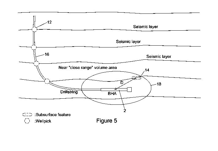
Figure 5 shows the definition of well picks and formation structures;
Figure 6 shows a Situation 1, and is a Seismic data section where we have
drilled a
well path shown by a solid white line;
Figure 7 shows a Situation 2, and is a Seismic data section where we have
drilled a
well path shown by a solid white line;
Figure 8 shows two uncertainty maps which represent the depth uncertainty for
the top
of the hydrocarbon reservoir;
Figure 9 shows an example of a covariance matrix of two points, a well pick
and a
seismic point; and
Figure 10 shows an example of a covariance matrix of two statistically
independent
points
DESCRIPTION OF PREFERRED EMBODIMENTS
CA 03038911 2019-03-29
WO 2018/063000
PCT/N02017/050244
3
Preferred embodiments will now be described, by way of example only, with
reference
to the accompanying drawings.
Each feature disclosed or illustrated in the present specification may be
incorporated in
the invention, whether alone or in any appropriate combination with any other
feature
disclosed or illustrated herein.
The starting point for the described embodiments is that the position of at
least one
point in the volume of the subsurface around the wellbore is measured by
different
types of instruments placed along the bottom hole assembly (BHA) in the
wellbore.
Examples of such measurements are deep azimuthal resistivity measurements,
ahead
of bit resistivity measurements, acoustic measurements, and neutron density
measurements. These instruments can measure contrasts in for example electric
resistivity which can correspond to for instance oil-water contacts, the top
of
hydrocarbon reservoirs, and interfaces between different rock types. Moreover,
the
positions of formation structures in a subsurface area covering the wellbore
are
measured via seismic surveys. Formation structures penetrated by the wellbore
are
measured and interpreted, and may also have been measured for other wellbores
in
the subsurface area. These measurements are called "well picks".
Therefore at least three type of measurement may be used, namely in-well
measurements around the wellbore, out-of-well seismic measurements, and well
picks.
Well picks, subsurface features and near wellbore volume measurements are
defined
in Figure 5. A well pick is identified by the log when the BHA is penetrating
the layer.
The absolute position of the borehole (measured by the Measurement While
Drilling
(MWD) directional survey instrument) is assigned to the well pick. A
subsurface feature
is a structure which could be e.g. a geological formation, fault, structural
surface or fluid
contact or any interfacing surface or line between two consecutive seismic
layers, is
identified within a limited volume around the BHA in the wellbore. The
direction and
distance from the BHA to the subsurface feature are calculated from the near
volume
measurements performed by the various sensors in the BHA.
CA 03038911 2019-03-29
WO 2018/063000
PCT/N02017/050244
4
An acoustic velocity model describes the velocity of the seismic wave
propagation
within the subsurface which can be used as a scaling factor in order to take
time data
derived from seismic data and scale it into depth.
Assume that we have an acoustic velocity model available for the formation
structures
in the subsurface area. The velocities can be obtained using the relationship
between
time and depth (V=D/T) with the depth (D) as the geological well observations
and the
time (T) as the seismic interpretation. Assume that we have a seismic depth
model
available. A depth model describes the end results after converting time
derived
subsurface seismic data using an acoustic velocity model to the estimated
depth of
subsurface seismic data. A depth model is a collection of the coordinates and
corresponding uncertainties of the subsurface structures. Assume that we also
have
available the measurements in the volume around the wellbore along with
uncertainties
of these measurements, and the well picks with uncertainties in three spatial
dimensions. The uncertainties (statistical properties) of every spatial point
in the depth
model are represented by a covariance matrix. The covariance matrix consists
of
variances on the diagonal elements, and covariances on the off-diagonal
elements.
Covariances describe the statistical dependencies between coordinates.
Similarly, the
statistical dependencies between coordinates of spatial points (being a
seismic point, a
well pick, or a point measured in the volume around the wellbore) are
expressed in
terms of covariances of a joint covariance matrix. Figure 9 shows an example
of such a
joint covariance matrix for two spatial points, in this case a well pick and a
seismic
point.
We first make some comments relating to the directional surveys of the
wellbore. The
basic measurements are the length along the wellbore from a reference point at
the
surface, and the two directional components called inclination and azimuth.
The
inclination is defined as the deflection of the wellbore axis with respect to
the gravity
field vector, while the azimuth is the direction in the horizon plane with
respect to north.
A common method for measuring the direction of the wellbore is to use a
magnetic
MWD survey instrument. Such an instrument consists of accelerometers and
magnetometers which measure components of the Earth's gravity field and the
Earth's
magnetic field, respectively. The accelerometer measurements are used to
determine
the inclination of the wellbore, whereas the azimuth is determined from the
CA 03038911 2019-03-29
WO 2018/063000
PCT/N02017/050244
magnetometer measurements. The position of the wellbore is a function of
inclination,
azimuth and the length of the drillstring from a surface reference point.
A novel aspect of embodiments is to update the depth model and the
corresponding full
5 covariance matrix with interpreted structural information up to 3D
directional and
distance measurements (and corresponding statistical properties) in the near
volume
around the wellbore, such as resistivity measurements. A measurement of a
point in
the near volume around the wellbore with sensors in the BHA is illustrated in
Figure 5.
The uncertainties of near volume measurements can be stipulated prior to
drilling
based on sensor specific error models, or estimated as a by-product of the
least
squares estimation approach.
We start by identifying one or more points of measurement in the near volume
around
the wellbore which correspond to one or more subsurface features in the depth
model.
The points can for example be interpreted from an image reflecting the
electric
resistivity of the volume surrounding the probing device. These points may be
assigned
with up to three dimensional spatial coordinates. The coordinates of such a
point are
estimated by using the survey of the wellbore as a reference combined with the
resistivity model to find the relative distance and direction from a well
reference point
(determined from the above-mentioned survey of the wellbore) to the
interpreted point
(corresponding with a subsurface feature). Each such point must be assigned
with
statistical properties, reflected in a point covariance matrix. This
covariance matrix may
be obtained by applying the law of covariance propagation on the three
available types
of positional information; the survey of the wellbore, the resistivity model,
and the
interpretation of the subsurface feature from the resistivity model. The
measurements
in the volume around the wellbore could be a collection of points which
resembles a
line or surface. In such a collection of points each point would potentially
be correlated
with all the other points. The correlation between points can be modeled by a
joint
covariance matrix for all consecutive points in the near wellbore volume. This
joint
covariance matrix may be obtained by applying the law of covariance
propagation on
the three available types of positional information described above.
All the available positional information (such as coordinates of well picks,
coordinates
of seismic points, coordinates of wellbore reference points and near wellbore
volume
measurements) may be mutually statistically dependent. Such types of
correlations can
CA 03038911 2019-03-29
WO 2018/063000
PCT/N02017/050244
6
be expressed by covariance components in a joint covariance matrix. This joint
prior
covariance matrix may be obtained by applying the law of covariance
propagation on
available types of positional information.
The measured points in the near volume around the wellbore and well picks can
be tied
to the seismic depth model through constraining equations. A constraining
equation
expresses mathematically how the coordinates of points are related, e.g. that
the
coordinates of a point measured from the wellbore (being either a well-pick or
a near
volume measurement) are equal to or differ with a certain defined distance
from the
corresponding point in the seismic depth model. The most probable positions of
all the
points in the depth model with corresponding statistical properties (which may
be
expressed by a covariance matrix) are calculated based on this redundant
measurement information (using for instance a least squares estimation
approach such
as the one described in the patent EP1306694 by Torgeir Torkildsen). A least
squares
estimation approach may be applied for this purpose. In such a way the prior
positional
information is adjusted correctly based on its prior positional statistical
properties.
The procedure of tying points measured from the wellbore with the seismic
depth
model may be summarized by the following steps:
1. Gather prior positional information including prior covariance matrices
2. Define constraining equations to tie together positional information
3. Adjust the positional information and the joint covariance matrix based on
introducing constraining equations and the method of least squares
The result is a depth model with statistical properties which are correctly
adjusted
based on all available positional information with corresponding statistical
properties.
This result may be applied to adjust the resistivity model accordingly and
prepare for
new measurements in the near wellbore volume. The overall workflow describing
the
preferred embodiment is shown in Figure 1. The novel element of including
measurements with corresponding uncertainties and correlations from the volume
surrounding the wellbore measured from the wellbore with deep azimuthal
resistivity
measurements as an example are described in the figures below.
CA 03038911 2019-03-29
WO 2018/063000
PCT/N02017/050244
7
Figure 2 shows a Bottom Hole Assembly (BHA) 2 with EM-sensors 4 seen from the
side. When the distance is measured from several discrete positions (survey
points)
along the wellpath the position of the geological feature 6 can be calculated
using e.g.
trilateration techniques. When directional measurements are available in
addition to
distances, 3D triangulation adjustment techniques can be applied. The figure
shows an
example where the EM sensor package 4 measures the 3D distance and 3D
direction
to a certain geological feature 6 (horizon surface etc.). From these
measurements the
3D position of the geological feature 6 is determined. The 3D position of the
geological
feature 6 can be calculated with respect to a local BHA-based coordinate
system, or
represented by North, East and True Vertical Depth (TVD) coordinates.
Based on accelerometer and magnetometer sensors in the Measurement While
Drilling
(MWD) survey package it is possible to determine the orientation of the BHA
(including
the EM sensor package) with respect to a global North, East and TVD coordinate
system. It will then be possible to transform between coordinates in the local
BHA-
based coordinate system and the global North, East and TVD coordinate system.
Figure 3 shows the same situation as shown in Figure 2 but where the BHA 2 is
seen
in a horizontal / lateral plane (from the vertical axis).
Figure 4 shows an example where the EM sensors 4 measure the vertical distance
to a
geological feature 6. The same geological feature (shown by the dashed line 8)
is also
determined based on seismic data only 8. This surface has high uncertainty due
to the
relatively poor seismic accuracy. The measured distance (D) ties together the
vertical
position of the BHA 2 and the vertical position of the geological feature 6.
The accuracy
of the measured distance defines the stringency of this constraint. Because
the position
of the BHA 2 has significantly better accuracy than the initial position of
the geological
feature 8 (determined by using the prior time and velocity input to the
model), the
adjusted vertical position of the surface (solid line 10) will end up closer
to the initial
vertical position of the geological feature 6 that was originally measured by
the EM tool
4. The result is an adjusted geological surface with improved TVD accuracy.
Relevant software for this application are
= Software for processing of resistivity data and presenting resistivity
images for
interpretation. Examples are AziTrakTm deep azimuthal resistivity measurement
tool
CA 03038911 2019-03-29
WO 2018/063000
PCT/N02017/050244
8
from Baker Hughes which allows for geo-steering and software for
electromagnetic
look-ahead EMLA developed by Schlumberger and Statoil
= Geo-modelling software such as Landmark DecisionSpace Desktop and Petrel
from Schlumberger
= Seismic depth conversion tools such as Paradigm Explorer, COHIBA from
Roxar, and EasyDC.
= Landmark Compass software tool for well path positional uncertainty
estimation
= PinPoint (Statoil internal)
Applications of the methods described will now be described.
The updated structural model can be applied to optimize the position of the
drill bit in
the pay-zone (i.e. the region producing hydrocarbons) in a while-drilling
situation. This
model can by updated in real time by using the new data collected during
drilling. The
model can be updated by recursive (e.g. by the method of least squares)
estimation for
instance to save computation time. If the model is updated by recursive
estimation, the
contributions from the new measurements to the prior positions of the
structures are
calculated using e.g. Kalman Filtering or similar recursive estimation
approaches.
Moreover, the updated model may be applied in the well planning phase for new
wells
in the region to provide more optimal well path placements for these. Finally,
the
updated model may be applied post drilling for creating a better understanding
of the
reservoir situation around the well, to optimize production in the production
phase.
Figure 5 shows the definition of well picks 12, subsurface features 14 and
near
wellbore volume measurements. A well pick 12 is identified by the log when the
BHA 2
is penetrating a layer. The absolute position of the borehole 16 (measured by
the MWD
directional survey instrument) is assigned to the well pick 12. A subsurface
feature 14
is identified within a limited volume 18 around the BHA 2 in the wellbore 16.
The
direction and distance from the BHA 2 to the subsurface feature 14 are
calculated from
the near volume measurements performed by the various sensors in the BHA 2,
for
instance one or more resistivity sensors distributed along the BHA 2.
Figure 6 shows a Situation 1, and is a Seismic data section where we have
drilled a
well path 20 shown by a solid white line. The black line is a seismic horizon
22 which
represents the seismic interpretation of the top of a hydrocarbon reservoir.
We have
CA 03038911 2019-03-29
WO 2018/063000
PCT/N02017/050244
9
not utilized any electric resistivity measurements in this situation but we
have calibrated
the seismic horizon to the drilled well picks, represented by the black
markers 24. In
this example, we have a lot of uncertainty regarding the geometry and
topography of
the top of the hydrocarbon reservoir (black line) between the well pick
markers 24. The
depth of the top of the reservoir is uncertain and we risk missing out on
potential
volumes if we need to sidetrack (drill to the side of the well path) or drill
another well in
the area.
Figure 7: shows a Situation 2, and is a Seismic section where we have drilled
a well
path 26 shown by a white line and a seismic interpretation 28 shown by a black
line.
The white dotted lines 30 represent the theoretical depth range of penetration
for EM
deep resistivity measurements (+- 10 m). The white markers 32 represent the
detection
of the top reservoir from the deep resistivity measurements. The black markers
34
represent the drilled well picks. We have calibrated the seismic horizon 28 to
the white
markers 32 and the black markers 34. The markers, interpretation and the well
survey
all have an associated uncertainty which are algebraically combined to give an
up to
date overall position and uncertainty of the top reservoir surface. In this
example, we
have an updated top reservoir depth surface which can be used to optimize the
position of a well plan in a drilling situation and can also be used post
drilling in order to
constrain volumes and optimize production.
Figure 8 shows two uncertainty maps which represent the depth uncertainty for
the top
of the hydrocarbon reservoir. A drilled well is represented by a white dotted
line 36.
The black markers 38 represent geological well observations for the top of the
hydrocarbon reservoir and the white markers 40 represent deep resistivity well
observations for the top of the hydrocarbon reservoir. The figure to the left
can be
directly comparable to the situation shown in Figure 6 which has not used the
deep
resistivity readings. Imagine we have to drill a new well at a reservoir
target
represented by the black star 42. Without using any deep resistivity
observations, we
would have an uncertainty of +- 20m at 2 standard deviations.
The figure to the right is now integrating both the drilled geological well
observations
and the deep resistivity well observations. This corresponds to the situation
shown in
Figure 7. Now we have an optimized surface which will reduce the uncertainties
to 12m
at 2 standard deviations at the black star target location 42.
CA 03038911 2019-03-29
WO 2018/063000
PCT/N02017/050244
Figure 9 shows an example of a joint covariance matrix 44 of two points in 3D,
a well
pick (represented by WP1 in the matrix) and a seismic point (represented by
SP1 in the
matrix). The statistical dependencies between the coordinates of the well pick
and the
coordinates of the seismic point are described by the 3 times 3 matrices in
the upper
5 right and lower left corners, respectively. The 3 times 3 matrices in the
upper left and
lower right corner are the covariance matrices of the well pick and seismic
point
respectively. The diagonal elements of the joint covariance matrix are the
variances of
the coordinates of the well pick and seismic point.
10 Figure 10 shows an example where the well pick and seismic point are
statistically
independent. This is expressed through zero covariances between the
coordinates of
the well pick and the coordinates of the seismic point.
Figure 11 shows a computing device 60, which may for example be a personal
computer (PC), on which methods described herein can be carried out. The
computing
device 60 comprises a display 62 for displaying information, a processor 64, a
memory
68 and an input device 70 for allowing information to be input to the
computing device.
The input device 70 may for example include a connection to other computers or
to
computer readable media, and may also include a mouse or keyboard for allowing
a
user to enter information. These elements are connected by a bus 72 via which
information is exchanged between the components.
It should be appreciated that any of the methods described herein may also
include the
step of acquiring data, including seismic and/or electromagnetic data, which
may then
be processed in accordance with the method.
The methods described herein of calculating the likely positions of structures
in a
region of the earth's crust may be used in a method of performing a survey, in
a
method of extracting hydrocarbons from a subsurface region of the earth, and
in a
method of drilling a wellbore in a subsurface region of the earth.
Instructions for
performing said methods described herein may be stored on a computer readable
medium, and said methods may be performed on a programmed computer.