Note : Les descriptions sont présentées dans la langue officielle dans laquelle elles ont été soumises.
1
RELATIVE POSITION NAVIGATION SYSTEM FOR MULTIPLE
MOVING VEHICLES
CROSS-REFERENCE TO RELATED APPLICATIONS
The present application is related to United States Patent Application Serial
No.
11/520,212, which was filed on September 13, 2006, issued as United States
Patent No.
8,949,011 on February 3, 2015 by Tom Ford, et al. for a HELICOPTER SHIP BOARD
LANDING SYSTEM and United States Provisional Application Serial No.
60/716,897,
filed on September 14, 2005, the contents of both are hereby incorporated by
reference.
BACKGROUND
Technical Field
This invention relates to the navigation of one moving vehicle relative to
another
moving vehicle.
Background Information
The relative position, velocity, and when appropriate, attitude of moving
vehicles
is important for operations in which two or more moving vehicles cooperate
with one
another, such as, for example, a shipboard landing of aircraft. United States
Patent No.
8,949,011, which is assigned to a common Assignee and incorporated herein in
its
entirety by reference, describes a system for accurately positioning an
aircraft, e.g., a
CA 30397002019-04-09
2
helicopter, relative to a designated location, e.g., a landing pad, on a ship.
The system
uses information from GNSS/INS systems on the respective moving vehicles to
determine a linking vector, and then uses a modified RTK procedure to
calculate an
associated post update correction that is applied to the aircraft INS position
in order to
produce an accurate relative position of the aircraft.
The post update correction is applied to the aircraft INS position between
updates
that occur at GNSS measurement epochs, which are the times when the positions
of the
moving vehicles are known using GNSS satellite signals. The aircraft INS and
the ship
INS are assumed to have similar errors over the GNSS measurement intervals,
and thus,
the relative position is accurately determined based on the INS information of
the aircraft
over the measurement interval. The system works very well to produce accurate
relative
positions at the IMU output rate, e.g., 100Hz.
However, it is desirous to have more accurate relative position information
that
may be used for the shipboard landing, as well as for other operations in
which accurate
relative position information is desired, such as, in air refueling of
aircraft, automated
harvesting of farm produce, automated vehicle convoys utilized in, for
example, mining,
and so forth.
SUMMARY
Embodiments of the present invention make use of a relative navigation system
consisting of a pair of Global Navigation Satellite System (GNSS) and Inertial
Navigation System (INS) units that communicate to provide updated position,
velocity
CA 30397002019-04-09
3
and attitude information from a master to a rover. The rover unit produces a
carrier based
solution that enables the system to reduce the uncorrelated low latency
position error
between the master and the rover units to less than 50 cm. The GNSS/INS unit
at the
master, such as, for example, a ship-based unit, provides the full position,
velocity,
attitude (PVA) solution, including GNSS observations, pseudorange and carrier
measurements. Further, the master unit provides the position of an eccentric
point, e.g., a
landing pad, to the rover-based unit. The rover-based unit generates a precise
carrier-
based vector between its own antenna and the GNSS antenna of the master unit
and uses
this to compute a GNSS position that has a high accuracy relative to the GNSS
antenna
on the master. This is used to update an inertial guidance unit in the rover
so that a low-
latency position can be generated by the rover unit. Further, by having the
full master
PVA solution, the rover may estimate the dynamics experienced at the master by
extrapolation based on PVA solutions over multiple measurement intervals, such
that the
rover unit adjusts the relative positions and thus the correction applied to
the rover
solution between measurement times to provide greater accuracy at higher
rates.
More specifically, in between the matched observations, the rover unit
propagates
the position, velocity and attitude over a measurement interval based on
constant velocity
rotation rate models of the movement of the master. This allows the rover to
generate
relative solutions at rates that coincide with INS sensor readings, e.g., 200
Hz. Further,
with the rover having all of the PVA solution information about the master,
the relative
position information may be rotated to various frames such as, for example,
local level,
Earth Centered-Earth Fixed (ECEF), remote body frame, master body frame, and
the
CA 3039700 2019-04-09
4
system can thus provide the relative position information in a format that is
the most
useful to the user or to cooperating instrumentation.
BRIEF DESCRIPTION OF THE DRAWINGS
The description below refers to the accompanying drawings, of which:
Fig. 1 is a diagram of a system for landing an aircraft on the deck of a
vessel in
accordance with an illustrative embodiment of the present invention;
Fig. 2 is a diagram of a ship-board navigation unit used in the system of Fig.
1 in
accordance with an illustrative embodiment of the present invention;
Fig. 3 is a diagram of a navigation unit carried on the aircraft for use in
the system
of Fig. 1 in accordance with an illustrative embodiment of the present
invention; and
Fig. 4 is a flowchart detailing a procedure for relative position navigation
in
accordance with an illustrative embodiment of the present invention.
DETAILED DESCRIPTION OF AN ILLUSTRATIVE
EMBODIMENT
Referring now to Fig 1, the navigation system includes of a pair of GNSS/INS
navigation units, one on a master, for example, a ship and one on a rover, for
example, a
helicopter. Each GNSS/INS unit generates continuous PVA information at the INS
output rate, e.g., 200Hz. The units may also apply an eccentric offset to the
position
information, such as an aircraft landing pad, at the same rate. The INS errors
are
CA 3039700 2019-04-09
=
controlled with GNSS positions that can be either single point, differentially
corrected,
PPP (Precise Point Positioning), or derived from the receiver's RTK (Real Time
Kinematics) process. In an environment in which there is no stationary base
station from
which differential corrections can be generated, that is, in which the master
is moving
independently from the rover, the controlling positions are inertial
transferred with a
precise baseline vector. In order to obtain an accurate translation vector, an
RTK
baseline is determined between the GNSS antennas on the moving master and
moving
rover.
Typically, the RTK process expects pseudorange and carrier measurements that
have been observed at a stationary base station receiver. Since the base
station is
stationary, its carrier observations can be easily modeled to provide the
remote receiver
with the capability of generating high rate low latency RTK positions. If the
base station,
here the master, is moving, the observations cannot be effectively modeled,
but as
discussed below, the measurements taken at the master can be combined with the
rover
receiver observations to generate low-rate higher latency RTK positions.
The RTK translation vector is applied to the filtered INS estimate of the
master
antenna position. This is a noise-reduced position with some coloring on the
position
errors, and the remote INS on the rover does not have to track high-frequency
errors.
Instead, the object is to weight the controlling (translated) positions at the
rover's
GNSS/INS unit such that the resulting filtered INS positions have the same
error
characteristics as at the moving master unit. In this way the positions at the
two locations
will be accurate relative to one another.
CA 3039700 2019-04-09
6
The system illustratively reduces the relative error from the level dictated
by the
two inertial systems. The inertial errors at both systems are slowly varying
(typically at a
rate less than a few centimeters per second), and therefore the relative error
between the
two systems is also slowly varying. Accordingly, the positions measured after
the inertial
update, can be used to remove the bulk of the relative error over a small (one
second)
interval to follow. In order to do this, the post update remote position is
differenced with
the master post update position and the resulting vector is differenced from
the RTK
moving baseline vector to obtain a post update inertial position correction.
This
correction is applied to the inertial output at the rover system. As discussed
in more
detail below, the inertial position correction is updated between measurements
to improve
accuracy.
To reiterate, the post-update position difference is subtracted from the
computed
RTK vector to form a post-update position correction. The correction is added
to the
inertial positions at the rover after they have been generated by the inertial
system (raw
measurements converted to the ECEF frame and integrated to generate velocity
and
position). Thus, corrections are not used to modify the position of the
inertial system, but
only the output of the inertial system.
The method used to generate the accurate linking vector involves using the
carrier
measurements from the two GNSS receivers in a modified RTK algorithm. The RTK
algorithm solves for the carrier ambiguities of the double differenced carrier
measurements collected at the two GNSS receivers. It produces a vector that
has a
typical accuracy of 2 cm, linking the two GNSS antennas used to collect the
carrier
measurements.
CA 3039700 2019-04-09
7
Usually the stationary receiver (the base) transmits its position and carrier
measurements to the moving receiver (the rover). The rover matches the
transmitted
carrier measurements with its measured carrier measurements and uses these to
compute
the baseline vector. Once this is generated, the vector is added to the
transmitted base
station position to produce a position with excellent accuracy relative to the
moving base
station position. However, because both the master and the rover receivers are
moving,
the only reliable vector available coincides with the even second mark at
which time
actual measurements from both receivers are available. Thus, the position used
to update
the rover Kalman filter has some latency associated with it, and the timing of
the inertial
Kalman update at the rover system is slightly delayed to accommodate this
latency. In
addition, the timing used to generate the updated rover position (master plus
vector) is
such as to ensure that both quantities (master position and linking vector)
have the same
time tag.
For a normal RTK system that has a stationary base station, the base position
is
transmitted at a low rate, for example, once every 30 seconds or so. The
transmitted
position is usually entered as a "fixed" position in the base receiver. In the
system with
two moving units, the master station position transmitted is the filtered
inertial position
controlled by a single point GNSS. It is transmitted at times associated with
GNSS
measurements, e.g., 1Hz.
The improvement further utilizes extrapolated position and velocity and, as
appropriate, attitude information relating to the master to update the
inertial position
correction, such that the corrections more accurately reflect the expected
movement of
the master during the measurement interval.
CA 3039700 2019-04-09
8
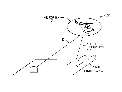
As shown in Fig. 1, the invention relates to the positioning of a rover
vehicle, here
an aircraft 105, such as, e.g., a helicopter, for landing on a designated pad
115 on the
deck 110 of a master vehicle, here a sea going vessel. Both the master and the
rover have
navigation units described herein and they are provided with a wireless link
120 for
transmission of data from the master to the rover.
With reference to Fig. 2, the master carries a GNSS / INS navigation unit
comprising a GNSS antenna 205, a GNSS receiver 210, an inertial navigation
unit (INU)
235, a computer 215, an RTK transmitter 240, and an antenna 245.
Illustratively, the
computer comprises of a processor 220 and memory 225 that stores software 230
to be
executed by the processor 220. The GNSS receiver 210 provides position
readings but at
a rate that is too low for the operations contemplated by the invention. These
readings
are used by the processor 220 to update the INU 235, which is subject to long
term drift
but provides position data at a relatively high rate. An arrangement for
integrating an
INS with a GNSS receiver is described in "OEM4 Inertial: An Inertial/GNSS
Navigation
System on the OEM4 Receiver", Proceedings of the International Symposium on
Kinematic Systems in Geodesy, Geomatics and Navigation (KIS), Banff, Alberta,
September 2001, by Ford et al, the contents of which are hereby incorporated
by
reference. GNSS RTK (Real Time Kinematics) information and INU 235 readings
are
transmitted to the aircraft over the wireless link 120.
With reference next to Fig. 3, the master 110 carries a GNSS / INS navigation
unit comprising a GNSS antenna 305, a GNSS receiver 310, an INU 335, a
computer
315, an RTK receiver 340, and an antenna 345. The computer 315 illustratively
comprises a processor 320 and a memory 325 that stores a modeling subsystem
330 to be
CA 3039700 2019-04-09
9
executed by the processor 320. The processor 320 uses the usual RTK procedures
to
enhance the position data provided by the GNSS receiver 310 and to compute a
vector
125 to the shipboard GNSS antenna 305. In turn, the processor updates the INU
335
periodically with the enhanced GNSS data. Although the relative accuracy of
the update
position at the remote is accurate to within 1 to 2 centimeters (typically),
the absolute
accuracy of the update position at the remote has an accuracy of just 1 to 2
meters. This is
reflected in the variance of the position used in the Kalman update. The
output position of
the inertial system at the remote is then modified by a post-update position
correction that
restores the relative accuracy between the two moving systems to the
centimeter level.
=The correction is computed by differencing the post-update master position
and the post-
update rover position and subtracting this difference from the RTK vector used
to
generate the pre-update rover position.
With this arrangement, the RTK corrections to the GNSS position of the
aircraft
provide the aircraft with an accurate position relative to the ship's GNSS
antenna.
Accordingly the aircraft pilot (or a servo system controlling the aircraft),
by virtue of the
comparison of the INU 335 position data on the aircraft and the INU 235 data
transmitted
to the aircraft, has an accurate, low-latency distance from and bearing to the
antenna 305
on the ship. The ship also calculates the parameters of a vector from the GNSS
antenna
305 to the landing pad 115. The aircraft uses this information, which is
transmitted over
the wireless link, to provide the aircraft with a vector to the landing pad
115.
As discussed, the master may be, for example, another aircraft, a land
vehicle, a
vehicle that is part of a convoy, and so forth, and the rover may be, for
example, an
aircraft, another land vehicle, another vehicle in the convoy, and so forth.
CA 3039700 2019-04-09
10
Between GNSS measurement epoch updates, the modeling subsystem 330
provides to the processor 320 the result of applying a constant
acceleration/rotation
model to the master PVA solution, to propagate position, velocity and attitude
of the
master. This allows the system to then generate corrections for the relative
expected
master and sensed rover solutions at rates higher than the matched observation
rate.
The rover estimates the dynamics experienced at the master by extrapolating
from
the last two solutions.
Avrito = "14
Adtito = ¨ 41)
Assuming the rates computed remain constant until the next received solution
(i.e., t2), the master solution is adjusted to the output time, tn, as
follows.
( Wilt (tn ¨ t1)2
¨ tO
p tmn = 7411 + ( v ) ( t n ¨ t1) +
2.0
ii -L ri
Avto
m tl ¨ tO (tn ¨ t1)
vtn tl '
n om
Aa7tito (tn ¨ t1)
"tn "tl
Following the adjustment of the master PVA solution, a high rate relative
solution
can be computed at the rover, without needing high rate data from the master.
APlin m = Ptmn
vrnm = vTn ¨ vg/
CA 3039700 2019-04-09
' . .
11
Act it-TT- = alin ¨ alt7,2,
The relative solution can be rotated to various output frames by computing the
corresponding rotation matrix. The master transmits the PVA solution in the
local level
frame. Therefore, if the output frame is also local level no rotation is
required. If the
output frame is selected to be ECEF, the current local level solution can be
rotated using
the following rotation matrix.
[¨sin A ¨ sin co cos A cos cio cos A
Rt = cos A ¨ sin cp sin A cos cio sin A
0.0 cos cp sin cp
Where,
cp ¨ latitude
A ¨ longitude
If the output frame is selected to be Master/Remote body fame, the current
local
level solution can be rotated using the attitude of the Master/Remote by
computing the
following rotation matrix.
cos y cos /3 ¨ sin y sin a sin )6' sin y cos ig + cos y sin a sin /3 ¨ cos a
sin if?
RP = ¨ siny cos a cosy cos a
sin a
cos y sinfl + sin y sin a cos )3 sin y sinfl ¨ cos y sin a cos fi'
cos a cos fi
Where,
'
a ¨ pitch of the reference frame
ll CA 30397002019-04-09
=
12
¨ roll of the reference frame
y ¨ yaw of the reference frame
As discussed, the system's rotation of the relative position information
provides
the information to a user on other instrumentation in a format that is useful
to them. For
example, other area GNSS receivers may require the information in ECEF format.
The
master may broadcast its PVA solution to multiple rovers, and the rovers may
then
determine their position relative to the master or a particular location on
the master. For
example, in a convoy the master may determine the positions relative to a
front corner of
the master vehicle. The various vehicles may then operate to maintain desired
positional
relationship with the moving master, to ensure the convoy moves in a desired
manner.
Similarly, landing aircraft may determine their positions relative to a
landing pad in order
to operate in an orderly and efficient landing scenario.
Fig. 4 is a flowchart detailing the steps of a procedure 400 for relative
position
navigation in accordance with an illustrative embodiment of the present
invention. The
procedure 400 begins in step 405 and continues to step 410 where the GNSS/INS
unit at
the master, such as, for example, a ship-based unit, provides the full
position, velocity,
attitude (PVA) solution, including GNSS observations, pseudorange and carrier
measurements. The master then transmits the full PVA solution as well as the
position
of an eccentric point, e.g., a landing pad, to the rover in step 415. Then, in
step 420, the
rover-based unit generates a precise carrier-based vector between its own
antenna and the
GNSS antenna of the master unit and uses this to compute a GNSS position that
has a
high accuracy relative to the GNSS antenna on the master. This GNSS position
is used to
CA 3039700 2019-04-09
13
update an inertial guidance unit in the rover so that a low-latency position
can be
generated by the rover unit in step 425. In step 430, in between the matched
observations,
the rover unit propagates the position, velocity and attitude over a
measurement interval
based on constant velocity rotation rate models of the movement of the master.
This
allows the rover to generate relative solutions at rates that coincide with
INS sensor
readings, e.g., 200Hz. More generally, by having the full master PVA solution,
the rover
estimates the dynamics experienced at the master by extrapolation based on PVA
solutions over multiple measurement intervals, such that the rover unit
adjusts the relative
positions and thus the correction applied to the rover solution between
measurement
times to provide greater accuracy at higher rates. The procedure 400 then
completes in
step 435.
While various embodiments have been described herein, it should be noted that
the
principles of the present invention may be utilized with numerous variations
while keeping
with the spirit and scope of the disclosure. Thus, the examples should not be
viewed as
limited but should be taken as way of example.
CA 3039700 2019-04-09