Note: Descriptions are shown in the official language in which they were submitted.
1 338747
I~ACKGROUND OF 'l'l~E INVENTION
The present invention relates to automatic landing of
aircraft with the help of a special-purpose electrooptical
sensor.
Landing of aircraft in general, and of RPV in particular, is
the most difficult step in the operation of aircraft. lt requires
l1ighly-skilled operators, involves non-negligible risk, and can
be performed only in favorable fligl1t condition6.
Currer1tly the RPVs are landed by human operator6 tl1at either
observe it from tlle land strip or monitor the picture transmitted
by a TV camera mounted on board. The guidance commands are radio
transmitted to the RPV. Lotl1 methods po6e considerable
difficulties since the pilot is put into unfavorable conditions
compared to the operation of ordinary aircraft and receives only
incomplete information. In particular, the pilot's perception of
the ~PV position is limited, he lacks 60me motion cues, is less
percipient of suddel1 disturbance6, etc. The ability to land the
~PV in adverse conditions sucl1 as bad weather, limited
visibility, or at night is severely limited.
Landing of manned aircraft on small air6trips such as
aircraft carriers present similar difficulties. The landing
platform is very small compared to the typical ground landing
~strip, so that very accurate guidance to the touch down point is
required. Tl1e pilot lacks a stationary reference like the horizon
_ 3 _ 1 338 74 7
or some terrain features; strong wind disturbances
are often encountered; the landing process is very
short and demands very quick response of the pilot
to correct the flight path deviations; and in rough
seas the landing platform is moving in six degrees
of freedom with considerable amplitude.
Various systems have been suggested for
automatic landing of aircraft. These systems use
the instrument measurement of the aircraft position
to keep it on the desired descent trajectory. The
measurements used are the readings of the on-board
instruments (e.g. altimeter, gyros, and
accelerometers), radar readings, or even special-
purpose ground-based sensors. The methods and
systems described in the literature are, however, of
limited nature since the measurement of the RPV
(remotely piloted vehicle) degrees of freedom is
incomplete and inaccurate.
In particular, Hornfeld et al,
"Automatically Landing an Aircraft", U.S. Patent No.
4,385,354, May 24, 1983, describe an automatic
landing system based on an additional optical
sensor. The system comprises a plurality of
infrared fires in a line which extends transversely
to the runway, whereby the central one is located at
the end of the runway, and an infrared TV camera
connected to a computer on board of the aircraft.
The camera (sensor) is continuously rotated in such
a way that the image of the central fire is obtained
in the center of the image plane; the angle of the
rotation of the camera is used to determine the
deviation of the aircraft relative to the centerline
1 338747
-- 4 --
of the runway. The system is supplemented by
additional sensing systems such as the laser range
finder to find the distance to the aircraft. This
method can, basically, be used only to guide the
aircraft along a predetermined straight path. The
measurement method of gimballing the camera and
using the TV tracker is incomplete and introduces
large measurement errors, which should prove
detrimental to proper guidance.
Other described systems Urness, J.M. and
R.K. Hess, "Development of the F/A-18A Automatic
Landing System", J. of Guidance Control and
Dynamics, Vol. 8, No. 3, May-June 1985 and Phillips,
C.L., R.F. Wilson, E.R. Graf and S.A. Starks,
"Observers as Noise Filters in an Automatic Landing
System", J. of Guidance Control and Dynamics, Vol.
6, No. 2, March-April 1983, use radar readings in
order to determine the direction and the distance to
the approaching aircraft. These systems suffer from
the drawbacks mentioned above: the measurements are
not accurate and incomplete (only the direction to
and the position of the aircraft is provided), and
the guidance to the landing is, necessarily,
restrictive. Systems of this kind are incapable of
providing tight landings, landings on limited
strips, or on medium- and small-size ships.
The existing automatic landing systems for
large commercial or military aircraft, on the other
hand, are very expensive and require extensive
installation on the landing site.
1 338747
SUMMARY OF TIIE INVENTION
The present invention relates to an automatic landing system
comprising light sources, an electrooptical 6ensor and a guidance
computer. The novelty of tl-e system is characterized by accurate
measurement of all the six degrees of freedom of the aircraft
(position and orientation) effected by a single and self-
contained sensor an~ 11 utilization of this information in
controlling the aircraft. On the basis of the measurements the
system evaluates the disturbing influence6 such as atmospheric
turbulence or wind gusts and takes tllem into account. ThiS allows
one guide the aircraft very accurately along the desired
trajectory and take any required corrective actions
instantaneously.
Amongst the significant advantages are the increased safety
of the aircraft and payload; the ability to make the landing very
soft (minimizing damage to payload) and very accurate (touch-down
in a precise spot); the ability to take full advantage of the
capacities of the aircraft by executing very complicated
maneuvers not available ordinarily to human operators, as a
consequence of whicll it is possible to minimize the size of the
required landing strip and minimize the time spent by the
aircraft above the airfield; high update rate, high accuracy, and
full computer control makes it possible to land on moving
platforms such as small sl~ips provided the information on the
6hip motion is supplied.
1 338747
In the preferred embodiment for small
unmanned aircraft, such as the majority of current
RPV's, the light sources are mounted on the aircraft
while the measurement, processing of information,
and computation of the guidance commands are
performed on the ground; the commands are
transmitted to the RPV through the radio link, as it
is done in the manual operation mode. This
embodiment is suggested as an add-on system designed
for minimum intervention with the manual operation
mode.
In the embodiment preferred for larger
aircraft the light sources are ground based while
the sensor and the processing of information is
performed on board of the aircraft. This extends
the operational range, since much more powerful
light sources can be used, and improves the overall
performance since the transmission time lags are
eliminated. An additional advantage is that the
airborne system becomes self-sufficient.
In accordance with a particular embodiment
of the invention there is provided an automatic
landing system for determining spacial position and
guidance of movement of an aircraft comprising:
a light emitter mountable on one of an
aircraft and ground station consisting of three
lights of preselected spectral band fixed in a
triangular optical relationship and receiver means
for receiving landing trajectory signals from the
other of an aircraft and a ground station;
a receiver mountable on the other of an
aircraft and ground station comprising an electro
optical sensor means including camera means having a
spectral filter matched to the spectral band of the
three lights for detecting light emanating from the
three lights and an iris for receiving light from
- 6a -
1 33~747
the spectral filter to regulate the intensity of the
light detected by the spectral filter, and lens
means for changing the field of view of the spectral
filter and iris, said camera means producing an
output signal correlated with light detected by the
spectral filter;
frame grabber means for receiving the
output signal from the camera means and providing an
outputi and
an image data processor receiving the
output of the frame grabber means for controlling
the iris and the lens means and for determining
relative position and orientation of the light
emitter in all six degrees of freedom based solely
on the light detected from the three lightsi
guidance means connected to the image data
processor for evaluating disturbances and
reconstructing a landing trajectory based upon
deviations from a desired optical landing trajectory
and for developing an output relative thereto; and
means responsive to the output of the
guidance means for guiding the aircraft to a desired
landing.
From a different aspect, and in accordance
with the invention, there is provided a system for
landing of aircraft, comprising in combination:
a. an arrangement of three light sources
defining a triangle;
b. electrooptical sensing means
comprising an area imaging device and an image
processing computer;
c. a guidance computer connected to the
image processing computer;
d. radio-communication means.
From a still further aspect, and in
accordance with a particular embodiment of the
1 338747
- 6b -
invention, there is provided an electrooptical
sensing means for accurate measurement of all six
degrees of freedom of a remote object based on three
light sources forming a triangle mounted on the
object, comprising a CCD (charged coupled device)
camera, a lens, and a computer for processing the
image information and calculating the coordinates on
the basis of the imaging equations.
From a still further aspect, and in
accordance with the invention, there is provided an
automatic landing system for determining spacial
position and guidance of movement of an aircraft
comprising:
a light emitter mountable on one of an
aircraft and ground station consisting of three
lights of preselected spectral band fixed in a
- 6c - 1 33~747
triangular optical relationship and receiver means
for receiving landing trajectory signals from the
other of an aircraft and a ground station;
a receiver mountable on the other of an
aircraft and ground station comprising an electro-
optical sensor means including camera means having a
spectral filter matched to the spectral band of the
three lights for detecting light emanating from the
three lights and an iris for receiving light from the
spectral filter to regulate the intensity of the
light detected by the spectral filter, and lens means
- for changing the field of view of the spectral filter
and iris, said camera means producing an output
signal correlated with light detected by the spectral
filter;
frame grabber means for receiving the
output signal from the camera means and providing an
output; and
an image data processor receiving the
output of the frame grabber means for controlling the
iris and the lens means and for determining relative
position and orientation of the light emitter in all
six degrees of freedom based solely on the light
detected from the three lights;
guidance means connected to the image data
processor for evaluating disturbances and
reconstructing a langing trajectory based upon
deviations from a desired optical landing trajectory
and for developing an output relative thereto; and
means responsive to the output of the
guidance means for guiding the aircraft to a desired
landing.
,~
. ~
~ 6d- 1 338 74 7
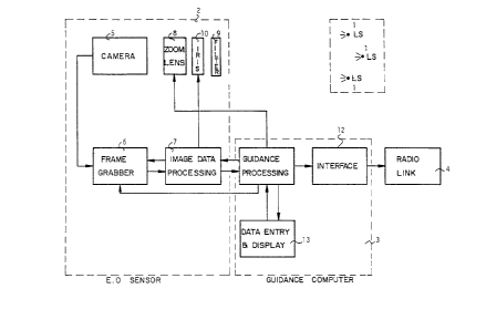
BRIEF DESCRIPTION OF DRAWINGS
Figure 1 is a block diagram of the aircraft
landing system in accordance with the invention;
Figure 2 illustrates the process of landing
an aircraft with the help of the inventive system;
Figure 3 illustrates the zoom lens imaging
geometry;
Figure 4 illustrates a preferred
configuration for RPV's; and
Figure 5 illustrates a preferred embodiment
for larger aircraft.
- 7 - 1 3 3 8 74 7
DETAILED DESCRIPTION OF THE INVENTION
The present invention relates to a method of guiding and
landing aircraft on the basis of accurate measurements of its
position and orientation, and to a system for such method. The
method is characterized by accurate measurement of all the six
degrees of freedom of the aircraft (position and orientation) and
\ full utilization of these in the landing algorithms. The general
block scheme of the automatic landing system is shown in Fig. 1.
The system comprises, in combination, light sources (1), an
electrooptical sensor ~2), a guidance computer ~3), and a radio
link ~4). The invention provides two types of configurations: (a)
light 60urces mounted on the aircraft with a ground-based 6ensor,
and (b) an airborne sensor with ground-based light sources, with
necessary auxiliary equipment.
The light 60urce6 comprise at least three point sources of
light (LS) mounted to define a triangle, which must be powerful
enough to be detected from sufficiently large distances by the
electrooptical sensor.
According to preferred embodiments, the electrooptical sen60r
~1) comprises a high-resolution area CCD camera (5) and a
frame-grabbing card (6) connected to an image data processing
computer (7), such as a general-purpose microcomputer or a
special card embedded in a larger computer. Such a camera is
equipped with a lens (8) providing one or more fields of view, a
spectral filter (9), and an autoiris ~10). The spectral filter
1 3 3 8 7 4 7
(9) is matched to the spectral band of the light sources (1)
employed in order to improve the signal-to-noi6e and the
signal-to-background ratios. The computer-controlled autoiris
(10) regulates the received signal who6e intensity increases
considerably with the approach of the aircraft.
The provision of 6everal field6 of view of 6uch a sy6tem can
be effected by using an appropriate changeable-focus len6 (8), or
by using 6everal cameras (5) each with a different lens,
connected to the same computer.
~- The image information received by the camera (5) through the
frame-grabbing card (6) is processed by the computer (7) in order
to determine the coordinates of the image6 of the light 60urces;
subpixel interpolation is used in order to achieve maximum
resolution. The imaging equations are then 601ved and the
three-dimensional coordinates of the light source6 relative to
the 6en60r are determined. On the basi6 of the6e coordinate6 the
po6ition and orientation of the aircraft are determined. It i6 an
important feature of the 6ystem of the pre6ent invention, that it
is designed so as to achieve highly accurate mea6urement6 of the
all the 6ix degree6 of Ereedom of the aircraft.
The mea6urement6 of the position and orientation of the
aircraft, which can be sampled at the TV rate or at a higher
rate, are passed to the guidance computer (11). The computer u6es
filtering techniques based on the model of the aircraft dynamics
in order to recon6truct the aircraft tra~ectory and to evaluate
- ~ - 1 3 3 8 7 ~ 7
any di6turbances (such as wind gu~ts). The deviations from the
desired optimal landing traiectory are computed, and the
corresponding guidance commands are issued.
In the configuration with a ground-based 6ensor, the guidance 5 commands are transmitted to the aircraft by the radio link ~4)
through an appropriate interface (12). In the reverse
configuration, the radio link is used to transmit optional
information to the ground control station. Provision i8 made to
supply various technical data to the automatic landing system by
means of the terminal (13), such as the identification of the
type of the approaching aircraft, general weather conditions,
type of the desired landing tra~ectory, etc. The terminal (13) is
also to display back the flight information to the operators,
such as exact position of the aircraft, the aircraft speed and
sinking rate, any deviations from the landing trajectory, wind
and turbulence disturbance6 as measured by the sy6tem, and the
position of the expected touch down point. The terminal can also
used to transmit the abort command in unexpected emergency
situations.
The system is utilizing the existing autopilot systems of the
alrcraft, but is designed to fully replace same in various
failure modes or in the absence of the autopilot.
The process of landing aircraft with the help of the syste~
is depicted in Fig. 2. The aircraft (14) is brought to the
vicinity of the landing site by independent means, and is guided
' ' : .
" , . . :
- 10 ~ 1 338 74 7
into the acqui6ition box ~15) of the automatic landing 6ystem at
the maximum acquisition range. The acquisition range is defined
by the detectability of the light 60urce6 by the 6ystem, and the
dimensions of the acquisition box corre6pond to the field of
view. The acquisition range and the dimen6ion6 of the acqui6ition
box are designed in accordance with the size and type of the
aircraft, the independent navigation mean6 u6ed to guide the
aircraft into the acquisition box, and the 6pecifics of the
landing site. Typically, the 6ystem will function with two field6
of view, a wide field of view for the initial acquisition, and a
narrow field of view for accurate measurement. The system will
acquire the target in the wide field of view, where at large
distance only the measurement of the height and lateral
displacement are possible, and will guide it along the de6cent
trajectory (16) to the gliding slope (17) in the center of the
field of view, where it will switch to the narrow field of view.
once in the narrow field of view, accurate mea6urement6 of all
the six degrees of freedom are effected and the guidance of the
aircraft is changed accordingly. At very 6hort range6 the sy6tem
may 6witch again to the wide field of view 6ince in the narrow
field of view the 6ize of the image may become too large. The
system guides the the aircraft to the touch down point (18) and
full stopping of the aircraft, typically by the arresting cable
(19).
- 11 - 1 338747
During the guidance process the sy6tem e6timates constantly
the expected trajectory of the aircraft, which is calculated so
as to be the closest to the optimal landing trajectory given the
actual disturbances, and calculates the position of the expected
touch down point as well as the aircraft speed and sinking
velocity. In the case where any of these critical parameter6
exceed the allowed limits, or if an emergence abort command is
received from the human operators, the sy6tem aborts the mis6ion
and commands the autopilot of the aircraft to gain safe altitude
and transmit6 the control to the control station. Typically, the
aircraft will be made to complete a go-around circle around the
landing strip and will be brought again into the acquisition box
so that the automatic landing will be retried. The data entry and
display terminal (13) is designed in such a way that a human
operator can take over the control at any desired moment. The
terminal (13) is located inside the ground control station (22),
being connected to the electro-optical sensor (2) and the
guidance computer (3) by means of a connecting cable (23). The
data entry terminal (13) can by equlpped wlth a highest-priority
joystick for taking over the control by a human operator in
emergency situations.
The imaging geometry is shown in Fig. 3, where A, ~, and C
are the light sources and a, b, and c are their images in the
camera chip plane. Denoting by x~, y~, z~, ..., XC~ YC' ZC the
coordinates of the light sources, and denoting by y~, z~, ....
y~, z~ the coordinates of their image6, the imaging equations
_ 17 _ ~ 338747
read
Y - --f ~ b ~ ~p, c
Lo ~ _ f A Z6 - - f -- Ze - ~
where f is the focal length of the len6. On the other hand, the
three relative distances r~ ~ r~c~ and rAc between the light
60urces A, B, and C can also be expressed in terms of the
coordinate6:
r~C~ C- ~ C~ C~ZPa~2
r~C S ~ Cxc~ ' (YC- ~ Zc- Z~)~
The result is a system of nine equations for the nine unknown
coordinates of the light sources. Thi6 6ystem can be solved
knowing the coordinates of the light source images, provided the
light sources are not collinear. In the practical conditions
encountered in the operation of the automatic landing 6ystems,
the solution is unique. The coordinates of the images in the
camera chip plane are obtained by image proces6ing of the pixel
information. Namely, the video output of the camera is digitized
and stored in the computer memory with each number corresponding
to the light intensity in the appropriate picture element
(pixel). The plxels corresponding to the light source images are
detected by thresholding, and centroid interpolation is used for
-- 1 338747
- 13 -
determination of the image position. The inter-
polation results in superresolution - positional
resolution better than pixel size.
The critical system parameters are the
range, total field of view, and the measurement
accuracy. The former two parameters are a
consequence of the operational requirements of the
concrete application, viz., type of aircraft, size
and type of landing strip, operating conditions,
type and availability of independent navigational
means, etc. For the RPVs the typical range is 1 - 2
km, and the total field of view is of the order 20
degrees. The requirement of a certain measurement
accuracy is dictated by the considerations of the
guidance and control: the better the measurement
accuracy, the more reliable control. Simulation of
the RPV landing shows that a measurement accuracy of
~3 mrad is sufficient to achieve very reliable
control of the RPV and ensure very accurate landing.
The accuracy achievable in a concrete design is
mainly dependent on the range and field of view. In
order to achieve the required accuracy at large
ranges the system will typically employ a second
narrow field of view.
In the preferred configuration for RPVs,
shown in Fig. 4, the light sources (1~
are preferably powerful laser diodes mounted on
the RPV (20), and the sensor (2) and the computer
(3) are placed on the ground, at the end of the
landing strip (21) behind the arresting cable (19).
The diodes chosen were the 500 mW laser diodes
such as the SLD303 diodes of SONY (Registered
Trademark) operating in the continuous-wave mode,
and they were mounted on the nose and the wing
tips of the aircraft. The diodes were equipped with
- 14 - 1 3 3 8 74 7
cylindrical lenses in order to achieve an emis6ion angle of ~0 by
20 degree6; the CCD camera was Pulnix TM ~65 camera pos6essing
aoo by 590 photosensitive elements; the len6 wa6 capable of
providing two focal lengths, 35 mm and 170 mm, and wa6 equipped
6 with a computer-controlled autoiris; the frame grabber was the PC
Vision Plus card by Imaging Technologies Inc.,; and the data
proces6ing and the guidance computer was an I~M PC compatible.
The bandwidth of the spectral filter of the camera was matched to
the emi6sion wave length of the diode6. The diodes mounted on the
aircraft define a triangle with a 5 m ba6e and 2 m height. The
two focal lengths of the lens define the two fields of view, a
wide one, of 15 by 12 degree6, and a narrow one, of 2 by 3
degrees. The maximum range of the sy6tem i6, depending on the
atmospheric visibility conditions, 1500 - 2000 m, and the
measurement accuracy in the narrow field of view is of the order
3 mrad.
The 6y6tem acquires the target in the wide field of view at
the maximum range, with the aircraft flying horizontally towards
the sensor at a cruising altitude of, approximately, 300 m. Only
the mea6urement of the altitude and lateral po6ition of the RPV
are provided. On the basis of thi6 information, the RPV iB guided
down to the gliding slope to the center of the field of view.
Once thi6 i6 achieved, the sy6tem switche6 to the narrow field of
2~ view and start6 providing accurate mea6urement6 of all the 6ix-
degree6 of freedom. This transition occur6 at a di6tance of 1000
- 1500 m and altitude ~10Om. At a di6tance of 250 m the system
- 15 - 1 3 3 8 7 4 7
switches back to the wide field of view which is now sufficiently
accurate. The landing accuracy is better than l m laterally, 2 m
longitudinally, and 3 degrees in the roll and azimuth angles.
This configuration is designed as an add-on 6ystem for
minimum interference with the existing configuration of the RPV
and it6 mode of operation, and with the requirement of the
minimum additional weight and power demands on the aircraft. The
computer calculated guidance command6 are tran6mitted to the RPV
by a radio link (4) in place of the joystick command6 of
- the human operator.
\ In the preferred embodiment for larger aircraft, shown in
Fig. 5, where larger acquisition ranges are required and where
there i6 les6 emphasi6 on the minimum weight of airborne parts,
the light 60urce6~are based on the ground and the camera and the
computer are on board. Two of the pos6ible options are
specifically mentioned, (a) a configuration with three powerful
projectors (24) placed on the landing strip behind the arre6ting
cable and arranged in the triangle, and the airborne sen60r
equipped with two field6 of view, much like the configuration for
the RPV6 but in the reverse mode; and (b) a configuration with
additional two powerful projectors (25) placed 60 as to form an
additional extended triangle and to eliminate the need for two
field6 of view of the airborne sen60r. In this latter
configuration, the 6ystem acquires the target according to the
small triangle, guides the aircraft to the gliding 610pe (17)
where the extended triangle will also become vi6ible 60 that full
.
_ - l6 -
t 338747
accurate measurements become possible, and 6witches eventually to
the measurements according to the 6mall triangle (21) at very
close ranges. In order to facilitate the identification of the
small triangle during the target acqui6ition, only the projector6
(21) can operate initially, and the projector6 (24) will be
switched on at the next step. Alternatively, the di6crimination
between the triangles is performed by image proces6ing, based on
the number and relative positions of the ob6erved images.
The former configuration i6 preferable for landing of larger
aircraft on very ~mall air~trips, where it i6 not po6~ible to
form the extended triangle because of space limitation6, such as
landing on aircraft carriers.
The sensor in these embodiments is the same a6 in the RPV
example with the provision that the corre6ponding len6 ha6 the
fields of view 10 by 8 degrees and 1.5 by 1 degeees (in the
former configuration)s the light 60uece6 are high power
projector6 of 1000 Watts. The electrooptical 6en60r i6
fixed-mounted on the aircraft and the computer with all the
6upport electronics i6 also placed on board.
The system operates in a way ~imilar to the way de6cribed
above for the RPV ca6e; in thi~ case, however, the acqui6ition
range i6 3000 - 4000 m, and crui6ing altitude i6 600 m.
1 338747
Although exemplifjed ~th l~eference to a landjng system
of aircraft of various types, ~r,clud~ng RPVs, it ls clear that
the system of the invention is suited for the determination
of the spat;al position of a moving object and its trajectory,
and for the guidance of its movement. The basis is the provision
of the system of three light sources in a triangle either attached
to the object or at a guidance station, with the provision of
electrooptical sensing means and auxiliaries, including a radio-
link, said sensor being at the control station or on said object,
respectively