Note: Descriptions are shown in the official language in which they were submitted.
CA 02526072 2005-11-16
WO 2004/102223 PCT/IB2004/001504
TITLE OF THE INVENTION
Methods and Apparatus of Source Control for Borehole Seismic
FIELD OF THE INVENTION
The present invention relates generally to methods and apparatus for exploring
subsurface formations. More particularly, the present invention relates to
methods and
apparatus for controlling seismic sources.
BACKGROUND OF THE INVENTION
Subsurface formation analysis has enabled more efficient oil and gas recovery
over the
past several decades. In recent years, petroleum exploration has been
occurring at increasingly
deeper levels of water. As the water levels increase and the wells drilled
lengthen, the
subsurface formations often become more complex. To facilitate more efficient
petroleum
recovery, it is often desirable to generate a vertical seismic profile.
A vertical seismic profile (VSP) is a class of borehole seismic measurements
used for
correlation between surface seismic receivers and wireline logging data. VSPs
can be used to
tie surface seismic data to well data, providing a useful tie to measured
depths. Typically VSPs
yield higher resolution data than surface seismic profiles provide. VSPs
enable converting
seismic data to zero-phase data as well as enable distinguishing primary
reflections from
multiples. In addition, a VSP is often used for analysis of portions of a
formation ahead of the
drill bit.
Narrowly defined, VSP refers to measurements made in a vertical wellbore using
acoustic receivers inside the wellbore and a seismic source at the surface
near the well. In a
more general context as used herein, however, VSPs vary in well configuration,
the number and
location of sources and acoustic receivers, and how they are deployed.
Nevertheless, VSP does
connote the deployment of at least some receivers in the wellbore. Most VSPs
use a surface
seismic source, which is commonly a vibrator on land, or an air gun in marine
environments.
There are various VSP configurations including zero-offset VSP, offset VSP,
walkaway
VSP, vertical incidence VSP, salt-proximity VSP, multi-offset VSP, and drill-
noise or seismic-
while-drilling VSP. Check-shot surveys are similar to VSP in that acoustic
receivers are placed
in the borehole and a surface source is used to generate an acoustic signal.
However, a VSP is a
more detailed than a check-shot survey. The VSP receivers are typically more
closely spaced
than those in a check-shot survey; check-shot surveys may include measurement
intervals
1
CA 02526072 2008-04-01
77675-15
hundreds of meters apart. Further, a VSP uses the reflected
energy contained in the recorded trace at each receiver
position as well as the first direct path from source to
receiver while the check-shot survey uses only the direct
path travel time.
While VSPs can provide valuable information about
a formation, source perturbations (e.g. shot to shot
variations in the seismic signature of an air gun) introduce
error into the raw seismic data which percolates through the
processing chain to the final images produced. VSP source
perturbations can limit the full range of usefulness that
VSPs data can provide. In marine surface seismic
acquisitions, these source perturbations can be well
controlled through digital gun controllers and processes
such as source signal estimation, U.S. Patent
Nos. 4,757,482; 5,581,415; 5,995,905; and 4,476,553, for
example.
However, in VSP acquisitions, particularly marine
VSPs, there is currently no standard gun controller to limit
error introduced by source perturbations. This lack of
control is problematic, because the shot to shot variations
in the source wavelet are often significant. These errors
are caused by variations in the timing and firing pressure,
which can be pronounced. In rough seas, elevation changes
can also cause errors. Some have added an uncalibrated
hydrophone near the source (usualy located a few meters from
the source) to provide partial information useful for
correcting time break errors (errors attributable to time
differences for high waves, irregular source firings, etc.).
Nevertheless, the partial information from the added
hydrophone is not sufficient for a full shot deconvolution
because of the proximity of the source, and in practice,
2
CA 02526072 2011-12-14
77675-15
such hydrophones are arbitrarily placed in relation to the
source and do not record with sufficient signal fidelity to be
useful. As a result, only gross errors in VSP source data are
currently corrected. Therefore, sophisticated seismic data
processing methods may not be used because current methods do
not provide VSP seismic source information with the precision
necessary to make sophisticated processing meaningful.
SUMMARY OF THE INVENTION
According to one aspect of the present invention,
there is provided a source control system for borehole seismic
surveys comprising: a seismic source; at least one receiver
deployed in a borehole and configured to receive seismic waves
generated by the seismic source; a handling system configured
to deploy the seismic source at a predetermined location
relative to the at least one receiver; and an in-sea source
controller configured to fire the seismic source when at a
predetermined height relative to the at least one receiver
based on variations in height due to marine conditions, wherein
the in-sea source controller is configured to fire the seismic
source only at the predetermined height relative to the at
least one receiver.
According to another aspect of the present invention,
there is provided a survey system comprising: a plurality of
receivers deployed in a borehole; a seismic source cluster at a
sea surface at a predetermined location relative to the
plurality of receivers; a handling system; an umbilical; and an
in-sea source controller configured to repeatedly fire
2a
CA 02526072 2011-12-14
77675-15
individual sources of the seismic source cluster when at a same
predetermined height relative to the plurality of receivers,
based on variations in height due to marine conditions, for
multiple source activations, wherein the system is configured
to detect changes in height of the seismic source cluster
relative to the plurality of receivers, and the in-sea source
controller is further configured to repeatedly fire individual
sources of the seismic source cluster when the detected height
of the seismic source cluster relative to the plurality of
receivers is the same as the predetermined height.
According to another aspect of the present invention,
there is provided a method of using a source control system
comprising: deploying a seismic source; configuring at least
one receiver deployed in a borehole to receive seismic waves
generated by the seismic source; configuring a handling system
to deploy the seismic source at a predetermined location
relative to the at least one receiver; and configuring an
in-sea source controller to fire the seismic source when at a
predetermined height relative to the at least one receiver
based on variations in height due to marine conditions, wherein
the in-sea source controller is configured to fire the seismic
source only at the predetermined height relative to the at
least one receiver.
According to another aspect of the present invention,
there is provided a method of improving a VSP survey
comprising: deploying a plurality of receivers in a borehole;
deploying a seismic source cluster at a sea surface at a
2b
CA 02526072 2011-12-14
77675-15
predetermined location relative to the plurality of receivers;
deploying a handling system; deploying an umbilical;
configuring an in-sea source controller to repeatedly fire
individual sources of the seismic source cluster when at a same
predetermined height relative to the plurality of receivers,
based on variations in height due to marine conditions, for
multiple source activations; and detecting changes in height of
the seismic source cluster relative to the plurality of
receivers to repeatedly fire individual sources of the seismic
source cluster when the detected height of the seismic source
cluster relative to the plurality of receivers is the same as
the predetermined height.
According to another aspect of the present invention,
there is provided a source control system for borehole seismic
surveys comprising: at least one receiver deployed in a
borehole; a seismic source; a handling system configured to
deploy the seismic source at a predetermined location relative
to the at least one receiver; an umbilical; and an in-sea
source controller configured to synchronize the firing of the
seismic source with the at least one receiver recording, the
system being configured to repeatedly fire the seismic source
at the same predetermined firing height relative to the at
least one receiver, based on variations in height due to marine
conditions, for multiple source activations, the system being
further configured to detect changes in height of the seismic
source relative to the at least one receiver and to repeatedly
fire the source when the detected height of the seismic source
relative to the at least one receiver is the same as the
predetermined height.
2c
CA 02526072 2011-12-14
77675-15
According to another aspect of the present invention,
there is provided a survey system comprising: a plurality of
receivers deployed in a borehole; a seismic source at a sea
surface; a handling system; an umbilical; an in-sea source
controller configured to control the firing of the seismic
source; and a synchronization unit operatively connected to the
in-sea source controller and configured to synchronize
recording of the plurality of receivers in the borehole and
firing of the seismic source, the system being configured to
repeatedly fire the seismic source at a same predetermined
firing height relative to the plurality of receivers, based on
variations in height due to marine conditions, for multiple
activations of the seismic source to compensate for variations
in marine conditions, the system being further configured to
detect changes in height of the seismic source relative to the
plurality of receivers and to repeatedly fire the source when
the detected height of the seismic source relative to the
plurality of receivers is the same as the predetermined firing
height.
According to still another aspect of the present
invention, there is provided a source control system for
borehole seismic surveys comprising: an underwater seismic
source; at least one receiver deployed in a subsea borehole and
configured to receive seismic waves generated by the underwater
seismic source; a stationary handling system configured to
deploy the underwater seismic source; an in-sea source
controller programmed to fire the underwater seismic source at
a predetermined water height relative to at least one receiver,
2d
CA 02526072 2011-12-14
77675-15
the system being configured to repeatedly fire the seismic
source at the same predetermined water height, based on
variations in height due to marine conditions, for multiple
activations of the seismic source, the system being further
configured to detect changes in height of the seismic source
relative to the at least one receiver and to repeatedly fire
the source when the detected height of the seismic source
relative to the at least one receiver is the same as the
predetermined water height.
According to yet another aspect of the present
invention, there is provided a source control system for
borehole seismic surveys comprising: an underwater seismic
source; at least one receiver deployed in a subsea borehole and
configured to receive seismic waves generated by the underwater
seismic source; a handling system configured to deploy the
seismic source; and an in-sea source controller configured to
repeatedly fire the underwater seismic source at a same
predetermined height relative to the at least one receiver,
based on variations in height due to marine conditions, for
multiple activations of the seismic source, the system being
configured to detect changes in height of the seismic source
relative to the at least one receiver and to repeatedly fire
the source when the detected height of the seismic source
relative to the at least one receiver is the same as the
predetermined height.
Embodiments of the present invention provide a source
control system including a seismic source, a handling system,
an umbilical, and an in-sea source controller for controlling
2e
CA 02526072 2011-12-14
77675-15
the firing of the seismic source, where the seismic source
generates seismic waves received by borehole receivers. The
system may also include a float attached above the seismic
source and in-sea source controller, with a motion sensor such
as a global positioning system (GPS) unit mounted to the float.
The motion sensor detects changes in height due to waves or
variations in tide. The system may
2f
CA 02526072 2005-11-16
WO 2004/102223 PCT/IB2004/001504
further include a switch controllable by the in-sea source controller to
trigger firing of the
seismic source at a predetermined wave height. According to some aspects, the
seismic source
is an air-gun array. The system may also include one or more in-sea sensors
having a fixed
geometry relative to the seismic source. The one or more in-sea sensors may
include a
calibrated hydrophone, a depth sensor, and/or a firing pressure sensor. The
calibrated
hydrophone measures pressure signals at the seismic source for relay to a
processor. In one
embodiment, analog signals transmitted from the seismic source are digitized
by the in-sea
controller for subsequent relay to the processor. Accordingly the system may
include relatively
short analog communication lines extending between the seismic source and the
in-sea
controller, with all remaining communication lines being digital. The
umbilical may include
digital communication lines, but no analog communication lines.
Another aspect of the invention provides a survey system including a plurality
of
receivers deployed in a borehole, a seismic source at a sea surface, a
handling system, an
umbilical, and an in-sea source controller for controlling the firing of the
seismic source. The
system may include a GPS unit operatively connected to the in-sea source
controller and
mounted to a float supporting the seismic source and in-sea source controller.
The GPS unit
receives Universal Time Coordinated (UTC), by which recording of the plurality
of receivers
and firing of the seismic source are synchronized. The system may further
include a plurality of
in-sea sensors such as a calibrated hydrophone, a depth sensor, and a pressure
sensor.
According to some aspects, the seismic source is an air-gun array. The air-gun
array may be
horizontally staggered. In some aspects, the umbilical includes digital
communication lines as
well as an air supply. The system may also include a float, where the float
includes a motion
sensor for detecting changes in height due to waves or variations in tide. The
system may
include a switch controlled by the in-sea source controller to trigger firing
of the seismic source
at a predetermined waver height by taking into account data from the motion
sensor. According
to some aspects of the system, the handling system includes a crane.
Another aspect of the invention provides a method of using a source control
system
including integrating firing of a seismic source with a navigation system to
fire the seismic
source at either a precise time or precise position of the source. The method
may also include
automatically tuning a seismic source, measuring a seismic source pressure
wave directly at the
seismic source, and measuring a seismic source depth in water directly at the
source. The
synchronizing of the source firing and downhole seismic receiver recording may
be facilitated
by a GPS system, and surface seismic receiver recording may also be
synchronized with the
3
CA 02526072 2005-11-16
WO 2004/102223 PCT/IB2004/001504
source firing and downhole seismic receiver recording. The method may also
include
combining statistical quality control analysis of the surface source
performance with borehole
receiver performance and correcting for source signature variations. The
correcting may include
calibrating a near field sensor signal based on fixed geometry between the
seismic source and a
local sensor, reconstructing the far field signature of the seismic source
from a measured near
field signature, and maintaining a true amplitude for surface seismic
calibrations, AVO surveys,
and time lapse surveys.
Another aspect of the invention provides a method of improving a VSP survey
including
automatically tuning a seismic source, measuring a seismic source pressure
directly at the
seismic source, measuring a seismic source depth in water directly at the
source,
integrating firing of the seismic source with a navigation system to fire the
seismic source at
either a precise time or precise position of the source; synchronizing seismic
source firing,
downhole seismic receiver recording, and surface seismic receiver recording
with UTC time;
combining statistical quality control analysis of surface source performance
with downhole
receiver performance, and correcting for source signature variations. The
correcting may include
calibrating a near field sensor signal based on fixed geometry between the
seismic source and a
local sensor. The correcting may further include reconstructing a far field
signature of the
seismic source from measured near field signature. The method may also include
comparing
measured source signatures to a reference source signature, where the
reference source signature
is based on a seismic source reference far field signature on file at a well
site. Further, the
method may include integrating seismic source firing at a precise position of
the source by
taking vertical GPS measurements. In addition, the method may include
comparing the seismic
source depth measurement with a predetermined level and may include disabling
the firing of
the seismic source if the depth measurement is less than the predetermined
level.
Another aspect of the invention provides a source control system including a
seismic
source, a handling system, an umbilical, an in-sea source controller for
controlling the firing of
the seismic source, and a bathymetry sensor for making tidal corrections. The
seismic source
generates seismic waves received by borehole receivers, and the system may
include a GPS time
synchronization unit.
Additional advantages and novel features of the invention will be set forth in
the
description which follows or may be learned by those skilled in the art
through reading these
materials or practicing the invention. The advantages of the invention may be
achieved through
the means recited in the attached claims.
4
CA 02526072 2005-11-16
WO 2004/102223 PCT/IB2004/001504
BRIEF DESCRIPTION OF THE DRAWINGS
The accompanying drawings illustrate preferred embodiments of the present
invention
and are a part of the specification. Together with the following description,
the drawings
demonstrate and explain the principles of the present invention.
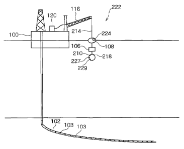
FIG. 1 is a simplified view of an offshore rig positioned over a borehole
containing a
plurality of receivers. The rig is shown supporting a conventional seismic
survey apparatus.
FIG. 2 is a simplified view of an offshore rig positioned over a borehole
containing a
plurality of receivers. The rig is shown supporting a seismic survey apparatus
with a source
control system according to one aspect of the present invention.
FIG. 3 is a schematic diagram illustrating a source control system according
to one
aspect of the present invention.
FIG. 4 is a schematic illustration of a source control method according to one
aspect of
the present invention.
FIG. 5 is a schematic illustration of a source control method according to
another aspect
of the present invention.
FIG. 6 is a single, near field air gun signature with pressure and frequency
shown as a
function of time.
FIG. 7A is an illustration of air gun peak tuning according to one aspect of
the present
invention.
FIG. 7B is an illustration of air gun bubble oscillation tuning according to
another aspect
of the present invention.
Throughout the drawings, identical reference numbers indicate similar, but not
necessarily identical elements. While the invention is susceptible to various
modifications and
alternative forms, specific embodiments have been shown by way of example in
the drawings
and will be described in detail herein. However, it should be understood that
the invention is
not intended to be limited to the particular forms disclosed. Rather, the
invention is to cover all
modifications, equivalents and alternatives falling within the scope of the
invention as defined
by the appended claims.
DETAILED DESCRIPTION OF THE PREFERRED EMBODIMENTS
Illustrative embodiments and aspects of the invention are described below. In
the
interest of clarity, not all features of an actual implementation. are
described in this specification.
5
CA 02526072 2005-11-16
WO 2004/102223 PCT/IB2004/001504
It will of course be appreciated that in the development of any such actual
embodiment,
numerous implementation-specific decisions must be made to achieve the
developers' specific
goals, such as compliance with system-related and business-related
constraints, that will vary
from one implementation to another. Moreover, it will be appreciated that such
a development
effort might be complex and time-consuming, but would nevertheless be a
routine undertaking
for those of ordinary skill in the art having the benefit of this disclosure.
The present invention contemplates methods and apparatus for use in vertical
seismic
profile (VSP) and other borehole seismic surveys. The principles described
herein facilitate
generation of more accurate seismic source information than previously
possible, adding
precision to seismic data to enable sophisticated seismic data processing. The
methods and
apparatus of the present invention are preferably implemented to correct or
compensate for
variations in marine conditions, and/or provide for synchronization between
source firing,
downhole seismic receiver recording, and (optionally) surface seismic receiver
recording.
However, while the methods and apparatus are shown in marine implementations,
they may also
be used for land applications.
The methods and apparatus facilitate better seismic data analysis by more
accurately
providing source signatures. More accurate source signatures are a result of a
source control
system described below which may, for example, vary seismic source firing to
coincide with a
predetermined wave height for every shot in a marine application. Sea swells
and tidal
variations can introduce noise to seismic data and render it difficult or
impossible to estimate
the source signature. For example, sea swells of 3m can lead to a 2ms time
displacement due to
the potential differences in vertical displacement of a buoyed source. Larger
swells can have an
even more significant effect. For example, when shots are stacked during a rig-
side VSP or an
offset VSP, the change in travel time for each shot results in smearing of the
seismic signals
received during stacking and a loss of high frequencies. In fact, because of
the noise that can be
created by rough seas, marine surveys have previously been limited to
conditions when sea
swells are something less than approximately 3 to 4 in.
Turning now to the figures, and in particular to FIG. 1, a simplified view of
an offshore
rig (100) positioned over a subsea borehole (102) is shown. The borehole (102)
contains a
plurality of spaced receivers (103) to facilitate, for example, a vertical
seismic profile (VSP)
acquisition. The rig (100) is shown supporting a conventional seismic survey
apparatus
designated generally as (104). The survey apparatus (104) includes an air-gun
or guns (106)
suspended below the surface by a float (108). An analog hydrophone (110) is
suspended below
6
CA 02526072 2005-11-16
WO 2004/102223 PCT/IB2004/001504
the air-gun (106). As discussed above, the hydrophone (110) can provide
partial information
for correcting time break errors (errors attributable to time differences for
swells, irregular
source firings, etc.) but not enough information for shot deconvolution. The
hydrophone (110)
of the typical survey apparatus (104) is not automatically calibrated and
therefore dependent on
the user, which often changes.
One or more analog lines (112) form part of an umbilical (114) that may also
include an
air line. The analog lines (112) traverse a handling system, such as a crane
(116). The analog
lines (112) provide an analog communications/control link between the guns
(106), the
hydrophone (110), a gun controller (118), and a computer processor (120). The
gun controller
(118) is arranged on the rig (100), far removed from the guns (106). Currently
the lack of a
display at the gun controller (118) or the computer processor (120) of the
hydrophone readings
or the air gun depth or pressure at the gun creates operational shortcomings.
In addition,
disconnection of the analog lines (112) while the air gun is powered can
result in inadvertent
firing of the air-gun (106) that may pose a safety hazard.
Therefore, according to the conventional arrangement of FIG. 1, seismic data
quality is
compromised. The position (referring primarily to depth) of the guns (106) is
dependant on rig
movement, waves, crane operation, and/or other factors. Prior to the teachings
described herein,
there has been no compensation or correction for changes in depth, no
compensation for
changes in air pressure, very limited ability to time the firing of the guns
(106), and therefore
the source signature of the guns (106) and the wave amplitude are far from
optimal.
However, a source control system according to one aspect of the invention
illustrated in
FIG. 2 facilitates much more accurate seismic data. According to the
arrangement of the FIG. 2,
there is also an offshore rig (100) positioned over a subsea borehole (102)
containing a plurality
of receivers (103). The rig (100) is shown supporting the source control
system and designated
generally as (222). The rig (100) may be replaced, according to some
embodiments, with a
movable vessel. The source control system (222) includes a seismic source, a
handling system,
an umbilical (214), and an in-sea source controller (218) for controlling the
firing of the seismic
source. The source control system (222) and the borehole receivers (103) may
be integrated to
provide a borehole survey system.
According to the embodiment of FIG. 2 the seismic source is the air-gun (106),
which
may be a single gun, an array of guns, or any other arrangement. The handling
system includes
a crane (116) and associated apparatus to facilitate the deployment and
retrieval of the source
control system (222) and air gun (106). The umbilical (214) includes an air
supply, which is
7
CA 02526072 2005-11-16
WO 2004/102223 PCT/IB2004/001504
operatively connected to a compressor. The compressor is preferably located on
the rig (100).
However, unlike the typical survey apparatus with long analog communication
lines, the
umbilical (214) of the source control system (222) according to FIG. 2
includes only digital
communication lines between the in-sea source controller (218) and the
processor (120) on the
rig (100). The use of digital lines eliminates any crosstalk, signal leakage,
and the potential for
an inadvertent gun firing upon removal of the communication links. As
mentioned above, the
air gun (106) is controlled by the in-sea controller (218) and generates
seismic waves that are
received by the borehole receivers (103) to generate, for example, a VSP
survey.
The source control system (222) may also include an attached float (108) to
buoy the air
gun (106), the in-sea controller (218), and any other in-sea apparatus. The
float (108) may
advantageously include a navigational system or motion sensor, such as a
Global Positioning
System (224) (GPS). GPS systems are readily available from a variety of
sources. The GPS
system (224), among other things, facilitates detection of changes in vertical
height (due, for
example, to waves or changes in tide). As mentioned above, firing the air guns
(106) at
different wave heights can adversely affect the determination of the source
signature of the air
gun (106) and/or other data collected by the borehole receivers (103).
Accordingly, the GPS
system (224) feeds position information to the processor (120) and/or the in-
sea source
controller (218) so that the air-gun (106) may be fired only at certain
heights. The firing of the
air gun (106) at certain heights may be controlled by a switch or other
mechanism associated
with the GPS system (224) or the in-sea controller (218), such that the air-
gun is automatically
fired at a certain, predetermined wave height. Conventional marine surveys
fire air-guns at
regular time intervals, regardless of height. The addition of a motion sensor
according to
principles described herein increases the accuracy of the source signature
determination,
discussed in more detail below.
In addition to providing position information, the GPS system (224) may also
receive
and broadcast a time standard to the in-sea controller (218), the processor
(120), and/or any
navigation subsystems that may be used with source control system (222). This
time standard
may, for example, be Universal Time Coordinated (UTC). The UTC time standard
may be
supplied to various survey subsystems to synchronize the firing of the air
guns (106) with the
recording of data by the borehole receivers (103). According to some
embodiments, there may
also be surface receivers, the recording of which may also be synchronized
with air gun (106)
firing using the time standard provided by the GPS system (224).
8
CA 02526072 2005-11-16
WO 2004/102223 PCT/IB2004/001504
Further, according to some embodiments, the in-sea source controller (218) may
include
one or more in-sea sensors providing signals to enable, among other things,
source signature
estimation. Preferably, the in-sea sensors are located at the in-sea source
controller (218) and
maintain a fixed geometry relative to the air gun (106) or other seismic
source. The one or more
in-sea sensors may include, but are not limited to: a calibrated digital
hydrophone (210), a depth
sensor (227), and an air pressure sensor (229). The one or more in-sea sensors
may also include
short analog communication lines to the in-sea source controller (218), where
the signals may
be digitized at the source for relay to the processor (120). Therefore,
according to the
embodiment of FIG. 2, if the source control system (222) includes analog
lines, those lines are
relatively short, instead of the very long analog lines found in previous
survey systems that
extend all the way from the seismic source to the rig. The hydrophone (210)
according to the
present invention provides improved fidelity of a near field signal because it
is calibrated in-sea
and digitized at the seismic source. In addition, the air pressure sensor
(229) monitors air
pressure supply at the air-gun source and reports firing pressure variations
which can be taken
into account when determining the source signature. Accordingly, the seismic
source signature
may be more accurately estimated by accounting for timing variations,
hydrodynamic variations,
pressure supply variations, etc., using the calibrated digital hydrophone
(210) signal and air
pressure readings at the seismic source.
Estimation of an accurate source signal is highly important to VSP processing.
The
source signal enables separation of the upgoing and downgoing wavefields.
Inconsistent source
signatures result in residuals in collected data by the multi-channel velocity
filters used to
separate wavefields. These residuals are effectively "noise" and can cause
significant distortion
to the processed results. With an ever-increasing focus on true amplitude and
time-lapse
borehole seismic measurements, source signature consistency is very important
to VSP surveys.
Good source signature estimation using the methods and apparatus taught herein
increase the
consistency of the source signature.
Calibrating the source signatures has in the past been accomplished by visual
quality
checks. These visual checks include, for example, looking for air guns that
did not fire and
ensuring the frequency response covers both low and high ends. Such checks are
somewhat
subjective, however, and even more so if the air-gun (106) reference far field
source signature is
unknown. According to the present embodiment having the in-sea source
controller (218),
however, the air-gun (106) source reference far field signatures are on file
at the well site, so the
source control system (222) can be programmed to automatically check the
measured source
9
CA 02526072 2005-11-16
WO 2004/102223 PCT/IB2004/001504
signature against the reference source signature. By performing an automatic
check, there is an
assurance that for each well site setup the air-gun (106) source signature
meets its performance
acceptance criteria. Calibrated and consistent source signatures are important
for evaluating the
subsurface changes in time-lapse surveys. With a calibrated source signature,
variations in
seismic reflections will be representative of subsurface changes, instead of
changes in the
source signature.
Seismic sources signatures for VSP must be surface referenced, and if there is
a change
in datum level (e.g. as the air-gun (106) rises and falls in a rough sea),
there will be small 1 or 2
ms time shifts. However, the changes in datum level may be eliminated or
compensated for by
using the GPS system (224) or other motion sensing equipment. Further,
heretofore tidal
corrections have not been made for borehole seismic measurements. While
failing to make tidal
corrections may be acceptable for deep-water surveys, depending on the time of
day and the
strength of the tide, there maybe a significant affect on transit times in
coastal areas. Therefore,
according to some embodiments the source control system (222) includes a depth
sensor (227)
to monitor the depth of the air gun (106) below the water surface. The depth
sensor (227) may
be, for example, a commercially available bathymetry sensor. Variations in
tide may then also
be accounted for according to principles described herein. In addition, the
air-gun (106) may be
automatically disabled if the depth sensor (227) reports a depth less than a
predetermined level.
The attributes reported by the in-sea sensors may be automatically displayed
at the processor
(120) for a user to see.
The configuration of the air-gun (106) may be a cluster arrangement, such as a
three-gun
cluster. However, any other air-gun arrangement may also be used. For example,
some
embodiments may include air-gun clusters of up to eight guns or more. Prior
methods are
restricted to simultaneous firing of air guns. The digital in-sea controller
(218) in the present
invention provides the capability to stagger the firing of an array of air
guns (106), which has
previously been unavailable using rig-based analog controllers that lack the
tuning flexibility to
fire sequentially.
Referring next to FIG. 3, a schematic illustration of one possible source
control system
(400) configuration according to aspects of the present invention is shown. As
shown in FIG. 3,
the processor (120) may be a laptop computer running a digital source control
program. The
processor (120) may control and/or monitor the in-sea controller and sensors
(218) described
above with reference to FIG. 2, which may also include the GPS system (224,
FIG. 2). The
communication interface between the processor (120) and the in-sea controller
(218) and
CA 02526072 2005-11-16
WO 2004/102223 PCT/IB2004/001504
sensors (227, 229) is preferably a digital link (430). This digital link (430)
may be used for pre-
testing the system in preparation for data acquisition. The processor (120)
may also link with an
acquisition and imaging system (432), for example Schlumberger's MAXISTM
(Multitask
Acquisition and Imaging System) system via another digital interface (434).
The acquisition
and imaging system (432) may include a GPS digital data interface (436) as
shown.
Alternatively, the processor (120) may contain a GPS digital data interface
(436). The
processor (120) and acquisition and imaging system (432) are located on the
rig according to the
illustration of FIG. 3, however, as the name suggests, the in-sea controller
and sensors (218) are
located in the water adjacent the air-gun (106) or other seismic source. The
in-sea controller
and sensors (218) may also have a digital interface (438) with the acquisition
and imaging
system (432). This direct digital interface (438) may provide the primary
interface with the
acquisition and imaging system (432) during data acquisition. The only analog
interface (440)
of the source control system (400) extends the short distance between the in-
sea controller and
sensors (218) and the air-gun source (106).
Turning next to FIGs. 4-5 schematic illustrations representing methods of
using the
source control system (222) and/or improving a VSP survey are shown. It will
be understood,
however, that the methods shown and described are not limited to the
particular sequences
shown, nor must all the steps described be performed. The steps described may
be
accomplished in any of a number of sequences. According to one method, a
seismic source
such as an air-gun cluster (FIG. 2) is automatically tuned, for example, by
the in-sea source
controller (218). The in-sea source controller (218) may keep individual air-
guns (106, FIGs. 2-
3) firing in synchronization with one another by aligning first pressure peaks
detected by the
hydrophone (210, FIG. 2) located adjacent the air-guns (106, FIGs. 2-3).
However, an air-gun's
first pressure peak is dominant at high frequencies, which may not represent
what is actually
measured in deep attenuative formations. A bubble peak, on the other hand,
occurs after the
first pressure peak, is much lower in frequency content, and propagates down
into deep
attenuative formations. FIG. 6 illustrates a single, near-field gun signature,
with no ghost. As
shown, low frequency energy is centered upon a first bubble oscillation.
Therefore, according to some embodiments, the in-sea source controller (218)
may tune
or synchronize individual air-guns (218) with one another by aligning the high
frequency
pressure peaks, by aligning low frequency bubble oscillations, or by other
methods. FIGs. 7A
and 7B illustrate aligning high frequency pressure peaks, and low frequency
bubble oscillations,
respectively, of guns of different sizes. As shown, the bubble wavelets of
FIG. 7B have a better
11
CA 02526072 2005-11-16
WO 2004/102223 PCT/IB2004/001504
peak-to-peak amplitude, are more compact, and are generally easier to identify
and pick.
Accordingly, tuning on the bubble oscillations is more efficient if low-
frequency energy is
required.
The methods of using the source control system (222, FIG. 2) or improving a
VSP
survey further include measuring the air-gun (106, FIG. 2) pressure directly
at the source. The
measurement of air-gun (106, FIG. 2) pressure may be facilitated, for example,
by the pressure
sensor (229, FIG. 2) of the in-sea sensor arrangement described above with
reference to FIG. 2.
The depth of the air-gun (106, FIG. 2) is also measured directly by the
source. The
measurement of air-gun (106, FIG. 2) depth may be facilitated, for example, by
a bathymetry
sensor or other depth sensor (227, FIG. 2) as described above. The methods
also include
integrating a firing of the air-gun (106, FIG. 2) with a navigation system to
facilitate air-gun
(106, FIG. 2) firing at either a precise time or a precise predetermined
position, or both. The
advantages of firing the air-gun (106, FIG. 2) or other seismic source only at
precise-positions
are described above.
The navigation system for facilitating air-gun (106, FIG. 2) firing at certain
vertical
positions may be, for example, the GPS system (224, FIG. 2) discussed with
reference to FIG. 2,
which receives and broadcasts precise position data. The GPS system (224, FIG.
2) may also
receive and broadcast a time standard such as UTC. Accordingly, the air-gun
(106, FIG. 2) may
be controlled according to time and position information received from the GPS
system (224,
FIG. 2), and fired only at a certain, predetermined wave height to reduce or
eliminate time-shift
errors. Further, according to some methods, the firing of the air-gun (106,
FIG. 2) may be
synchronized with downhole seismic receiver recording according to UTC time or
another time
standard. Indexing the data according to a time standard facilitates pre-
sorting of the data for
processing. Indexing the source performance and the receivers' recording
according to a time
standard also permits these data to be combined in the same dataset or file,
thereby facilitating
review, reporting, or data processing. Statistical quality control (QC)
analysis of surface source
performance and the borehole receiver (103, FIG. 2) performance may then be
combined. In
some cases, firing of the air-gun (106, FIG. 2) may also be synchronized with
surface seismic
receiver recording. Accordingly, statistical quality control (QC) analysis
could then be
performed for the synchronized data set, including surface source signal,
signals received by
surface receivers, and signals received by borehole receivers.
According to some methods, a correction is made for source signature
variations.
Source signature variations may result, for example, from firing pressure air
changes,
12
CA 02526072 2005-11-16
WO 2004/102223 PCT/IB2004/001504
temperature changes, rough seas, or tidal variations. The correction may
include calibrating a
near field sensor signal received by the hydrophone (210, FIG. 2) located at
the air-gun (106,
FIG. 2) or other seismic source, according to the fixed geometry of the air-
gun (106, FIG. 2) to
the hydrophone (210, FIG. 2). The hydrophone (210, FIG. 2) may be part of the
in-sea sensor
package discussed above. The correction may further include reconstructing the
far field
signature of the air-gun (106, FIG. 2) or other source from measured near
field signature, and
maintaining true amplitude for surface seismic calibrations, AVO (amplitude
variations with
offset) surveys, and time-lapse surveys. In addition, corrections of the
source signature may be
made by comparing measured source signatures to a reference source signature,
where the
reference source signature is based on a seismic source reference far field
signature on file at the
well site.
The preceding description has been presented only to illustrate and describe
the
invention and some examples of its implementation. It is not intended to be
exhaustive or to
limit the invention to any precise form disclosed. Many modifications and
variations are
possible in light of the above teaching.
The preferred aspects were chosen and described in order to best explain the
principles
of the invention and its practical application. The preceding description is
intended to enable
others skilled in the art to best utilize the invention in various embodiments
and aspects and
with various modifications as are suited to the particular use contemplated.
It is intended that
the scope of the invention be defined by the following claims.
13