Note: Descriptions are shown in the official language in which they were submitted.
CA 02703384 2013-09-17
30406-15
SYSTEM AND METHOD FOR DETERMINING INTERSECTION RIGHT-OF-WAY
FOR VEHICLES
FIELD OF THE INVENTION
[0001] The present invention relates generally to intelligent vehicle
systems and more
specifically to determining which vehicle(s) have right of way at an
intersection and
communicating that information to the vehicles.
BACKGROUND OF THE INVENTION
[0002] There is increasing efforts for integrating communication and
computing
technologies into motor vehicles to improve the safety and efficiency of
roadways. For
example, the US government has an ongoing Intelligent Transportation Systems
initiative (US
Department of Transportation, Intelligent Transportation Systems).
[0003] The ability to determine the location of moving vehicles via a
Global
Positioning System (GPS) or other location determination means for the purpose
of collision
avoidance is known, for example, see, US Patent 6,405,132, which describes an
accident
avoidance system. Additionally, US Patent 6,281,808 describes an intelligent
control of
traffic signals.
[0004] However, these systems and methods do not address an automated
determination and dissemination of right of way information when multiple
vehicles approach
an (uncontrolled) intersection.
SUMMARY
[0004a] According to an aspect of the present invention, there is
provided a method for
determining right of way for a plurality of mobile units at an intersection,
the method
comprising: collecting position and movement information about the plurality
of mobile units
approaching the intersection; storing a plurality of rules about right of way
at the intersection;
accessing information about geometry of the intersection; calculating which
one or more of
the plurality of the mobile units have right of way to enter the intersection,
in response to the
- 1 -
CA 02703384 2013-09-17
=
30406-15
position and movement information, the stored rules and the information about
geometry of
the intersection; detecting whether a traffic signal at the intersection is
functional; and
wirelessly transmitting right of way indication signals to one or more of the
plurality of the
mobile units when the traffic signal is detected to be not functioning.
10004b1 According to another aspect of the present invention, there is
provided a
system for determining right of way for a plurality of mobile units at an
intersection
comprising: a stationary unit adapted to collect position and movement
information about the
plurality of mobile units approaching the intersection; storage media adapted
to store
information about geometry of the intersection and a plurality of rules about
right of way at
the intersection; a processing unit adapted to calculate which one or more of
the plurality of
the mobile units have right of way to enter the intersection, based on the
stored information
and the position and movement information; and a communication unit adapted to
wirelessly
transmit right of way indication signals to one or more of the plurality of
the mobile units;
wherein the stationary unit is adapted to detect whether a traffic signal at
the intersection is
functional; and wherein the processing unit is configured to start calculating
and transmitting
when the traffic signal is detected to be not functioning.
[0004c] According to another aspect of the present invention, there is
provided A
system for determining right of way for a plurality of mobile units at an
intersection
comprising:
means for collecting position and movement information about the plurality of
mobile units approaching the intersection;
means for storing information about geometry of the intersection and a
plurality of rules about right of way at the intersection;
means for calculating which one or more of the plurality of the mobile units
have right of way to enter the intersection, based on the stored information
and the position
and movement information; and
- la-
CA 02703384 2013-09-17
30406-15
means for wirelessly transmitting right of way indication signals to one or
more of the plurality of the mobile units;
wherein the means for collecting are adapted to detect whether a traffic
signal
at the intersection is functional; and
wherein the means for calculating and transmitting are configured to start
calculating and transmitting when the traffic signal is detected to be not
functioning.
100051 Some embodiments provide a method and system for determining
right of way
for a plurality of mobile units at an intersection. The method and system
include collecting
position and movement information about the plurality of mobile units
approaching the
intersection; storing a plurality of rules about right of way at the
intersection; accessing
information about geometric and/or map representation of the intersection;
calculating which
one or more of the plurality of the mobile units have right of way to enter
the intersection,
responsive to the position and movement information, the stored rules and the
geometric
and/or map representation information; and wirelessly transmitting right of
way indication
signals to one or more of the plurality of the mobile units.
BRIEF DESCRIPTION OF THE DRAWINGS
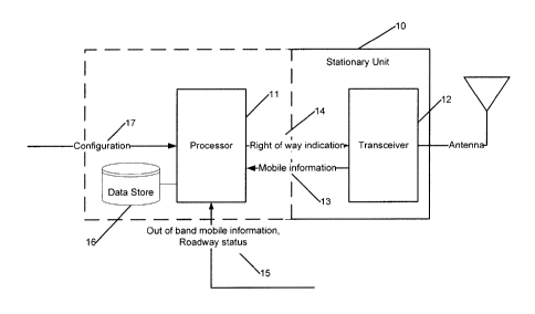
[0006] FIG. 1 shows an exemplary configuration of a stationary
(roadside) unit,
according to some embodiments of the present invention.
[00071 FIG. 2 illustrates a system for determining right of way at a
traffic intersection,
according to some embodiments of the present invention.
[0008] FIG. 3 illustrates an exemplary processing flow associated
with determining
the right of way, according to some embodiments of the present invention.
- lb -
CA 02703384 2010-04-21
WO 2009/058784
PCT/US2008/081465
1
DETAILED DESCRIPTION
[0009] In some embodiment, the present invention includes a stationary
communications
and processing unit located near a traffic intersection, the intersection
being either
uncontrolled or having a traffic signal that is not operational. The
stationary unit has access
to a map and/or geometric representation (for example, in a geographical
information system
(GIS) format) of the intersection, and to right of way and safety rules
related to the
intersection. The stationary unit collects real-time position and movement
information about
one or more vehicles approaching the intersection as well as the status of the
traffic signal, if
one exists. Using this information, and taking into account safety rules and
the map response
information, the stationary unit determines which vehicle(s) have right of way
at the
intersection and then communicates that information to the vehicles.
[0010] FIG. 1 shows an exemplary configuration of a roadside unit,
according to some
embodiments of the present invention. A stationary unit, for example, roadside
unit 10 may
be positioned near an intersection and may include wireless communications
means, such as a
transceiver 12, allowing connectivity with the vehicles approaching an
intersection. A
processing unit 11 calculates and generates right of way indications
information14. Although
shown local to the roadside unit, the processing unit may be remote to the
roadside unit. The
roadside unit 10 also includes knowledge of the intersection and surrounding
geometry, for
example, via stored detailed map information 16 stored in a database (storage
medium). This
information knowledge of intersection may be stored remotely and communicated
to the
roadside unit on demand basis.
[0011] FIG. 2 illustrates a system (environment) for determining right
of way at a traffic
intersection, according to some embodiments of the present invention. Vehicles
21 include
wireless communications capability, allowing connectivity with one or more
roadside units.
Vehicles 21 may also include operator interface, with the ability to indicate
right of way (or
lack thereof), for example in a way of display, voice activated indication,
and/or sensors,
servos and actuators for automatically controlling the movements of the
vehicles, for
example, in the case of un-manned vehicles. Vehicles 21 may also include
position
determination capability, where accurate and timely mobile information 13 is
determined and
communicated to the roadside unit, allowing the roadside unit to track and
predict vehicle
trajectories. The positioning capability used to determine the positions of
the vehicles 21,
may be onboard the vehicles, for example, satellite based, like GPS,
differential GPS, a
combination of GPS and future satellite systems, or may be using embedded
sensors 23 in the
roadside unit, and/or around the intersection, or may use combinations of such
positioning
methods to yield accurate, lane and sub-lane level positioning. Existing
navigation units in
the vehicle may be used for some of these functions.
-2-
CA 02703384 2010-04-21
WO 2009/058784
PCT/US2008/081465
1 [0012] Additionally, the system may include an out of band (e.g.,
wireline)
communications means 24, that allows the roadside unit 10 to receive such
information as
operational status from a local traffic signal 22, traffic status from the
local sensors 23,
database and configuration updates 17 from a remote source, and the knowledge
of the
intersection if such information is stored remote to the roadside unit.
[0013] Using the knowledge of the intersection and surrounding locale,
the processor unit
11 evaluates vehicle (mobile unit) movement in the context of the intersection
and local
environment. Vehicle movement information includes at least vehicle location.
From a
series of location updates, vehicle direction, speed, and acceleration may be
either calculated
onboard the vehicle and reported to the roadside unit, or calculated in the
processor
associated with the roadside unit. Additional information that pertains to
vehicle movement
may be included. This additional information may include real-time information
such as
vehicle braking or turning status. The additional information may also include
vehicle
parameters that affect the vehicle's movement or priority, such as weight and
size, or vehicle
status (for example, emergency vehicle). Local information may include the
route of roads
entering the intersection, prevailing speed limits on those routes, location
of turn-only lanes,
size and orientation of the intersection itself, etc. In some embodiments, the
local
information (or a portion thereof) is received from a central source. The
local information
may be entered in the roadside unit directly or via messages received over a
network
connection. The evaluation in the processor includes such calculations as a
prediction on
when the vehicle will reach the intersection, the path it will take, and when
it will exit the
intersection.
[0014] Real time information may include the location/heading/speed of
approaching
traffic, vehicle acceleration, and vehicle capabilities, such as the ability
to accept and process
right of way messages. This vehicular information may be received via reports
or messages
from the vehicles themselves, as well as from sensors (for example, cameras,
radar, magnetic
strips embedded in the roadway, etc.) positioned in proximity of the
intersection. Real time
information may also include prevailing conditions that affect traffic, such
as weather, road
condition and visibility, lane closures, constructions, etc.). This
information may be received
by the stationary unit from a central source, and/or from a local source
(e.g., a road work
crew, and/or various local sensors). In some embodiments, the prevailing
conditions that
affect traffic and the road are given different importance weights. For
example, if a road is
closed, no matter what, no vehicle would be allowed to go through, if the road
is wet, the
importance of the speed of the vehicles is increased, or if the visibility is
weak, the
importance of distance to the intersection is increased.
[0015] The wireless communication means (for example, 12 in FIG. 1)
may be any
communications that allows low-latency information transfer between vehicles
and the
stationary unit. One technology particularly suited to this purpose is
alternately known as
-3-
CA 02703384 2010-04-21
WO 2009/058784
PCT/US2008/081465
1 wireless access in vehicular environments (WAVE) or dedicated short range
communications
(DSRC). Vehicles could automatically generate periodic updates of their
positions and status
and/or the roadside unit can poll the vehicles for this information.
100161 Traffic rules are construed and programmed based on the
prevailing laws in effect
at the locale, applied to the specific topology of the intersection. Some
simplified examples
of such rules are shown here in the form of right of way priority lists for
two exemplary
scenarios. A vehicle whose trajectory will not cause a collision or near-
collision with any
other vehicle is granted right of way. Otherwise, the vehicle(s) meeting the
criterion highest
on the list is granted right of way over all other approaching vehicles.
1 - Minor road crossing a major road:
i) Emergency vehicle
ii) Through traffic on major road.
iii) Right turning vehicle from major road.
iv) Left turning vehicle from major road.
v) Through traffic on minor road.
vi) Right turning vehicle from minor road.
vii)Left turning vehicle from minor road.
2 - Crossing of two minor roads:
i) Emergency vehicle
ii) First vehicle to the intersection.
iii) In the case of simultaneous arrivals:
(1) If vehicles arrive at adjacent intersection entrances, the rightmost
vehicle.
(2) If vehicle arrive from opposite intersection entrances, the through or
right-
turning vehicle(s).
[0017] The vehicles that receive the right of way messages from the
stationary unit may
act on the information in different ways depending on system design and
vehicle capabilities.
An on-board light or display (e.g., red/yellow/green) may be used to indicate
right of way to
the driver. Alternately, or in conjunction, different audible tones could
express that
information. Language-based information could also be provided, audibly,
and/or visually.
If the vehicle is equipped with an automatic control feature, the right of way
information
could be used by the vehicle controller to invoke braking, steering, and/or
accelerating/decelerating controls to prevent the vehicle from entering the
intersection or
parts thereof if right of way has not been granted.
[0018] FIG. 3 illustrates an exemplary process flow associated with
determining the right
of way, according to some embodiments of the present invention. In block 31,
the process
collects infrastructure status information, such as whether the local traffic
signal is functional.
From this information, in block 32, the process determines whether a right of
way
determination process is needed at the current time, for example, if the
signal is not
-4-
CA 02703384 2010-04-21
--------------------
WO 2009/058784
PCT/US2008/081465
1 functional. If a determination process is needed, the process collects
mobile unit status, in
block 33, for example from wireless signals and/or roadside sensors. If no
mobile units
(vehicles) are detected (block 34), the process continues monitoring for the
presence of any
newly-arrived vehicles. If mobile units are detected, the process invokes the
right of way
rules to determine which mobile unit or units has right of way, in block 35.
The process then
reports the result to all present mobile units, in block 36. Upon receiving
the right of way
determination results, the vehicles act according to the results, as explained
above.
[0019] An exemplary scenario follows. Assume that multiple intelligent
vehicles
approach an intersection and the traffic signal at the intersection is
temporarily disabled due
to a failure. The vehicles at intervals automatically report their positions,
directions, and
speeds to a stationary unit located at or near the intersection. Using its
knowledge of the
intersection geometry, programmed traffic rules, vehicles' trajectories, and
local information
(such as weather or road condition) the roadside unit sends right of way
messages or
commands to each of the vehicles, which are in turn conveyed to the drivers or
to the control
systems of each vehicle. For example, north-south bound vehicles are sent a
STOP message,
conveyed to drivers by a red dashboard light and/or an audible command. East-
west bound
vehicles are sent a PROCEED WITH CAUTION message, displayed perhaps as a
green/yellow light and/or audible indication. Once the initial east-west bound
vehicles clear
the intersection, subsequent east-west bound vehicles receive STOP messages,
and north-
south bound vehicles receive PROCEED WITH CAUTION messages.
[0020] Different countries or legal jurisdictions may have different
rules for right of way.
Different rules may include granting priority to the first vehicle to arrive,
the vehicle on the
more major roadway, or the vehicle arriving from the other vehicle's right.
Thus the right of
way determination algorithm is programmed to reflect local laws.
[0021] In some embodiments, the roadside unit recognizes (e.g., via the
above-mentioned
sensors) an approaching vehicle that does not have the ability to process the
right of way
messages, that is, a non-intelligent vehicle. In this case, the roadside
unit's right of way
determination may hold back the intelligent vehicles to allow the non-
intelligent vehicle to
pass safely. In some embodiments, the roadside unit recognizes emergency
vehicles and
grants them right of way over non-emergency vehicles.
[0022] In some embodiments, the roadside unit considers turning
intentions of a vehicle
determined through any of a number of means, such as location of the vehicle
in a turn lane,
direction vector of the vehicle or activation of a turn signal within the
vehicle. Additionally,
the intelligent vehicle may have knowledge of its route or end destination and
be able to
provide an explicit report to the stationary unit, indicating its immediate
intentions at the
intersection (e.g., proceed straight, turn left, etc.), as it approaches the
intersection.
[0023] In some embodiments, the roadside unit monitors the status of
the traffic signal
controlling access to the intersection, and performs right of way
determination when
-5-
CA 02703384 2013-09-17
30406-15
1 detecting a disruption of the signal's functionality, an emergency, or
any other appropriate
condition. In some embodiments, the roadside unit performs right of way
determination in
the presence of a functional signal, to provide guidance in situations where
right of way is not
unambiguously indicated by the signal. Such a case is where a left-turning
vehicle has a
green light, but must yield to oncoming traffic.
100241 In some embodiments, to prevent the possibility of directing a
vehicle into a
dangerous situation, the system provides negative messages to vehicles not
found to have
right of way in addition to providing positive messages granting right of way.
[0025] Note that for simplicity reasons, the disclosure assumes a
typical intersection with
two crossing perpendicular roadways. However, the present invention can be
applied equally
to other situations where intersecting traffic patterns cause a potential for
collisions.
Examples of alternate types of intersections include, but are not limited to,
merges, traffic
circles, driveways entering a roadway, and intersections with less or more
than four
entrances.
[0026] It can also be seen, that though this invention has been described
in the context of
a public roadway, alternate embodiments also represent the invention. For
example, the
invention can be applied to maritime navigation systems, airport ground
traffic, and industrial
machinery. In these applications different rules stored in the system would
govern the right
of way determination and different factors, for example the weather in the
airport case and
the wind or water conditions in the maritime navigation case may be given
different weights.
10027] In summary, while certain exemplary embodiments have been
described above in
detail and shown in the accompanying drawings, it is to be understood that
such
embodiments are merely illustrative of and not restrictive of the broad
invention. In
particular, it should be recognized that the teachings of the invention apply
to a wide variety
of systems and processes. It will thus be recognized that various
modifications may be made
to the illustrated and other embodiments of the invention described above,
without departing
from the broad inventive scope thereof. In view of the above it will be
understood that the
invention is not limited to the particular embodiments or arrangements
disclosed, but is rather
intended to cover any changes, adaptations or modifications which are within
the scope
10 of the invention as described herein.
=
=
-6-