Note: Descriptions are shown in the official language in which they were submitted.
CA 02876953 2015-01-08
MAP ANALYTICS FOR INTERACTIVE WEB-BASED MAPS
TECHNICAL FIELD
[0001] The present disclosure relates to mapping, and more particularly to
analytics for
interactive web-based maps.
BACKGROUND
[0002] Web based mapping services allow interactive maps to be displayed in a
Web
browser. A Web browser (referred to herein simply as a "browser") is a
software program
that can retrieve and present information on the World Wide Web in the form of
web pages
and typically can also run specialized programs written in a suitable
scripting language such
as JavaScript. Such programs are referred to herein as "browser-executable
software
programs". Interactive maps can be embedded in a web page. For example, Google
Inc.,
having an address at 1600 Amphitheatre Parkway, Mountain View, CA 94043
(U.S.A.)
provides a web-based mapping service under the name "Google Maps", and the
Google Maps
API (Application Programming Interface) allows a Google Maps map to be
embedded into an
external web site. Information on embedding a Google Maps map into an external
website is
provided at https://developers.google.com/maps/tutorials/fundamentals/adding-a-
google-map,
the teachings of which are hereby incorporated by reference. A business may
use this
functionality to embed in its web page an interactive map that shows the
location of the
business.
[0003] In many web map applications, a tile-based architecture is used. A map
server will
store a plurality of maps, with each map made up of a set of contiguous square
sections
referred to as "tiles", typically representing 256 pixels by 256 pixels
although other sizes may
be used. Each tile may take the form of a static image, or may take the form
of (for example)
raster image data or vector image data. Each map has a specified zoom level,
with higher
zoom levels showing more detail and hence needing more tiles to cover a given
region.
Conventionally, zoom levels are incremented by powers of four. Thus, at zoom
level zero
(z0), a single tile (i.e. 40 = 1) represents the entire earth, at zoom level
one (z 1), four tiles (i.e.
41 = 4) represent the entire earth, at zoom level two (z2), sixteen tiles
(i.e. 42 = 16) represent
- 1 -
CA 02876953 2015-01-08
the entire earth, and so on. Tile based maps use a z/x/y coordinate system in
which "z"
specifies the zoom level and the "x" and "y" coordinates specify the position
of the tile within
a Cartesian grid for that zoom level.
[0004] While it is possible to manually select and position the necessary
tiles to produce a
desired map view, in practice a library, referred to as a map client, is used
to automate this
process. The map client, often written in JavaScript so that it can execute
within the browser,
can determine which tiles are needed to present a map of a particular region
at a particular
zoom level. Thus, a developer can provide the map client with the coordinates
(latitude and
longitude) on which to center the map and with the desired zoom level, and the
map client can
then determine the appropriate tiles.
[0005] While a tile-based web map may be displayed statically, it is common to
enable a user
to interact with the web map by panning (moving the map window relative to the
presently
displayed map) and zooming. In response to such user interaction, the map
client may request
the tiles needed to display the relevant portions of the map at the
appropriate zoom level.
[0006] Some map clients permit additional features to be added to the
displayed maps. For
example, the Google Maps API allows site-specific information to be overlaid
on the
displayed map. One common example of an additional feature is to add clickable
markers at
particular locations on the displayed map to enable further interactivity. In
one such
implementation, clicking on a marker representing the location of a business
may cause
information about that business to be displayed in the browser.
[0007] While the ability to present interactive web maps has many advantages,
the selected
presentation may not be optimal. For example, a business website may include a
web map
where the initial zoom level is too great for a user to locate the business in
relation to nearby
landmarks within the city or town, or is insufficient for a user to be able to
discern the identity
of the street where the business is located. Similarly the web map may not be
centered
appropriately. In either case, the user may have to pan or zoom to obtain a
desired view. This
can be frustrating, especially since the user may pan or zoom too far, and
have to use a trial
- 2 -
CA 02876953 2015-01-08
and error process to obtain a more useful view. In some cases, the user may
give up in
frustration, and the business may even lose a customer.
SUMMARY
[0008] The present disclosure describes technology for capturing data
pertaining to user
activities on interactive web maps. The captured data can then be analyzed to
provide
developers with insight into the performance of those maps, measuring not only
technical
performance but also "cartographic" and/or "user experience" performance. The
technology
listens for and captures appropriate events occurring on instances of the web
map for
aggregation and analysis.
[0009] In one aspect, a method for gathering map usage data on multiple
instances of a map
distributed over a network comprises, for each of at least one individual map
object associated
with a respective web page, with each individual map object also associated
with a region of
the Earth, receiving, at a first server, map interaction records for multiple
instances of that
map object. The map interaction records are received from a plurality of map
listener
instances, with each map listener instance being encapsulated in a respective
web page
instance executing in a browser on a respective client. Each respective web
page instance
presents the respective instance of the individual map object together with
corresponding map
data as an embedded interactive map covering at least the region of the Earth
with which the
individual map object is associated. The map interaction records record user
interactions with
the embedded interactive maps, and include, for at least some of the user
interactions,
cartographic relationships between those user interactions and the region of
the Earth with
which the individual map object is associated.
[0010] Preferably, the map interaction records record at least one of user
palming of the
respective interactive maps, user zooming of the respective interactive maps,
map extents of
the respective interactive maps, map center points of the respective
interactive maps and user
click locations on the respective interactive maps.
- 3 -
CA 02876953 2015-01-08
[0011] In one embodiment, each web page instance is served by the first
server. In this
embodiment, the map data may be served by a map server that is separate and
distinct from
the first server.
[0012] In another embodiment, each web page instance is served by a second
server that is
separate and distinct from the first server. In this embodiment, the map data
may be served by
a map server that is separate and distinct from the first server and is
separate and distinct from
the second server.
[0013] In some embodiments, the at least one individual map object associated
with a
respective web page is a plurality of individual map objects associated with a
plurality of
respective web pages. In such embodiments, the method may further comprise,
for each
individual map object, separately analyzing the map interaction records for
each individual
map object.
[0014] Each map listener instance may comprise browser-executable code.
[0015] In other aspects, data processing systems for implementing the methods,
and computer
program products comprising tangible computer readable media embodying
instructions for
implementing the methods, are provided.
BRIEF DESCRIPTION OF THE DRAWINGS
[0016] These and other features will become more apparent from the following
description in
which reference is made to the appended drawings wherein:
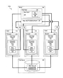
FIGURE lA illustrates schematically a first exemplary implementation of a
method for
gathering map usage data on multiple instances of a map distributed over a
network;
FIGURE 1B illustrates schematically a second exemplary implementation of a
method for
gathering map usage data on multiple instances of a map distributed over a
network;
- 4 -
CA 02876953 2015-01-08
FIGURE 1C shows an arrangement in which map interaction records for a
plurality of
individual map objects, each associated with a different web page hosted by a
different server,
can be collected and analyzed at a common server;
FIGURE 2 is a schematic block diagram showing an exemplary implementation of a
map
listener;
FIGURE 3 is a schematic block diagram illustrating an exemplary implementation
of a map
data processing engine;
FIGURE 4 is an exemplary visualization of exemplary analytic data showing, in
graphical
form, average load times for two map layers;
FIGURE 5 is an exemplary visualization of exemplary analytic data showing, in
graphical
form, general loading and activity data for users of instances of a particular
map object;
FIGURE 6 is an exemplary visualization of exemplary analytic data showing, in
graphical
form, the frequency with which users act on areas of embedded interactive maps
corresponding to particular locations on the Earth, presented by zoom level;
FIGURE 7 shows HTML code for a simple web page after integration of code for a
map
listener for a Leaflet.js map;
FIGURE 8 is a block diagram showing an illustrative computer system in respect
of which the
technology herein described may be implemented; and
FIGURE 9 is a block diagram showing an illustrative networked mobile wireless
telecommunication computing device in respect of which the technology herein
described
may be implemented.
DETAILED DESCRIPTION
[0017] Reference is now made to Figure 1A, which illustrates schematically a
first exemplary
implementation 100A of a method for gathering map usage data on multiple
instances of a
- 5 -
CA 02876953 2015-01-08
map distributed over a network, such as the Internet. Thus, although not shown
in the
Figures, one skilled in the art will appreciate that the various computers
will typically be
geographically remote from one another, and that communication among the
various
computers will typically be mediated by one or more networks, such as the
Internet.
[0018] In the first exemplary implementation 100A, a first server 102 stores a
master copy of
a web page 104. It is to be understood that the term "server", as used herein,
encompasses not
only a single computer acting as a server but also a plurality of computers,
possibly
geographically dispersed, together acting as a server. The web page 104 stored
on the first
server 102 includes a map object 106 associated with the web page 104 and
representing a
cartographic region of the Earth.
[0019] The term "map object", as used herein, refers to a digital cartographic
representation
of all or part of the Earth and which enables a user to interact with the
representation, such as
by panning, zooming and/or clicking, and in which the representation has
inbuilt cartographic
context awareness. Any map will have a pictorial linkage to the represented
region of the
Earth in that the map is a visual representation of the region according to a
cartographic
convention. A "map object" provides, in addition to the pictorial linkage to
the represented
region, inbuilt cartographic context awareness in the form of a dynamic
association between
screen position in a map display generated from an instance of the map object
and a
corresponding cartographic coordinate representing a position on the Earth.
Stated more
colloquially, a map object "knows" the correspondence between pixel positions
and real-
world cartographic positions. For example, in the context of a tiled web map,
the map object
can determine the real-world cartographic coordinate corresponding to a
particular pixel based
on the tiles that are currently displayed, which are dictated by the general
region and the zoom
level, and the screen position of the displayed tiles. A map object, although
initially centered
on a particular coordinate at a particular zoom level, will typically cover
the entire earth,
although a map object may cover a smaller cartographic region. Thus, a map
object will
typically be associated with a particular region of the Earth, with that
region being generally
defined by the initial centering coordinate and the initial zoom level.
- 6 -
CA 02876953 2015-01-08
[0020] In a tiled web map application, a map object will typically not include
copies of the
tiles, but will comprise instructions for retrieving (e.g. from a map server)
and displaying the
appropriate tiles as well as additional instructions for supporting user
interaction with the
map. For example, a map object for a tiled web map application may include
instructions for
retrieving and displaying an initial set of tiles as well as instructions for
retrieving and
displaying additional tiles in response to user pan or zoom commands, and may
also include
instructions for retrieving additional information when a user clicks on
particular areas of the
map.
[0021] Map objects are designed so that an instance of the map object can
execute on the
client side of a client-server relationship. In a presently preferred
embodiment, the map
object 106 is coded in a browser-executable language such as JavaScript and,
as shown in
Figure 1A, is included as part of the program code for the web page 104. The
map object 106
is included in the web page 104 in such a way that an instance of the web page
104 displayed
in a browser will include a corresponding instance of the map object for
presenting an
embedded interactive map. As such, an "instance" of a map object may be
understood as
being the client-side copy of the map object 106. The instance of the map
object, together
with the retrieved map data (e.g. tiles and any additional layers), are
presented by the web
page as an embedded interactive map covering the region of the Earth with
which the map
object is associated.
[0022] The web page 104 stored on the first server 102 encapsulates a map
listener 108. The
map listener 108 is a browser-executable software program for creating map
interaction
records, that is, records of how a user interacts with an embedded interactive
map, and a map
listener instance is an individual copy of a map listener. Thus, when an
instance of the web
page 104 is presented by a browser on a client computer, the associated map
listener instance
will execute within the browser to record the way the user interacts with the
corresponding
instance of the map object. The recorded user interactions will typically
include at least one
of user panning of the respective map ("pan events"), user zooming of the
respective map
("zoom events"), map extents, map center points and user click locations on
the respective
map ("click events"). Since the map object and hence each instance thereof has
inbuilt
- 7 -
CA 02876953 2015-01-08
cartographic context awareness, the recorded interactions can be
cartographically associated
with the region of the Earth represented by the map object.
[0023] As shown in Figure 1A, in a presently preferred embodiment, the map
listener 108 is
included with the browser-executable code for the map object 106. For example,
in a
presently preferred embodiment both the map object 106 and the map listener
108 are
implemented in JavaScript. A different map listener (i.e. a different
JavaScript library) will
be provided for each type of map object to be supported. For example, present
map object
formats include Google Maps API, LeafletJS, Openlayers3, Bing Maps and ESRI.js
and a
map listener can be provided for each; a map listener may be developed for any
suitable map
object format. Suitable map listeners for each type of supported map object
can be hosted on
a content delivery network along with guidance to assist developers in
selecting the
appropriate map listener for the type of map object that they wish to monitor.
[0024] In the first exemplary implementation 100A, a plurality of client
computers 110 have
requested the web page 104 from the first server 102, and the first server 102
has served an
instance (copy) 112 of the web page 104 to each client computer 110. Thus,
each client
computer 110 has a web page instance 112 executing within a browser 114
running on the
respective client computer 110. Each web page instance 112 presents a
respective instance of
an individual map object, that is, an instance of the map object 106, together
with
corresponding map data, as an embedded interactive map 116. More particularly,
each
instance of the map object 106 requests the appropriate tiles 118 from a map
server 120, and
then displays the served tiles in the respective embedded interactive map 116.
In the
illustrated embodiment, the map server 120 is separate and distinct from the
first server 102.
[0025] Each web page instance 112 encapsulates a map listener instance 122
executing within
the browser 114 on the respective client computer 110. Each map listener
instance 122
records user interactions with the respective embedded interactive map 116 in
the web page
106 and thereby generates map interaction records 124 for that client computer
110.
[0026] In the first exemplary implementation 100A shown in Figure 1A, the map
listener
instances 122 transmit the map interaction records 124 for the embedded
interactive maps 116
- 8 -
CA 02876953 2015-01-08
to a map data processing engine 126 on the first server 102, which receives
the map
interaction records 124 from the map listener instances 122 for further
processing as described
below. Thus, in Figure 1A, the map data processing engine 126 is located on
the same server
102 that serves the instances 112 of the web page 104 to each client computer
110. The
implementation 100A shown in Figure IA represents a case where a developer
manages
gathering and analysis of the map usage data directly by installing the map
data processing
engine 126 on the server 102 that the developer uses to host the web page 104.
The term
"developer", as used herein, refers to those who implement and/or manage web
pages that
present interactive maps (i.e. the web page 106 shown in Figure 1A).
[0027] Reference is now made to Figure 1B. Figure 1B is a schematic
illustration of a second
exemplary implementation 10013 of a method for gathering map usage data on
multiple
instances of a map distributed over a network such as the Internet. The second
exemplary
implementation 100B shown in Figure 1B is similar to the first exemplary
implementation
100A shown in Figure 1A, with like references denoting like features. The
second exemplary
implementation 100B shown in Figure 1B differs from the first exemplary
implementation
100A shown in Figure 1A in that in the second exemplary implementation 100B
shown in
Figure 1B, the web page 104 that encapsulates the map listener 108 is stored
on, and instances
112 of the web page 104 are served by, a second server 130 that is separate
and distinct from
the first server 102. In the illustrated embodiment, the map server 120 is
separate and distinct
from both the first server 102 and the second server 130. Thus, the map data
processing
engine 126 resides on the first server 102 and the web page 104 resides on the
second server
130. The implementation 100B shown in Figure 1B may be used as an architecture
preference where a developer manages gathering and analysis of the map usage
data directly
and controls both the first server 102 and the second server 130. The
implementation 100B
shown in Figure 1B may also be used where gathering and analysis of the map
usage data is
provided as a web-based service by a third party relative to the developer of
the web page
104.
[0028] More particularly, the implementation 100B shown in Figure 1B
facilitates an
arrangement in which map interaction records for a plurality of individual map
objects, each
- 9 -
CA 02876953 2015-01-08
associated with a different web page hosted by a different server, can be
collected and
analyzed at a common server. Thus, as shown in Figure 1C, the map data
processing engine
126 resides on a first server 102, and servers 130a...130n host respective web
pages
104a...104n each including a respective map object 106a...106n and
encapsulating a
respective map listener 108a...108n. Thus, there are a plurality of individual
map objects
106a...106n associated with a plurality of respective web pages web pages
104a... 104n.
Respective instances 112a...112n of the web pages 104a...104n are served to
respective
client computers 110a...11On, and the map listener instances 122a...122n
executing within
the browsers 114a...114n on the respective client computer 110a...11On
transmit respective
map interaction records 124a...124n to the data processing engine 126 on the
common first
server 102. The common first server 102 also hosts a web application 140, as
will be
described further below. Although only a single map server 120 is shown in
Figure 1C for
simplicity of illustration, it will be appreciated that the map data for the
embedded interactive
maps 116a...116n may come from a plurality of distinct map servers (e.g. if
different types of
map objects are used).
[0029] Reference is now made to Figure 2, which shows in schematic form an
exemplary
implementation of a map listener 108. The exemplary map listener 108 comprises
a client
listener 202, an analytic generalizer 204 and a communicator 206.
[0030] In the exemplary embodiment, the client listener 202 is a browser-
executable software
program; each instance of the client listener 202 interacts directly with the
instance of the map
object being monitored, that is, with the embedded interactive map 116 in the
web page 106
(Figures IA to 1C). The particular implementation of the client listener 202
will depend on
the format of the type of map object for which interactions are to be
monitored but in each
case the client listener 202 monitors ("listens") for and captures particular
events that occur
on the instance of the map object. These events include, but are not limited
to, pan events,
zoom events and click events.
[0031] Because each interactive map 116 is an instance of a map object which
has inbuilt
cartographic context awareness, at least some of the events captured are
cartographically
- 10 -
CA 02876953 2015-01-08
associated with the region of the Earth represented by that map object. More
particularly, not
only the event, but also the cartographic location of the event with respect
to the interactive
map 116, can be captured by way of the dynamic association between the screen
position in
the interactive map 116 and the corresponding real-world cartographic
coordinate. This
allows the analysis of user interaction with the maps to include a
"cartographic" perspective
by considering events that are not captured by traditional web analytics;
these events are
intrinsic to the performance of the map and how its users interact with it.
[0032] In an exemplary embodiment, the client listener 202 uses a tracker
prototype object to
construct records of the events being monitored. An exemplary implementation
of the tracker
to prototype object contains the following data attributes (with a
description/explanation of each
data attribute included in parentheses):
= track_id (to identify each web domain)
= Center (cartographic center of the event)
= Zoom (the zoom level of the event)
= map sa_id (to identify each map within a domain)
= sa id (to identify a layer within a map)
= Action (the type of activity)
= Category (category of analytic)
= Label (a label associated with a generic analytic capture)
= Value (the value of a generic analytic)
= Tilecenter (cartographic center of a tile)
= Tileurl (URL of a specific tile image, if necessary)
= map session id (to reference the session of the map)
= layer_session id (to reference the session of the layer)
= Timestamp (time at which event occurred)
[0033] In the exemplary embodiment, for each event, the instance of the client
listener 202
will capture the pertinent timestamps to enable a better understanding of the
duration of
events and thus of technical performance issues; implied from these events are
concepts such
- 11 -
CA 02876953 2015-01-08
as tile loading durations and error tiles. These events are tied back to
particular map objects
through the use of the common "track id", which identifies the web domain of a
map object
and the "said" which identifies a particular map object managed under the web
domain
identified by the "track id". In the illustrated embodiment, the "track id" is
programmatically generated by the first server 102, for example by the web
application 140,
and the "said" is generated by the developer. The timestamps also enable
developers to see
the number of users and the type of user interactions with the interactive web
maps at various
time intervals.
[0034] In the exemplary embodiment, the data attribute "Action" can be
assigned a value of
"Layerload", indicating that the data record contains layer loading data, a
value of
"Mapactivity", indicating that the data record contains map activity data, a
value of
"Tileerror", indicating that the data record contains data about tile loading
errors, or a value of
"Statechange", indicating that the data record contains data about a layer
session state change
(adding or removing a map layer). Also in the exemplary embodiment, the data
attribute
"Category" can be assigned a value of "Map", indicating that the data record
is for a map-
based analytic, a value of "Tlayer", indicating that the data record is for a
tile layer analytic,
or a value of "Layersession", indicating that the data record is for a layer
session-based
analytic.
[0035] In one implementation, the client listener 202 binds to the map object
and monitors
activities within that map object. Binding enables the client listener 202 to
add the "track id"
and "sa id" to a particular event or object for tracking purposes.
[0036] As noted above, a different map listener 108 will be provided for each
type of map
object to be supported, and the client listener 202 will be adapted to a
specific map object
type. In order to simplify the map analytics, and to facilitate comparisons
across different
types of map object, it is preferable for the map interaction records to have
a common data
format, rather than having a different data format for each type of supported
map object. The
analytic generalizer 204 receives the data captured by the client listener 202
and translates
that data into a common generic format that can be ingested by the processing
engine that
- 12 -
CA 02876953 2015-01-08
performs the map analytics (e.g. data analyzer 304 discussed below); the
analytic generalizer
204 thus functions as a generalization layer. In a preferred embodiment, since
the analytic
generalizer 204 is part of the map listener 108, instances of the analytic
generalizer 204 (each
part of an instance of the map listener 108) will execute on the client
computers 110, thereby
reducing bandwidth consumption. In other embodiments, generalization may be
provided on
the server side.
[0037] The communicator 206 receives the generalized data from the analytic
generalizer
204, prepares it, and then sends it to a server-side processing engine (e.g.
the map data
processing engine 126 on the first server 102) as a map interaction record. In
a preferred
embodiment, preparation of the generalized data includes compression to reduce
the payload
of the data sent the data receiver 302 (Figure 3), thereby reducing the client-
side bandwidth
requirement; any suitable compression algorithm may be used. The communicator
206 is
preferably configured to capture the IP address and device data for the
respective client
computers 110, 110a...11On and includes this information in the request
headers with the map
interaction record 124, 124a...124n (Figures IA to 1C). In the preferred
embodiment, the
captured device data includes "browser family", "browser version", "operating
system
family", "operating system version", "device family", "is mobile", "is
tablet", "is_desktop",
"is_touch_capable" and "is bot".
[0038] Reference is now made to Figure 3, which is a schematic block diagram
illustrating in
more detail an exemplary implementation of a map data processing engine 126
(which was
shown as a single block in Figures 1A to 1C). The map data processing engine
126 comprises
a data receiver 302, a data analyzer 304 and a data visualizer 306. In one
embodiment, the
map data processing engine 126 may be written in the PythonTM programming
language and
deployed on a scalable AmazonTM Web Services platform.
[0039] In the exemplary embodiment, the data receiver 302 functions as a
traffic controller,
and receives map interaction records 124 from the map listeners 108 (Figures
lA to 1C). The
data receiver 302 unpacks the compressed data 308 in the map interaction
records 124, as well
as the data in the request headers 310 (containing the IP address and device
data), and then
- 13 -
CA 02876953 2015-01-08
validates the received data and distributes the data to the relevant tables
312 in the data store
314. The data analyzer 304 accesses the tables 312 in the data store 314 to
take the stored
data as input to functions that apply the analytic logic and passes the
results to the data
visualizer 306, and the data visualizer 306 presents the results of the
analytic functions carried
out by data analyzer 304. In a preferred embodiment, the data analyzer 304 and
the data
visualizer 306 communicate with the web application 140 to receive requests
from, and
present the results of analytic functions to, developers. The use of a web
application can
facilitate other functions such as onboarding of new developers, management of
developer
accounts (including account settings), map setup and map management, as
described further
below.
[0040] The data visualizer 306 receives a request and then parses the request
and provides
instructions to the data analyzer 304 to execute the appropriate logic to
generate the analytics
specified by the request, after which the data analyzer 304 returns the
results to the data
visualizer 306 for formatting and presentation to the developer. In other
embodiments the
request may be passed directly to the data analyzer 304.
[0041] Each map interaction record 124 is associated with an instance of an
individual map
object, and hence each map interaction record 124 is associated with that
single map object.
This enables the analytics to be applied to each map object 106 individually.
Accordingly,
where there are a plurality of individual map objects 106a...106n associated
with a plurality
of respective web pages 104a...104n, as shown in Figure 1C, the map
interaction records
124a...124n can be analyzed separately for each individual map object
106a...106n so as to
produce meaningful results for the developer of the web page 104a...104n with
which a
particular map object 106a...106n is associated. Aggregated analysis of
multiple map objects
106a...106n to obtain broader metrics is also contemplated.
[0042] In a preferred embodiment, the analytics performed by the data analyzer
304 and
presented by the data visualizer 306 can be broadly characterized as falling
in one of two
general categories: technical performance analytics and user analytics.
- 14 -
CA 02876953 2015-01-08
[0043] The technical performance analytics pertain mainly to the loading speed
of key
cartographic elements like map tiles. Figure 4 is an exemplary visualization
of exemplary
analytic data showing, in graphical form, average load times for two map
layers. In addition
to loading speeds, the data analyzer 304 can also be configured to indicate
the presence of any
error tiles, and can report the cartographic location of those erroneous
tiles. Performance can
be assessed at the level of individual tiles, and this information can be
applied toward
improving the map serving environment.
[0044] The user analytics involve analysis of user data, that is, data about
how the users
interact with the embedded interactive maps 116. Some of the user data may be
cartographically agnostic. For example, Figure 5 is an exemplary visualization
of exemplary
analytic data showing, in graphical form, general loading and activity data
for users of
instances of a particular map object. The data shown in Figure 5 includes the
number of times
an individual map (as identified by the combination of "track id" and "said")
is loaded, the
average number of user interactions (activities) per load, the total number of
user interactions,
and the times of the earliest and most recent loads. The data shown in Figure
5 is
cartographically agnostic because, aside from the identity of the map object
itself (which is
associated with a region of the Earth), the user interactions represented by
that data do not
have any particular cartographic relationship with the region of the Earth
with which the
particular map object is associated.
[0045] Importantly, the user analytics can also include cartographic
information because the
map interaction records 124 include, for at least some of the captured user
interactions,
cartographic relationships between those user interactions and the region of
the Earth with
which the particular map object is associated. This is made possible by the
dynamic
association between screen position in a map display generated from an
instance of the map
object and a corresponding cartographic coordinate representing a position on
the Earth:
screen positions correspond to positions on the map, which in turn correspond
to coordinates
on the Earth.
- 15 -
CA 02876953 2015-01-08
[0046] The cartographic relationships between user interactions and the region
of the Earth
with which a map object is associated can take a variety of forms. For
example, the
cartographic coordinates of users' activities on the embedded interactive maps
can be
recorded; a user's interest in a particular part of a map may correlate with
an interest in the
corresponding region of the Earth. Recording the cartographic coordinates of
users' activities
on the embedded interactive maps is different from merely recording the screen
positions of a
user's interactions with a web page because in the context of an interactive
map, the same
screen position will correspond to different cartographic coordinates
depending on the zoom
level and pan position of the embedded interactive map. Figure 6 is an
exemplary
visualization of exemplary analytic data showing, in graphical form, the
frequency with which
users act on areas of embedded interactive maps corresponding to particular
locations on the
Earth, presented by zoom level. The visualization shown in Figure 6 is
presented in the form
of a "heatmap" but any magnitude-based visualization would be suitable to
indicate how users
interact with some geographic areas of a map significantly more than with
other geographic
areas of the map even though the size and shape of the map in consideration of
the webpage
itself remains constant.
[0047] Another cartographic relationship between user interactions and the
region of the
Earth with which a map object is associated is the relationship between a
user's actual
position on the Earth and a cartographic coordinate represented by a the
part(s) of the
embedded interactive map with which the user interacts. For example, a user's
approximate
physical location can be recorded in the map interaction record 124 (Figures
IA to 1C); this
physical location is related to the center of the map region displayed by the
embedded
interactive map at any given time, and also to the position on the Earth
corresponding to a
click location on the embedded interactive map. These relationships can be
used to create a
"map vector" in which the direction is measured from the bearing between the
approximate
physical location of the user(s) and the location on the map with which the
user is interacting
and the magnitude is the number of users interacting along that same bearing.
The
relationship between a user's actual position on the Earth and a cartographic
coordinate
represented by the part(s) of the embedded interactive map with which the user
interacts can
- 16 -
CA 02876953 2015-01-08
also be used to determine the average distance between users' locations and
the relevant
locations on the embedded interactive map.
[0048] Still further examples of cartographic relationships between user
interactions and the
region of the Earth with which a map object is associated include the
cartographic
relationships arising from the user interactions of panning, zooming and
combinations of
panning and zooming. The user interaction of panning on an embedded
interactive map has a
cartographic relationship with the region of the Earth with which the
corresponding map
object is associated because panning on the map correlates to moving from one
physical
location to another on the Earth. Similarly, the user interaction of zooming
on an embedded
interactive map has a cartographic relationship with the region of the Earth
with which the
corresponding map object is associated because zooming on the map is
correlated to selecting
larger or smaller regions of the Earth. Consistent panning actions by multiple
users may
indicate that the map object specifies a suboptimal initial center point for
the interactive map,
and consistent zooming actions by multiple users may indicate that the map
object specifies a
suboptimal initial zoom level for the interactive map. Consistent combinations
of zooming
and panning actions by multiple users may indicate that both the initial
center point and the
initial zoom level are suboptimal.
[0049] More generally, by determining the frequency and/or patterns of various
user
interactions with the embedded interactive maps, linkages between the user
interactions and
the user experience can be identified. For instance, a sudden zoom into a
location followed
by a sudden zoom out may indicate a user who misunderstands the control
mechanism of the
embedded interactive map. Thus, a specific sequence of particular user
interactions can
indicate a particular user experience, and a combination of particular map
layers being loaded
and particular user interactions being detected and recorded can indicate key
user experience
metrics. Visible layers can change how users interact with overlaid data
layers, for instance
users might click on markers more readily when they are overlaid on imagery
rather than a
cartographic fabric. Understanding how visible layers change a user's behavior
can be used to
improve the quality of a user's experience.
- 17 -
CA 02876953 2015-01-08
[0050] Analysis of user interactions, including initial user interactions and
specific sequences
of user interactions, together with their frequency, can be used to generate a
"map score"
representing the quality of interactive web maps, and hence the quality of the
corresponding
map object. The map score may be limited to usability factors, but preferably
will also take
into account technical performance analytics such as the response speeds of
the tile-based data
layers. In one embodiment, a generalized map performance matrix can be
developed, and a
particular interactive map/map object can be compared to that matrix to
determine the map
score. For example, a map performance matrix could include an expectation of
average tile
loading speed, or average activities per map load, and comparing the
particular interactive
map/map object in question to the map performance matrix would result in a
"map score".
[0051] As noted above, the implementation 100B shown in Figure 1B facilitates
an
arrangement in which map interaction records for a plurality of individual map
objects, each
associated with a different web page hosted by a different server, can be
collected and
analyzed at a common server 102, as shown in Figure 1C. As also noted above,
the data
visualizer 306 (Figure 3) may be implemented in conjunction with a web
application for use
by developers, and such a web application can facilitate functions such as
onboarding of new
developers, management of developer accounts (including account settings), map
setup and
map management. Thus, in one embodiment, as shown in Figure 1C, a web
application 140
can be hosted on the common first server 102. Developers can use the web
application 140 to
create an account, and then add a site record comprising a name and a domain
name. The
web application 140 then creates a "track id" identifier which is associated
with that web
domain. The developer can then access the appropriate JavaScript code for the
map listener
108 that corresponds with the type of map object 106 being used in the
developer's web page
104 and integrate the map listener 108 into the browser-executable code for
the map object
106.
[0052] Figure 7 shows the HTML code, indicated generally at reference 700, for
a simple
web page that includes an embedded Leaflet.js interactive map, after
integration of code for a
map listener for the Leafiet.js map. Lines 702 and 752 specify the document as
an HTML
document, and lines 706 to 716 contain the header for the HTML document; these
are
- 18 -
CA 02876953 2015-01-08
conventional and are not discussed further. Lines 718 to 750 contain the body
of the HTML
document. Line 720 contains a "div" element to position the embedded map in
the web page,
and lines 722 to 748 make up the map object. As noted above, in a presently
preferred
embodiment, the map listener 108 (Figures 1A to 2) is included in the browser-
executable
code for the map object 106.
[0053] Line 722 causes the browser to call and execute the JavaScript code for
presenting and
interacting with the map; this is conventional. Lines 724 and 726 cause the
browser to call
and execute the JavaScript code for the map listener 108. In particular,
"sliptics-analytics.js"
at line 724 is the general code, which is common for every instance of the map
listener 108,
and "sliptics-leaflet.js" at line 726 is the code that is specific to the
Leaflet.js interactive web
map library. Lines 728 and 748 specify that lines 730 to 746 are to be
executed by the
browser as JavaScript code. Lines 730 to 740 specify the details of the map to
be displayed,
and lines 742 to 746 cause the browser to retrieve tiles from the specified
tile layer, in this
case an OpenStreetMap tile layer. Lines 736 and 738 initialize the center of
the map and the
zoom level, respectively. Line 732 specifies the "track id" value associated
with the web
domain, and line 734 specifies a "said" value for the map (to differentiate
that map from any
other map attached to the same domain). In an embodiment, the individual map
layers can
also be differentiated, and the same method ("said") can be used for layer
differentiation. In
this embodiment, at the data store level the "sa id"s referring to maps are
identified as
"map said" and the "so id"s referring to layers are identified simply as
"said" to avoid
confusion. More than one map object be may be tracked for a single domain, for
purposes of
A/B testing to compare performance of different map objects, or simply because
the domain
includes more than one map object, for example a business web page may include
a different
map object for each location.
[0054] After the web page 104 has been modified to include the map listener
108,
subsequently served instances 112 of the web page 104 will cause the
respective browsers 114
to execute respective map listener instances 122, which will generate map
interaction records
124 and transmit them to the map data processing engine 126. The developer
will then be
able to access the analytics via the web application 140.
- 19 -
CA 02876953 2015-01-08
[0055] The present technology may be embodied within a system, a method, a
computer
program product or any combination thereof The computer program product may
include a
computer readable storage medium or media having computer readable program
instructions
thereon for causing a processor to carry out aspects of the present
technology. The computer
readable storage medium can be a tangible device that can retain and store
instructions for use
by an instruction execution device. The computer readable storage medium may
be, for
example, but is not limited to, an electronic storage device, a magnetic
storage device, an
optical storage device, an electromagnetic storage device, a semiconductor
storage device, or
any suitable combination of the foregoing.
[0056] A non-exhaustive list of more specific examples of the computer
readable storage
medium includes the following: a portable computer diskette, a hard disk, a
random access
memory (RAM), a read-only memory (ROM), an erasable programmable read-only
memory
(EPROM or Flash memory), a static random access memory (SRAM), a portable
compact
disc read-only memory (CD-ROM), a digital versatile disk (DVD), a memory
stick, a floppy
disk, a mechanically encoded device such as punch-cards or raised structures
in a groove
having instructions recorded thereon, and any suitable combination of the
foregoing. A
computer readable storage medium, as used herein, is not to be construed as
being transitory
signals per se, such as radio waves or other freely propagating
electromagnetic waves,
electromagnetic waves propagating through a waveguide or other transmission
media (e.g.,
light pulses passing through a fiber-optic cable), or electrical signals
transmitted through a
wire.
[0057] Computer readable program instructions described herein can be
downloaded to
respective computing/processing devices from a computer readable storage
medium or to an
external computer or external storage device via a network, for example, the
Internet, a local
area network, a wide area network and/or a wireless network. The network may
comprise
copper transmission cables, optical transmission fibers, wireless
transmission, routers,
firewalls, switches, gateway computers and/or edge servers. A network adapter
card or
network interface in each computing/processing device receives computer
readable program
instructions from the network and forwards the computer readable program
instructions for
- 20 -
CA 02876953 2015-01-08
storage in a computer readable storage medium within the respective
computing/processing
device.
[0058] Computer readable program instructions for carrying out operations of
the present
technology may be either source code or object code written in any combination
of one or
more programming languages, including an object oriented programming language
or a
conventional procedural programming language. The computer readable program
instructions
may execute entirely on the user's computer, partly on the user's computer, as
a stand-alone
software package, partly on the user's computer and partly on a remote
computer or entirely
on the remote computer or server. In the latter scenario, the remote computer
may be
connected to the user's computer through any type of network, including a
local area network
(LAN) or a wide area network (WAN), or the connection may be made to an
external
computer (for example, through the Internet using an Internet Service
Provider). In some
embodiments, electronic circuitry including, for example, programmable logic
circuitry, field-
programmable gate arrays (FPGA), or programmable logic arrays (PLA) may
execute the
computer readable program instructions by utilizing state information of the
computer
readable program instructions to personalize the electronic circuitry, in
order to implement
aspects of the present technology.
[0059] Aspects of the present technology have been described above with
reference to block
diagrams of methods, apparatus (systems) and computer program products
according to
various embodiments. In this regard, the block diagrams in the Figures
illustrate the
architecture, functionality, and operation of possible implementations of
systems, methods
and computer program products according to various embodiments of the present
technology.
For instance, each block in the block diagrams may represent a module,
segment, or portion
of instructions, which comprises one or more executable instructions for
implementing the
specified logical function(s). It should also be noted that, in some
alternative
implementations, the functions noted in the block may occur out of the order
noted in the
Figures. For example, two blocks shown in succession may, in fact, be executed
substantially
concurrently, or the blocks may sometimes be executed in the reverse order,
depending upon
the functionality involved. Some specific examples of the foregoing may have
been noted
- 21 -
CA 02876953 2015-01-08
above but any such noted examples are not necessarily the only such examples.
It will also be
noted that each block of the block diagrams, and combinations of blocks in the
block
diagrams, can be implemented by special purpose hardware-based systems that
perform the
specified functions or acts, or combinations of special purpose hardware and
computer
instructions.
[0060] It also will be understood that each block of the block diagrams, and
combinations of
blocks in the block diagrams, can be implemented by computer program
instructions. These
computer program instructions may be provided to a processor of a general
purpose computer,
special purpose computer, or other programmable data processing apparatus to
produce a
machine, such that the instructions, which execute via the processor of the
computer or other
programmable data processing apparatus, create means for implementing the
functions/acts
specified in the block diagram blocks.
[0061] These computer program instructions may also be stored in a computer
readable
medium that can direct a computer, other programmable data processing
apparatus, or other
devices to function in a particular manner, such that the instructions stored
in the computer
readable medium produce an article of manufacture including instructions which
implement
the function/act specified in the block diagram blocks. The computer program
instructions
may also be loaded onto a computer, other programmable data processing
apparatus, or other
devices to cause a series of operational steps to be performed on the
computer, other
programmable apparatus or other devices to produce a computer implemented
process such
that the instructions which execute on the computer or other programmable
apparatus provide
processes for implementing the functions/acts specified in the block diagram
blocks.
[0062] An illustrative computer system in respect of which the technology
herein described
may be implemented is presented as a block diagram in Figure 8. The
illustrative computer
system is denoted generally by reference numeral 800 and includes a display
802, input
devices in the form of keyboard 804A and pointing device 804B, computer 806
and external
devices 808. While pointing device 804B is depicted as a mouse, it will be
appreciated that
other types of pointing device may also be used.
- 22 -
CA 02876953 2015-01-08
[0063] The computer 806 may contain one or more processors or microprocessors,
such as a
central processing unit (CPU) 810. The CPU 810 performs arithmetic
calculations and control
functions to execute software stored in an internal memory 812, preferably
random access
memory (RAM) and/or read only memory (ROM), and possibly additional memory
814. The
additional memory 814 may include, for example, mass memory storage, hard disk
drives,
optical disk drives (including CD and DVD drives), magnetic disk drives,
magnetic tape
drives (including LTO, DLT, DAT and DCC), flash drives, program cartridges and
cartridge
interfaces such as those found in video game devices, removable memory chips
such as
EPROM or PROM, emerging storage media, such as holographic storage, or similar
storage
media as known in the art. This additional memory 814 may be physically
internal to the
computer 806, or external as shown in Figure 8, or both.
[0064] The computer system 800 may also include other similar means for
allowing computer
programs or other instructions to be loaded. Such means can include, for
example, a
communications interface 816 which allows software and data to be transferred
between the
computer system 800 and external systems and networks. Examples of
communications
interface 816 can include a modem, a network interface such as an Ethernet
card, a wireless
communication interface, or a serial or parallel communications port. Software
and data
transferred via communications interface 816 are in the form of signals which
can be
electronic, acoustic, electromagnetic, optical or other signals capable of
being received by
communications interface 816. Multiple interfaces, of course, can be provided
on a single
computer system 800.
[0065] Input and output to and from the computer 806 is administered by the
input/output
(I/O) interface 818. This I/O interface 818 administers control of the display
802, keyboard
804A, external devices 808 and other such components of the computer system
800. The
computer 806 also includes a graphical processing unit (GPU) 820. The latter
may also be
used for computational purposes as an adjunct to, or instead of, the (CPU)
810, for
mathematical calculations.
- 23 -
CA 02876953 2015-01-08
[0066] The various components of the computer system 800 are coupled to one
another either
directly or by coupling to suitable buses.
[0067] Aspects of the technology described herein can be applied to
interactive web maps
displayed on smartphones and similar devices. Figure 9 shows an exemplary
networked
mobile wireless telecommunication computing device in the form of a smartphone
900. The
smartphone 900 includes a display 902, an input device in the form of keyboard
904 and an
onboard computer system 906. The display 902 may be a touchscreen display and
thereby
serve as an additional input device, or as an alternative to the keyboard 904.
The onboard
computer system 906 comprises a central processing unit (CPU) 910 having one
or more
processors or microprocessors for performing arithmetic calculations and
control functions to
execute software stored in an internal memory 912, preferably random access
memory (RAM)
and/or read only memory (ROM), coupled to additional memory 914 which will
typically
comprise flash memory, which may be integrated into the smartphone 900 or may
comprise a
removable flash card, or both. The smartphone 900 also includes a
communications interface
916 which allows software and data to be transferred between the smartphone
900 and
external systems and networks. The communications interface 916 is coupled to
one or more
wireless communication modules 924, which will typically comprise a wireless
radio for
connecting to one or more of a cellular network, a wireless digital network or
a Wi-Fi
network. The communications interface 916 will also typically enable a wired
connection of
the smartphone 900 to an external computer system. A microphone 926 and
speaker 928 are
coupled to the onboard computer system 906 to support the telephone functions
managed by
the onboard computer system 906, and GPS receiver hardware 922 may also be
coupled to the
communications interface 916 to support navigation operations by the onboard
computer
system 906. Input and output to and from the onboard computer system 906 is
administered
by the input/output (I/O) interface 918, which administers control of the
display 902,
keyboard 904, microphone 926 and speaker 928. The onboard computer system 906
may also
include a separate graphical processing unit (GPU) 920. The various components
are coupled
to one another either directly or by coupling to suitable buses.
- 24 -
CA 02876953 2015-01-08
[0068] The term "computer system" and related terms, as used herein, is not
limited to any
particular type of computer system and encompasses servers, desktop computers,
laptop
computers, networked mobile wireless telecommunication computing devices such
as
smartphones, tablet computers, as well as other types of computer systems.
[0069] Thus, computer readable program code for implementing aspects of the
technology
described herein may be contained or stored in the memory 912 of the onboard
computer
system 906 of the smartphone 900 or the memory 812 of the computer 806, or on
a computer
usable or computer readable medium external to the onboard computer system 906
of the
smartphone 900 or the computer 806, or on any combination thereof.
[0070] Finally, the terminology used herein is for the purpose of describing
particular
embodiments only and is not intended to be limiting. As used herein, the
singular forms "a",
"an" and "the" are intended to include the plural forms as well, unless the
context clearly
indicates otherwise. It will be further understood that the terms "comprises"
and/or
"comprising," when used in this specification, specify the presence of stated
features,
integers, steps, operations, elements, and/or components, but do not preclude
the presence or
addition of one or more other features, integers, steps, operations, elements,
components,
and/or groups thereof.
[0071] The corresponding structures, materials, acts, and equivalents of all
means or step plus
function elements in the claims below are intended to include any structure,
material, or act
for performing the function in combination with other claimed elements as
specifically
claimed. The description has been presented for purposes of illustration and
description, but
is not intended to be exhaustive or limited to the form disclosed. Many
modifications and
variations will be apparent to those of ordinary skill in the art without
departing from the
scope of the claims. The embodiment was chosen and described in order to best
explain the
principles of the technology and the practical application, and to enable
others of ordinary
skill in the art to understand the technology for various embodiments with
various
modifications as are suited to the particular use contemplated.
- 25 -
CA 02876953 2015-01-08
[0072] A number of embodiments have been described by way of example. It will
be
apparent to persons skilled in the art that a number of variations and
modifications can be
made without departing from the scope of the claims. In construing the claims,
it is to be
understood that the use of a computer to implement the embodiments described
herein is
essential.
- 26 -