Note: Descriptions are shown in the official language in which they were submitted.
317~
BACKGROUND OF THE INVENTION
. . .
lo Field of the Invention
.
This invention relates to method and apparatus
for positioning or pointing a portable earth station
antenna system on a satellite in geo-synchronous orbit
and more particularly relates to such a system for
automatically positioning such an earth station
antenna from a remote location.
Recent satellite technology advances have placed
lU satellites utilizing microwave frequency transponders
in a geosynchronous orbit. In a geosynchronous orbit,
of course, the satellite remains over approximately
the same location on the earth surface, twenty-four
hours a day and-it appears motionless in the sky. The
use of extremely high frequency transmitters such as
Ku hand microwave transmitters in the 14.0-14.5
gigahertz frequency region has provided the ability to
reduce the size of parabolic dish antennas used to
communicate information from the surface of the earth
to the satellite and vice versa. With satellite
spacings on the order of 2 apart, along the
equatorial plane, it has become more and more
difficult to accurately point an antenna at the
correct satellite which it is desired to communicate
2~ with and to provide such communication without
intererence to other satellites.
, ' ` . ~ : `
.
~L26;~
In partic~llar, positioniny a small portable
antenna by relatively unskilled personnel in field
operations, such as in a well loyging environment, can
require that ~he specific direction of the radiated
signal from the antenna be held within plus or minus
one-tenth of a degree of the desired position. To set
up an antenna and to send and receive signals from a
geostationary satellite in a remote field location is
a relatively difficult procedure even when accomplish-
lu ed by highly skilled personnel. The general procedurenormally used by such highly skilled personnel would
be to point the antenna in the proper direction and
to verify that the correct satellite signal is being
received by using a spectrum analy7er. Pointing
re~uires the use of an accurate inclinometer and
compass.
In the present invention, however, a system is
provided for automatically positioning a portable
parabolic reflector antenna, which may be located, for
~0 example, on the top of a well logging truck, by
relatively unskilled personnel and completely automa-
tically under computer control. Before going to a
description of the system according to the present
invention, however, a brief description of the prior
art as known to the applicant is desirable.
. ~ .
~3~
2. DESCRIPTION OF THE_PRIOR ARI'
U.S. Patent 3,309,699 to Erdle relates to a
mobile tracking system for communication satellites.
A beacon signal developed by the satellite is used to
broadly point the antenna toward the satellite.
Accurate pointing is then achieved by interrogating
the amplitude of a return signal generated from a
signal transmitted to the satellite by the antenna
station. The Erdle patent, however, does not disclose
a method for aligning an antenna with a designated
satellite by maintaining a constant elevation angle
and scanning the azimuth angle automatically to peak
on a beacon signal.
U.S. Patent 3,378,345 to Welber discloses a
satellite tracking apparatus for continuously direct-
ing an antenna toward a satellite. A beacon signal is
generated with a particular frequency at an earth
station. The satellite reflects the signals back to
the earth station where the signal is processed by an
antenna drive system (auto track equipment 24~. The
specific operation of this system is not disclosed in
the Welber patent. However, the patent calls for
acquiring the satellite by radar equipment or
satellite orbital data; see, for example, Column 2,
25 lines 9-15.
U.S. Patent 3,434,142 to Andre, et al and U.S.
Patent 3,242,4~4 to Gicca are also of general interest
,~ .
~2~3~
for their disclosure of antenna position adjusting
systems with respect to the present invention.
However, neither of these patents disclose a system
having the capabilities of the system of the present
invention.
3~ RIEF DESCRIPTION OF THE INVENTION
A portable parabolic dish antenna carried on a
well logging truck is positioned automatically by a
portable computer system driving motors in a remote
loca~ion according to the concepts of the present
invention. Plural servo- motors may be used to drive
the portable parabolic antenna in azimuth and eleva-
tion. The portahle antenna may be, for example,
mounted on the roof of a well logging truck in
accordance with the concepts of the invention.
The earth latitude and longitude of the well site
is entered into the portable truck computer along with
the position of the desired satellite which it is to
be communicated with on the Ku band~ As the
geosynchronous satellite will be at a fixed elevation
angle relative to a given location, the portable
parabolic antenna (whose base has been reasonably
leveled) is adjusted by a computer to a pxedetermined
elevation angle and pointed by the computer in a
2~ predetermined general direction of the satellite
~i3~
heading in azimuth. While keep:ing the elevation angle
constant, the a~imuth angle is swept slowly under
computer control. The signal strength of the desired
satellite transponder is monitored at the known signal
frequency of the transponder. When the satellite
signal is detected, a satellite transponder beacon
channel is decoded to verify that the desired
satellite and the specific transponder is being
received. If the beacon signal does not decode, it is
lu assumed that the signals are not from the desired
satellite and the scan continued until the desired
satellite is found. This azimuthal sweep is per-
formed under computer control with equipment and
computer software or ~irmware as will be described in
more detail subsequently.
The invention may best be understood by reference
to the detailed description thereof when taken in
conjunction with the accompanying drawings. It will
be recognized that the drawings and description
included herein are submitted as descriptive of the
invention, but not limitative in that respect.
BRIEF DESCRIPTION OF THE DRAWINGS
.
Figure 1 is a schematic diagram showing a
satellite antenna positioning system in accordance
2~ with the invention in use in a well logging environ-
ment.
~Z63~
Figure 2 is a schematic block diagram illus-
trating truck borne hardware ancl software or firmware
equipment according to the concepts of the present
invention used for positioning a portable parabolic
dish antenna at a remote site.
Figure 3 is a flow chart diagram illustrating a
portion of the control computer programming of the
system of the present invention and
Figure 4 is a flow chart diagram illustrating a
portion of the control computer programming of the
present invention.
DESCRIPTION OF THE PREFERRED EMBODIMENT
Referring initially to Figure l, a satellite
antenna positioning system in accordance with the
concepts of the present invention is shown in a well
logging environment in a remote well site location. A
well logging truck 10 is supplied with armored logging
cable on a cable reel 12. The cable 13 connects via
sheave wheels 14 and 15 to a downhole well logging
20 sonde 20. The sonde 20 is suspended by the cable 13
in a well borehole 17 which is filled with a borehole
fluid 18. The downhole instrument 20 serves to
measure physical parameters of interest with respect
to the earth formations 19 in order to assist detect-
ing the presence of hydrocarbon in the earth
formations 19. The entire logging cable, sheave
wheel, and sonda apparatus is suspended in the borehole
17 via a draw works or derrick 16.
: .... ,,, ,; :
.
:, .. :. , .: . . :
79
A portable parabolic dish antenna 11 is shown
mounted on the roof of the well logging truck 10.
This antenna 11 is provided with a gimbal mount 21
which enables movement of antenna 11 in both azimuth
and elevation. The mount 21 is supplied, as will be
seen in more detail subsequently, with drive motors
capable of driving the antenna 11 in both azimuth and
elevation under control of a truck borne computer
carried in ~he truck 10.
The communication to be established between the
well logging truck 10 at the remote well site and a
central computer base, located at a fixed location
(for example, in a large city) are to be conducted
through a satellite (not shown) which has been placed
in a geosynchronous orbit above the surface of the
earth. In a geosynchronous orbit the satellite
appears to remain motionless over a fixed spot on the
earth's surface. The satellite therefore has a
predetermined azimuth and elevation angle which may be
computed in a conventional manner given the well site
latitude and longitude by the computer carried in the
well logging truck 10. These azimuth and elevation
data may be used to position the antenna 11 for
communication with the satellite by the truck 10.
Such satellites have been placed in
geosynchronous orbit recently utilizing approximately
...... :. . .::
. .
~LZ63~L79
14-15 gigahertz transponders on the sate:Llite for
communicating in the Ku band of microwave frequencies.
Wide band communications may thus be provided from the
well logging truck 10 at the remote site to a
centrally located computer system. Voice and data
link to the central computer system may be provided
over the relatively wide band transponder channel
provided by the geosynchronous satellite.
Earth formation measurements made by the downhole
well logging sonde or instxument 20 of Figure 1, may
be transmitted directly to the central computer system
for processing, or may be processed by a truck com-
puter located on the logging truck 10 and the process-
ed signals then transmitted to the satellite via the
antenna 11.
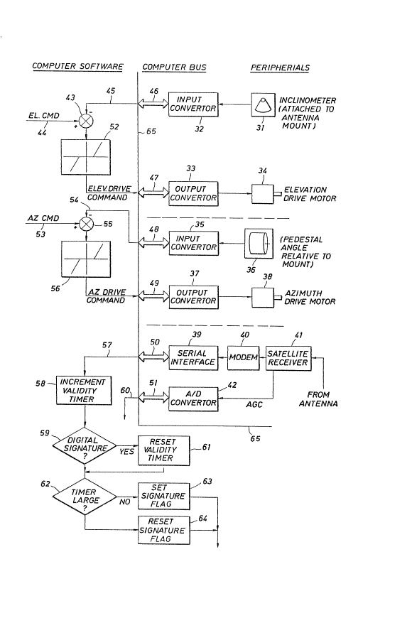
Referring now to Figure 2, the truck borne
system for directing the satellite antenna 11 of
Figure 1 is illustrated in more detail but still
schematically. This system is carried on the well
~0 logging truck 10 of Figure 1. A small general purpose
computer such as a Digital Equipment Co. of Cambridge,
Mass. model PDP-11/750- or the like and associated
peripheral equipment could be used. In Figure 2, the
portion to the left of line 65 refers to computer
software or microprocessor firmware and the portion to
the right of line 6$ refers to computer peripherals
and computer hardware.
,... ..,.. ~ ...
, . "
~2~31~
On the hardware side of line 65, we see that a
plurality of periphexal equipment are connected to the
general purpose computer carried in the logging truck
10. An elevation inclinometer 31 is used to detect
the angle of the antenna 11 with respect to the
vertical for elevation control. Signals from the
elevation inclinometer 31 are input by an input
converter 32 and the computer bus 46 into the computer
software or firmware where it is further processed in
the manner which will be described in morè detail
subsequently. Elevation drive command signals pro-
duced by the software or firmware program are output
on the computer bus 47 to an output converter 33 which
then drives the antenna 11 elevation drive motor 34.
Similarly, an azimuth drive channel of the antenna
system is controlled by computer software or firmware by
having a transducer 36 sense the pedestal angle
(relative to its mount) of the antenna 11 of Figure 1
and inputting this to the computer via an input
converter 35 and compu~er bus 48. An a2imuth drive
command signal is output via a computer bus 49 to an
output converter 37 and used to control an azimuth
drive motor 38 to drive the antenna in azimuth in a
manner which will be described in more detail subse-
quently.
.
. .
~2`~ 7~
The summation indicated at 43 of the inputsignals from lines 94 and 45 and applying the drive
logic to the elevation drive motor (as indicated in
block 52) on the software side of line 65 will be
described in more detail subsequently with respect to
Figures 3 and 4. Similarly, the generation of azimuth
dxive command signals will be described in more detail
subsequently. These commands are derived from the
pedestal angle input on line 54 to the summation 55
and the aæimuth command signals on line 53. The logic
portion of azimuth control is indicated at block 56.
The computer software or firmware described on
the left of line 65 in Figure 2 may be thought of as
real time computer software or firmware, in the sense
that it must monitor and respond to its input signals
as received from the transducer devices and a
satellite receiver 41 (which is mounted on the antenna
11 proper of Figure 1) to detect signals from the
satellite. The real time software portion o~ Figure 2
maybe thought of in three major sections. One such
section controlling elevation, a second section
controlling azimuth and a third section for detection
of the correct signal from the satellite. With
respect to this third section, the satellite receiver
41 detects 11.7-12.2 gigahertz signals from the
. ' ' .
3~
antenna ]l (Figure 1) and provides, via a modem 40 and
a serial interface 39 to computer bus 50, input
signals to the software or firmware program on line
57. Similarly, the satellite receiver 41 provides
automatic gain control signals which are indicative of
the strength or amplitude of the satellite signals via
an analog to digital converter 42 and computer bus 51
to the computer software or firmware programs, as
input on line 60.
The real-time portion of the software program for
monitoring the satellite signals to determine whether
a strong signal is being received and for decoding the
serial data from the receiver modem 40 to detect a
valid digital signature from the receiver is
illustrated schematically near the lower portion of
Figure 2. The valid digital signature monitoring
software comprises software for recogr.izing a pre-
determined digital signal or code which is supplied
from the central computer location via the satellite
to the antenna 11 on logging truck 10 of Figure 1.
This signal is used to determine that the antenna has
been correctly pointed at the proper satellite and
that the signal strength from the satellite has been
maximized prior to beginning of well logging data
transmission from the loyying truck 10 to the
satellite.
3~
The real-time software or firmware to the left of
line 65 in Figure 2 is entered under operation of a
real-time clock interrupt in the on board truck
computer. When the software or firmware is entered,
for example, at logic block 58 a validity timer i5
incremented. A test is then performed at logic block
59 to determine if the digital signature of the
desired satellite has been received on this entry. If
it has, a validity timer is reset at block 61 and
control is then passed to logic block 62, where a
timer magnitude test is performed. If a prescribed
period of time has elapsed, a digital signature flag
is set at logic block 64 and control is returned to
the operating system. If the timer large test at
block 62 fails then the signature flag is set at logic
block 63 and control is returned to the system.
Thus, it is seen that the computer software to
the left of line 65 of Figure 2 operates in real-time
to monitor the azimuth, elevation, signal strength and
to monitor the validity of the signal being received
from a particular satellite via antenna 11 of Figure
1.
Referring now to Figure 3 a non-real-time program
for controlling the scan of antenna 11 and generating
azimuth and elevation command signals for inputs on
lines 44 and 53 of Figure 2 is illustrated~ Entry
12
~ .
,
'
in~o logic block 71 of this program is made from the
operating system at initialization of antenna set up.
At logic block 71 the satellite elevation i5 computed
from the known coordinates (latitude and longitude) of
the well site location and the known location of the
satellite. Control is then passed to logic block 72
where a command pedestal azimuth signal to the left
gimbal limit is given. Control is then passed to
logic block 73 where a test is performed to see if the
azimuth is in place which the program has commanded.
This test is performed by comparing the present
azimuth location from the pedestal transducer 36 with
the command location. If the commanded azimuth has
not been reached, the program simply loops back and
continues to perform this test until it is. When the
azimuth in place test is passed,, control is transferr-
ed to logic block 74 where an elevation in place test
is performed. In performing this test, the actual
location o~ the elevation inclinometer 31 of Figure 2
- ~0 is compared with thQ commanded elevation. Control is
transferred back to logic block 74 until the commanded
elevation has been reached. When the commanded
elevation has been reached, control is transferred to
logic block 75 where an automatic gain control show
signal from A to D converter 42 is tested. This test
determines if the satellite antenna is presently
pointed at a satellite which is transmitting a signal
13
-
- ' - -
'' '
~L2~3~
s-trong enough for satellite receiver 41 of Figure 2 to
detect it. If it is not, control is transferred to
the delta step azimuth command logic block 78 which
increments the azimuth toward the right hand end of
the azimuth gimbal.
A test is performed at logic block 73 to deter-
mine if the gimbal angle has reached the extreme right
limit. If not, control is then transferred back to
logic block 73. When a signal has been detected at
logic block 75, control is transferred to logic block
76 which introduces a delay for a time sufficient to
receive the digital signal by a computer interface 50
on line 57 before transferring control to logic block
77. At block 77 a test is performed to determine if a
digital signature is present.
When the logic test at block 77 indicates a
digital signal is present, control is transferred to
the subroutine illustrated in more detail in Figure 4.
This routine locks the antenna onto the strongest
~0 signal. Upon entry at logic block 81, an initial pass
counter is set equal to zero. Control is then
transferred to block 82 where a yimbal step
gimbal azimuth ~ .1 signal is generated and control
is transferred to logic block 83. If this causes a
14
: ,
~63~7~3
signal AGC increase as detected at block 83, control
is transferred to logic block 86 where the azimuth
gimbal is stepped .1 and the test at block 87 is
entered to see if the AGC level continues to increase.
If it does, the azimuth is stepped another +.1 by
returning control to logic block 86. If not, control
is transferred to logic block 88 where the azimuth
gimbal is stepped -.05 and control is transferred to
logic block 90O If the test at logic block 83 has
failed, control is transferred to logic block 84 where
the azimuth gimbal is stepped a negative .~ and a
test performed at logic block 85 to determine if this
increases the AGC level. If it does increase the AGC
level, control is returned to logic block 84 and the
negative increment repeated. If the logic test at
block 85 fails, control i5 transferred to logic block
89 where the azimuth gimbal command is stepped .05 in
the positive direction and control is transferred to
logic block 90.
Similar logic is applied to the elevation command
signals beginning at logic block 90 where an elevation
step of positive +.1~ is commanded. Control is then-
transferred to logic block 91 where it is determined
whether this results in an automatic gain control
~5 (AGC) signal increase via input line 60 and computer
~Z6317~
~us 51. If this does result in an AGC increase,
control is transferred to logic block 92 where the
elevation command is stepped another +.1 and a test
is performed at logic block 93 to determine if this
results in an automatic gain control level increase.
If the test at logic bluck 93 is positive, control is
returned to logic block 92 and the process continued.
If it does not, control is transferred to logic block
94 where the elevation is stepped a -.05 and control
transferred to logic block 98.
If the test at logic block 91 fails initially the
elevation gimbal command is stepped -0.1 at logic
block 95 and control is transferred to the test at
logic bloc]c 96 to determine if this results in an AGC
1~ level increase. If it does, control is transferred
back to logic block 95. If it does not, control is
transferred to logic block 97 where the elevation
command signal is stepped +.05 and control
transferred to logic block 98. At logic block 98 the
2~ determination that the optimum gimbal positions have
been detected is made and the pass counter is
incremented. Control is then passed to logic block 99
where the pass counter is tested to determine i~ at
least three passes have been made through the entire
~5 program. I~ not, control is then returned to block 82
and the process continued. If the third pass has been
16
. -
,
, ` ' .~ .
3*~
made, then the antenna should be locked to the optimumangle for receiving the satellite and control is
returned to the real~time portion of the system.
Three passes are made because angular motion is not
commutative (i.e. a series of rotations does not
commute).
Thus, it may be seen that the software portion of
the antenna directing system of the present invention
starts an azimuthal scan when the elevation angle has
been reached which it is determined would be correct
for the satellite from the location of the well
logging truck 10. The azimuthal scan continues until
a particular satellite is sensed and the signal ~rom
that satellite optimized by making small changes in
lS elevation and azimuth until an optimually strong
signal is received. Control is then turned over to
the operating system for maintaining the antenna in
this direction by the real time program and the
communication link between the well logging truck 10
of Figure 1 and the central computer center is opened
for use.
Thus, it may be seen that the system of the
present invention provides method and apparatus for
accurately pointing a portable Ku band antenna located
~5 on a well logging truck at a remote location to a
particular geosynchronous satellite and for
establishing optimum signal conditions with the
satellite and opening the communications channel for
17
:: ,.
~i3~7~3
use by the truck equipment. This provides a
communications path for both digital information from
measurements made in the well borehole and voice
communications.
While the foregoing descriptions may make other
alternative embodiments of the invention apparent to
those skilled in the art, it is the aim of the append-
ed claims to cover all such changes and modifications
as fall within the true spirit and scope of the
invention.
18