Note: Descriptions are shown in the official language in which they were submitted.
~2~S~80
POSITION FINDING AND COLLISION AVOIDANCE SYSTEM
BACKGROUND OF THE INVENTION
This invention relates to position finding for
vehicles such as aircraft, particularly for collision
avoidance, using the standard Air Traffic Control Radio
Beacon System (ATCRBS) signals to determine the positions
of transponder-equipped stations within the service area
of a secondary surveillance radar (SSR).
Many collision avoidance systems using the ATCRBS
signals have been devised or proposed. 50me simply
provide an indication or alarm upon proximity of Own and
Other stations; some require active signal transmissions
for determination of range; others require uplink data
transmissions from ground-based equipment. All are
subject, to a greater or lesser extent, to production of
false alarms, or missed alarms or radio signal
interference, such failures occurring frequently under
congested airspace conditions were least tolerable.
Bearings from Own to Other stations, required for
effective manoeuvring to evade collision threats, have
heretofore been difficult to obtain; proposed airborne
directional antenna systems for this purpose have proven
to be too unreliable and costly to be practical.
While North pulse transmissions from SSRs can be
used to determine bearings, this invention avoids the
need for so-called North pulse kits to be installed.
More recently, a system meeting the needs of collision
avoidance under most prevalent conditions has been
successfully operated, as disclosed in our U.S. Patent
No. 4,768,036. However, that system is primarily useful
~27S4l~
only within the overlapping service areas of two or more
SSRs. Such areas usually e~ist where there is enough air
traffic to create an urgent need for collision avoidance
systems. However, in remote or undeveloped regions where
only one SSR may be active, there remains a need for an
improved collision avoidance system.
SUMMARY OF THE INVENTION
According to this invention, techniques disclosed in
U.S. Patent No. 4,021,802, and the patents referred to
therein, are used with stored data representative of the
locations and signatures of all, or an appropriate
selection, of existing SSRs to determine passively at an
Own Station the positions of any transponder-equipped
Other stations within an area of interest that is served
by at least one SSR. The position of Own station may be
det~rmined independently by on-board Loran C receiver
means, for example, or from the SSR interrogations and
replies elicited thereby from a transponder at a known
location.
BRIEF DESCRIPTION OF THE DRAWINGS
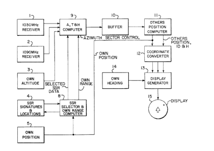
Figure 1 is a block diagram of a preferred
embodiment of the invention;
Figure 2 is a geometrical diagram used in explaining
the operation of the system in Figure l;
Figure 3 is a block diagram of a transponder
modified for use with the system of Figure 1 in an
alternative mode of operation; and
Figure 4 is a geometrical diagram used in explaining
the alternative mode of operation of the system of
Figure 4.
12~4~
DESCRIPTION OF EXEMPLARY EMBODIMENTS
Referring to Figure 1, the equipment of an Own
station, for example, aboard an aircraft, includes a
receiver 1 adapted to receive conventional ATCRBS
interrogations at 1030 M~z and to provide an output pulse
upon receiving each interrogation. A 1090 MHz receiver 2
is adapted to receive the replies of any transponders at
Other stations within its range, providing pulse outputs
corresponding to such replies. An altimeter 3 is
arranged to provide a signal representing Own's
barometric altitude.
A storage device 4, preferably a non-volatile
register such as a read-only memory (ROM), contains an
organized listing of all SSRs that might be used with the
system, including the signature and geographical location
of each.
The signature of an SSR is the unique combination of
main beam rotation period and pulse repetition
characteristic assigned to that particular SSR. The term
"characteristic" is used to account for the fact that
some SSRs are assigned fixed pulse repetition periods,
and others are assigned so-called "staggered" pulse
repetition periods, wherein the time between successive
interrogations varies in a predetermined sequence. Since
there are only a few thousand ATCRBS SSRs throughout the
world, it is readily feasible to store the signatures and
locations of all of them in the device 4 if desired.
Own's position finding means 5, which may be any
precision locating apparatus, such as a Global Satellite
Positioning System receiver or a Loran C receiver,
provides data representing Own's geographic location for
use by an SSR selector 8, which includas data comparator
means arranged in known manner to select, on the basis of
~27~4~
-- 4
Own's position and SSR positional data stored in device
4, a suitably located SSR within, for example, 100 miles
of Own's position. The signature and location of the
selected SSR are supplied to an A, T and H computer 9.
Selector 8 also includes means for computing own's range
from the selected SSR for use by the computer 9.
The interrogation-related pulses from receiver 1,
the Others reply-related pulses from receiver 2 and Own
altitude data from device 3 are also supplied as inputs
to computer 9, which may be essentially the same as shown
and described in U.S. Patent No. 4,021,802, with
reference to the upper three-quarters of Figure 3
thereof, specifically the elements designated therein by
the reference numerals 301-304 and 306-319.
The PRC selectors corresponding to elements 301 and
304 of said patent are adjusted by the SSR selector 8 to
accept the interrogations of the selected SSR and the
replies elicited thereby. The widened azimuth sector
gate, corresponding to element 310 of said patent, is
arranged to be controlled in inverse fashion by Own's
range from the selected SSR. For example, at a range of
100 miles, the azimuth sector may be the width of the SSR
beam, say three degrees. At lesser ranges, the azimuth
sector is increased, up to 60 degrees, for example, at
ranges of less than five miles.
The computer 9 operates in the manner described in
said Patent No. 4,021,802 to produce output data
representing the identity of each Other station within
the area of interest, and its differential azimuth ~,
~0 differential time of arrival T and differential altitude
H with respect to Own. Said data will appear in separate
bursts, sequentially as the SSR beam sweeps past Others'
positions.
~ ~7S4~
- 5
The data from computer 9 a;re stored as they become
available in a buffer device 10, which comprises a set of
registers, each arranged to store associatively the A, T
and H data relating to an identified Other station,
together with said Other's identity. As each such set of
data is completed, the buffer 10 presents it to a
position computer 11. When the computex 11 has completed
any ongoing calculation and is free to do so, it accepts
the presented data set, freeing the respective buffer
register for accumulation of another set.
The computer 11 may be a small general purpose
computer or a dedicated device, programmed to calculate
Others' positions by trigonometric operations on the
input data. Ordinarily it will complete the calculation
on a data set before a subsequent one becomes available.
Otherwise, the data is retained in the buffer until the
computer is ready to accept it.
Own's and Others' positional data, which may be in
latitude-longitude format, for example, with Others
tagged by identity codes, are supplied to a coordinate
converter 12 of known type. The converter produces
outputs representing ranges and bearings of identified
Others from Own. A display generator 13, also of known
type/ uses said outputs to produce signals for
controlling a display device 15, such as a cathode ray
tube, to exhibit Others' ranges/ bearings and identities.
Own's heading, obta~ned from a device 14 such as a
compass, may also be supplied to the generator to orient
the display with respect to Own's heading. Own's
positional coordinates, such as latitude and longitude,
may also be exhibited on display 15 for navigational use
by Own.
Figure 2 is a map-like representation of the known
positions of a selected SSR and Own station, and the
~2754~10
initially unknown position of an Other station. The
range R between Own and the SSR is provided by device 8.
The differential azimuth A of Other from Own is
determined by computer 9, as is also the differential
time of arrival T. The initially unknown ranges of Other
from the SSR and Own are designated S and Y,
respectively.
After accounting for systemic delays,
T = (S + Y - R) /c,
where c is the speed of radio propagation. From this
relationship and the known values of A and R, S and B may
be calculated using the law of cosines, and the angle
between lines S and Y determined. From this angle and
Own's known bearing from the SSR, Other's bearing from
Own is readily determinable. Said bearing may be
referred to Own's heading, using Own's compass.
Substantially any number of Other stations in the area of
interest are dealt with similarly, without requiring any
radio transmissions other than those occurring in the
normal operation of the ATCRBS system.
In some regions where there i5 SSR service,
collision avoidance may be desirable in the absence of
Loran C or similar navigational aids. In such instances,
Own's position may be obtained by means of a transponder
placed at a fixed known location such as a tower or a
mountain top in the area of interest. ~eferring to
Figure 3, a standard transponder including a 1030 MHz
receiver 31, interrogation decoder 32, reply encoder 33
and 1090 MHz transmitter 34 may be modified by adding a
pulse counter 35 to count the reply trigger pulses that
are produced by the decoder 32 and produce output pulses
only upon certain ones of the typical burst of, for
example, 18 interrogations that occur while the 5SR beam
~ Z754~
-- 7
passes, for example the second and sixteenth. These
pulses are used to trigger the reply encoder, so the
transponder will transmit only twice during a beam
passage, minimizing possible interference with ATCRBS.
An otherwise unused ID code and the location data of the
transponder are set in the encoder, for transmissions in
sequential replies. For example, the first r~ply during
each sweep of the SSR beam could be the assigned identity
and the second reply the magnitude of one of the
1~ transponder positional coordinates. These coordinates
may be expressed as latitude and longitude, or as range
and bearing from the SSR. Successive beam passages may
be used to transmit additional data such as the
transponder altitude, for example. The computer 11 of
Figure 1 may be arranged to exclude the fixed transponder
data, on the basis of its identity coding, from the
computations of Others' positions, to prevent confusion
with Others in its vicinity.
Referring to Figure 4, the fixed transponder FXT is
at a known range RX and bearing BX from the SSR. The
computers 9 and 11 are arranged to provide Own's
differential azimuth AX and differential time of arrival
TX from FXT, and calculate therefrom Own's range R and
bearing from the SSR. Using these data, Other's range Y
and bearing B are calculated as previously described.