Note: Descriptions are shown in the official language in which they were submitted.
A MAP WITH A HOMOGENEOUS GRID SYSTEM
BACKGROUND OF THE INVENTION
Field of the Invention
The present in~ention relates to a geographic
map with a homogeneous grid system on a flat or curved
support~
Description of the Prior Art
It is known that the earth, which may be
assimilated in a first approximation with a sphere of
radius R, is normally represented in plane images in
accordance with a considerable number of methods derived
from formulations of the general type :
XP = f(l,L)
YP = g(l,L)
where XP and YP are the plane coordinates, 1 is the longi-
tude and L is the latitude.
In order to facilitate map plotting andreferencing, a sphere grid network is also superimposed
on the map. The grid system or networX in most common
use corresponds to lines of constant longitude and of
constant latitude (meridians, parallels) which make it
possible to obtain coordinates usually designated as the
geographic coordinates.
Depending on the nature of the functions (f, g),
it is possible to have representations (commonly but
erroneously designated as projections) which are either
conformal (preservation of infinitesimal angles~, equi-
valent (preservation of areas) or aphylactic (in which
neither angles nor areas are retained).
For the purpose of map coverage of a region
having a small area, it is a customary practice to
define a single projection in which there are sometimes
formed a number of connectable interruptions or breaks,
the complete assembly being intended to constitute a
continuous representation (without either duplication or
tearin~) of the zone to be represented.
It is possible to construct a single projection
for the whole world but in this case certain portions are
inadequately represented : in particular, a single
conformal projection cannot represent the entire world
without singularity.
In the case of large areas and all the more so
in the case of the whole world, it is a common practice
to construct a projective system or in other words a
family of projections (in which the functions ~f, g)
differ only in respect of numerical coefficients), which
cover the region to be represented but with lines on
which the interruptions or breaks of two adjacent pro-
jections do not fit together.
The centers of the projections are adjusted by
virtue of considerations which are very different but are
o~ten determined as a function of the geographic
coordinates.
Among the representations, conformal pro-
jections are in very wide use since they represent the
terrain in a similitude of ratio K (scale) which, as a
general rule, is stationary on a central element (line
or point) and increases parabolically as the distance
from said central element is greater.
Plotting in a geographic coordinate system
(meridians, parallels) is fairly satisfactory-locally,
(in particular at the equator~ but becomes singular in
the polar regions. The meridians in fact converge in
the polar regions and the longitude becomes indeterminate.
Furthermore, the areas delimited by meridians and
parallels are relatively xectangular in the vicinity of
the equator and become triangular in the vicinity of the
poles, with the result that the subdivisions correspond
to elements having very variable areas or else to
elements having very different shapes if the procedure
adopted consists in regrouping.
It has already been sought to establish on the
terrestrial sphere grid systems forming substantially
equal areas, these areas being intended to permit sub-
division into grid meshes having areas which are in turn
substantially equal irrespective of the part of the
globe considered.
Among the methods proposed up to the present
time, the method which offers the highest degree of
fineness appears to have been given by Popko (1968)
(ref. : G.H. Dutton : Geodesic modeling of planetary
relief - Cartographica - Auto Carto Six - Selected
- papers - volume 21/Numbers 2 and 3 ; Sixth International
Symposium on Automated Cartography Ottawa - Hull,
October 16-21, 1983. University of Toronto Press -
1984 ; pages 192-193) which has proposed, among others,
the subdivision of a grid system of sixty equal
spherical isosceles triangles obtained for example by
gnomonic transfer to the sphere of the edges of the semi-
regular polyhedron of the second type which is circum-
scribed about the sphere and has sixty equal triangular
faces.
Starting from the initial grid system, it is
proposed to subdivide each triangle into four spherical
triangles by joining the midpoints of the sides by three
great-circle arcs, whereupon each triangle can subse-
quently be iteratively subdivided in accordance with thesame method. However, in each subdivision, the area of
the central triangle is larger than the area of the end
triangles. Furthermore, the method is not very simple
from a numerical standpoint.
3g~1
.
--5--
SUMMARY OF THE INVENTION
One object of the present invention is to
construct a grid sys-tem on the sphere for a cartographic
application in which the areas of the grid meshes are as
close in value as possible irrespective of the degree of
subdivision while also having shapes which are very
similar to each other.
In accordance with the invention, the
distinctive feature of the geographic map lies in the
fact that it has a grid system obtained by inverse
gnomonic transfer of a Romé de l'Isle polyhedron cir-
cumscribed about the sphere in accordance with local
transfers centered at the points of tangency of each
lozenge-shaped face of the polyhedron to the sphere.
It is recalled in this connection that the
Romé de l'Isle polyhedron is a semi-regular polyhedron
having thirty equal faces of lozenge shape in which the
vertices located at the ends of the major diagonals of
the lozenges correspond to the vertices of the icosahedron
and in which the vertices located at the ends of the
minor diagonals of the lozenges are projected to the
centers of the faces of the icosahedron. Thus the local
transfer of each lozenge centered at the point of
tangency to the sphere makes it possible to obtain on
said sphere an initial grid system of strictly identical
spherical lozenges.
In an advantageous embodiment of the invention,
each lozenge is subdivided into elementary quadrilaterals
by iterative dichotomy of each side by straight lines
parallel to the adjacent sides. Thus, in the polyhedron,
the elementary quadrilaterals are identical lozenges and
their transfer to the sphere in an inverse gnomonic pro-
jection makes it possible to obtain spherical quadri~
laterals of similar shapes by means of an extremely
simple numerical method.
According to a preferred aspect of the invention,
the lozenges of the Romé de l'Isle polyhedron are sub-
divided into elementary quadrilaterals, the vertices of
which are deEined by straight lines, the intersections of
said straight lines with the sides of the lo~enge being
determined by formulae of the polynomial type. Spherical
quadrilaterals having areas extremely close in value are
thus obtained on the sphere.
In a preferred embodiment of the invention,
each elementary quadrilateral is re-cut into pseudo-
triangles by arcs which are substantially parallel to the
minor diagonal of the lozenge and pass through the
vertices of the elementary quadrilaterals. Even finer
subdivision is thus obtained while preserving grid
meshes having extremely similar shapes and areas.
According to a further aspect of the invention,
a geographic map is designed with a grid system derived
-
~L2 ~ 9
--7--
from the sphere network defined earlier. In accordance
with a distinctive feature, the map grid system is
obtained from said sphere network by a projection of
part of said network. There is thus obtained on the map
a grid system which is of regular shape irrespective of
the point o~ the globe which serves as the center of
the map.
In an advantageous embodiment of the afore-
mentioned aspect of the invention in conjunction with a
sphere network in the form of pseudo-triangles, it is
possible to construct a projective system of simple but
redundant design by associating with each node of the
grid system the map which is centered at said node and
covers at least the polygon ~hexagon or pentagon) formed
by the pseudo-triangles, one of the vertices of which is
constituted by the node aforesaid : this is the principle
of ternary cartography. It will be possible in practice
to achieve an appreciable reduction in the number of
maps to be prepared by making a choice between these
maps which can be broken down into three categories. One
category corresponds to total coverage of the sphere
without any overlapping of polygons and includes the
twelve regular pentagons centered at the vertices of the
major diagonal of the spherical lozenges : this is the
principal coverage which will be carried out preferential-
ly. The other two categories ~known as secondary
coverages) each correspond to one total coverage of the
sphere but with a few lines of overlap of the constitu-
ent polygons. They are formed solely of hexagons and
include the hexagons centered at the vertices of the
minor diagonal of the fundamental spherical lozenges.
BRIEF DESCRIPTION ~F THE DRAWINGS
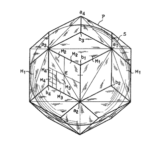
FIG. 1 is a front view of a Romé de l'Isle
polyhedron circumscribed about a sphere.
FIG. 2 is a pl~n view of one face of the Romé
de l'Isle plyhedron with a polynomial subdivision in
accordance with the invention.
FIG. 3 is a schematic perspective view of a
portion of sphere co~ered with the grid system in
accordance with the invention.
FIG. 4 shows one example of construction of a
map in accordance with the invention.
IG. 5 is a double-scale map forming part of
the principal coverage and centered on the equator.
FIG. 6 shows an example of construction of a
quadruple-scale map which is included in the map or
FIG. 4.
FIG. 7 shows another example of construction of
a map in accordance with the invention.
DESCRIPTION OF THE PREFERRED EMBODIMENTS
With reference to FIG. 1 and when consideration
; is given to a Romé de l'Isle polyhedron P or in other
. . .
words to a semi-regular polyhedron of the second type
having thirty identical 102enge-shaped faces and cir-
cumscribed about the sphere S with wh,ich the earth can
be assimilated, each face of the polyhedron is tangent
to the sphere at the center E of the lozenge which de-
limits each face or else at the point of intersection
of the diagonals of the lozenge for~ed by each face.
In accordance with the invention, a local
transfer is made from the central point E of each ~ace
of the ~omé de l'Isle polyhedron. In other worcls, each
point of the contour of one face is transferred to the
sphere along a radi~l line extending from the point
considered to the center of the sphere, the point of
; transfer to the sphere being the point of intersection
of said radial line with the surface of the sphere.
; If the references a1, a2, a3, -- al2
designate the vertices at the ends of the major diagonals
of the faces of the Romé de l'Isle polyhedron (which
correspond to the twelve vertices of the icosahedron
which is associated with said polyhedron, the icosahedron
associated with the polyhedron being represented by a
thin line in FIG. 1) and if the references bl, b2, b3, ...
b20 designate the vertices at the ends of the minor dia-
gonals of the faces of the Romé de l'Isle polyhedron
(which are projected to the centers of the faces of the
associated icosahedron), spherical lozenges are thus
--10--
obtained on the sphere and have vertices which are
located respectively at the points A1, A2, ... A12 and
1~ s2~ ... s20 (as shown in FIG. 3).
It is observed that the thirty spherical
lozenges obtained on the sphere are strictly identical
from the point of view of both shape and size, only the
orientation of these lozenges being variable.
The initial grid system which has just been
described will serve as a basis for subdivisions into
more or less numerous elementary grid meshes as a
function of the scale of the cartographic documents to
be compiled or else as a function of a desired density
of plotting on the sphere.
Provision is made in accordance with the
invention for a first mode of partition which consists
in subdividing each lozenge into elementary quadri-
laterals by iterative dichotomy of each side by straight
lines which are parallel to the adjacent sides. Thus,
at the time of each dichotomy of the sides, the starting
lozenge is divided into four strictly identical lozenges
which, at the time of a transfer by inverse gnomonic
projection having a center E,produce spherical quadri-
laterals of similar shapes on the sphere. The reference
Ml will be used hereinafter to designate the initial net-
work of thirty lozenges, the reference M2 will designatethe network obtained by re-cutting each side of the
~11--
lozenge in two or in other words by producing four
elementary quadrilaterals, the reference M3 wil7
designate -the network which is obtained by again sub-
dividing the preceding network by dichotomy of the sides
or in other words which is made up of sixteen elementary
quadrilaterals in the initial lozenge, and so on until
the network obtained and designated by the reference Mn
corresponas to partition of each side of the initial
lozenge into 2n 1 or in other words is made up of 22n 2
elementary quadrilaterals in an initial lozenge. FIG. l
illustrates a plurality of lozenges in accordance with
the network system M1 and a lozenge which is partially
divided so as to form the networks M2, M3 and M~.
Xt i5 worthy of note that the initial network
and the subdivided network which has just been described
are transferred to the sphere along great-circle arcs and
: it is therefore particularly easy to draw an arc from two
points.
The breakdown described in the foregoing con-
stitutes a primary approach to the problem and can be
used in certain cases on account of its very great
numerical simplicity. At the time of transfer by
gnomonic projection having a center E, however, it is
apparent that the elementary quadrilaterals are more or
less deformed as a function of the distance between said
quadrilaterals and the point of tangency E of the face of
~2
~12~
the polyhedron. It has therefore been endeavored to find
a method of subdivision which makes it possible to o~tain
much more strictly similar areas on the sphere. It is
therefore proposed in accordance with the invention to
subdivide each lozenge into elementary quadrilaterals,
the vertices of which are defined by straight lines, the
intersections of said straight lines with the sides of
the lozenge being determined by polynomial formulae. In
particular, in a first embodiment illustrated in FIG. 2,
the intersections (lk, qj) with the sides of the lozenge
are determined by the following formulae :
a21k = l-g~-T) (1)
b21k = g(T) (2)
a2q = l-g(-t) (33
b1qi g(t) (4)
where a2 is a vertex at one end of the major diagonal of
the lozenge ;
b1 and b2 are the vertices at the ends of the minor
diagonal of the lozenge ;
; 20 g(T) = 0.5+T+(T -0.25)(vo+v1T+v2T2+v3T3) (5)
g(t) = 0.5+t+~t2-0.25)(vo+v1t+v2t2+v3t3) ~6)
vO = 0.07215444
v1 = 0.229157
V2 = 0.026875
V3 = 0.080845
T being of the form T = Nk _ 0.5
-13-
t being of the form t = l ~ 0.5
where NL is the whole number of subdivisions sought for
one side ;
] and k are whole numbers which vary from 1 to NL ;
a2 lk~ b2 lk~ a2 q;/ bl qj being the fractions of the
length of side of the lozenge which are transferred to
the sidas of the lozenge respectively from the vertices
a2 ~ b2 ~ a2 ~ bl -
The network obtained in a binary subdivision
defined by NL = 2n 1 will be designated as before by the
reference Mn.
It has been found by experiment that, with this
type of subdivision of the faces of a Romé de l'Isle
polyhedron prior to transfer of said faces to the sphere,
the lines of partition on the sphere continue to be
great-circle arcs and the ratio between the area of the
largest elementary spherical quadrilateral and the area
of the smallest elementary spherical quadrilateral
remains smaller than 1.01.
In another mode of subdivision which is even
more accurate but in which the separating lines on the
sphere are no longer great-circle arcs, functions of T
and t are added to the polynomials glT~ and glt), thus
introducing a small correlation between these two para-
meters. It is thus possible to produce equal areas at
any level of subdivision. Nevertheless, it is preferred
-14-
in practical applications to adopt a formulation which
remains simple. By way of example, g(T) and g(t) become
respectively :
h(T, t) = g(T)+uT(T -0.25)(t -0~25) (7)
h(t, ~) = g~t)+ut(T2-0.25)(t2-0.25~ (8)
with
vO = 0.0721544
vl = 0.222360
V2 = 0.026089
V3 = 0.085626
u = -0.049765
T and t retain the same meaning as before. The
ratio of the largest area of the spherical quadrilateral
to the smallest area in respect of any given partition
or subdivision given by NL remains smaller than 1.001.
In order to plot a point on the grid system
thus formed, graduations having values T and t and
: extending successively from -0.5 at the points bl or b2
to +0.5 at the points al or a2 are marked on the sides of
the lozenge at the points of intersection (lk,qj) of the
subdivision lines with the sides of the lozenge. rl'his
graduated scale is repeated identically on the sixty
edges of the Romé de l'Isle polyhedron and can be repro-
duced on any spherical or cartographic image of these
edges. However, it should be noted that, in order to
produce a predetermined separating line (T - 0.375, for
~15-
example) in a lozenge, it is necessary to connect two
opposite graduation points (I' = 0.375 on b2al and
T = -0.375 on bla2). For reasons of a practical order,
it will be found necessary within each lozenge to sub-
stitute for the graduated scale of values (T,t~ agraduated scale which is better suited to this lozenge.
In practice, a division into (NLxNL) quadrilaterals will
produce a number sequence related to k (from 0 to NL~ on
the respective sides a2b1, b2a1 and will produce a number
sequence related to j from 0 to NL on the respective
sides blal, a2b2-
Finally, it will be possible to replace one of
these graduated scales by an alphabetical coding sequence.
Thus a subdivision into sixty-four quadrilaterals (corre-
sponding to three dichotomies of the sides) can bedesignated by the cartesian proauct
(A,B,C,D,E,F,G,H,I) x (0,1,2,3,4,5,6,7,8)
assigned to its eighty-one vertices.
Any subdivision into pseudo-lozenge quadri-
laterals (numbering NL x NL) results in the poss:ibilityof an associated subdivision in triangles (in twice the
number). This result is obtained by re-cutting each
quadrilateral into two triangles having very similar
areas by an arc which is substantially parallel to the
minor diagonal of the initial lozenge and joins two
adjacent quadrilateral vertices.
-16-
The network or grid system obtained is illus-
trated in the lower half of FIG. 2.
Numerically, the equation of each continuous
line of separating arcs is very simple :
T+t = constant
The separating arc is slightly convex towards
the lozenge diagonal which is in turn a great-circle arc.
It is apparent from the lower half of FIG. 2
that the same division into triangles is obtained by sub-
dividing each of the two initial triangles of the type
blb2a2 into four triangles defined by three lines
T = constant, t = constant and T+t = constant which pass
approximately through the midpoint of the sides of the
starting triangle, each triangle obtained being re-
subdivided in accordance with the same method.
There is thus obtained a hierarchized breakdown
into triangles of the sphere, starting from sixty equal
fundamental triangles, ~ach of which can be subdivided
indefinitely in a system of base 4.
This possibility can be extremely valuable in a
very wide range of applications, (particularly in
statistical evaluations at the surface of the earth).
In order to recall the non-spherical character
of the triangles defined in the foregoing, they will
hereinafter be designated as pseudo-triangles.
According to the second aspect of the
~L2~
invention, a geographic map .is prepared with a grid
system derived from the network of the sphere which has
just been described by constructing a pro]ection of a
portion of the sphere network corresponding to the
desired map and preferably a radial projection centered
at one point of the network, in particular a stereo-
graphic projection.
By way of example, it is proposed to position
- the sphere network described in the foregoing with respect
to the earth by coinciding the transfer of one vertex of
the Romé de l'Isle polyhedron located at the end of a
major diagonal of a lozenge with the north pole. The
point of transfer of the opposite vertex accordingly
coincides with the south pole and the different points of
transfer of the vertices of the Romé de l'Isle polyhedron
which correspond to the vertices of the associated icosa-
hedron are arranged in accordance with the following
` table :
Lon~itude Latitude
20 South pole -90
North pole +90
South Pacific -144 -26.5651
North America -108 +26-5651
South America -72 -26a-5651
North Atlantic -36 +26-5651
South Atlantic 0 -26-5651
~ 2~
-18-
Lon~itude Latitud~
Middle East +36 +26.5651
Indian Ocean +72 -26.5651
Far East -~108 +26.5651
5 Australia -~144 -26.5651
North Pacific +180 +26.5651
On the basis of this workiny hypothesis, the
positions of the other distinctive points of the system
are noted :
Image points of the vertices b of the lozenges : 5 points
at each of the latitudes +52.6226 ; ~10.8123 ;
- _
Center points E of the lozenges : 10 equatorial points,
5 points at each of the latitudes +58.2825 ; +31. 7175.
.~ When the grid system is thus positioned with
respect to the earth (globe), FIG. 4 illustrates the map
obtained by means of a stereographic projection centered
at the point Cl, the map being provided with a grid
system of the type designated as Ml. FIG. 5 is a double-
scale map which is centered in this case at C2 and pro-
vided with a grid system of type M2, this system being
re-cut partially into pseudo-triangles. FIG. 6 is drawn
to a scale which is double that of FI~. 5 and centered at
C3, the grid system oE this map being of type M3 and also
re-cut into pseudo~triangles. ~The points Cl and C3 are
at a latitude of 52.6226 7 the point C2 is a lozenge
center located on the equator at a longitude equal to 126~.
~L21~
--19--
When compiling a gnomonic map centered at a
point E which is the center of a lozenge tas shown in
FIG. 5), the coordinates (x, y) of any point of the map
along oblique axes Ex, Ey which have their origin at the
point E and extend in a direction parallel to the sides
of the lozenge (as shown in FIG. 2) can be readily
obtained from the coordinates (T, t) of the same point by
solving the following equations ~valid on the sphere of
radius 0.5) :
y-2x P(T) = I~T) (g)
-2y P~t)-~x = I(t) (10)
with
P (T~ = (vo-~v2T ) (T - O. 25) (l:L)
P(t) - (vo+v2t2~(t2-0.25) (12)
ItT) = 0.36327126 C T+(vlT~v3T3)(T2-o.25) ~ (13)
I(t) = 0.36327126 ~ t~(vlt~v3t3)(t2-0.25) ~ ~14)
: where vO, v1, v2, V3 are the same coefficients as in the
case of formulae (5) and (6).
It is observed that these equations are very
straightforward and in particular that they do not contain
any trigonometric formula, with the result that they can
be solved very rapidly, which is essential in data-
processing applications.
Similarly, the gnomonic coordinates (XG, YG) in
a reference frame which has its origin at the point E and
the axes of which are oriented respectively along the
-20-
minor diagonal and the major diagonal of the lozenge
(FIG. 2) are given by the following equations :
-XG Cos 2 C1-~2P(T)~ + YG sin c2 C1-2P(T)~ = I(T) sinc (15)
XG Cos 2 ~1+2P(t)~ + YG sin c2 ~1-2P(t)~ = I(t) sinc (16)
where c is the angle at the center corresponding to one
side of the isocahedron and consequently has the value
c = 63~349488.
These equations are the equations of two
straight lines and consequently involve a transition from
the coordinates (T, t) to the gnomonic coordinates (XG,
YG) through the intersection of two straight lines.
Similarly, there is a transition from the
coordinates (T, t) to the stereographic coordinates (XS,
YS~ in a reference frame which is centered at E and
directed along the diagonals of the lozenge by means of
the following formulae :
A(T~ (XS +YS )-XSCos 2 C1+2P(TD +YS sinC2 C1-2P(TD =F(T) (17)
A(t)(XS +YS )+XSCos2 ~1+2P(t~ +YSsin2 ~1-2P(t)3 =F(t) (18)
A(T) = F(T) = I(T~ sin c ; A(t) = F(t) = I(t) sin c
Equations (17) and (18~ are the equations of two circles
and therefore involve a transition from the coordinates
(T, t) to the coordirlates (XS, YS) through the inter-
section of two circles.
The adoption of the most accurate formulae
would be implemented by adding polynomial corrective
terms with two variables (T, t~ to the second expressions
-21
of equations (9), (10) and (15) to (1~) and would entail
calculations which are slightlylonger but of the same
nature.
It is also pointed out that a formulation
without any correlation between the variables (T, t) can
be obtained from the formulae (17~ and (18). Postulating
that A~T) ~ F(T), A(t) ~ F(t), there are thus obtained
equations in stereographic projection of circles which
are no longer images of great circles of the sph~re but small
circles of this surface. The intersection of these
circles as modulated by ~he parameters (T, t) makes it
; possible by suitably selecting the coefficients of the
~ormulae to construct a grid system based on circles on
the sphere and in stereographlc projection. This grid
system in fact bears a very close resemblance to the
system defined on the basis of the gnomonic projection
in the case referred-to as the most accurate working
hypothesis.
In all cases, the ratio r between the area of
an elementary figure of the sphere and the area of its
image in the corresponding plane (T, t) is a function
which is easy to calculate, whieh is continuous over the
entire sphere and whieh ean in addition be derived within
each of the thirty fundamental lozenges. Making allowance
for a eonstant factor, the value which has been adopted
for this ratio is 1.003000 at the point E, 1.005000 at
-22-
the vertices of the lozenge, and 0.995161 at the mid-
points of the sides Iformulae (5) and (6)). In the most
accurate modes (in which the separating lines are no
longer great-circle lines), it has been possible to adopt
a value r = 1.000000 at each of the points which have
just been mentioned.
The properties established in the reference
frames centered at E are generally applicable to other
origins. Thus the formulae of transition between
gnomonic reference frames are homographic formulae of
real variables which preserve the straight lines. The
formulae of transition between stereographic reference
frames are homographic formulae of complex variables
which preserve the circles.
The transition of coordinates of the type (XG,
YG) to geographic coordinates ~1, ~ is produced by means
of the terrestrial caxtesian coordinates CU, V, W~ , a
transition from CXG; YG ; 0.5 ~ to ~U, V, W3 accord-
ingly takes place by means of a three-dimensional rotation
followed by a homothetic correspondence on the result
vector in order to bring this latter back to the length R.
The values (1, L) are then found by inversion of the
formulae :
U = R cos L cos l; V = R cos L sin l; W = R sin L
In the foregoing developments, consideration
has been given to axes directed along the diagonals of the
~23-
lozenge. It is known, however, that in a Romé de l'Isle
polyhedron, the lozenges are oriented in di~ferent
directions. In order to facilitate reading of maps and
to ensure homogeneous orien-tation of these latter, it is
proposed in accordance with the invention to carry out
regrouping of the pseudo-triangles obtained by subdivision
of the elementary quadrilaterals in the form of polygons
centered at a vertex which is common to a number of
pseudo-triangles.
FIG. 3 illustrates one way in which the pseudo-
triangles can be regrouped in a grid system of the type
designated as M3. The initial regrouping centers are
; constituted by the vertices of type A (for example A1)
located at the ends of a major diagonal of a lozenge and
also corresponding to the vertices of the icosahedron
associated with the Romé de l'Isle polyhedron. It is
observed that five pseudo-triangles surround a vertex of
type A and the polygon ohtained by regrouping is there-
~ore a pentagon.
Consideration is accordingly given to the
pseudo-lozenge obtained by joining a pseudo-triangle
adjacent to a type-A vertex with an immediately adjacent
pseudo-triangle which is contiguous thereto on the side
opposite to the initial regrouping center. The end of
the ma~or diagonal of the pseudo-lozenge thus obtained
corresponds to a new regrouping center (for example Rl in
-24-
FIG. 3). This regrouping center is in turn surrounded by
six pseudo-triangles which therefore form a hexagon.
Starting from the regrouping center thus determined, an
iterative operation is performed by again starting from
the end of the major diagonal of a pseudo-lozenge
obtained by joining a pseudo-triangle adjacent to the
initial regrouping center with the immediately adjacent
pseudo-triangle which is contiguous thereto on the side
opposite to the initial regrouping centerO For example,
with reference to FIG. 3, the regrouping centers R2 and
R3 are obtained from the regrouping center R1.
As also illustrated in FIG. 3, the pseudo-
triangles are represented by a dashed lines whilst a
thick line indicates the polygons and a continuous thin
line represents the contour of the initial lozenges.
In FIG. 2, the regrouping centers are indicated
by a small circle (o) in the network M4.
; It is observed that, irrespective of the degree
of subdivision, the center E of the initial lozenge is a
regrouping center tfor example the center R3 in FIG. 3).
Starting from one end of the major diagonal of
a lozenge, it is found that the entire sphere is thus
covered with a series of contiguous polygons without any
overlap. When preparing a series of maps which utili~e
the projection of a polygon in each case, this series of
maps can be of constant size, thus permitting easy
-25-
position-find~ng when changing from one map ~o another.
This property is particularly advantageous in th~ case of
visua] display of maps on a cathode-ray screen.
The regrouping operation described in the
foregoing constitutes a procedure which will be
designated as the principal coverage and makes it
possible to cover the entire earth with a series of poly-
gons without overlap. It is also possible to start ~rom
a regrouping center formed by a type-B vertex located at
the Pnd of a minor diagonal of an initial lozenge. In
this case, the starting polygon is a hexagon but the
successive determination of regrouping centers in
accordance with the method described earlier results in
overlapping of the polygons when rotating abou-t a vertex
of type A. It is thus possible to construct two secondary
coverages each covering the entire surface of the earth
- but in this case with overlapping of certain portions.
The use of a secondary coverage will therefore be prefer-
ably reserved for cases in which the map center formed by
the principal coverage may not prove satisfactory for the
purpose of obtaining a good representation of the region
of the earth under consideration.
Conventional stereographic maps with north and
south poles form part of the principal coverage in the
case of all grid systems. FIG. 5 shows one example of a
principal-coverage map centered at ~l = 126, L = 0) in
-26-
the case of the grid network M2. This center is present
on all the larger-scale maps of the principal coverage.
FIGS. 4 and 6 give examples of maps of a secondary
coverage in the case of the grid networks M1 and M3
respectively.
The most complete cartographic objective in the
case of a given grid system is to center all maps at the
nodes of the network so that each map covers at least the
polygon whose origin is a regrouping center ~in either
principal or secondary coverage). The projective system
thus obtained constitutes what is known as ternary carto-
graphy in which each triangle is represented three times.
This is a redundant solution to the cartographic problem
but may usefully be contemplated, first of all because
it constitutes for a given problem a choice of realizable
maps which is already very selective, secondly because
the excessive cost of this complete solution will
gradually cease from being prohibitive (additional
redundancy in reqard to documents presented by visual
display does not need to be provided in cartographic data
banks), and lastly because it constitutes an advantageous
concept while offering interesting possibilities in
continuous display technologies.
In practice, preference is given to stereo-
graphic projection as a type of representation associatedwith the grid system described in the case of a sphere in
-27-
view of the fact that it is the best conformal represent-
ation in a circular field and that moderation in the
variation of its scale factor permits representation in
the same format of the 32 maps related to the grid net-
work Ml (twel~e principal-coverage maps, twenty secondary-
,!,` coverage maps) at a scale El, the 122 maps related to the
network M2 (forty-two principal-coverage maps including
two polar charts and ten equatorial charts, and eighty
secondary-coverage maps) at the scale 2E1 ; the 482 maps
related to the network M3 at the scale 4E1, and so on.
The series of projective systems thus mentioned is in
principle indefinite in the vicinity oE large scales and
is completed in the vicinity of small scales (at the
scale E21) by twelve maps centered at the vertices of the
icosahedron and each covering (in the same format) the
spherical pentagon whose origin is at the center of the
map and whose five vertices are the adjacent vertices of
the icosahedron. The corresponding grid network can be
designated as Mo.
Properties which have been little recognized up
to the present time may be mentioned in favor of this
projection. These properties permit precise and rapid
; computations of a number of different elements : distance
and azimuths between points from projection coordinates,
segmentation of a great-circle line into proportional
: parts, and finally the fact that this projection is the
-28-
component in the horizontal plane of a simple three-
dimensional transformation (inversion) and that this
property endows the projection with advantageous
possibilities in the field of geodesy, especially in
three-dimensional representation of the local gravita-
tional field~
Apart from the polystereographic system, the
circular field of each map is also conducive to the need
for polycentric representations of the radial type, in
particular the gnomonic projection, azimuthal pxojection,
cylindrical projection, radial equivalent projection,
perspective projection from a satellite. These repre-
sentations can in particular perform a useful function in
cathode-ray screen display and can be calculated on
request on the basis of the stereographic projection
having the same center.
The gnomonic projection, which has the well-
known property of representing great-circle arcs along
segments of straight lines, is often favorable but
e~hibits unacceptable scale distortions in low-inde~ grid
networks (Mol Ml, M2) in cases in which stereographic
representation always remains very suitable for use.
~ s will readily be understood, the invention
is not limited to the embodiments described in the fore-
going and any alternative forms of construction mayaccordingly be contemplated.
-29-
In particular, it seems useful to draw
attention to the triple function which the grid system
is capable of performing in a map representation. Thus
a network nl permits speci~ic definition o~ the map
centered at one point of this network and provided in a
practieal format ~eircular, square or rectangular) and
incorporating at least the polygon which is associated
with this point. An index n2 > nl corresponds to a finer
subdivision whieh is effeetively materialized and is
intended to facilitate plotting in the same manner as
geogxaphic coordinates. Finally, it is possible to
contemplate an index n3 > n2 of the network which will
not be apparent but will serve as a framework for a much
finer division, thus forming a triangle-base or quadrangle-
base grid-system map which is wholly analogous to con-
ventional grid maps (having a square, reetangle or tri-
angle base), thus making it possible to produee original
eartographie doeuments having a uni~ied structure over
the entire surface of the earth or globe.
Furthermore, although eonsideration has been
given more particularly to the construction o~ maps by
stereographie or radial projection by reason o~ the
advantages which they provide, a map ean be construeted
with a different projeetion and ean carry a sphere grid
network in aecordanee with the invention. This network
can also be superimposed on another network sueh as, ~or
-30-
example, the grid system of meridians and parallels as
illustrated in thin lines in FIGS. 4, 5 and 6.
Moreover, although the number NL of subdivisions
of the sides of the fundamental lozenge is in principle
a power of 2, the method may be e~tended without any
difficulty to a different value of NL such as a power of
10, for example. This decision may be taken in
particular with a view to ensuring conformity of the
grid system with map scales which extend in principle in
accordance with the rule 10 t 5, 2.5, 1, 0.5, and so on.
One property of the system lies precisely in its ease of
adaptation to breakdown of different types other than
division into binary powers although this latter remains
preferable.
; 15 Finally, it is possible to accept diversity of
orientation of the cartographic document. In this case,
regrouping of triangles need no longer be performed and
will be replaced by a cartographic unit of the
quadranqle type (or pseudo-lozenge type) both in the total
representation of the basic lozenge (NL = l~ at a scale
E1 and in the representations of binary sub-multiples of
this lozenge at the scales 2El, 4E1 ... 2n lEl (defined
by NL = 2.4 ... 2n 1). The complete assembly results in
a cartographic series having a useful format which
closely resembles a lozenge and can be inscribed within
a constant rectangular format.
- -31-
In this context, it is possible to define a
projection of a novel type which is the same (subject to
a different scale~ for any basic lozenge and its derived
quadrangles for which the plane image of the useful
quadrangle will be a lozenge having standardized dimen-
sionsn To this end, it is observed that, if the co-
ordinates (X, Y) of the projection are associated with
the variables (T, t) by a linear relation, an equivalent
map of the mapped field is thus defined (to within a
maximum approximation of 0.005) as long as it remains
within the same basic lozenge.
The following simple solution
X = dt ; Y = dT ~d real > 0)
transforms the quadrangles into squares but at the cost
of substantial angular deformation.
The preferred solution is as follows :
X = 0.18448 dl (t-T~
Y = 0.28408 d2 (t+T) (1~9~
; with dl = d2 = constant (determined by the map format~.
The spherical lozenge becomes a true flat
lozenge for which the scale of areas is constant (to
within a maximum approximation of 0.005) and the linear
scale varies in accordance with the extreme ratio of 1.12.
The derived quadrangles (taking into account
the scale coefficients Bn to be applied) have the same
flat lozenge as an image.
-3~-
The projection under consideration makes it
possible to form partial assemblies of thirty basic
lozenges. Thus one lozenge can be associated with the
eight adjacent lozenges so as to leave an angular gap of
18 around a point of type B and an angular gap of 30
around a point of type A.
A suitable choice of the factor d1/d2 permits
assemblies which extend over greater distances by re-
- moving one of the two gaps mentioned in the foregoing.
A particularly attractive solution consists in
adopting the following formulae :
X = d (t-T~
Y = d ~ (t+T) Id real > 0) (20)
in which the lozenges are each formed of two equilateral
triangles.
The gaps around the twenty points of type B
disappear and the gaps around the twelve points of type A
are equal to 63Q, thus permitting repetitive insertion
of predetermined lozenges. This accordingly results in
representations of the entire sphere which are regionally
equivalent, which have only slight linear deformation
(extreme ratio of 1.26~, and in which it is only
necessary to take into account a certain redundancy of
representation as well as the existence of lines of
discontinuity.
The equivalent lozenge maps may also be
....
-33-
employed in area assessment operations or in map inform-
ation transfers from one data ~ase to another. In
operations of this type, full standardization of the use-
ful format can offer appreciable advantages.
Although the invention has been described
particularly in connection with a flat map representation
of the earth based on the assumption of a spherical shape,
it will be understood that the invention permits exten-
sions which vary over a broad range from a number of
different standpoints.
The grid system can be transferred to non-flat
map constructions and especially globes which in ~act
provide (subject to a difference in constant scale
factor) an accurate reproduction of the area to be re-
presented and of the external or internal space.
The grid network of the sphere constitutes awork basis for subdividing the space aforesaid. Thus by
applying on this grid system radial lines extending from
the center of the sphere, it is possible to produce a
partition of the solid angle 4~, the vertex of which is
located at the center of this sphere. This method can
be concurrent with the analogous use of meridians and
parallels and can have evident legal implications.
Transition from the sphere to the terrestrial
ellipsoid can be solved simply as follows : a preliminary
operation consists in deriving a gnomonic or central pro-
-34-
jection from the ellipsoid on a concentric sphere of
radius R (which will preferably be the equatorial radius
R = 6~78,137m3. This representation is in fact in-
distinguishable graphically from a conformal representa-
tion (the maximum difference between the two types ofprojection represents 16m at a latitude of 60). On this
image sphere will be applied the spherical grid network
and the polycentric charts which have been described in
the case of the sphere as a wholeO
In order to include the ellipsoid chart in the
main description, two corrections accordingly have to be
made. In the ~irst place, the latitudes L must be con-
sidered as geocentric. Secondly, the areas measured on
the image sphere must be multiplied by a factor F ~the
lengths must be multiplied by the factor ~) :
F = 1 - 0.006717 sin L ~0.000022 sin L
The choice of the geocentric latitude appears
to be optimum since it arises in the majority of formula-
tions relating to positions in space and expressions
relating to the gravitational field. Consideration may
be given, however, to other projections which permit
transfer from the ellipsoid to the sphere, one example
being a strictly conformal representation (which would
slightly modify the expression of F) or an equivalent
projection (in this case F = 0.997766). In some
instances, the preserved-normal representation
-35-
(L = geographic latitude in the usual sense of the termi
can also prove useful.
In the case of regional representations in the
vicinity of a given point (Lo, lo), it is possible to
contemplate conformal representations of the ellipsoid
on the sphere along the parallel Lo followed by a poly-
centric flat representation of the sphere. This type of
representation is of undoubted value but does not call
for creation of new maps where the polystereographic
system is concernèa since any map of the sphere having a
radius R (on the assumption of a preliminary gnomonic or
conformal representation of the ellipsoid on said sphere)
may also be considered as a regional map (subject to a
difference in north-south translation and in homothetic
correspondence) and may therefore be employed in
accordance with both aspects.
The considerations developed in connection
with the terrestrial ellipsoid are generally applicable
to the cartographic description of any object which
closely resembles a sphere.
The field of application of the invention
accordingly extends to map representation of such
objects and includes in paxticular the construction of
an astral maporofa planetchart.
There has been mentioned by way of example a
possible arrangement of the twelve vertices of the
-36-
icosahedron around the globe at positions which corre~
spond practically to cen-ters of well-individualized
geophysical areas. As will naturally be understood,
consideration could also be given to other alternatives
and in particular to the possibility which consists in
applying to the preceding solution a rotation of 36
about the axis of the poles. This so-called rotational
shift has the effect of placing the non-polar vertices
in an ocean area except in the case of two regions
(Sahara l = 0, L = 26- 5651 ; India : 1 = 72,
I, = 26- 5651).
The arrangement just mentioned appears to be
more favorable than the first solution if map con-
structions are made to extend from lozenge charts.
~ 15 Accordingly, maps which are formed of two equilateral
: triangles in each case prove to be the most effective
(formula 20). It is even possible to constxuct in this
manner an original planisphere inscribed within a
rectangle (having a ratio of sides ' ~ /lO) in which the
temperate regions are shown twice and the polar regions
: are shown three times. In this case, however, the
vertices of the icosahedron behave as singular points and
should preferably be placed in zones of secondary carto-
graphic importance whenever it is possible to do so.
FIG. 7 is an example of association of lozenge
charts and shows the fraction of 1/5 of the planisphere
.
- r ~
-37-
which provides a good representation of two important
geographic zones : North America and the Noxth Atlantic,
the eastern seaboard of North America being repeated by
rotation through an angle of 60 about the vertex of the
icosahedron (l = 72, I, = 26- 5651) and the meridian arc
which joins this point to the north pole is a line of
discontinuity of the representation.
The planisphere simply materializes the
triangular grid system of the sphere which is again pre-
sented in the form of a planar network of equilateral
triangles and may therefore be conveniently employed as
a statistical or thematic map.
Apart from the advantage offered in regard to
global representation of the earth's surface, the
rotational shift solution provides stereographic maps
which are on an average just as good as those of the
original solution. Maps centered at the poles and at the
equator are the same in the case of both solutions
(except for the grid network), one example of a map of
this type being illustrated in FIG. 6.