Note: Descriptions are shown in the official language in which they were submitted.
~3~S
SIMULTANEOUS VERTICAL-SEISMIC PROFILING
AND SURFACE SEISMIC ACQUISITION METHOD
This invention is related to seismic exploration and
particularly to a method for obtaining seismic data having
improved resolution.
Marine surface seismic surveys are traditionally
obtained by towing a streamer cable up to several
kilometers in length, in a series of parallel, spaced apart
lines, and actuating an acoustic source at periodic
intervals. Both the acoustic source and streamer cable are
towed by a vessel containing appropriate navigation timing
and recording equipment necessary to collect seismic data.
The streamer cable extending behind the vessel contains
hundreds and perhaps thousands of hydrophones spaced along
its length for receiving transient seismic signals. The
hydrophones convert the received seismic signal into an
electrical or optical signal which is transmitted to the
recording equipment aboard the vessel. The data collected
and recorded provide an approximation of the subsurface of
the earth between the source and the sensors each time the
source is actuated. The data collected by the hydrophones
are often corrected for deviations caused by ocean currents
or wind currents which cause the cable to snake or drift
away from the line intended to be surveyed.
The technique briefly described above provides a
series of two-dimensional representations of the
subsurface. It was realized that by collecting data in one
direction and then collecting data in a perpendicular
direction, the resulting data could provide essentially a
three-dimensional representation of the subsurface. This
lZ93(~
technique was shortened by first using two ships streaming
parallel to each other which provided three linear surveys.
This was later improved upon by using only one ship which
was capable of deploying several streamers that
simultaneously detected the reflected seismic signals.
In another attempt to increase areal coverage, at
least one streamer cable is towed behind a vessel which
steers circular tracks around surveyed points within the
area of interest. Assuming that the subsurface reflectors
are horizontal, the sweeping streamer following the vessel
samples a swath of the subsurface. That is to say that the
mid-point between the source and each receiver in the
streamer cable tracks a slightly different concentric
circle or arc. The width of the swath is determined by the
radius the vessel steers and the length of the streamer
cable. The locations of the hydrophones along the
streamer length are determined by a complex combination of
devices.
Traditionally, before or after a seismic survey of an
area, it is desirable to determine the velocities of the
subsurface intervals within the region of interest. This
information is typically attained by conducting a vertical
seismic profile (VSP) of the subsurface. Often a VSP
survey is previously conducted on a borehole in or near the
seismic survey. The velocities provided by that survey are
used in processing the data collected in the seismic
survey. If a VSP cannot be done, other techniques are
available to derive the subsurface velocities, but these
other methods are mere approximations in contrast to
available VSP data.
As previously mentioned, VSP surveys are typically
~93~'~5
conducted before or after a seismic survey of the area. A
traditional VSP survey consists of deploying one or more
sensors towards the bottom of the borehole. A source for
generating seismic signals is located at the surface
laterally offset from the well. Two methods are often
used: the first method calls for the seismic source to
generate signals at a single location while the sensors
are raised in incremental distances. The second method
requires the sensors to remain stationary and the seismic
source is incrementally moved towards, or away from the top
of the well after each signal is generated.
VSP surveys provide a much better determination of
the subsurface velocities because the seismic signals
suffers less attenuation due to its reduced propagation
distance. Additionally, the seismic signal only needs to
pass through the weathered layer only once. The weathered
layer often alters the signals of surface seismic data. A
great disadvantage to collecting VSP data using either of
the methods described above is that many variables exist
which alter the detected signals, thus the determined
velocities may not be as accurate as they possibly could
be. One of the characteristics believed to influence the
accuracy of VSP surveys is the angle of incidence of the
acoustic signal upon the target reflector. It is probable
that as the angle of incidence is changed for a seismic
signal, the amplitude is also effected. If the amplitude
is affected so might also the frequency or velocity of the
signal.
3S The accuracy of VSP data is critical when trying to
define the areal limits of petroleum deposits. The limits
of a petroleum reservoir are often determined using seismic
1~3C~5
data. The VSP data collected from the borehole are
correlated to the surface seismic data in order to
recognize the seismic response of the reservoir, however,
since the seismic data and VSP data are often collected
using different sources at different times, and most likely
with different sensors and angles of incidence, the VSP
data may not be correlatable to the surface seismic data.
Thus, the reservoir limits may not always be accurately
defined because of the different characteristics under
which the two data sets (VSP and surface seismic) are
collected.
In an embodiment of the instant invention, a method
is disclosed for collecting continuous coverage subsurface
data around a borehole while simultaneously collecting
three-dimensional surface seismic data away from the
borehole. In the instant invention, two sets of seismic
data are collected in a combined vertical seismic profile
(VSP) survey and a surface seismic survey. The VSP survey
is recorded in a depth-of-focus shooting pattern. In this
manner, the seismic data are recorded with a source to
receiver combination that subtends a substantially constant
reflection angle at the target depth. A seismic source is
radially offset above a borehole by a predetermined
distance. A plurality of receivers are located in a circle
or partial arc of predetermined radius above the borehole.
In addition, at least one sensor is located at a known
depth in the borehole. A seismic source generates a signal
at a plurality of points around the borehole at the same
radial offset distance as the circularly positioned
receivers. The seismic source may be moved in equal
increments either towards the borehole or away after each
1~3~4S
circle is completed. The borehole receiver is similarly
moved in equal increments so as to maintain within a small
range the reflection angle off the target interval from the
source. Thus, as the source is moved away from the
borehole, the receiver i5 raised. Similarly, as the source
is moved towards the top of the hole, the borehole receiver
is lowered. Simultaneous with the VSP survey, the seismic
sensors located at the surface around the borehole also
receive reflected signals from the subsurface. In marine
applications, the seismic sensors may be located in a
streamer cable towed by a vessel having the associated
seismic source. The signals detected by the sensors record
a swath of reflector points midway between the source and
each receiver as the vessel steers a circle around the
borehole. The received data results in a three-dimensional
survey. Alternatively, in land operations the source may
be a truck-mounted vibrator which generates signals at many
points along a circle above the borehole. The sensor
geophones may be located in a grid above the borehole. The
appropriate geophones would be rolled along in a well-known
manner to obtain the three-dimensional data.
The collected data set from the VSP survey is
processed using an interactive VSP-CDP transform procedure
to obtain an image of the subsurface. The three-
dimensional data collected by the surface sensors are
processed in an appropriate method. Both data sets are
inverted into acoustic impedance which allows the two data
sets to be calibrated with respect to each other resulting
in a better correlation between the VSP and surface
seismic data.
The features and advantages of this invention will be
~3CJ 4S
better understood by reference to the drawings and the
accompanying description, wherein:
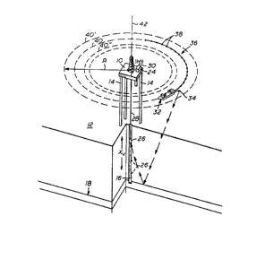
Figure l is a general illustration of a technique for
simultaneously shooting vertical seismic profile data as
well as surface seismic data:
Figure 2 is an areal view of a schematic representing
only one circular course steered by a vessel; and
Figure 3 is a schematic representation of the
subsurface coverage obtained by the inventive method.
In viewing the figures, like reference numerals
indicate like components. Figure 1 is a general
illustration of a technique for simultaneously shooting
vertical seismic profile (VSP) data as well as surface
seismic data. As typically used in offshore petroleum
exploration, a drilling or production platform 10 is
positioned above an area of interest of the sea floor 12.
The platform depicted in the figure rests directly upon the
sea floor 12 supported by a plurality of legs 14.
Alternatively, the platform may be a semi-submersible and
held on station by a plurality of anchors and cables. As
is well known, semi-submersible platforms are used in
regions having water depths greater than several hundred
feet. Located beneath the platform lO and penetrating the
subsurface o~ the earth is a borehole 16. For the purposes
of the discussion it will be assumed that the borehole is
substantially vertical and penetrates the subsurface to a
depth of -10,000 feet mean sea level through a target
horizon 18. ~he target horizon 18 may be a reservoir or
any other depth of interest to the geologist or production
engineer. For simplicity, horizon 18 is shown horizontal,
but in reality the beds may be dipping and contorted.
lZ~ 5
Located on the platform 10 may be a recording unit 24
operably interconnected to at least one borehole sensor 26
through a length of cable 28. The recording unit may
contain appropriate equipment to record signals sent from
the sensor in response to transient seismic signals.
Alternatively, the recording unit may contain a transceiver
coupled to an antenna 30 for transmitting the received
seismic data to a remote station located on a ship or
another platform. The length of cable 28 should be
sufficient to allow the borehole sensor to be lowered in
the borehole to a depth commensurate with the target
horizon 18. The borehole sensor 26 may also be allowed to
come to rest at any other depth Xv within the borehole.
Shown circling the platform 10 is a seismic vessel 32
towing a seismic source 34 usually submerged 20 to 35 feet
below the surface. Towed behind the seismic source 34 and
operably coupled to a recording unit inside the vessel 32
may be a streamer cable 36 which is neutrally buoyant and
positioned at a substantially constant depth of 15 feet.
The streamer cable may contain a plurality of detectors 38
disposed at known intervals along its length. Also
disposed at intervals along the cable may be compasses,
depth gauges and thermometers. For the purposes of this
description a detector may be defined as a single
hydrophone or a group of hydrophones coupled to provide a
single output. Up to as many as 1000 groups may be
contained in a streamer cable several kilometers long.
Alternatively cables as long as several hundred meters may
be employed. For the purposes of illustration only, a few
detectors 38 are identified along the length of the
streamer cable 36, however, it should be understood that
1~9;~5
--8--
many others are present.
Vessel 32 is shown steering a circular course 40
about an orbital focus 42 located substantially above the
borehole 18. The seismic source 34 and streamer cable 36
towed behind follow substantially the same course with
minor fluctuations caused by wind and ocean currents. The
radius of the circular course 40 from the orbital focus 42
is represented as R which varies inversely to the borehole
sensor depth ~v For example, if the borehole sensor 26 is
positioned at the maximum depth Xmax, the vessel 32 steers
a tight circular course having a short radius of Rmin. The
relationship between the borehole sensor depth Xv and the
radius of the circular course R is such that a
substantially constant angle of reflection is maintained
off the target horizon 18 from the seismic source 34 to the
borehole sensor 26. Although any angle of reflection will
suffice depending upon the desired results, however, it is
preferred that the angle of reflection be maintained
between 15 and 25 degrees from the normal to the target
horizon 18. For example, if the borehole penetrated the
target horizon at a depth of -10,000 feet and assuming that
the VSP survey will be conducted over the entire depth of
the borehole, and that a substantially constant reflection
angle of 25 degrees from the normal is preferred, the
maximum radius RmaX for VSP coverage is twice the depth
times the tangent of 25 degrees. Thus, according to this
expression, for a 10,000 foot borehole, radius RmaX for a
VSP survey is approximately 9,300 feet. For a
substantially constant 15 degree reflection angle off the
target horizon, the maximum radius RmaX would approximately
equal 5,300 feet from the orbital focus. Provided the
lZ~3~45
vessel could steer a circular course about the platform 10
at a radius Rmin equal to one-half RmaX without tangling
the streamer cable 36 with the platform, VSP coverage of
the borehole would be complete.
As briefly mentioned above, simultaneous with the
collection of VSP data, regular surface seismic data may
also be gathered. Figure 2 is an areal view of a schematic
representing only one circular course steered by vessel 32.
For the purpose of this figure, the vessel 32 and seismic
source location are assumed to be coincident. As mentioned
above, the radius of the circular course 40 is identified
as R. A mid-point 44 may be identified along a chord line
46 located between the source 34 and the last detector 38
located at the distal end of the streamer cable 36. As the
vessel steers the circular course 40, the mid-point 44 of
the chord line 46 tracks along an inner circle identified
as 48. A chord line such as 46 may be defined for each
detector 38 in the streamer cable 36. The mid-points of
the collective chord lines 46 define a locus of points
illustrated by line 50. The circular course tracked by
each mid-point differs slightly from each other because of
the circular course of the streamer cable, but all are
concentric with each other about the orbital focus 42.
From the above description, the areal coverage of the
surface seismic survey may be changed by altering the
radius of the circular course steered or by changing the
length of the streamer cable. The shorter the radius, or
the greater the cable length, the greater the distance
between the mid-point of the longest chord line 46 and the
streamer cable 36.
Using both of the techniques described above, VSP
1~93~5
--10--
data and surface seismic data may be collected
simultaneously. The simultaneous shooting of VSP and
surface seismic removes many of the problems present in the
prior art technique. That is to say that the number of
variables between the two data sets are reduced providing a
more accurate and clean correlation between the data sets.
Figure 3 provides a general explanation of how this is
accomplished through an areal view of the collection
geometry. Located at the center of the figure is the
orbital focus 42 located substantially directly above the
borehole 18 and the point about which the circular courses
are steered. The inner circle 52 enclosing the vertical
hatching is the subsurface area at the target depth covered
by VSP data. The outer circle 54 containing the horizontal
hatching is the area of the subsurface target sampled only
by surface seismic data. The annular region 56 between the
two circles containing the crosshatching is the area of the
target simultaneously sampled by both VSP and surface
seismic data sets. The data common between the two data
sets are used in later calibration and correlation known in
the industry to provide the resulting improved output.
The following is a description of a preferred mode
for simultaneously shooting both the VSP and surface
seismic data. Assume that the target depth is located at-
10,000 feet mean sea level and the borehole 16 penetrates
the target. Also assume that the léngth of the streamer
cable 36 is 1,800 feet and the desired range of reflection
angles is 10 degrees between 15 and 25 degrees from the
gravitational vertical. Using simple geometry, the
smallest circular course the vessel 32 can steer about the
orbital focus 42 has a radius Rmin of 2679 feet. This
1~3~5
radius provides a 15 degree reflection angle at the target
depth of the borehole 16. Assuming VSP coverage is to be
collected over the entire depth of the borehole, the
maximum radius RmaX for receiving the VSP signal near the
top of the borehole 16 is essentially 9,326 feet. This
radius provides a reflection angle equal to 25 degrees off
the target horizon 18. Thus VSP coverage of the target
horizon 18 extends from the base of the borehole 16
outwards to a radius of 4,663 feet. The surface seismic
coverage of the target horizon 18 begins at a radius of
2529 feet from the orbital focus 42 due to the feathering
effect of the streamer cable discussed above. The
feathering effect caused by the curvature of the streamer
cable is the line defined by the locus of mid-points of the
many chord lines 46 discussed earlier. Therefore, actual
surface seismic coverage is located inward of the vessel
radius by an amount equal to the offset of the mid-point of
the longest chord line. The region of surface seismic
coverage extends outwards from the borehole 18 as far as
desired to adequately cover the subsurface region of
interest. Using the constraints outlined above, the areal
coverage of simultaneous VSP and surface seismic coverage
is contained within the annulus defined by the radius 2529
feet and the greater radius of 4663 feet. It should be
apparent that as the radius of the circular course
increases, the areal swath of the surface seismic survey
decreases. For example, when the vessel 32 steams around
the orbital focus at a radius of 2679 feet, the swath
determined by the midpoint of the longest streamer cable
chord is 150 feet for a 1800 foot cable. At a radius of
4663 feet, the swath is reduced to about 87 feet for the
I
~3~45
-12-
same cable length. At a 10,000 foot radius, the swath is
reduced to 40 feet of coverage.
From the geometry discussed above, the same technique
may be employed in onshore seismic surveys. In such
onshore surveys, the seismic source is preferably
vibratory, however, other sources such as explosives may
also be used. Although in an offshore survey, the required
areal coverage of geophones may be logistically
impractical, grids may be positioned and appropriate sets
of geophones activated using a roll-along technique known
in the industry.
Once the desired survey area has been covered, using
either the offshore or onshore technique, both the VSP and
surface seismic data are inverted to provide acoustic
impedance. The great advantage to the inversion is the VSP
data may be calibrated with the surface seismic data from
the overlapping region of the survey. This inversion and
calibration provides better data correlation and aiding khe
interpretation process. It is apparent to those skilled in
the art that this technique removes many of the variables
which may have influenced earlier techniques of collecting
VSP and surface seismic data separately. It is also
apparent that this inventive technique reduces costs by
removing the need for two separate surveys.
The above description should be considered exemplary
and that of preferred embodiments only. Modifications of
the inventive method will become apparent to those who make
and use the invention. Such modifications may be
considered within the scope of the invention set forth and
limited only by the appended claims.