Note: Descriptions are shown in the official language in which they were submitted.
`` ~L2g37~7;~:
LANDING ASSISTANCE SYSTEM USING NAVIGATION SATELLITES
BACKGROUND OF THE INVENTION
l. Field of the Inventlon
The invention pertains to a landing assistance system
or aircraft.
2. Description of the Prlor Art
The most recent landing assistance system, which is a
standardized one, is a microwave landing sys~em called MLS.
It has two narrow microwave beams which do a vertical
scanning and a horizontal scanning, respectively, in the
direction of a landing strip. These two beams are used to
determine the position of an aircraft in a vertical plane
and a horizontal plane respectively. This MLS system is
currently installed or will be installed in all big
airports, but has the disadvantage of requiring complicated
infrastructure for each landing strip. This infrastructure
is, firstly, too expensive for small airports and,
secondly, too complicated to be set up quickly, for
tactical needs, at a military landing strip.
Furthermore, there are very precise known positioning
systems that use navigation satelli-tes, for example the
positioning system called NAVSTAR/GPS. A system of this
type comprises several satellites. Each satellite emits
signals controlled by an atomic clock and comprising,
notably, almanac data which make it possible to ascertain
~2~7~
the position of the satellite with respect to a geodesic
reference point. A positioning receiver, placed on board an
aircraft for example, is used to determine the position of
this aircraft by simultaneously receiving the signals
emitted by several satellites located in direct line of
view at a given moment. A constellation of eighteen
satellites is provided for, in order to ena~le reception
from four or five satellites at any instant at any point on
the earth. Each positioning receiver has a computing
device, used to compute the position of the aircraft in
three dimensions at high speed, using all the cumulated
phase data of the carrier emitted by each sate]lite and
using the phase of a code modulating this carrier.
A differential method described, for example, in
the French Journal NAVIGATION, No. 137, pages 88 to 91,
January 1987, makes it possible to improve the positioning
precision achieved through the GPS system. By this
differential method, the precision obtained is of about 3
meters on an average and makes it possible to envisage the
use of the GPS system as an aircraft landing assistance
system. According to this differential method, the system
comprises a fixed station which constitutes a reference for
aircraft located in the vicinity of the said fixed station,
within a radi.us of 100 kilometers for example. The Eixed
station has a receiver for positioning by satellite, which
;
~9~
gives an estimate of the position of this fixed station,
and computing means that give correction data representing
the deviation between this estimate and a reference
position, which may be the position of the fixed station
identified on a map. After eliminating the essential part
of the lag of the clock incorporated in the receiver of the
fixed station, the distances observed for each satellite,
called pseudo-distances, are compared with the exact
differences calculated from the almanac data transmitted by
the satellites and from the reference position. The result
of these computations give correction data, used to
compensate for most of the errors arising out of satellite
ephemerides and out of uncertainties in the propagation of
radio waves.
The fixed station further comprises radio transmission
means to transmit the correctian data to ai.rcraft. The
station on board each aircraft comprises, in addi-tion to
the receiver for positioning by satellite, radio reception
means to receive the correction data and computing means
for correcting, by means of the correction data, the
position est.imate given by the positioning receiver. This
computing device may be incorporated in the positioning
receiver, which is then called a differential positioning
receiver and directly gives the value of the corrected
estimate.
~2~79~
The corrected estimate is precise enouqh to be used to
guide a landing operation, but requires additional
reception equipment. ~owever, for reasons related to space
factor and cost, it is not desirable to increase the
quantity of equipment on aircraft so that they can use
another landing assistance system that complements the MLS
system.
SUMMARY OF THE INVENTION
The aim of the invention is to propose a landing
assistance system which can be used to replace the MLS
system for landing strips that cannot be provided with this
system , without considerably increasing the cost of
navigation and landing assistance equipment already used on
board the aircraft. The object of the invention is a system
essentially comprising, on board each aircraft, a
conventional receiver designed for MLS type landing
assistance and a conventional receiver of the GPS type for
positioning by satellite.
According to the invention, a landing assistance
system using navigation satellites comprises: several
navigation satellites emitting signals controlled by a
clock, a fixed station located in the vicinity of the
landi.ng strips and a station on board each aircraft, the
said fixed station comprising:
~ a receiver or positioning by satellite, the said
2~ 2
;
receiver giving an estimate of the position of the said
fixed station, and computing means giving correction data
representing the deviation bet~een this estimate and a
reference position;
- radio transmission means to transmit the correction
data, transmitting in a radio channel according to the
standards of the microwave landing system known as MLS;
and the said on-board station comprising:
- a conventional radio receiver to receive data
transmitted by a microwave landing system known as MLS;
- a receiver for positioning by satellite~ and
computing means that give an estimate of the position of
the aircraft, corrected by means of correction data
received by the radio receiver.
BRIEF DESCRIPTION OF T~E DRAWINGS
Figures 1 and 2 represent block diagrams of two
embodiments of the system according ko the invention.
DESCRIPTION OF TWO PREFERRED EMBODIMENTS
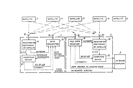
The embodiment shown in figure 1 comprises several
satellites o~ the GPS/NAVSTAR system, 3 to 7, a fixe~
station 1 constituting the reference station and a station
2 on board an aircraEt ~not shown). The fixed station 1
comprises: a receiver 11 ~or non-differential positioning
by satellite, a computing device 12 and a data transmitter
13.
~ '79'7~
The receiver 11 is a receiver for non-differential
positioning by GPS/NAVSTAR satellite. The sai~ receiver is,
for example, a TRIMBLE lOX receiver marketed by the TRIMBLE
firm. It is connected to an antenna 10 that can receive the
signals emitted by all satellites in direct line of view.
It has a first output, connected to an input of the
computing device 12, to give it an estimate X, Y, Z of the
geodesic coordinates of the position of the fixed station
1, calculated conventionally from -the signals received from
four satellites 3 to 6 from among all the satellites 3 to
7, which are in a direct line view at the instant
considered. This computation consists essentially in
determining the pseudo-distances between the fixed station
1 and these four satellites 3 to 6, and then in deducing
therefrom the geodesic coordinates of the fixed station
using the almanac data which are transmitted by these
satellites and which make it possible to ascertain, at any
instant, the position of the said satellites with reference
to the earth. The receiver 11 has a second output connected
to an input of the data transmitter 13 to yive it the
numbers of the satellites, the si~nals of which are used to
estimate the coordinates X, Y, Z.
The computing device 12 further has an input that
reaeives three refererlce coordinates which are constant.
It calculates the deviation between these reference
~9~
coordinates and the coordinates X, Y, Z and deduces
therefrom correction data marked ~X, ~ . It has an
output connected to an inpu~ of the transmitter 13 to give
it these correction data. The reference coordinates may be
either the exact geodesic position of the fixed station 1,
if it is known, or the position which has been determined
by the receiver 11 at a prior instant and has been
memorized once and for all.
The computing device 12 consists of a conventional
microprocessor base computing device. It also has the
function o~ giving a so-called integrity datum, indicating
that the signals of the satellites, used to determine the
coordinates X, Y, Z, are of adequate quality. The device 12
has an output connected to an input of the transmitter 13
to give it this integrity datum.
The data transmitter 13 has an input receiving a
sequence of data which is proper to the landing zone: for
example, the angle of the direction of a landing strip with
respect to the magnetic north, the coordinates of the
approach end of the strip and the identity of the strip.
The coordinates of the approach end of the strip,
transmitted by the transmitter 13, should relate to the
same reference point as the reference coordinates given to
the computing device 12 of the fixed station 1. The
coordinates transmitted are the geodesic coordinates of the
7917~
approach end of the strip in cases where the reference
coordinates are the geodesic coordinates of the fixed
station 1. The coordinates transmitted are coordinates
measured by using the system according to the invention, in
cases where the reference coordinates are coordinates that
have been measured by means o~ the receiver 11 of the
station 1 at a prior instant, and been memorized once and
for all. For this, an aircraft is placed at the approach
end of the strip and a series of position measurements is
done with an on-board station. The transmitter 13 has an
output connected to an omnidirectional antenna 1~ in the
horizontal plane. It transmits on a radio channel which is
usually dedicated to the transmission of ancillary data for
the MLS type landing assistance system. The transmitter 13
transmits, according to the standardized format for the MLS
system, the data consisting of the correction data ~X, ~Y,
~Z, the integrity datum, the satellite numhers and data
proper to the landing æone. The MLS channel frequency used
by the transmitter 13 is proper to the landing zone.
The on-board station 2 comprises: a data receiver 17,
a receiver 18 for non-differential positioning by satellite
and a computing device 19. The data receiver 17 is a
conventional receiver used in all aircraft ~itted with an
MLS type landing assistance system. The said receiver 17
is connected to an antenna 1~ which is omnidirectional in
q
the horizontal plane. It is matched by the aircraft pilot
to the MI.S channel frequency proper to the landing zone.
The receiver 17 has a first output connected to an input of
the receiver 18 to give it the numbers of the satellites
used by the fixed station 1 to estimate the coordinates X,
Y, Z. The receiver 17 also has a second output, connected
to an input of the computing device 19 to give it the
correction data ~ , and third output and a fourth
output, respectively connected to two inputs of an on-board
computer 8, placed in the aircraft considered, to give it
(namely the data receiver 17) the integrity datum and the
data proper to the landing zone.
The receiver 18 is connected to an antenna 20 enabling
it to receive all the satellites 3 to 7 which are in direct
line of view at the instant considered. The receiver 18 is
a conventional receiver for non-differential positioning by
GPS/NAVSTAR satellite. It has an output that gives an
estimate X', Y', Z' of the geodesic coordinates of the
aircraft at an input of the computing device 19. The
receiver la may consist of a TRI~BLE lOX receiver which is
lightly modifiecl because the numbers of the satellites
whose signals are used by the receiver 18 are not input
manually by an operator, but are given by the receiver 17.
This modification is not described because it is within the
scope of persons skilled in the art. An output of the
computing device 19 gives a corrected estimate of the
geodesic coordinates of the on-board station 2, computed
according to a conventional algorithm, using correction
data AX, ~y and ~ and estimate data X', Y', Z' given by
the receiver 18.
The on-board computer 8 hence receives highly precise
coordinates of the position of the aircraft and the
integrity datum which guarantees the validity of the
signals of the satellites used and that of the correction
data. It further receives the angle of the direction of
the strip with respect to the magnetic north, the
coordinates of the approach end of the strip and, if
necessary, any other data proper to the landing zone. The
computer 8 is a conventional on-board computer which
determines the landing guidance data. These data are given
to the human pilot by a landing indicator, or else they are
given to the automatic pilot.
The receivers for positioning by satellite
conventionally comprise a microprocessor-based computing
device. An alternative embodiment oE the system according
to the invention may lie in the use of the computing device
incorporated in the receiver 11 of the fixed station 1 to
constitute the computing device 12 through A modification
o~ the programming of the microprocessor which computes
positions in the receiver 11.
~2917972
Similarly, the computations done by the computing
device l9 of the on-board station 2 may be done by the
microprocessor, which computes positions in the receiver
18, through a modification of the programme of this
microprocessor. This same microprocessor may be used also
to perform some of guidance computations instead of the
on-board computer ~.
Figure 2 is a block diagram of a second embodiment of
the system according to the invention. This second
embodiment differs from the first embodiment in the type of
correction data transmitted from the fixed station 1
to the on-board station 2. In the fixed station l, the
receiver ll is replaced by a receiver ll' which is a
receiver for positioning by satellite. The said receiver
gives, in addition to the estimate of the three coordinates
X, ~, Z, an estimate o~ the pseudo-distances measured
between the fixed station 1 and all the satellites 3 to 7
respectively, which are in direct line of view of the fixed
station l at the instant considered.
In this example, the receiver 11' gives five
pseudo-distance values, dl,...d5, which respectively
correspond to the satellites 3 to 7. These values are
applied to an input o a computing device 12', similar to
the computing device 12 but working according to a slightly
dif~erent programme to determine the correction data
11
~IL29t7~7~
~dl,...~5, representing the deviation between the estimate
of the pseudo-distances dl,...d5 and the fixed reference
values which are computed by the computing device 12'. In
this second embodiment, the reference values consis-t of
true values of the pseudo-distances between the fixed
stakion 1 and the satellites 3 to 7, these true values being
computed, at a given instant, from the position of each
satellite and the position of the fixed station 1. ~s in
the first embodiment, the computing device 12' has an input
that receives three fixed reference coordinates. These
three coordinates are either the geodesic coordinates of
the station 1 or the coordinates were measured by
the receiver 11' at a prior instant and were memorized
once and for all.
The computing device 12' determines, like the
computing device 12, an integrity datum indicating good
reception of the signals emitted by the satellites and used
to determine the estimate of the pseudo-distances dl,...d5.
As in the first embodiment, the data transmitter 13
transmits on a channel according to the standards of the
MLS landing assistance system and according to a format
that complies with these standards. It transmtts the
correction data ~or all the satellites that are in direct
line o view, the integrity datum, the numbers of the
2S satellites corresponding to the correction data and data
~97~72
proper to the landing zone.
The on-board station 2 differs from that of the first
embodiment in the fact that the receiver 18 and the
computing means 19 consist of a receiver 18' for
differential positioning by satellite. A receiver of this
type has an input for correction data transmitted by a
fixed reference station. The receiver 18' receives
transmissions from all the satellites, 3 to 7, which are in
direct line of view, and selects four of them to make an
estimate of its position. It does not necessarily select
the same satelltes as those selected by the receiver 11' to
determine its position.
A conventional receiver for differential positioning
by GPS/NAVSTAR satellite, capable of correcting an estimate
of its position by means of correction data transmitted by
a fixed reference station, can be used practically without
modification. For example, the recei.ver 18' may comprise a
TR-5S type receiver marketed by the SERCEL (trademark)
firm.
This second embodiment requires a differential
positioning receiver i.n each on-board station 2, but has
the advantage of giving better positioniny precision Eor a
receiver since the correction is done directly on the
pseudo-distances o~ the satellites, before filtering and
estimatin~ the position, unlike the first embodiment where
~2~7~72
the correction is done after filtering and estimating the
position. Another advantage lies in the absence of
constraints in the choice of the four satellites used by
the receiver 18' to determine its position.
It is also possible to transmit additional correction
data in addition to corrections on pseudo-distances. This
additional correction data would consist of corrections on
the pseudo-speeds of the satellites with respect to the
fixed station 1, the true pseudo-speeds being computed by
the computing device 12 or 12' using almanac data from the
satellites. Known algorithms make it possible to use these
additional correction data to compute a corrected estimate
of the aircraft position with greater precision.
The invention is not restricted to the two embodiments
described above. Many types of receivers for differential
as well as non-differential positioning by satellite can be
used to make the system of the invention. In all cases, an
advantage of the on-board station is that it can be made
using an MLS receiver and a receiver for differential
positioning by satellite which are in standard use, or are
going to come into standard use on aircraft. The fixed
station does not require any complicated installation with
directional antenna. Thiæ means that it can be speedily
installed anywhere. It is therefore far less costly to
install than an MLS fixed station. Furthermore, one and the
14
~L297~72
same fixed station can be used for several neighbouring
strips, by transmitting distinct data packets for each
strip on the same MLS channel, unlike the case of the MLS
system where a separate fixed station is needed for each
strip.