Note: Descriptions are shown in the official language in which they were submitted.
- 2 -
REMOTE SENSING OF BITUMEN FROTH IN LAGOONS
CONTAINING TAR SANDS TAILINGS
This invention relates to a method of determining
the location and thickness of bitumen froth submerged in
the tailings lagoons of tar sands processing plants.
BACKGROUND OF THE INVENTION
In the processing of tar sands to extract bitumen
and process it further to petroleum products, very large
volumes of aqueous tailings are obtained which are
discharged to very large lagoons. These aqueous tailings
contain highly dispersed fine clay and silt particles and
also significant amounts of bitumen froth which were not
removed by the extraction process. Over time, the
tailings sludge matures, causing the bitumen in the
tailings discharged to the lagoon to coagulate to some
extent and form an irregular layer of varying thickness
suspended between the compressed higher density bottom
sludge and the lower density upper aqueous layer.
It is, of course, desirable to recover the bitumen
froth from the lagoon and if the location and thickness
of the suspended bitumen is known, an appropriate pump
can be used to remove it. The present invention enables
the location and thickness of the bitumen layer to be
rapidly determined and thus expedites the bitumen
recovery process.
DISCUSSION OF PRIOR ART
The present method of determining the location and
thickness of the bitumen layer is not entirely
satisfactory. In the present practice, a torque bar,
called a "T-bar", is manually used. This T-bar is a
long, graduated pole with a cross bar at one end and an
operator on a barge on the lagoon surface pushes the end
of the T-bar having the cross bar into the water and
twists the pole. As long as the T-bar is in the water,
l~9~-~
-- 3
little torque or resistance to twisting is observed, but
when it hits the submerged bitumen layer a strong
resistance to twisting is evident. When the pole is
pushed all the way through the bitumen layer the
resistance again becomes small. The operator can thus
plot the location of bitumen masses in the lagoon by
noting the depth of the T-bar when the resistance is
observed and also noting planar coordinates on a map of
the lagoon. To chart the lagoon for the submerged
bitumen by this technique requires much effort and time
and is not a satisfactory method.
It is known to measure concentration of hydrocarbons
which have seeped into a body of water. For example,
U.S. 3,747,405 discloses the use of a sampling device
suspended in a body of water and the sampled water is
pumped to an analyzing system to make measurements of the
areal location, distances above the bottom and
concentrations of the hydrocarbons from which data an
areal map of the hydrocarbon location is made. U.S.
3,710,615 discloses the measuring of oil in water which
occurs in small amounts from the discharge of oily water
from ships in navigatable waters and acoustic echoes are
employed for such measurement. No disclosure is known,
however, for use of an acoustic echo technique to
determine location and thickness of submerged bitumen in
an aqueous lagoon.
BRIEF DESCRIPTION OF THE INVENTION
In accord with this invention, submerged bitumen
froth layers in tailingl lagoons are sensed and their
thickness determined by aqueous or acoustic echo sounding
(sonar), using an operating frequency between about 5 and
about 12 kHz.
DESCRIPTION OF DRAWINGS
Figure 1 is a schematic representation of the sludge
in a tailings lagoon, showing a barge using the sonar
lZ9~ 3
technique for sensing the bitumen on the surface of the
water.
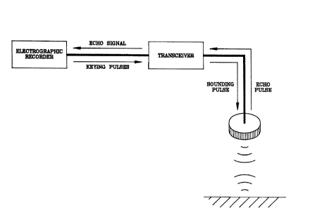
Figure 2 shows a schematic for a typical sonar
sounding system which may be used in the invention.
Fiqure 3 is a contour map plotted from the data
obtained by the method of the invention.
Figure 4 is a recorded sonar scan of a lagoon
containing bitumen.
DETAILED DESCRIPTION OF THE INVENTION
The method of the invention is based on the
observation that after tailings sludge has matured, the
density of the bitumen froth (ca. 1.01) is intermediate
between that of the recycle water (ca. 1.005) and that of
the compressed sludge (ca. 1.2 to 1.3), the latter being
composed mainly of water-silt-clay mixtures with small
amounts of bitumen and other hydrocarbons suspended in
it. As such, the bitumen froth layers, typically shown
in Figure 1, are suspended between water and sludge. In
the acoustic profiling system of the invention, sonic
pulses are transmitted vertically through the lagoon via
an appropriate energy source submerged in the water.
Boundaries across which acoustic material properties
differ partially reflect transmitted pulses. The energy
is then recorded and is displayed graphically to obtain a
visual record of the submerged bitumen (see Figure 2).
In carrying out the method of the invention, the
appropriate echo sounding apparatus is installed aboard a
barge adapted to move slowly across the surface of the
lagoon. The field procedure for the sonar survey is
based on the "dead reckoning" principle, and consists of
sailing the barge at constant engine power along parallel
lines, across the width of the pond. The sonar record of
each traverse is subsequently digitized at equidistant
intervals and stored as individual data files in an
appropriate computer system. Contour maps for top and
~"
129~3
-- 5 --
bottom of the bitumen sheet (i.e. the bitumen profiles)
are then constructed in a consistent manner by processing
this data through the general surveying programming
software. Isopach maps are then generated, and the
volumes contained between these surfaces are calculated
from the area and depth of the bitumen shown on the map.
In order to maintain consistent accuracy for the
process of the invention, it is very important that a
calibration procedure be used. This calibration
technique will use, preferably, the T-bar discussed above
to periodically determine the location and depth of the
bitumen layer and correlate the results of such
measurements with the acoustical data. The reason for
such calibration is that the equipment responses may
change with time, climate and mechanical aberrations, but
by calibrating the acoustic data with a few T-bar
measurements just prior to and/or during the process, a
very accurate result of the bitumen depth and location in
the lagoon is obtained.
The vertical scale for a seismic profile data
display is in units of two-way travel time, or the time
required for the transmitted pulses to travel to and from
the reflecting interface. For echo sounders used in this
invention, the only propagation medium for the sonic
waves is water, and hence, the measured wave travel time
can be directly expressed as a depth. Sonic velocity can
be adjusted for different sound speeds in waters of
different density and concentration of suspended
materials.
The acoustical pulse which is used in the method of
the invention will have a frequency of between about 5
and about 12 kHz. This range of frequency results from
the need to have a resolution in the tailings pond of at
least one foot and since the velocity of sound
propagation is about 4760 ft. per second, the minimum
, ~
1~983~P
-- 6 --
acoustic frequency required is approximately 5 kHz (i.e.,
4760 ft./sec. x 1 ft./cycle = 4760 Hz = 4.76 kHz).
Further, in order to employ a small-sized sounding
device, a compact piezoelectric transducer should be
employed.
The upper limit of the operating frequency is
determined by siqnal attenuation which increases quasi-
linearly with increasing frequency. Since the sound
waves in this application are propagated through
suspensions (recycle water and sludge) and a visco-
elastic emulsion (bitumen froth), attenuation can be
anticipated to be generally higher than usual. To
overcome the attenuation in the water, bitumen froth and
sludge in the lagoon, the frequency of the acoustic
signal need be no greater than about 12 kHz and use of
higher frequency would be a waste of energy. It is the
differential acoustic properties of the water, bitumen
froth and sludge layers that make it possible to obtain
acoustic profiles of the system. It is clear from the
above that, in view of the attenuation, acoustic signals
will not penetrate far into the bottom sludge. Further,
in addition to the contrasting sound velocity it is also
very probable that gas accumulates at the bottom of the
bitumen layer, hence providing an even better reflector
and thus enhancing accuracy of the method.
A typically useful acoustical device for the method
of the invention is a solid state sonar transceiver
(Model 248E), manufactured by Edo Western Corporation
supplied by Edo Canada, Ltd., Calgary, Alberta. This
device is a versatile, compact shipboard transceiver
featuring extremely low power consumption, reliable
solid-state operation and operates within the required
frequencies of about 5 to about 12 kHz. Further, it is
compatible with precision recorders and with a wide
variety of transducers. This transceiver is further
3393
-- 7 --
characterized by having the following specifications:
Pulse length = short 0.3 milliseconds
medium 5.0 milliseconds
long 10.0 milliseconds
Output impedance = 50, 100, 175, 250 Ohm
Power output = 2000 watt
Keying note = 1200 pulses per minute (generated by
recorder)
The transducer preferably used in the method of the
invention will use piezoelectric EC-69 lead titanate
zirconate having a resonant frequency of 12 kHz, an
impedance at 12 kHz of 200 ohms, a maximum input power of
2000 watt and a beam width of 33 at 12 kHz.
EXAMPLE OF THE INVENTION
Reference is made to Figure 3 which is a contour map
obtained by the invention. A barge on the northeast
water's edge of the lagoon (not shown) traverses across
the lagoon in an east to west direction using north
(vertical) and east (horizontal) coordinates from a
reference point to define the area of traverse. The
coordinates may be in any units of distance as
convenient, the units shown in Figure-3 being in feet
from the reference point. As the barge moves across the
lagoon the acoustic sensing apparatus on board as
described above is operated and at some point after
receiving the first few reflected signals (about 5 to
20), the apparatus is calibrated with a torque bar
determination of the location and depth of the bitumen
observed to be present. The barge then continues to make
soundings and recordings of the reflected pulses. After
completing the first crossing, the barge returns to the
other side without soundings and after locating itself
about 400 feet south of its starting place, again crosses
the lagoon while making and recording the soundings. In
this way, the entire lagoon is traversed and the results
''S~
~ ~,
-` 129~3
-- 8 --
obtained.
The data is obtained as a scan printout illustrated
by Figure 4. The bottom of the transducer is at 41 and
the top of the bitumen layer is at 42. The bottom of the
bitumen layer is shown at 43 which is also the top of the
sludge layer. The multiple echoes are shown as 44. The
thickness between 42 and 43 represents the thickness of
the bitumen layer. Thus, the distance measured in
millimeters of a vertical line between 42A and 43A
represents the thickness (e.g., the amount) of the
bitumen at this point. Furthermore, the position of each
such point represents a specific point on the lagoon and
by incrementally plotting these known points and
connecting points of equal value the isopach map is
obtained. The data obtained is plotted graphically to
obtain the isopach (contour map) of the bitumen layers in
the lagoon as can be seen from Figure 3. The isopach
lines show the depth in feet of the bitumen at the
locations defined by the north and east position points.
Where no isopach lines appear there is only water, no
bitumen being present. The amount of the bitumen at
locations between the isopach lines is readily estimated
by interpolation.
In view of the above it is clear that the method of
the invention enables bitumen reserves in a waste lagoon
to be calculated by determining from a moving barge
equipped with the appropriate acoustic instruments, the
thickness and aerial distribution (e.g., the location) of
such layered bitumen. In addition, movements in these
layers can be quickly, accurately, and inexpensively
monitored so that bitumen recovery facilities can be
properly located, and moved, if need be. A primary
advantage of this method is that it provides a continuous
read-out, compared to the discrete sampling previously
used, in addition to the high speed at which it can be
, .
lZ~8393
performed. With this technique, it is also possible to
monitor the change in geometric properties of these
layers, as they respond to the bitumen recovery
operation.