Note: Descriptions are shown in the official language in which they were submitted.
~ ~4lD~o'll ( h
131 1034
APPROACH TO HOVER CONTROL SYSTEM FOR HELICOPTERS
BACKGROUND OF THE INVENTION
1. E~leld of the Invention
The present invention relates generally to flight
control systems for helicopters and more specifically to
a system for controlling the approach of the helicopter
to a hover condition at instrument landing system and
microwave landing system facilities, without the
requirement of sophisticated and expensive low airspeed
sensors, Doppler radar, or precision position sensors.
2. Description of the Prior Art
In the area of fixed wing aircraft, low minimum
approach ~ully automatic and semi-automatic control
systems have been achieved by the peior art. However,
systems of this type are generally too costly and occupy
excessive space and weight to be practical for small and
medium size helicopters. They are required to be
fail-operational in nature, and the attendant redundancy
require-~ extreme sophistication and expense. Moreover,
such systems have been certified for low minimum
altitude operation only at Category II and Category III
ILS airport facilities. Such facilities exist at only a
relatively few major airports. Helicopters do not
typically fly into such major facilities, but rather
$~
.
:
131 103~
2--
operate from smaller general aviation type airports.
Thus, for a sys~em to be practical in the helicopter
market, it must be reasonably simple and economical as
well as be operational at Catagory I IL5 sites.
The key to suc~essful low altitude approach
maneuvers is the ability of the pilot to decelerate down
to very low airspeeds at the terminal end of an
approach. Flying at extremely low airspeeds (5-10
knots) results in a low descent rate, thereby providing
the pilot with sufficient time to assess his situation
and apply corrective measures if necessary i.e.,
continue the approach, take over with manual control,
initiate a go-around maneuver, etc.
The key to low speed helicopter operation is the
capability o~ measuring the aircraft speed down to
substantially zero values. The accuracy of conventional
pitot systems deteriorates rapidly at speeds below
appeoximately 60 knots. This is due in part because of
the helicopter rotor blade downwash effects which
introduce undesirable inputs into the airspeed measuring
system. Systems have been produced which employ mast
mounted sensors which can measure low air speeds
accurately, but these systems are susceptible to damage
a~d again are too expensive for the commercial
helicopter market. Doppler type radar based systems can
also mea6ure low speed accurately, but becau=e of their
1 3 1 ~
cost and siæe, have proven t:o be practical only in
military type helicopters.
Some previous systems have employed open loop
deceleration techniques which rely on longitudinal
accelerometer values only. These systems often compute
a desired descent path and speed to a predetermined
geographical location based on the initial measurements
when entering the glide path. Such calculations of
these descent paths will necessarilly require
assumptions about the winds that will be encountered
during the descent, since their exact nature is unknown.
It may be seen, therefore, that winds differing
significantly from the assumed values will cause the
aircraft to deviate from the desired path and thereby
result in either under or over flying the target
geographical location. Further, these systems may
result in terminal velocities which are unpredictable
when operating under adverse wind conditions.
In U.S. Patent ~4,551,804, invented by T. R. Clark
and C. D. Griffith, and assigned to the assignee of the
present invention, a constant deceleration is commanded
using a vertical gyro-referenced longitudinal
accelerometer as the feedback sensorr The actual
deceleration as a time function of the airspeed from the
initial airspeed to a second airspeed is measured~
Based on these measures, the total deceleration time to
131 1034
--4--
approach to a hover condition is predicted, after which
the commanded deceleration is removed. However, this
system is subject to inaccuracies, when operating under
adverse wind conditions.
The present invention provides improved performance
without requiring reliance on precision approach radar
or distance measurinq systems, and provides compensation
for departures from the glide slope. Only conventional
low-cost on-board sensors are used. The invention
computes helicopter airspeed during the terminal end of
an approach by making use of parameters already
available in a typical helicopter automatic flight
control system, sucb as vertical speed, glide slope
error, and longitudinal acceleration. These parameters
are blended together in such a manner as to provide a
measure of helicopter ground speed, which is then used
in a control law computation to decelerate the
helicopter to a near hover speed as the vehicle
approaches a predetermined altitude minimum. This
result~ in a helicopter positioned at a fixed altitude
(typically 50 feet) above the runway at a ground speed
near zero. In this situation, the pilot can take over
manually and land the aircraft or initiate a go-around
maneuver if visibility conditions are too poor ~o land.
Since the system is ground speed rather than
acceleration or airspeed based, its accuracy is not
.
131 1~34
5--
dependent on wind conditions.
The principles of the present invention are applied
to achieve the foregoing objective in a helicopter
having a pitch attitude con~rol system including rotor
cyclic pitch command means for controlling the pitch
attitude and rotor collective pitch command mean~ for
controlling the vertical lift thereof, means for
providing a signal representative of a vertical velocity
of the aircraft, means for providing a velocity error
signal representative of a vertical deviation of the
flight path of the aircraft from a predetermined flight
path, means for providing an algebraic difference of the
vertical velocity signal and the velocity error signal,
and function means proportional to a ratio of ground
speed and vertical velocity, responsive to the
subtracted signals, for deriving a signal proportional
to ground speed.
~ he ground speed signal is followed by a
complimentary filter for smoothing the ground speed
computation, thereby making it less susceptible to
inadvertant perturbations of a baro~etrically deri~ed
vertical speed signal, which can be caused by
atmospheric disturbances. The filtered qround speed
signal is combined with a ground speed reference signal
which varies as a function of the craft's radar
1 3 1 1 1~:~4
-6-
altitude, to provide a commanded fixed aircraft
deceleration rate. The resulting ground speed error
signal is applied to the pitch attitude control system
of the craft for controlling the pitch attitude.
~IEF 12EscRIpTIQ~l OF THE DRAWI~GS
Fig. 1 is a block diagram depicting in schematic
form a helicopter automatic flight control system.
Fig. 2 depicts the glide slope on a graph of
altitude versus range and illustrates the operational
modes of the collective and cyclic pitch mechanisms at
various ranges from the hover or landing terminal point.
Fig. 3 is a block diagram illustrating the
preferred embodiment of the invention.
DESCRIPTION ~F THE PREFERRED EMBODIMENT
Before proceeding to a description of the apparatus
embodying the inventive concept, reference will be made
to Figs. 1 and 2 for the purpose of discussing the
general operational features and requirements of the
invention. A diagram of a typical helicopter automatic
flight control system is shown in Figure 1. A flight
guidance computer 10 serves as the computational part of
the system. It may include several axes of computation,
including a pi~ch axis 12, roll axis 14, collective axis
16, and a yaw axis 18. The computer may be analog or
digital in nature with most present day systems
including both analog and digital technologies. Pitch
1 31 1 034
7_
and roll ~ttitudes are controlled by means o~ the cyclic
pitch control of the primary rotor system: yaw is
controlled by an anti-torque tail rotor; and altitude is
controlled by the collective pitch control of the
primary rotor system. In addition, cyclic pitch also
controls the ~ore and aft motio~ or airspeed of the
helicopter and the lateral motion thereof.
The flight path of the helicopter is controlled in
accordance with a plurality of signals derived from
craft attitude and position references carried by the
craft, these signals being combined and correlated as a
function of the dynamic flight characteristics of the
helicopter. Each axis 12, 14, 16, and 18 receives
signals from respective sensors 30, 32, 34, and 36 for
stabilizing the associated axis. Thus, roll
stabilization of the aircraft may be achieved by
providing a roll displacement control signal from a
vertical gyro and a rate of change signal from a rate
circuit. The resultant signal is supplied to suitable
amplifiers and shaping networks and to the computer 14,
the output of which energizes the roll actuation system
24. Stabilization about a selected altitude is obtained
by providing a displacement signal corresponding to
deviations ~rom a preselected altitude which, together
with a rate of change signal supplied by a suitable rate
circuit, is applied to the collective axis actuation
t 3 t 1 ~34
--8--
system. For stabilization about the yaw axis a
gyromagnetic compass and heading selecter provides an
output siqnal corresponding to deviations in the heading
of the craft from a selected heading. This signal,
together with a signal proportional to the yaw rate and
lateral acceleration of the aircraft are applied through
suitable ampli~iers to the yaw actuation system and tail
rotor controls 26. The pitch axis portion 12 of the
computer (which is primarily addressed by the present
invention) takes input signals from various aircraft
~ensors 30 such as airspeed, altitude, and longitudinal
acceleration and performs outer loop control law
computations in block 42 which result in a pitch
attitude reference 38. The outer loop refers to the
function of controlling the path of the aircraft by
introducing attitude and headiny inputs to the
autopilot. The pitch attitude reference signal 38 is
applied to the pitch attitude control law system 40,
which amplifies and shapes the reference signal and
stabilizes the helicopter at a desired pitch attitude by
positioning the longitudinal cyclic actuation syste~ 20.
The longitudinal cyclic actuation system is mechanically
coupled to the helicopter rotor system swash plate 22.
The r~ll axis 14, collective axis 16, and yaw axis
18 sections of the system perform in a similar manner.
Various input signals are combined in a manner such as
- 9 -
to control the vehicle flight path as desired by
controlling the various roll, yaw and collective
actuators 24. The roll and collective actuators are
mechanically coupled to the main rotor swash plate 22,
while the yaw actuators are mechanically connected to
the tail rotor pitch controls 26.
Land based civil aircraft rely on the instrument
landing system (ILS), which is a low altitude approach
system that does not provide guidance signals all the
way to touchdown. The International Civil Aviation
Organization (ICAO) has defined three categories for
landing civil aircraft aided by ILS. Category I has a
200-ft ceiling and runway visual range of 2400 ft. The
visibility must exceed 2400 ft. for the pilot to attempt
a landing. Category II provides for a 100 ft. decision
height and 1200 ft. runway visual range. Category III
is subdivided into three ranges, from zero visibility to
700 ft. runway visual range.
Most commercially available helicopter systems are
limited to instrument flight rules (I~R) operation above
200 ft. of radar altitude at Category I airport
facilities. In part, this is due to the reaction time
required for the pilot to apply corrective measures in
the event a safe approach cannot be continued due to
system malfunction, poor visibility, unexpected wind
shear, etc. By reducing the speed of the helicopter to
~ 31 1 034
~lo--
a very low value near the terminal end of the approach,
the craft will approach the yround at a low descent
rate, thereby increasing the time available to the pilot
to assess his situation. This added available reaction
time may allow reduction in certifiable visibility
minimums.
As shown in Fig. 2, from approximately 1500 ft. to
approximately 100 ft. above the runway, the approach is
guided by a radio beam 50, defining a glide slope path.
The elevation of the glide path i8 typically 2.75.
Deviations of more than a few tenths of a degree from
this nominal value are unusual. Prior to encountering
the glide slope beam, the vertical (collective pitch)
axis of the craft may typically be operated in an
altitude hold mode to fly at a constant altitude 52
while the longitudinal axis tcyclic pitch) of the craft
is operated in a constant speed mode in accordance with
a speed selected by the pilot. Typically, the
helicopter approaches the transmitted glide slope beam
at an angle and at an airspeed consistant with normal
airport traffic and as directed by the ground controller
(typically 90 150kts). ~t point 54, a gradual descent
is initiated which causes the aircraft to asymptotically
capture the glide slope bearn 50. Upon capturing the
glide slope beam, the altitude hold mode is disabled in
the vertical channel, which thereafter is controlled by
131 1034
--11--
a glide slope displacement signal. The constant speed
control of the longitudinal axis is maintained until the
craft reaches a predetermined range point 56 from the
terminal point. At point 56 a deceleration program
commences which decelerates the aircraft to a very slow
speed (5-lOkts). During the deceleration program, the
longitudinal axis is controlled by an error signal
indica~ive of the difference between a computed ground
speed and a varying ground speed reference. At point 58
a flare maneuver is executed to level the aircraft at a
predetermined altitude ~typically 50 ft.3 above the
runway. A longitudinal axis reference signal is
provided so as to keep the aircraft acceleration at a
value near zero, thereby preserving the terminal
velocity condition which exists at the time of flare
mode initiation.
The invention is primarily directed at that portion
of the approach where the deceleration occurs. As noted
above, the beam angle ~< of a typical glide slope
transmission is typically 2.75. Therefore, a simple
geometric relationship permits a reasonable prediction
of vertical velocity as a function of ground speed:
h = Vg tan~ (1)
1 3 1 1 034
-12-
where,
h = vertical velocity.
Vg = ground speed.
o~= glide slope anyle.
Minor changes in vertical velocity can be expected
should the aircraft deviate from the predetermined ylide
path. These deviations can result in serious errors in
the computed ground speed unless compensated. The
variations, however, are predictible and are a function
of the glide slope error ~e~ glide slope control law
gain ~Kl), and the dynamics of the collective axis
vertical velocity closure, whose response may be
represented by a lag network having a time constant ~1
While glide slope error is conventionally measured
in degrees of deviation from the center of the glide
slope beam, it is readily converted to a linear measure
by conventional trigonometric computation since the
actual altitude is known from the radar altimeter and a
slant range d may be computed from the known glide slope
angle. Using the well known approximations for
trigonometric functions of small angles, since the glide
slope deviation is typically of the order of 0.5 degree
or less, results in the following equation:
~ h = d sino< e t2)
131 ~034
-13-
Thus from equation (1)
h = Vg tanoJ~ ~ Kl ~ h/( ~.1 S + 1~ (3)
where ~ h is an altitude error proportional to glide
slope error. Solving for ground speed,
Vg = [h - Kl ~h/(~l S + l)]/tan ~ (4)
where ~l may range between 0.75 to 2 sec, and typically
has a value of 1 sec, and Kl typically has a value of
0.2 feet/sec/ft.
The present invention may be implemented by using
conventional analog circuitry and computational
techniques or by using conventional wholly digital
techniques or by using conventional hybrid
digital/analog techniques. To simplify the
understanding of the invention, it will be explained by
using a generally analog format as shown in Fig. 3, it
being understood that the same analog format may also
represent, in block diagram form, the program of a
programmable digital computer wherein the various analog
inputs are converted to digital signals for digital
processing and the various digital outputs are converted
to analog signals for driving the control servo motors
and the like.
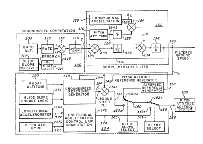
Fig. 3 illust~ates an embodiment of the present
invention for generating a signal accurately
1 31 1 034
--lg--
proportional to ground speed and thus may it be employed
as a data source for generating an error signal for
drivi~g the pitch attitude control system in the various
operational modes of the flight path. The
implementation is based on deriving redundant measures
of the ground speed term; the computation of block 100
is based on air data; the computation of block 102 is
based on inertial elements. ~he two measures are
processed by frequency responsive networks in a manner
to eliminate undesirable frequency characteristics and
yet retain smoothness, accuracy, and excellent dynamic
response. The mathematical development for the
computation of filtered ground speed ~9 is summarized in
the following relationship:
~9 = x/(r2 S + 1) + x ~2/(r2 S + 1) (5)
In equation (5) x represents the ground speed
computation of block 100 on line 120 derived from
barometric altitude 108. ~2 is the time constant of a
low pass filter having a transfer function ~ 2 S + 1),
where S is the time differential operator d/dt. The
time constant ~2 is of the order of 4 seconds which is
long enough to filter out the anomalies of the air data
static source. The term x represents the longitudinal
acceleration of the craft, corrected for gravitational
errors in a m ~ner to be described. The term
131 103~
-15-
~2/(r2 S + 1) represents an electronic washout circuit
wherein the time constant is chosen to be long enough to
filter anomolies in the barometric altimeter output of
the aircraft due to pitch rates, wind gusts, wind sheer,
etc., but short enough as not to be affected by the long
term effects of the erection characteristics of the
vertical gyroscope used for deriving the pitch attitude
signal.
Block 100 shows a circuit for deriving the ground
speed computation of the present invention in accordance
with equation (4). A signal representative of altitude
is provided by barometric altimeter 108 and applied to
rate generator 110 to derive a signal corresponding to
the vertical velocity h of the aircraft. Conventional
glide slope receiver 112 provides an error signal ~
representative of the departure of the aircraft from the
glide path. The error signal ~ h is applied to a high
pass filter 114 having a time constant ~2 corresponding
to the dynamic response of the collective axis vertical
velocity closure. ~iltered glide slope error is applied
on line 115 to a summing junction 116 where it is
subtracted from the vertical velocity factor h~ The
output of summing junction 116 is then applied to
function block 118, where it is multiplied by a
trigonometric function corresponding to the inverse of
tangent ~ , the angle of the glide slope. The output of
131 1034
-16-
block 100 on line 120, therefore, represents the
computed ground speed, corrected for departures from the
glide slope path.
Referring now to block 102, the elements of a
complementary filter are illustrated along with the
derived inertial acceleration signal. A longitudinal
accelerometer 168 strapped to the longitudinal axis x of
the aircraft can be used to measure acceleration. ~he
output of a linear accelerometer strapped to the x axis
contains spurious signals because it is affected by the
gravitational field of the earth. The accelerometer
cannot differentiate between the equivalent acceleration
of the earth's gravitational field g and the
acceleration component x of the aircraft. The effects
can be compensated, however, because the value of g is
accurately known, as is its direction. It is well known
by those skilled in the art that the signal output of
the accelerometer may be represented by the following
equation:
Ax = x + g sin~ (6)
where
Ax is the signal output of the longitudinal
accelerometer
x is the longitudinal acceleration of the aircraft
g is the acceleration due to the earth's
131 1034
gravitational field
~ i8 the angular disposition of the x axis of the
aircraft with respect to ground.
Tbus, the desired longitudinal accelera~ion
component may be derived by subtracting the component
due to the earth's gravitational field, which along the
flight path is g sin ~ . The signal output 122 of the
longitudinal accelerometer 168 is applied to one input
of a summing junction 124. A pitch axis gyro 170
provides a pitch attitude signal 126 which has a value
of sin ~. The pitch attitude signal is applied to block
128, which has a gain factor of g resulting in the term
g sin ~. This signal is subtracted from the
longitudinal acceleration signal Ax at summing junction
124 to provide the resultant craft acceleration x. The
term x is based on the assumption that for small angles
the value of the horizontal acceleration component is
very nearly e~ual to the longitudinal acceleration
component.
The computed ground speed signal 120 derived from
barometric altitude is applied to summing junction 130.
The output of summing junction 130 is multiplied by gain
132 which has a value of 1/r2. The gain scaled output
thereof is applied to a further summing junction 134
where it is combined with the longitudinal acceleration
x. The output of summing junction 134 is applied to an
131 1034
integrator 136 and the output thereof returned on line
138 inclosed-loop fashion where it is subtracted from
the barometric altitude signal 120 at summing junction
130. The action of the filter loop may be represented
by the following equation-
~(x - Vg)/~2 + x]/S = Vg. (7)
It may be seen that if the value for filtered ground
speed Vg derived in equation (5) is substituted in
equation (7), then the magnitude of filtered ground
speed will be seen to be equal to the magnitude of the
barometrically derived ground speed.
Referring now to block 104 of Fig. 3, a glide slope
control sequence involves interception of the glide
slope beam at a safe altitude and airspeed, detection of
the beam and capture when the aircraft has crossed the
null of the beam, tracking of the aircraft on the glide
slope beam, programmed deceleration of the aircraft to a
lesser speed and, further deceleration to hover when the
aircraft descends below a predetermined decision height.
An automatically sequenced glide slope mode would
normally start with the flight guidance computer
operating in the altitude hold mode. During this
period, a reference airspeed error signal senerated in a
conventional manner in block lS8 is applied through
contact 16Oa of switch 160 and contact 162a of switch
~31 103~
162 on line 166 to the pitch attitude control system
106. The output of generator 158 represents airspeed
error relative to the desired airspeed. The airspeed
may be selected by the pilot or programmed externally
during the approach and landing phase. The error signal
will drive the pitch attitude control servos until the
desired airspeed has been achieved, in a conventional
closed loop fashion. Upon capturing the glide slope
beam, ground speed reference generator 148 is engaged by
glide slope engage logic 152 to provide a ground speed
reference error signal in 154 accordance with a
predetermined deceleration program. One such suitable
program which provides both constant deceleration and
variable deceleration as a function of time is shown in
U.S. Patent 3,916,688, issued November 4, 1975 to J. C.
Dendy, et al., and assigned to the assignee of the
present invention. The ground speed reference generator
receives signals representative of radar altitude and
the filtered ground speed and when enabled by the glide
slope logic 152 produces a ground speed reference signal
on line 154 which is applied to summing junction 146 and
combined with signal Vg from node 144. The output of
summing ~unction 146 i8 applied on line 156 to switch
160. Within 5 to 10 seconds after glide slope capture,
when the altitude of the craft is within a predetermined
error with respect to the glide slope path, glide slope
1 3 1 1 034
-20-
select logic 162 is enabled by the fli~ht director
compute~ and transfers the contact arm of switch 160 to
contact 160b. This enables the signal of the ground
speed error signal derived in summing junction 146 to be
transmitted through switches 160 and 162 to the pitch
attitude control system 106. Since the actual flight
path angle is now substantially equal to the glide path
angle, the aircraft will be decelerated and descend on
the ylide slope inclination until a decision height is
attained, determined in a conventional manner by the
radar altitude sensor 150. Initiation of the flare path
is sensed by determining the instant at which the
aircraft's actual altitude as determined by the radar
altimeter is less than the ~lare initiation altitude.
This is done by flare select block 164 which then causes
switch 162 to switch the contact arm to contact 162b
thereby switching the system from its glide slope
command to the flare-out command. Longitudinal
acceleration control law block 172 processes
longitudinal acceleration from accelerometer 168 and
pitch attitude from gyro 170 and is configured so as to
keep the aircraft acceleration at a value near zero,
thereby preserving the terminal velocity condition which
exists at the time of flare mode initiation. The flare
maneuver will bring the aircraft to a stabilized
altitude (typically 50 ft.) above the runway.
1 3t 1 034
-2~-
From the foregoing, it will be appreciated that the
present invention provides an improved low speed
approach system in the following manner:
(1) ~ircraft deceleration is controlled by a
measure of ground speed which is independent of ground
based distance measuring systems and reliable under
adverse wind conditions.
(2) The ground speed computation is corrected for
glide slope error where the aircraft deviates from the
glide path.
t3) Only sensors and parameters available on
typical helicopter automatic flight control systems are
eequired.
While the invention has been described in its
preferred embodiment, it is to be understood that the
words which have been used are words of description
rather than of limitation, and that changes or
alterations may be made without departing from the true
scope and spirit of the invention in its broader
aspects.