Note: Descriptions are shown in the official language in which they were submitted.
-- 13~7822
2 21766-540
The invention relates to a method for producing a map of
a region of the type consisting of an elongate strip of zig-zag
folded sheet material, whereby each sheet section is a margin
wider between two successive folds than the preceding sheet
section and whereby in each case at least on each pair of pages
lying against each other in the folded state a map is printed and
on the margin thereof not covered by the preceding sections
reference symbols are printed.
A map produced according to such a method is known from
NL-A-8303809 and has evolved from earlier known motoring maps
which are zig-zag folded, as a result of which they can be
partially unfolded and are easier to handle in the restricted
space of an automobile.
A map of the type described in the preamble opens like a
book, whereby the table of contents is shown on the front flap and
using reference symbols arranged on the margins refers to pages
having a particular map sector.
The above mentioned earlier zig-zag folded motoring maps
are formed by a full map of the relevant region which is made
easier to handle only by the zig-zag folding. A map produced
according to the current method comprises on the other hand a
number of separate maps of sub-regions. These can however thereby
be ordered such that sheets showing contiguous sub-regions are
arranged on following pages of the folded map.
The choice of the division of the region into a number
of sub-regions, and the subsequent distrlbution of these sub-
regions, over the available pages of the map determines to a very
large extent the utility of the map. It has been found that maps
~ . :: ~..... ,
~3278~2
3 21766-5~0
produced according to the current method that are obtainable on
the market have a more or less chance construction which by no
means always ensures optimum utility. It is assumed that this is
i the result of the large number of variables that play a part in
jl the construction of the map. In the usual trial and error method
by no means all the values resulting in optimum utility are found
for all variables.
~ The purpose of the invention is to provide a method of
j the type under consideration with which maps can be produced of
;f lO optimum utility.
The invention provides method or producing a map of a
region of the type consisting of an elongate strip of zig-zag
folded sheet material, whereby each sheet section is a margin
wider between two successive folds than the preceding sheet
section and whereby in each case at least on each pair of pages
lying against each other in the folded state a map is printed and
on the margin thereof not covered by the preceding sections
; reference symbols are printed, said method comprising the steps
~ of: choosing the dimensions of said strip of sheet material and
f 20 the number of zig-zag folds, starting from a map to scale,
dividing of the region into a number of sub-regions corresponding
to the number of pairs of pages available, allocating a map of a
sub-region to each pair of pages, composing a film of maps of all
sub-regions and the margins in accordance with the position of the
pages on said strip of-sheet material for the purpose of
manufacturing printing plates, manufacturing printing plates,
printing said sheet material on both sides, cutting said strip out
; of the printed sheet material, and zig-zag folding said strip,
':: .'' ~ i ~ : : ' . ' .
13278~2
3a 21766-5~0
charac-terized in that the step of dividing the region into a
number of sub-regions comprises: successively dividing the map to
scale into different numbers of mutually equally wide strips, this
for each division such that a minimum surface area of contiguous
region is covered, and for each strip division, determining the
minimum length of each strip such that each strip comprises just
the corresponding portion of the region on the map, and
determining the ratio of -the sum of the lengths of all the strips
to the strip width, choosing the strip division whereby this ratio
is minimally smaller than the ratio of the sum of the lengths of
all the available pages in transverse direction of the folds, to
the height thereof, selecting as much as possible groups of
adjoining pages, each group having proportionally at least a total
length corresponding with the length of a strip of said strip
division, whereby each part of the associated strip corresponding
with a pair of pages of a group relates to the sub-region to be
allocated to that pair of pages.
As a result the optimal strip division is first found,
whereby, taking into account the chosen points of departure, the
largest possible scale for the map is obtained. As a result of
the approach of reproducing the region on the map in the form of
strips and as a result of making the relationship between
adjoining strips entirely secondary, a distribution of the sub-
regions over the pages of the map is achieved of optimum utility.
Giving no consideration or only secondary consideration to the
relationship between adjoining strips is not a drawback for the
use of the map since in going from a sub-region from one strip to
a sub-region in an adjoining strip another set of pages has in any
.
1327~2
3b 21766-540
case always to be turned over. Using the table of contents on the
front page the relevant set of pages can be localized quickly and
it is of no importance if this set is to be found on set of pages
not located nearby.
When a series of maps of different regions is produced
with the method according to the invention a systematic
arrangement is achieved as a result. Preferably the first pages
of the folded map will contain the sub-regions most frequently
consulted.
With the method according to the invention sufficient
map space will generally already be available to form an overlap
between contiguous sub-regions of one strip. An overlap can
likewise be formed between successive sub-regions of adjoining
strips. It is possible to show the regions of importance on as
large a scale as possible.
It is noted that as a result of -the method the usual
;:
.
, ,
:
: . .~ : : :
: : .. . ~ .. . : . ::
., ~ .
13278~2
--4--
~ cartographic scope is not limited. Island groups or outjut-
! ting portions of the region for exarnple can thus be shown in
the usual manner on an inset map.
The invention will be further elucidated in the
S following description with reference to the annexed figure~.
'f Fig. l shows in perspective view a map produced with
l the method according to the invention.
''f Fig. 2 and 3 show the manner in which the map obtain-
'5~ ed with the method according to the invention is used~
10 Fig. 4 shows front and rear views of a strip of
sheet material used as point of departure for a map to be
f ~ ~ produced, the ~olds to be arranged being shown therein.
''f`~-~' Fig. ~-7 show respectively three possible strip
f~ divisions for a region to be shown on a map.
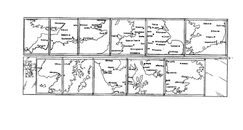
15Fig. 8 shows a front and rear view of a map produced
with the method according to the invention.
Fig. 9 shows views similar to fig. 8 of a map obtain-
ed according to the invention having a different arrangment.
Fig. l0 is a map to scale having an arrangement into
subregions obtained with the method as applied in the map
from fig. 9.
The map l shown in fig. l consists of an elongate
strip of sheet material folded up in a series of zig-zag
folds ~. Each sheet section between two successive folds is
~ ,:
1 25 a margin 3 wider than the previous section. This margin con-
' sequently protrudes outside the preceding sheet sections and
f, remains visible in the folded state of the map l that is
shown. Printed on each margin 3 are reference symbols 4
which may take the forM of numbers and/or different colours.
On each pair of pages that lie against each other in the fol~
ded position is printed a sub-region corre3ponding to a port-
ion of the total region shown by the map. Printed on the
front flap 6 o map l is a key map 5 of the whole region
shown by the map, whereby the division into sub-regions is
~1 35 indlcated on this map. The corresponding reference symbols
are also to be found on key map 5 so that the map of the
relevant subregion can be found simply.
The map is printed on both sidecf and may be folded
' . ~
~327~22
--5--
out to the left as shown in fig. 2 so that the sheets print-
ed on the front side become visible.
Shown in fig. 2 are three pairs 8, 9, 10 of pages
which in the folded postition lie against one another and
which have the margin 3 arranged on their edge.
Fig. 3 shows in similar manner three pairs o~ pages
11, 12, 13 which contain maps printed on the back of the
sheet material. It may of course be sufficient in use of the
map 1 to fold open the pair of pages showing the sub-region
to be referred to. Map 1 is thereby handled as a book that
can he unfolded both to the left and the right. As shown in
fig. 2 and 3 however, a number of adjoining sheets can also
be viewed at one time. It ~ay be useful in acquiring an over-
view if adjoining maps shown contiguous sub-regions.
Shown in the top half of fig. 4 is the front of the
strip sheet material, while in the bottom half of fig. 4 the
rear side is shown in turned over position. The fold lines
where forward facing folds have to be arranged are indicated
in full lines and the fold lines where rearward facing folds
have to be arranged are indicated with dash and dot lines.
It will be apparent that a forward facing fold on the front
si~e corresponds with a rearward facing fold on the rear
side. The coacting pairs of pages, which must each contain
a map of a subregion, lie between two full fold lines or
between their end edge and a full fold line. A9 observed ear-
lier the front flap 6 is used to show the table of contents
5. The rear flap 14, which in the chosen example with eleven
folds is located on the rear side of the sheet material, may
also contain a sub-region of the map, but is preferably used
for showing the legend and a slightly detailed outline map
of the relevant region. The total surface area of the map
available for showing the relevant reqion is thu~ determined
in this embodiment by the total surface area of the pairs of
pages designated with the reference marks 1-11 inclusive.
; 35 By way of explanation the method will now be des-
cribed as it is employed for the production of a map of
Great Britain and Ireland, starting from a strip of sheet
material as shown in fig. 4.
. . ~, . .: . ~ ~, . :
:, , :. :.~ : , : ., ...:
:~ . :
6- 1 327822
.
Point of departure is a map to scale of the region
concerned as shown in the figures 5-7. The scale map is di-
vided into a number of equally wide strips. The map in fig.
is divided into three ætrips 16 each having a width
5 corresponding to a third of the maximum north-soutn measure-
ment. Each strip has a length such that a minimum surface
area of contiguous region is covered.
Fig. 6 and 7 show strip divisions whereby each strip
has a width corresponding to a quarter and a fifth respec-
lO tively of the maximum north-south measurement. Each strip is
aqain chosen such that a mini~um surface area of contiguous
region is covered. With the division of fig. 6 six strips 17
result, while in fig, 7 eight strips 18 are obtained.
As i~ clear from khe figures, the a3sumption that a
15 minimum surface area of contiguous region i9 covered can
result in parts which can be considered as more or less se-
j parate being divided into separate strips, as is shown for
Ireland and Ulster in fig. 6 and 7. A certain overlap may
` thereby occur between stPips in their lengthwise direction.
At this stage the usual cartograhpic operations can
be carried out for the purpose of achieving maxi~um uti-
lization of the surface area. As indicated at 19 in fig. 7
it can be anticipate~ at this stage than an island of island
; group can be shown on an inset map. Performing of this
25 operation likewise results in limitation of the contiguous
region that is covered.
Subsequently, for each strip division, that is, for
each of the figures 5, 6 and 7, the length of each strip is
determined such that each strip comprises precisely the rele-
3G vant portion of the region on the map. These lengths aredrawn in the figures 5-7. Known cartographic operations can
also be hereby performed. Thus for example, as is shown at
20 in fig. 6, a particular portion of the region that is un-
important for the intended purpose of the map, in the cur-
35 rent case as motoring map, can be omitted or also shown inan inset map.
For each strip division the ratio of the total
length of all the stripæ to the strip width is then deter-
~L3~7~2
--7--
mined. It is simple to work out that for the strip division
of fig. 5 this ratio amounts to 5.9, for the strip division
of fig. 6 to 9.~, and for the strip division of fig. 7 it is
14.5.
5With reference to fig. ~ it can be determined that
the ratio of the total lenght of all the available pages in
the transverse direction of the folds, that is, in the
direction from left to right in fig. 4, to the height there-
of is 10Ø
10In accordance with the method according to the in~
vention the strip division selected as being suitable is
that whereby the said ratio is minimally smaller, that is,
the closest to and still smaller than the said ratio lOØ
This is therefore the strip division of fig. 6, whereby the
ratio of the total length of all the strips to the strip
width amounts, as noted earlier, to 9.4.
' By selecting the strip division whereby the lenght-
width ratio is just smaller than the length-width ratio of
the available surface area on the map, the largest possible
scale is on the one hand obtained for the final map, while
on the other hand slightly more material is available in
lengthwise direction of the sheet material for the map than
corresponds with the total length of the strips. This extra
space could be utilized for dividing the strips into the
separate sub-regions and perhaps also for forming an overlap
between sheets showing contiguous subregions.
Preferably at this stage in accordance ~ith the in~
vention the scale of the map for printing is calculated from
the scale of the scale used as a starting point, as shown in
the figures 5-7, by multiplying this scale by the quotient
of the height of the sheet material and the strip width,
that is, the measurement of a strip 17 in fig. 6 taken in
the direction from top to bottom. When it desired to provide
the maps with an overlap in transverse direction of the
strips, that is, in the example on the top and bottom edges
of the maps, the scale obtained in this way is reduced by a
percentage corresponding to the desired overlap. The scale
obtained is then reduced to a proximate map scale of round
.. : - , . . .
. ,:, . : ~ : .
~3~7~2
--8--
figure value, which normally amounts to a small whole number
ti~es a whole power of ten.
For the following phase of the method the strip di-
vision on the map is adjusted to scale to the determined
5 scale of the map to be printed. That is, the width of each
strip 17 and in fig. 6 is taken such that it corresponds
with the north-south dimension of the sub-regions to be
shown on the map. A limited rearrange~ent of the strips may
hereby be carried out.
As a result of adjusting the map scale in the manner
discribed according to the invention the extra available
space in lengthwise direction of the map will also have in-
creased relative to the required length corresponding to the
total length of the strips. The possibilities for a suitable
15 division into subregions have as a result been increased
such as to result generally in a reasonable freedom of
choice.
In the following stage of the method according to
the invention a maximum number of groups of adjoining pages
20 are selected whereby each group has a total length correspon-
ding proportionally at least to the length of a strip if the
chosen strip division. This has the consequence that sub-
regions that are contiguous in the strip direction are shown
as well as possible on adjoining pairs of pages. As a result
25 of unfolding of the map in the manner shown in fig. 2 and 3
an overview of a much larger règion than a single sub-region
can be obtained. Fig. 8 shows the result of such a selection
whereby the priority has been maintained of adding the most
important part of the region, in this case the most souther-
30 ly strip, to the ~irst of the righthand pairs of pages ofthe zig-zag folded map, that is in fig. 4 the pairs of pages
8, 9 and 10 indicated respectively with "1", ~2" and "3".
The pairs of pages designated with "4" and "5" have a length
that is only just greater than the second strip from the
35 bottom shown in fig. 6, so that for this strip are selected
the said two pairs of pages. The two topmost strips are
added in a similar way to the group of adjoining pages de-
fined by "9" and "10" and the pages defined by "7" and "8"
.
- ~3278~
- 9_
respectively. As is further apparent form fig. 8 the pair of
pages corresponding with "6" is added to the strip covering
the south of Ireland, while the pair of pages corresponding
with "ll" is added to Northern Ireland with Ulster.
;- 5Although in this embodiment of the method according
to the invention the Ireland with Ulster forming one whole
is shown on two sheets that are completely separated from
each other, and are even included on two different sides of
the final printed map. In the case of a journey from the
10 south of Ireland to the north, a driver is at a given moment
` in a location such that he "drives off" the top of the map.
,J, In that case the driver consults the key map 5 on the front
flap 6, as shown in fig. l, and sees that he must go from
sheet 6 to sheet ll. This can be done without any un-
15 necessary searching. The fact that the sheets 6 and ll are
printed on teh map in places far removed from each other has
no adverse effect on its utility. The advantage is on the
other hand achieved that Ulster and the part of Northern
~` England located opposite are shown on one sheet, namely
2~ sheet "lO"~ The portion of Ireland bordering on Ulster is
again to be found on the adjoining sheet "ll". By unfolding
the map such that the map parts "9", "lO" and "ll" lie open,
a good overview is obtained of a region important in its en-
tirety.
25The freedom of choice previously referred to also
permits other divisions. Thus in the map shown in fig. 9 the
point of departure is that in the slecting of the groups the
most northerly strip is added to the first of the right-hand
pairs of pages of the zig-zag folded map, that is, the pairs
30 of pages 8 and 9 as shown in fig. 4. The following strip in
southerly direction is added to the pair~ o~ pages cor-
responding to the sheet "3" and "4". The third strip away
from the north is added to the sheets "5" and "6", while the
most southerly strip is added to sheets "7", "8" and "9".
35 Finally, Ireland and Ulster are added to the sheets "lO" and
"11" .
This di~ision is also shown in fig. lO by ~ay of elu-
cidation.
,; , .. i , .: : . .
.
:: : . .
.
: ' '' "''' `' ": ' ' '
~32~2
The map form fig~ 9 has a more systematic norht-
south division, which may be desirable when the map forms
part of a set of maps for which a stricter system structure
is required. In view however of the direct accessibility of
the different sectional maps by means of the key map given
on the front flap it is not essential for good utility of
the map, even when it forms part of a set, that such a
stringent structure is applied.
The method according to the invention can be used
not only for maps of countries but also for instance for
street maps. Although in general a manner of folding as
shown in fig. l will be preferred, whereby the folds run in
the position of use form top to bottom, the invention is not
limited thereto. A map whereby the folds in the position of
use run horizontally can aslo be produced in a very satis-
factory manner with the method according to the invention.
It is noted that during the different stages of the
method according to the invention small adjustments which
are within the scope of a cartographer and the positive
effect of which may be anticipated, can be carried out. If
after the preceding the result is a final, undesired
div;sion which is for example the consequence of the speci-
fic characteristics of the region to be mapped, then in
accordance with a further development of the invention dif-
ferent dimensions of the strip of sheet material and/or adifferent to the invention is repeated from the point of the
choice of strip division.
.. . . .
.