Note: Descriptions are shown in the official language in which they were submitted.
CA 02018421 1999-09-08
CONTINUITY LOGGING USING
DIFFERENCED SIGNAL DETECTION
Background of the invention
Field of the invention
This invention pertains to continuity logging and more
particularly to the detection of guided waves in lithographic
layers located between two well bores as a measure of
continuity.
Description of the Prior Art
Well logging by utilizing various devices is a time
honored means of recording physical measurements of the
formations transversed by the borehole as a function of depth
in the hole. These measurements are commonly used to identify
the formations and to determine the amount and type of fluid
in the formations. Such measurements are typically restricted
to the region immediately adjacent to the well bore.
In addition to well-logging techniques, well bores have
also been used in seismic exploration. The majority of seismic
gathering procedures utilize the positioning of seismic
sources and receivers on the land surface or in shallow,
below-surface locations. However, when they are available,
well bores have been employed in seismic exploration activity
since there are some advantages afforded by having a well bore
in existence. Probably the main advantage is the ability to
place the source or the receiver or both closer to the
reflecting geological interfaces than is possible from using
surface locations alone.
-1-
CA 02018421 1999-09-08
When more than one borehole exist, then it is possible to
utilize spaced apart boreholes for seismic exploration not
possible with a single borehole. For example, U.S. Patent No.
4,214,226, Narasimban, et al., issued July 22, 1980, describes
a procedure for producing a tomograph of the subsurface
structure between boreholes by placing spaced geophones in one
borehole and by producing a sequence of shots at spaced apart
locations in the other borehole. The arrival times or
amplitudes for transmitted primary (compressional) waves which
travel directly between shot and geophone pairs are used to
produce an image of the structure between the boreholes. In
another example, U.S. Patent No. 4,298,967, Hawkins, issued
November 3, 1981, describes a procedure for providing a
horizontal profile of a reflector located between boreholes by
using multiple shot and receiver positions in the boreholes.
In this case, the arrival times from reflected primary waves
which travel from the source to the reflector and then to the
geophones are used to image the reflector.
Another type of subsurface seismic exploration involves
placing sources and receivers within a coal seam and along
roadways in mines. In this application, guided waves, which
are trapped within the coal, and which are typically called
seam waves or channel waves, are used to determine the
location of faults in the seam. Unlike body waves such as
primary and secondary (compressional and shear) waves, guided
waves are confined in space. These guided waves are trapped in
low-velocity layers such as coal by critical reflections of
the wave at the upper and lower boundaries of the layers.
Because these guided waves have their largest amplitudes in
the coal, they can be used to investigate discontinuities in
the coal. Guided waves are often used to measure
discontinuities in three-foot coal seams even though the
wavelength of the body waves generated from the same source
may be 100 feet long. The resolution of seismic imaging using
body waves is limited to one half of a wavelength which is
often much larger than the coal seam.
-2-
CA 02018421 1999-09-08
A number of techniques have been developed to enhance the
detection of guided waves in coal seams. These techniques
require the detectors to be deployed in a mine at specific
location within the coal layer. For example, U.S. Patent No.
3,352,375, Krey, issued November 14, 1976, uses geophone pairs
with one geophone located near the upper boundary of the seam
and the other located near the lower boundary of the seam. The
signals from the two geophones in each pair are subtracted. In
another patent, U.S. Patent No. 3,858,167, Stas, et al.,
issued December 31, 1974, the geophones are located in the
center of the seam and oriented in a specific direction to
provide maximum sensitivity to the seam waves. The technique
described in U.S. Patent No. 4,351,035, Buchanan, et al.,
issued September 21, 1982, requires an array of geophones
located along a roadway to generate a holograph of the seam.
The development of a procedure for ascertaining the
existence of continuity in one or more layers as opposed to
discontinuity existing in other layers can be extremely useful
for both exploration and production of oil and gas. In
exploiration, for example, continuity logging can be useful
for constructing geologic models, correlating formation
properties between boreholes, and determining the presence of
faults. In production, continuity logging can be used to
indicate the continuity of the reservoir between the boreholes
and the presence of permeability barriers. In addition,
continuity logging can be useful in planning the mining of
coals and other minerals.
Therefore, it is a feature of the present invention to
provide an improved method of detecting the presence of a
continuous layer between boreholes in the subterranean
lithography therebetween.
It is another feature of the present invention to provide
an improved method of detecting the presence of guided waves.
In specific lithographic layers as a means of determining the
continuity of such layers.
-3-
CA 02018421 1999-09-08
Summary of the invention
The preferred method of continuity logging in accordance
with the present invention involves the utilization of two
boreholes spaced apart and progressing downwardly past the
lithography to be explored by continuity logging. A seismic
source is located in the first borehole in the vicinity of
low-velocity layers in the lithography as previously
determined, such as from previous conventional logging of the
well. Such layers are generally less dense or more porous than
the layers on either side. At the same time a combination of
two substantially identical geophone receivers are lowered
into the second borehole, the two geophones being fixed
together a short distance apart, normally at a distance of
about two feet. Therefore, in the borehole, one receiver is
located about two feet above the other.
Seismic sources can either be the kind that produces a
continuous acoustic wave over a relatively long period of time
or preferably the kind that can be repeatedly triggered to
produce a pulse-like seismic signal. In either event, for
purposes herein the produced wave motion imparted into the
formation will be referred to as producing "impulses".
Suitable seismic sources for practicing the invention are
well-known in the art.
The electrical signal output of the two receivers are
combined so that the output of one is subtracted from the
other, thereby producing a "differenced signal". The source is
lowered in the first borehole to be located opposite a first
layer and the receiver combination is lowered in the second
borehole about the same distance so as to be presumptively
located opposite the same layer. The source is then actuated.
The differenced signal that is produced by the two-receiver
combination reduces the values of the individual body waves
(both primary and secondary waves) that are present while
enhancing the presence of guided waves. Thus, if there is an
appreciable signal present or detected, it is an indication of
the presence of guided
-4-
CA 02018421 1999-09-08
waves, and, hence, the presence of continuity in the layer.
If, on the other hand, there is only a small differenced
signal present or none at all, then there is no or a
negligible amount of wave guide action present, and hence
there is discontinuity in the layer., The entire range of low-
velocity layers can be surveyed in like fashion by
simultaneously lowering the source and receiver combination in
their respective borehole and repeating the above procedure.
When vertical motion sensing geophones or other receivers
are employed for the two receivers in the receiving
combination, some additional information is provided. A
vertical motion sensing geophone is sensitive to the detection
of a symmetric guided wave that oscillates in the formation in
such a fashion that a null or zero-crossover point appears in
the layer at about its mid-point (assuming a homogeneous
layer). Therefore, when such geophones are used for developing
the guided wave differenced signal as noted above, a phase
reversal will occur in such signal when one of the geophones
is lowered past the mid-point of continuous low-velocity
layer. Thus, not only can the presence of the layer be
determined, but its mid-point can be determined by the
presence of polarity or phase reversal.
Brief description of the drawings
So that the manner in which the above-mentioned features,
advantages and objects of the invention, as well as others
which will become apparent, are attained and can be understood
in detail, more particular description of the invention
briefly summarized above may be had by reference to the
embodiments thereof which are illustrated in the drawings,
which drawings form a part of this specification. It is to be
noted, however, that the appended drawings illustrate only
preferred embodiments of the inventions and are therefore not
to be considered limiting of its scope as the invention may
admit to other equally effective embodiment.
-5-
CA 02018421 1999-09-08
In the drawings:
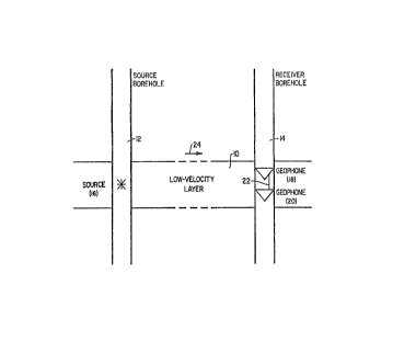
Fig. 1 is a schematic representation of two boreholes
utilized for continuity logging a low velocity lithographic
layer therebetween in accordance with a preferred procedure of
the present invention, wherein a seismic source is located in
a first borehole and two spaced apart geophones are located in
a second borehole.
Figs. 2a and 2b are schematic representations of two
boreholes utilized for continuity logging a low velocity
lithographic layer therebetween in accordance with an
alternate preferred procedure of the present invention,
wherein a seismic source is located in a first borehole and a
single geophone receiver is located in a second borehole at a
first location during a first sourcing event and at a second
location during a second sourcing event.
Fig. 3 is a representation of wave data developed between
boreholes in a typical coal lithographic structure using as a
receiver a horizontal motion sensitive geophone.
Fig. 4 is a representation of wave data developed between
boreholes in the same coal lithographic structure as depicted
in Fig. 3 using as a receiver a vertical motion sensitive
geophone.
Fig. 5 is a representation of wave data developed between
boreholes in the same coal lithographic structure as depicted
in Fig. 3 using as a receiver combination two vertically
spaced apart, vertical motion sensitive geophones.
Fig. 6 is a representation of wave data developed between
boreholes in a typical shale lithographic structure using as a
receiver a horizontal motion sensitive geophone.
Fig. 7 is a representation of wave data developed between
boreholes in the same shale lithographic structure as depicted
in Fig. 6 using as a receiver a vertical motion sensitive
geophone.
Fig. 8 is a representation of wave data developed between
boreholes in the same shale lithographic structure as depicted
in Fig. 6 using as a receiver combination two
-6-
CA 02018421 1999-09-08
vertically spaced apart, vertical motion sensitive geophones.
Descriptions of the preferred embodiments
Definitions of "body waves" and "guided waves" are set
forth below as aids in understanding the invention herein
described.
Body waves are defined as disturbances which can travel
throughout a medium. Body waves are not confined in space. In
a solid medium, two types of body waves can exist: namely,
compressional waves and shear waves. One type of wave which is
not a body wave is a surface wave; the amplitudes of surface
waves decrease rapidly with distance from the surface.
Under certain circumstances wave energy may be trapped
within a layer which is then known as a wave guide. Guided
waves have normal amplitudes in such layer, whereas the
amplitudes in the material surrounding the layer rapidly
approach zero with increasing distance from the layer. The
guided waves can be trapped or partially trapped in a low-
velocity layer by critical reflections of the waves at the
upper and lower boundaries of the layer. Because guided waves
have their largest amplitudes in the low-velocity layer, they
can be used to investigate discontinuities in the layer.
Guided waves are used to measure discontinuities in three-foot
coal beds even though the wavelength may be 100 feet long. In
coal geophysics, these guided waves are often called seam
waves or channel waves.
Now referring to the drawings, and first to Fig. 1, a
low-velocity layer or coal seam 10 is shown between a source
borehole 12 and a receiver borehole 14. The boreholes are
spaced at a distance from each other of several hundred feet,
for example, 2000 feet. The low-velocity layer is
CA 02018421 1999-09-08
known to exist, at least approximately, from existing well
logging or other data at the depth shown. For purposes of
illustration, the low-velocity layer sustains seismic waves
travelling therein at 9900 ft/sec., whereas all other layers
in the vicinity sustain seismic waves from the same source at
faster velocities.
Seismic source 16 in borehole 12 is a typical mechanical
seismic source, such as a vibrator, that can be actuated upon
command in traditional fashion well-known in the art to
established acoustic waves in the layers adjacent borehole 12
where the source is located. Geophones 18 and 20 are located
in borehole 14 at approximately the same depth as source 16 at
any given time. Each time the source is actuated the source
imparts substantially the same signal into the formation,
these waves travelling in the intervening layers between the
boreholes.
Geophones 18 and 20 both include a motion sensitive
sensing or receiving element of the same kind. That is, both
are either "horizontal" geophones or "vertical" geophones,
depending on the directionality of the sensing element. The
two geophones are spaced apart by a linkage 22 so as to
maintain the two geophones at the same separation. Typically,
the separation is two feet. Ordinarily, each geophone develops
an electrical voltage signal representative of the acoustical
wave that is sensed by the geophone. In discussing the wave
patterns presented in Figs. 3-4 and 6-7 below, it is assumed
that only one geophone is operational. However, in accordance
with the invention, both geophones are operable and are
electrically connected in such a manner that the output of one
of the geophones is subtracted from the other. This signal
development produces a "differenced signal", as more
completely discussed below with respect to the discussion of
Figs. 5 and 8.
Now referring to Fig. 3, a wave pattern development is
shown as it relates to a signal produced by a single hori-
zontal geophone, oriented for receiving waves in line with
direction 24 established by boreholes 12 and 14. The
_g_
CA 02018421 1999-09-08
boreholes are known to be 1940 feet apart. A low velocity
layer is known to be within 60 or so feet represented by the
diagram. That is, each vertical line separation represents a
distance of one foot. The velocity characteristics of the
layers traversed over the range of inquiry are shown at the
top of the diagram in feet per second, although it is assumed
that these layers are not precisely known in the beginning.
What is known is that a low velocity layer of interest lies
somewhere within the overall range.
The source and the receiver are located in their
respective boreholes at the same approximate depths and
sourcing is initiated. In this case, there is only one
operable receiver and that receiver is a "horizontal"
geophone. The receiver output recording is shown for the first
depth on the left side of the drawing. The source remains
fixed in the layer and the receiver is lowered one foot and
the source is again actuated to produce a signal on the second
line. This procedure continues for each successive line until
the whole diagram is developed.
There are two series of waves developed, the first of
which can be identified with the primary (compressional) waves
and the second with the secondary (shear) waves. There is no
significant difference in appearance of the low velocity layer
in the middle and that of the neighboring layers. That is, the
signals recorded for the low velocity layer are quite similar
to those recorded above and below the layer and the layer is
not readily identified.
Fig. 4 is developed in the same manner as Fig. 3, except
a "vertical" geophone is employed as the receiver. Again,
there are two groups of wave patterns, but the appearance of
the patterns are not significantly different for the low
velocity layer and the layer above and the layer below such
layer. It may be seen, however, that there is a phase reversal
in the middle that approximately identifies the low velocity
layer. Moreover, as will be seen, this part of the signal will
be enhanced when the differenced signal is developed.
-9-
CA 02018421 1999-09-08
Now referring to Fig. 5, a series of signals are
developed in much the same manner as for Figs. 3 and 4, except
that in this case, two "vertical" geophones connected together
two feet apart are used as a single receiver, the output
therefrom being the "differenced signal". The low velocity
layer is now sharply defined for both set of waves.
Furthermore, the entire boundary of the layer is defined, not
just the middle or center thereof. What is shown by the
diagram is not just that there is a low velocity layer in the
middle but that layer sustains the waves and therefore
indicates continuity of the layer.
A similar series of diagrams to that of Figs. 3, 4, and 5
are shown in Figs. 6, 7 and 8. In the latter case, the
structure under investigation is a shale structure, rather
than a coal structure. In this case the source borehole and
the receiver borehole are only about 300 feet apart. Thus, the
primary and secondary waves are not separated in time.
Otherwise, the conditions are the same. That is, Fig. 6 shows
the results of using a single horizontal geophone as the
receiver; Fig. 7 shows the results of using a single vertical
geophone; and Fig. 8 shows the results of using a pair of
vertical geophones spaced apart at a two-foot distance, the
output being the differenced signal. In the case of a shale
layer, the velocity characteristics of the entire layer may
not be homogeneous; however, the shale is comprised of lower
velocity material than its neighboring layers. Therefore, as
is true for the coal model, the large differenced signals for
the shale model also sharply define the edges of the layer
(Fig. 8) in a manner not evident by the single receiver
diagrams (Figs. 6 and 7). Furthermore, each of the three
sublayers of the principally detected layer are also
identified.
It should be noted that the data shown in Figs. 3-8 was
actually recorded with the source fixed in one location, with
the receiver being located at different positions or locations
relative to the layer. This demonstrates that the technique
described herein is able to distinguish cases
-10-
CA 02018421 1999-09-08
where the source is in the layer but the receivers are not in
the layer. This is important because the location of the layer
may not be precisely known. Moreover, the layer can in some
cases intercept the boreholes at different depths rather than
at the same depth, as heretofore assumed.
Referring back to Figs. 4 and 7, it will be seen that the
single vertical geophone in each case develops a phase
reversal in the approximate center or mid-section of the
detected layer. Thus, by the series of signals, one is able to
distinguish the boundaries and the center section of the
continuous low velocity layers in the formation.
Although Figs. 5 and 8 were developed using vertical
geophones, similar diagrams are possible by using a pair of
horizontal geophones. A vertical pair is preferred, however,
because they do not specifically have to be aligned in their
respective horizontal orientations to be in line with the
formation direction between the boreholes.
Moreover, hydrophones or receivers having pressure
sensing elements could also be employed, if desired, under
proper environmental conditions for their operations, such as
with a fluid-filled borehole.
While two particular preferred embodiments of the
invention have been shown and described, it will be understood
that the invention is not limited thereto, since many
modifications may be made and will become apparent to those
skilled in the art.
-11-