Note: Descriptions are shown in the official language in which they were submitted.
~ ?~ 3
DETACHABLE SKI OR TERRAIN MAP
Backqround of the I~nvention
The present invention relates to maps or other
two-dimensional direction guides, and more particularly, to
a map that can be detachably worn over a heavy outer
garment such as a ski jacket.
A common problem among even experienced skiers, is
unEamiliarity with all the trails of a ski resort not
frequently visited, and the resulting need to either
memorize or consult while on the slope, a map identifying
each trail and its various branchss and intersections.
Although ski facilities typically provide such maps at no
charge or at a nominal price, skiers encounter a major
inconvenience when they approach a fork in the trail, stop
and remove their gloves, pull a folded map out from a
pocket, read the map, fold up the map, insert it in the
pocket, and then put on their gloves before continuing down
the slope. Manipulating a standard map while wearing ski
gloves is virtually impossible, but removal of the gloves
for even brief periods of time produces significant
discomfort and possible danger to the skier due to exposure
of the skin.
U.S. Patent No. 4,415,106 issued November 15, 1983 for
a Map Holder attempts to overcome this problem by providing
a map holder having a printed surface on a thin flexible
substrate, or within a transparent sleeve, which is
attached to a skier's limb and provides a view of the map
without the~need~for the skier to remove gloves. The map
holder of the '106 patent suffers several disadvantages.
First, the size of~the map which may be visible by the user
upon lifting the arm and looking at the biceps~area, is
.
` quite limited - on the order of ten or twelve sguare
inches. For large~ski areas, the lnformation deslred by
most skiers simply cannot be legibly placed on such a small
~: :
, ~ .
. ~ ~
~: :
,
~J ~J,i.,
-- 2
map area, particularly if the skier wishes to view the map
through goggles or the like. Although certain major trails
may be shown in this manner, the branches at intersections,
along with indicia indicatin~ the deyree of difficulty,
cannot easily be shown.
Secondly, the lnformation content of the map is on the
exterior of the substrate and, whether or not covered by a
sleeve, is subject to the accumulation of ice, dirt,
freezing rain, and other elements which could easily cover
all or portions.of the map and prevent the skier from
learning important information such as the branching or
intersection oE a particular trail.
A further disadvantage of the map holder of the '106
patent is the relative permanence of the attachment to the
user's arm or other body part. The overlapping of the
projecting straps so that the interlocking of the
attachment means can be accomplished, requires delicate
manipulation and is virtually impossible to accomplish
while wearing gloves. Thus, the skier would attach the map
holder while in the lodge and not be able to remove or
replace it, nor replace the map with a map of another ski
slope, for example, without returning to the lodge or
removing the gloves with the consequent exposure of the
bare hands to the elements.
Summary of the Invention
It is the object of the present invention to provide a
ski map or similar terrain map, which includes a relatively
:large map display area which is protected from the elements
in use, and which can easily be secured to and detached
from the arm of the user as th~ need arises, while the user
wears bulky gloves.
.~ In general, the invention is directed to a ski or
~errain map for detachable ~earing on the arm, comprising
an elongated, flexible band having opposed longitudinal end
portions and having ski trails or other indicia of
,~ .
.
,: ." . ~ '' " '
.
.' :' . ' '' " ' ' ' '
'' ' ~ '', ', , :
~3~
topography or terrain depicted thereon. Attachment means
are carried by the band for detachably securing one
longitudinal end portion of the band to the other
longitudinal end portion of the band, such that the map
firmly encircles the user's arm.
~ ore specifically, the map in accordance with the
invention comprises a flexible, substantially flat, folded
substrat~ having first and second longitudinal ends and
inner and outer surfaces, the inner surface having a map or
similar information depicted thereon. A first attachment
means is secured to the outer surface adjacent the first
end of the substrate, and a second attachment means is
secured to the outer surface adjacent the second end of the
substrate for engagement with the first attachment means.
The substrate and attachment means are arranged so that,
whether or not folded, the substantially flat substrate
can be circled back on itself, band-like, while being
wrapped around a generally cylindrical central body such as
the user's arm, so that the first and second attachment
means can be joined to secure the terrain map to the
central body.
Generally, the attachment means are contained within
the perimeter of the map substrate, and, in a preferred
embodiment, a loop or other means are provided for holding
one end of the substrate substantially in contact with the
user's arm as the substrate is circled about the arm.
Preferably, Velcro or a similar strip having a multiplicity
of interengageable fibers is used as the attachment means.
Brief Description of_the Drawinqs
~;~ Figure l is an illustration of the invention in use on
a skier's arm;
Figure 2 is a plan view of the inner substrate surface
of the preferred embodiment, showing the map information
detailed thereon;
::
:::
-:
:~ :
:.~, ~ .
- . : . ,:
':
,,
'.3 ~
Figure 3 is a plan view of the preferred embodiment of
the invention, showing the substrate outer surface and
associated attachment means;
Figure ~ is a plan view of the map in accordance with
the invention, showing the first step of folding the
substrate into a band prior to wrapping the map around the
user's arm;
Figure 5 is a perspective view of the map with
preferred loop during wrapping;
Figure 6 is an illustration showing the invention
during a an intermediate step before being wrapped around
the user's arm.
Description of the Preferred Embodiment
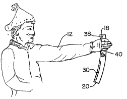
Fiyures 1-3 show the terrain or ski map 10 in
accordance with the present invention, secured to the arm
12 of a skier or other outdoor sportsman who encounters
inclement weather while following a trail or the like, In
the form shown in Figure 1, the map comprises an elongated,
flexible band having an inner surface not visible in Figure
1 on which is displayed the information useful to the
skier, and an outer surface 14 exposed to the elements.
The band encircles the arm and has one end wrapped around
the other end, preferably with sufficient overhang such as
indicated at 16, whereby the user may grasp the overhang
and unwrap the substrate from the arm.
The preferred map 10 is shown in Figures 2 and 3, as a
rectangular, flexible, substantially planar substrate
structure 28 having first and second longitudinal ends
18,20, the inner surface 22 thereof being visible in Figure
2 and the outer surface 14 thereof being visible in Figure
3. A first attachment means 26, such as an elongated
Velcro strip, is secured to the outer surface within the
perimeter of the substrate 28, and extending from a
location substantially adjacent the first end 1~ of the
substrate toward the second e~d 20 of the substrate.
; ~ '
~`
:
. . , - ~ - .
.
.
J ~
Similarly, a second attachment means 30 such as a mating
Velcro strip, is secured to the outer surface 14 within the
substrate perimeter at a location adjacent the second end
20 of the substrate and extending toward the first end 18.
In the illustrated embodiment, the substrate includes
a centrally located, longitudinally extending fold line 32
whereby the substrate may be folded once with the map or
inner side 22 folded onto itself, and the outer surface 14
remaining on the exterior of the folded substrate as shown
in Figure 4. Prior to folding, the substrate has opposed,
parallel first and second longitudinal edges 34,36. ~fter
folding of the substrate, the resulting band has
co-extensive first and second longitudinal edges 34,36
which effectively form one longitudinal edge, while the
longitudinal fold line 32 forms another effective edge.
In this embodiment, the attachment strips 26,30 extend
parallel to and adjacent the first longitudinal edge 34 and
the second longitudinal edge 36, respectively, such that
when the substrate 28 is folded as shown, the first
attachment means 26 and the second attachment means 30 are
aligned in substantially a straight line, along the first
and second substrate edges 34,36 which are now opposite the
fold line 32. It can thus be appreciated that i the first
end 18 of the band is retained in a stationary position and
the second end 20~ is wrapped around a central body such as
a user's arm so :as to encircle the arm, the second
attachment means~30 can be placed over and pressed down on
the first attachment means 26, thereby firmly ecuring:the
map to~the:user's arm.
: Depending on;the complexity of the:topography to be
depicted on the map, and the circumference or:length of the
body portion to which the~map will be attached, e.g., a
biceps or a thigh,~for example, the substrate 28 could have
no fold lines and be adapted to wrap around itself end to
end, in which case the first and seco~d attachment means
:::
~' ` : ~'
,
t~ ,,t~
would be provided along opposite ends 18,20, or attachment
means could be provided along the first and second edges
adjacent both the first and second ends 18,20 of the
substrate. In another embodiment, the substrate could be
folded longitudinally two times, i.e., along three fold
lines intermediate the longitudinal edges 34,36, in which
case the attachment means would be provided along either
side of one fold line, or along one fold line and one edge,
or other such arrangement such that when the substrate is
wrapped end to end, the attachment means, particularly in
the form of strips within the perimeter of the substrate,
align and then overlap each other.
The preferred form of each attachment means is an
elongated Velcro strip 26,30 or similar material having
interengageable fibers. The strips 26,30 are secured over
their full length to the substrate 28 and typically have a
length of nearly one-halE the length of the substrate 28 to
permit securement in any one of a plurality of overlapping
relations of the substrate ends 18,20.
The attachment means need not be in the form of
continuous strips, nor abut the edges oE the substrate, so
long as the attachment means provides adjustability of the
longitudinal dimension of the band.
The preferred substrate material is a thin, water
resistant, yet sturdy material such as is available from
the DuPont Company under the trademark Tyve~, which is
printable on at least one side.
As shown in Fiyures 4-6, means connected to one end 18
of the substrate 28, such as a loop forming strap 38 or the
like, enable the user to slip the arm 12 through the loop
~0 and thus hold or retain one end 18 of the band
substantially in contact with the arm or central body as
the band is circled about the body to secure one end to the
other. One end of the loop strap 38 may be permanently
attachod to one end of the substrate and the other end
.:
- :
.: .'. ' ' - ~ . :,
~ 'J
attachable, as by one or more Velcro tabs 42,42' to a
mating tab 44 on the outer surface 14 of the substrate (See
Figure 3). Furthermore, Velcro tabs 46,48 or the like can
be provided on the inside surface 22 (Figure 2) at the end
1~ of the substrate near the strap 38, so that when the
substrate is folded over along the Eold line 32 to form a
band, the longitudinal edges 34,36 remain together and are
not subjected to unwieldy bending while the band is
manipulated. In this way, the narrow, elongated shape of
the band is retained while the user wraps the band around
the arm.
It may thus be appreciated that after the substrate 28
is folded once as shown in Figure 4, and the arm passed
through the loop as shown in Figure 6, the user can readily
wrap the band in the manner shown in Figure 5, preferably
leaving some overhang 16 between the overlapped and the
underlying portion of the band. This permits easy pulling
of the overhang to disengage the attachment means 26,30,
and either the pulling of the arm out through the loop 40
or the disengagement of the strap 38. The user then
~; unfolds the band to expose the inner surface 22 on which
the terrain is depicted, makes a decision as to the path to
follow, folds the substrate 28 and either reestablishes the
loop 40 before inserting the arm through or places the map
10 near the arm and engages the tab on the strap,
preparatory to wrapping the band around the arm for
securement therewith.
It should be appreciated tha~ the invention as
described herein is well adapted to perform the objects set
forth above, and i5 an improvement over known devices and
techniques for providing ski maps carried by the outer
garrents of sk.o 5 or th~ like.
: ~ :
..
, : ' , -