Note: Descriptions are shown in the official language in which they were submitted.
a4113629-US
INERTIAL NAVIGATION SENSOR INTEGRATED OBSTACLE
DETECTION SYSTEM
Field of the Invention
The invention pertains to navigational
detection systems. Particularly, the invention
pertains to passive obstacle detection systems which
use passive (TV, FLIR) sensors and make selective use
of an active (laser) sensor. Work on the present
invention was done under NASA contract NAS2-12800.
Background of the Invention
Detection and avoidance of obstacles are very
important to the navigation of ground and air
vehicles. A system which can provide autonomous
obstacle detection and avoidance is needed for such
vehicles. The development of an autonomous system can
be achieved by the use of active sensors (millimeter
wave (MMW) radar, laser radar), passive sensors
(television or forward looking infrared (FLIR)), or a
combination of active and passive sensors.
An active system (MMW or laser) requires a
very specialized arid expensive sensor system. The
active system risks detection by the enemy in a battle
environment. Such system does not maximize usage of
passive sensor technology.
Various active systems are most advantageous
in certain kinds of environments. For all weather
conditions, MMW radar is better suited than laser
radar. However, for terrain following and avoidance,
and obstacle detection and avoidance, laser radar is
preferred because it is less susceptible to detection
by the enemy and has the necessary resolution to
detect wires (e. g., a 3 millimeter (mm) diameter wire
at a 40 meter distance), while MMW radar operating at
94 gigahertz (GHz) having a wavelength about 3mm, is
marginally satisfactory. A laser sensor is also
better than a I4riW sensor for detecting objects like
thin wires at oblique angles. For day/night operation
and countermeasure resistance, both laser and 1~IW
sensors are equally good. zn view of the above
trade-offs between 1~IW and a laser radar, a laser
ranging system is preferable. However, many laser
scanners are not adequate for such systems due to
their slow scan rate and a lack of a large field of
view (needed for providing a sufficient number of
-
alternate directions of travel for a vehicle when an
obstacle is encountered) for successful vehicle
navigation.
Compared to active systems, a passive system
has the benefit of covertness, simplicity, reduced
cost arid ease of manufacture. Obstacle detection
using passive sensors permits the use of two
fundamental techniques for ranging -- binocular stereo
and motion stereo (optical flow). With the binocular
stereo technique, ranging performance is a function of
the sensor resolution and the lateral displacement
between the two sensors: increased displacement
increases the maximum range measurement and improves
range resolution. For vehicles, sensor displacement
is limited by the dimension of the vehicle. The
technique of motion stereo utilizes one sensor from
which images are collected at regularly timed
intervals while the sensor is in motion. By observing
the amount of motion (on an image plane) that a world
point exhibits between frames and using knowledge of
sensor motion, range to the world point can be
computed. The resolution of motion stereo techniques
is limited only by the resolution of the sensor.
~~~v'~:
-4-
~ummarv of the Invention
The present invention uses an active laser in
combination with passive devices. The invention is a
maximally passive system, called ODIN (Obstacle
Detection using Inertial Navigation), for obstacle
detection and avoidance. It is based upon an inertial
navigation sensor integrated optical flow method and a
selective application of binocular stereo and laser
radar ranging.
The invention addresses the problem of
integrating inertial navigation sensor (INS)
information with optical flow measurements made over
multiple frames to compute the range to world points
that lie within the field of view of the sensors.
Context dependent scene analysis (used to characterize
the image regions) and multiframe filtering (used to
gredict and smooth range values) provide an improved
range map. The INS integrated motion and scene
analysis leads to a robust passive ranging technique
useful for obstacle detection and avoidance for land
and air vehicle navigation.
The obstacle detection system integrates
inertial sensor information with optical flow and
image characterizatian components to detect obstacles
and provide safe path for navigation. The system
includes the inertial navigation sensor, the optical
- ~~~3~ ~.
flow component system, the sensor suite consisting of
passive and active sensors, the context dependent
image characterization component system, qualitative
scene model, range calculations and interpolation.
The kind of inertial navigation sensor
information that is used in the obstacle detection
system include true heading (yaw), pitch angle, roll
angle, inertial vertical speed, North-South velocity
and East-West velocity which are used in the optical
flow component system and image characterization
component system. Additionally, position latitude,
position longitude, ground speed, true track angle,
body roll rate, body yaw rate, body longitudinal
acceleration, body lateral acceleration, body normal
acceleration, track angle rate, and inertial altitude
can also be used to synchronize different data rates
and to achieve increased accuracy.
The technique by which inertial navigation
sensor data is used in the obstacle detection system
includes the integration of inertial navigation sensor
data with the optical flow component of the system to
obtain instantaneous direction of vehicle heading
(focus of expansion) and to compensate the rotation
(roll, pitch and yaw) of the current frame with
respect to the previous frame. This leaves only the
translation motion between the frames which leads to
CA 02025971 1999-12-31
64159-1169
6
the determination of range values. The technique also includes
the integration of inertial navigation sensor data with the
context dependent image characterization component system to
achieve accurate segmentation from frame-to-frame by
compensating for rotation (roll, pitch and yaw) and translation
between frames.
The optical flow component system includes interest
point extraction, derotation, and matching between frames,
computation of the focus of expansion from inertial navigation
data, computation of range values to world points based on a
cameral model, matching of interest points using inertial
navigation data and image characteristics, and filtering of
range values over multiple frames to reduce noise effects and
obtain consistent range values.
In accordance with the present invention, there is
provided inertial navigation sensor integrated optical system
comprising: a scene analysis unit for receiving screen imagery
from sensors, and identifying and segmenting features of said
imagery; an integrated inertial navigation unit for detecting
rotational and translational movements of a vehicle; and an
inertial sensor integrated optical flow unit connected to said
integrated navigation unit for tracking the features of the
scene imagery based on said rotation and translational
movements of said vehicle, and to said scene analysis unit, for
creating a map based on said scene imagery wherein range values
to obstacles are calculated and alternate routes around the
obstacles can be determined.
Brief Description of the Drawings
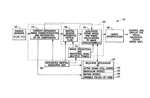
Figure 1 is a block diagram of the obstacle detection
and avoidance system.
CA 02025971 1999-12-31
64159-1169
6a
Figure 2 illustrates the major portions of the
inertial sensor integrated optical flow unit.
Figure 3 shows a three-dimensional coordinates system
in conjunction with a two-dimensional image plane and its own
coordinate system.
~~?a~~~.
Figure 4a illustrates overlapping
fields-af-view for several types of sensing.
Figure 4b shows the size of sensing field of
view which is required to detect the tickler sized
obstacles for a given range.
Figure 4c reveals the field of view and beam
coverage of a laser beam at a given range.
Figure 5 shows the sensor geometry for two
perspective views of the scene at two positions
separated by a given distance.
Figures 6a and 6b reveal two ways of
computing the distances of interest or world points
from the focus of expansion.
Figure 7 reveals the geometry for calculating
the range from an interest or world points viewed from
two different frames of imagery.
Figure 8 reveals an alternate approach for
range calculation from an interest or world point from
two frames of imagery.
Figures 9a, b, c and d show optical flow
results of synthetic data for the invention.
Figures 10a, b, c and d show optical flow
results using real data fox the invention.
Figure 11 reveals the hardware system for
data collection for the invention.
_8_
Figure 12 reveals a computer implementation
of the invention.
Brief Description of the Tables
Table 1 provides the parameters of the sensor
suite of the invention.
Table 2 gives the coordinates of synthetic
interest or world points used in the application of
the invention.
Table 3 indicates the location, row, pitch,
and yaw of the camera or sensor for two synthetic
frames used in the application of the invention.
Table 4 reveals the location, row, pitch, and
yaw of the camera or sensor for two frames of real
imagery in the invention.
Description of the Preferred Embodiments
The present invention, obstacle detection and
avoidance system 10, is maximally passive in that it
combines data obtained from an inertial navigation
sensor (INS) 26 with optical flow computations in
inertial sensor integrated optical flow unit 18 of
figure 1. The use of the INS data permits an accurate
computation of range to each world point based solely
upon the movement (between frames) of each world
point's projection onto the image plane. Figure 1
~~ ~~'~ ~
illustrates inertial sensors integrated optical flow
unit 18 and scene analysis unit 20, incorporating
context dependent image characterization and
recognition of its components unit 12, range
prediction and smoothing (using multiple frames) unit
14 and qualitative scene model and range calculations
(to image pixels/symbols) unit 16, using selective
application 24 of binocular stereo 54 (passive), laser
radar 52 (active) ranging, motion stereo 56 and
variable fields of view 57. The output is from range
interpolation unit 28 which is connected to unit 16.
The incorporation of inertial data from unit
26 into motion stereo 56 of unit 18 provides a robust
approach. Traditional techniques suffer greatly from
errors in the estimation of the location of the focus
of expansion (FOE) and from errors in matching world
points between frames. Inertial data enable unit 18
to compute the exact location of the FOE and remove
the effect that sensor motion (i.e., roll, pitch and
yaw) has upon the imagery; thus, the motion is
effectively reduced to pure translation. When the
motion consists solely of translation, the task of
world point matching is greatly simplified. The end
result is that more world points are assigned matches
from frame to frame and that the range measurements
have improved accuracy.
- 10 -
For a pair of image frames, the major steps
of optical flow method 30 as shown in figure 2 begin
with input frames, frame N-1 and frame N which are
digitized video or FLIR images, being read in from
passive sensors 22 along with units 32 and 34 wherein
interest points are extracted from input frames N-1
and N. The extracted interest points are sent to
interest point watcher 38 and interest point
derotation unit 40, respectively. Location of the
focus of expansion (FOE) (in both frames N-1 and N) is
computed in FOE computational unit 36. Computational
unit 36 output goes to interest point watcher 38.
Inertial measurement unit 26 outputs rotational
velocity information to derotational unit 40 and
translational velocity information to FOE
computational unit 36, range to interest points unit
42 and range interpolation over the entire area unit
44. FOE and the interest points in frame N are
projected onto an image plane that is parallel to the
image plane that captured frame N-1 (derotation of
frame N). Interest points in frame N are matched to
those of frame N-1 based upon four criteria. Range
is computed to each interest point in frame N that has
a match in frame N-1. A dense range map is created
using context dependent scene analysis and
interpolating between the computed range values.
6~~'~9'~~
The imagery to system 30 is digitized and
contains pixels addressed by row and column with the
origin of 2-D coordinate system 48 of figure 3 located
in the upper left corner of the image. The horizontal
axis, c, points to the right and the vertical axis, r,
is in the downward direction. This image plane 46 is
perpendicular to the x axis of 3-D coordinate system
50 and is located at a distance of the focal length F
from the origin with the z axis in the downward
direction. Therefore, the pixels in image plane 46
can be described in 2-D coordinate frame 48 as (c, r)
and in 3-D coordinate frame 50 by the vector (F, y,
z). The geometry described above is graphically
illustrated in Figure 3.
As shown in Figure 2, the data input to the
obstacle detection method 30 consists of a sequence of
digitized video or FLIR frames that are accompanied by
inertial data consisting of rotational and
translational velocities. This information, coupled
with the temporal sampling interval between frames, is
used to compute the distance vector, ~', between
each pair of frames and the roll, pitch and yaw angles,
(~, B, ~) , of each frame. Both ~ and
(~, e, fir) are crucial to method 30.
- 12 -
The movement of the world points' (i.e.,
interest points') perspective projection (onto the
image plane 46) is at a minimum near the FOE and, as a
result, the range to the world or interest points
nearest the FOE have the greatest amount of
uncertainty associated with them. The passive ranging
technique of binocular stereo 54 is most accurate near
the center of the field of view (where the FOE is
located most of the time) and is less accurate near
the edges of the field of view. In addition, the
binocular stereo 54 approach can function even when
the vehicle is stopped or hovering.
Wires and other small obstacles are detected
by active sensor 52 and passive techniques 54 and 56
because of the greater resolution 57 (Figure 1) and 64
(Figure 4a) required to detect such obstacles at a
range sufficient for obstacle avoidance. A trade-off
is made between the field of view and resolution of
the sensor(s). Since the system's field of view must
be large enough such that the vehicle has sufficient
(previously scanned) directions in which to steer when
obstacles are detected, the field of view of the
passive sensors can not be reduced: hence, laser range
scanner 52 and a narrow FOV passive sensor function in
conjunction with passive sensors 54 and 56 of system
10. The use of a simple (i.e., circular scanning)
- 13 -
laser range sensor 52, whose scan pattern is centered
around the FOE, is for the purpose of detecting only
small obstacles that lie within the vehicle's
direction of travel.
An illustration of the overlapping fields of
view 58, 60 and 62, respectively, of the three types
of sensing (aptical flow 56, binocular stereo 54, and
laser sensor 52) is in Figure 4a. A combination of
these types of sensors yields a robust obstacle
detection and avoidance system. Laser sensor 52
provides sufficiently high resolution not provided by
passive means 54 and 56. Limited field of view 62 of
laser beam sensor 52 sacrifices little covertness, and
the simplicity of its scanning pattern keeps
acquisition time short and hardware complexity low.
Gimbaled laser scanner 52 can also be used to quickly
investigate avenues of safe passage when obstacles
have been encountered which block the current vehicle
path. Multipurpose passive sensor FOV 64 encompasses
laser sensor FOV 62.
Figure 4b illustrates the size of sensor FOV
66 which is required to detect obstacles at a range of
40 meters in the flight path of rotorcraft 68. In
figure 4c, a 0.5 milliradian (mrad) laser beam width
having FOV 62 scans in circular pattern 70. Step size
S used in scanning is 0.70 mrad (in the plane of scan
~~~~~5~
- 14 -
circle 70), leading to 8,900 range samples in 2
radians. At a range of 40 meters, the laser beam is
2 cm in diameter which leads to an overlap of the beam
between samples. This overlap and small step size S
result in 4 range samples being acquired, at the range
of 40 meters, on a wire of 3 mm diameter which is
perpendicular to the tangent to scanning circle 70.
Laser range samples yield obstacle detections. The
range values are compared to a minimum acceptable
range threshold. World points having a range less
than this threshold are a danger to the vehicle.
Table 1 lists sensor types and typical
parameters for FOV, array size, instantaneous FOV, and
resolution.
Each sensor and its function may be
described, with emphasis on obstacle detection and
avoidance in the context of rotorcraft navigation.
First note that there are two types of sensor
mountings -- those of gimbal controlled orientation
and those of fixed orientation.
Motion stereo sensor 56, which is of fixed
orientation, is used to generate a sparse range map of
world features over FOV 58. The wide FOV 58 is
required for the sparse range map to provide suitable
options for rotorcraft 68 maneuvering when an obstacle
15
is encountered. Binocular stereo sensor 54 is used to
provide range measurements over a medium FOV 60 that
is centered within wide FOV 58 of motion stereo sensor
56. The purpose of binocular stereo sensor 54 is to
provide range samples within the area where the motion
stereo 56 measurements are the most error prone,
around the instantaneous direction of vehicle heading
(i.e., focus of expansion), which lies mainly within
the center of FOV 58. In addition, the binocular
stereo 54 measurements can be made when a vehicle is
stationary (e.g., when rotorcraft 68 is hovering or
when it is turning about its vertical axis without
forward motion), thereby providing a range map which
can be used to perform obstacle detection. Both the
binocular 54 and motion 56 stereo sensors use TV or
FLIR imagery to perform these measurements for day and
night operations.
Two kinds of sensors are mounted on a
gimbaled platform -- a variable FOV passive sensor (TV
or FLIR) 22 and a scanning laser range finder 52.
Placing the sensors on a gimbal allows their FOV's to
be constantly focussed in the direction of rotorcraft
travel, which is necessary since the sensors must be
able to detect large and small obstacles (such as
wires) which lie in the immediate path of the
rotorcraft. Laser range finder 52 actively scans for
~~~~~~'~1
- 16 -
obstacles and the passive sensor data are used to
perform motion stereo 56 measurements or to simply
extract two-dimensional (2-D) features which have a
high probability of being obstacles (e. g., linear
features of poles, wires, etc.).
An additional benefit of having gimbaled
sensors is that sensors' FOV's can be directed to an
alternate flight corridor when obstacles axe detected
in the current corridor of the vehicle. Turning the
sensors to the alternate corridor is necessary to
determine the suitability of the corridor prior to
executing a change in the flight path as part of the
obstacle avoidance task. The alternate flight
corridors are determined from the range measurements
made by wide FOV fixed position sensors 56 and 54.
In addition, the gimbaled sensors can be directed on a
potential landing site for the purpose of obstacle
detection grior to larding. In the air vehicle
scenario, the gimbaled sensors may also be controlled
by helmet mounted sensors.
Wide FOV 58 of motion stereo sensor 56 is
chosen to provide a wide, cleared area in which a
lateral maneuver may be performed if an obstacle is
detected. The vertical FOV is half of the horizontal
FOV due to the nature of nap-of-the-Earth flight (in
the air vehicle rotorcraft scenario) in which vertical
~?~~~d
- 17 -
maneuvers are not desired and lateral maneuvers are
emphasized. Binocular stereo sensor 54 has a smaller,
more conventional FOV 60 which is centered within
motion stereo FOV 58 to compensate for range
measurement error that occurs near the FOE in motion
stereo measurements and to provide range measurements
when the rotorcraft is not undergoing forward
translation.
The gimbaled sensors are designed to track
the FOE of vehicle motion. Tracking the FOE with the
high resolution passive and laser sensors provides the
most accurate ranging techniques where they are needed
most. The FOE is not the only location that needs to
be sensed by the gimbaled sensors. To perform
obstacle avoidance, i.e., to select a new flight
corridor, and to °clear~ a ground location prior to
landing, the gimbaled sensors must be directed
automatically by obstacle detection signals from unit
44 of figure 2, or manually by the pilot or
co-pilot. Laser 52 detection of an obstacle can be
confirmed with data from the passive, gimbaled sensor
whose line of sight is parallel with that of the laser
sensor.
Once range samples are obtained from the
various sensors, the next step involves obstacle
detection to be followed by obstacle avoidance. This
_ 18 -
requires that the computed range map for the scene be
sufficiently dense (so as to extract the
discontinuities in the range map: these
discontinuities correspond to the presence of
obstacles) or a model for the scene be available. A
model means a segmentation of the sensed image in
which the various segments are labeled as to their
respective types of terrain (sky, road, grass, etc.).
Context dependent image characterization, also called
"scene analysis," is applied to each frame, resulting
in a model of the scene which aids in the
identification of safe paths and aids the process of
increasing the density of the range map.
Interpolation of the range values obtained by
the optical flow method of system 30 of figure 2, is
aided by results of scene analyses. Having
information about the scene allows for intelligent
interpolation between the range values. For example,
when range values fall on two trees separated by 25
meters of unobstructed space, the scene model can be
used to prevent the range interpolation from
connecting the trees and blocking off the space
between them. The result is a more dense and accurate
range map which can subsequently be used for obstacle
avoidance.
- 19 -
The features within the imagery (TV or FLIR)
that are most prominent and distinguished, mark the
world points to which range measurements will be
made. These prominent world points, known as interest
points, are easy to extract from the imagery and have
the highest promise of repeated extraction throughout
multiple frames. The interest points within the
field-of-view of the monocular sensor are of
fundamental and critical importance to optical flow
calculations. The extraction and subsequent use of
interest points are described below.
Interest point selection involves computation
of distinguishable points which is accomplished by
passing a Moravec operator over each frame of
imagery. The operator is applied to each image pixel
(within a desired offset from the image border) which
was identified as a strong edge pixel by a Sobel edge
operator. The interest operator examines all pixels
within a square window, of side length L, that
surrounds each edge pixel and computes the relative
variance between pixel values. As each pixel within
the window is examined, the square of the difference
between its value and the values of its neighboring
pixels is computed and summed. Actually, four
different sums are recorded which correspond to the
same four neighbors relative to each pixel within the
iJ
window; there is a sum for the square of the
difference between the current pixel and its neighbor
to the right and likewise for three other neighbors
(below, below & right, below & left). After each
pixel under the window has contributed to the four
sums, the smallest of the sums, S, is selected and
stored as the pixel's value. A pixel is deemed an
interest point if its assigned value of S is greater
than the corresponding sum generated at each pixel
within a square window of side length K, centered on
the pixel in question. In the discussion that
follows, a pixel's value of S will be referred to as
its interestingness.
Implementation of the Moravec operator ranks
the detected interest points (pixels with a value of S
which is a local maximum) in the order of their
computed interestingness. This interest point
extraction routine works on the segmented image
obtained by context dependent scene analysis 12
(Figure 1). Segmentatian divides the image into M
uniform regions. Interest point routine returns only
the N points within each region which have the highest
values of S, where N and M are inputs to the program.
The result of returning only the best interest points
(in terms of S) in each region is that the processed
scene is intelligently covered with interest points.
-21-
If this were not the case, a small number of
occasionally adjacent regions will lay claim to the
major portion of interest points.
Note that not all regions within a scene can
contain reliable interest points (e.g., wave crests on
a body of water are not good interest points). As
mentioned above, image characterization 12 is used to
ascertain the goodness of regions prior to interest
point selection. Interest point selection can be
further improved by incorporation of Kalman filtering
techniques, which use inertial sensor data to track
and predict interesting point features.
Interest point derotation aids the process of
interest point matching. One must make it seem as
though image plane B is parallel to image plane A. If
this is done, the FOE and pairs of interest points in
frames A and B that match, would ideally be colinear
should the image planes be superimposed (see Figure
5). Figure 5 is an illustration of the sensor
geometry that records two perspective views of a scene
at two positions separated by a distance
lv~~t = Iced' (with no rotation of the sensor between
positions). When there is no rotational change
between image frames, there is a special property of
the perspective projection of a world point onto the
two image planes: the FOE and the projections of the
world point are all colinear.
- 22 -
To make the image planes parallel, denotation
is performed for each vector, (F,yi,zi), that
corresponds to each interest point in frame B. The
equation for the denotation transformation and
projection (in homogeneous coordinates) is:
F F F
z~= P ~ Raw = P C
R~, C~~
R,~
Re
R~
~ z~ z.
B
B
8
1 1
where
i o 0 0 ~ose o -sine
o
0 cos~p 0 1 0
sink 0 0
R~ - 0 -sink Re sinA 0 cosh
cosh 0 = 0
0 0 0 1 0 0 0
1
cos~r sin~y 0 0 1 0 0 0
-sin~y cos~r 0 0 0 1 0 0
R"'- 0 0 1 0 P= 0 0 1 0
0 0 0 1 1/F 0 0 0
and where NED (north, east, down) is the coordinate
frame in which inertial measurements are made. Use of
the NED frame assumes that vehicle motion is " local "
to a patch of Earth.
The matrix P projects a world point onto an
image plane and is used to compute the FOE, FOE =
P d, where d = ~Ot. The matrix CP'NED converts
points described in the NED coordinate frame into an
equivalent description within a coordinate frame
parallel to the A coordinate
- 23 -
frame. Likewise, the matrix CBNED converts the
descriptions of points in the B coordinate frame into
descriptions in a coordinate frame parallel to NED.
The matching of interest points is performed
in two passes. The goal of the first pass is to
identify and store the top three candidate matches for
each interest point in frame B, (F, y$ , zB ).
j 7
The second pass looks for multiple interest points
being matched to a single point in frame A. Hence,
the result of the second pass is a one-to-one match
between the interest points in the two successive
frames. For the present embodiment, a one-to-one
match of interest points is necessary. The
projection onto the sensor's image plane of an object
in the world will grow in size as the sensor moves
toward the object. This situation might imply that a
one-to-one match is nonsensical since what was one
pixel in size in frame A might become two or more
pixels in size in frame B. It is assumed that the
growth of objects, in terms of pixel size, is
negligible in the passive ranging for obstacle
detection scenario. All objects are assumed to be at
certain safe distances for vehicle maneuvering and one
pixel (of interest point quality) in two frames is all
that is required of an object's surface for the range
to the object to be computed.
- 24 - w~~~ ~ ~~
The first pass is described in the
following. To determine the candidate matches to
(F,yB , zB ), each of the interest points in
j j
frame A is examined with the successive use of four
metrics. The first metric makes certain that
candidate matches lie within a cone shaped region
bisected by the line joining the FOE and the interest
point in frame B. This metric limits candidate
matches to lie within the cone with apex at the FOE,
as shown in Figure 6(a). If an interest point in
frame A, (F,yA , zA ), passes the first
i i
metric, then the second metric is applied to it. The
second metric requires that the interestingness of
candidate matches is close to the interestingness of
the point that we are trying to match. (Figures 6a
and 6b show constraints used to aid the process of
matching interest points between frames.)
The third metric restricts all candidate
matches in frame A to lie closer to the FOE than the
points of frame B (as physical laws would predict for
stationary objects). This metric involves the
computation of the distances of the interest points
from the FOE, which can be computed in two different
ways. The first is the direct euclidean distance,
dl, between (F,yAi, zAi) and (F,yB3,
zBj), and the second is the distance d2 which is
the projection of dl onto the line joining
(F,yBj, zBj) and the FOE. The distance
measures are graphically illustrated in Figure 6(b).
Regardless of the way that the distance measure is
computed, it can be used to identify the closest
candidate matches to (F,yB , z8 ).
7 7
The fourth metric constrains the distance
between an interest point and its candidate matches.
For an interest point in frame A, Aj, to be a
candidate match to point Bj, it must lie within the
shaded region of Figure 6(a). The depth of the region
is determined by this fourth metric while the width of
the region is fixed by an earlier metric. By limiting
interest points, Aj, to lie in the shaded region,
one has effectively restricted the computed range of
resulting matches to lie between RmaX and Rmin.
The reasoning behind this restriction is that world
objects of range less than Rmin should not occur due
to autonomous or manual navigation of the vehicle,
thus avoiding potential collisians. Likewise, objects
at a range greater than Rmax are not yet of concern
to the vehicle.
The result of the first pass of interest
point matching is a list, for each (F,yB ,
j
zBj), of three or fewer candidate matches that
pass all metrics arid have the smallest distance
measures of all possible matches.
- zs -
The goal of the second pass of the matching
process is to take the matches provided by the first
pass and generate a one-to-one mapping between the
interest points in frames A and B. Initially, it can
be assumed that the best match to (F,yB , zB )
7 J
will be the stored candidate match which has the
smallest distance measure. However, there may be
multiple points, (F,yB~, zBj), which match to
a single (F,yAi, zAi). Hence, the recorded
list of best matches is searched for multiple
occurrences of any of the interest points in frame A.
If multiple interest points in frame B have the same
best match, then the point, B*, which is at the
minimum distance from the Ai in question, will
retain this match and is removed from the matching
process. The remaining B~~s are returned to the
matching process for further investigation after
having Ai removed from their lists of best matches.
This process continues until all of the interest
points in frame B either have a match, or are
determined to be unmatchable by virtue of an empty
candidate match list. Thus, the final result of the
matching process is a one-to-one mapping between the
interest points in frames A and B.
Given the result of interest point matching,
which is the optical flow, range can be computed to
~~~~~"~'1
- 27 -
each match. Given these sparse range measurements, a
range or obstacle map can be constructed. The
obstacle map can take many forms, the simplest of
which consists of a display of bearing versus range.
The next step is range calculation and interpolation.
Given pairs of interest point matches between
two successive image frames and the translational
velocity between frames, it becomes possible to
compute the range to the object on which the interest
points lie. One approach to range, R, computation is
described by the equation
X -.X~
R=dZ ,
x -x
where
x~ = the distance between the FOE and the center of the image plane,
x = the distance between the pixel in frame A and the center of the image
plane,
x' = the distance between the pixel in frame B and the center of the image
plane,
~Z = Ipltlt coca. = the distance traversed in one frame time, At, as measured
along
~a axis of the line of sight,
a = the angle between the velocity vector and the line of sight,
x' - x~ = the distance in :he image plane between (F,y~~,z~~ and the FOE, and
x' - x = the distance in the image plane between (FyB~,zs~ and (F,y,,~,,z~~.
These variables are illustrated in Figure 7,
wherein the geometry involved in the first approach to
range calculation is also illustrated. Figure 7 shows
the imaged world point in motion rather than the
sensor, thereby simplifying the geometry.
- 28 -
An alternate approach involves the
calculation of the angles aA and aB
between the translational velocity vector and the
vectors that describe the matched pair of interest
points in frames A and B,
IV~Ot sina8
A -
sin(aB - aA)
as indicated in Figure 8, wherein range calculation
requires the computation of angles between the linear
velocity vector and the vectors that describe the
matched pair of interest points. Both of the range
calculating techniques compute the distance to a world
point relative to the lens center of frame A (similar
equations would compute the distance from the lens
center of frame B). The accuracy of the range
measurements that result from either approach is very
sensitive to the accuracy of the matching process as
well as the accuracy of the inertial measurement unit
(TMU) data.
The task of range interpolation is the last
processing step required in the passive ranging system
(excluding any postprocessing of the range that may be
required before the processed data reaches the
automatic vehicle control and display systems). By
means or range interpolation between the sparse range
- 29 -
samples generated from the optical flow measurements,
a dense range map representing the objects within the
field of view is established. Essentially, this task
is surface fitting to a sparse, nonuniform set of data
points. To obtain an accurate surface fit that
physically corresponds to the scene within the field
of view, it is necessary that the sparse set of range
samples correspond to the results obtained from scene
analysis. As mentioned above, image segmentation,
context dependent image characterizations and
recognition of its components 12 (Figure 1) are used
to create regions from which a desired number of
interest points are extracted.
The type of surface fitting utilized is
significant because the resulting surface (i.e., the
range map) must pass through each of the range
samples. It would be particularly detrimental if the
surface passed under any range samples. Many
techniques of surface fitting are applicable to the
present task.
One type of range interpolation consists of a
fitting of planes to the available range samples.
This approach accomplishes the task efficiently and
succeeds in passing through each range sample. Any
technique of range interpolation needs to avoid
interpolation over discontinuities that occur between
~~~~~'~1
- 30 -
range samples on the surface of concern. With scene
analysis/segmentation, the smoothing of
discontinuities is avoided by interpolating only over
smooth regions or segments of the scene.
Range computation (based on 2 frames) is
further improved by estimating range over multiple
frames. The procedure for prediction and smoothing of
range using multiple frames 14 (Figure 1) is that for
all interest points in a pair of images, compute
matching confidence, measured and predicted ranges,
confidence in range and threshold the result are
computed to obtain the final range.
Matching Confidence of ith point in frame n is given
by
n ( tiA- he I I di - min di I
1_ 1_
max Ipe - ml~ + w2 m~ d' - m'n di
max IA~ ~ max {Iw~ I~B
min IA~ ~ min {Iw~ I~e
where wl, w2 > 0 and w1 + w2 = 1. Iix is the
interestingness of ith point in frame X. di is the
projection of ith point (point A in Figure 6b) on the
line connecting FOE with its match (point B in Figure
6b). Range confidence of ith point in frame n is
given by the following set of equations.
~~?~~~1
- 31 -
R wedded R'meawred ' Ri R
I
" " rr~ea.uea
ipredkted
1--
~ ml Rn + Rn
'preaaed
R'.' = - velocity " ,; " "
R"~t x time "
_ + C (R
R - R
ind 'measured
" ' 1 i
if (R
S O) then
i
pedlaaa if (R~
< 0)
'anr
R" =R~ =Rn and
R. R
'anal dia.d 'measuredR" ~
'qe ~~urod
i
C" -1 '~ R +R
i i
~~~
The inertial navigation sensor integrated
optical flow method has been used to generate range
samples using both synthetic data and real data
(imagery and INS information) obtained from a moving
vehicle. In the following, results are illustrated
using a pair of frames. Synthetic interest points
were generated from a file containing the 3-D
coordinates of 15 world points. Table 2 shows the 3-D
locations of these world points. In the same
coordinate system as the interest points are located,
table 3 lists the location, roll, pitch, .and yaw of
the camera at the two instances of time at which
synthetic frames A and B were acquired. The time
between frame acquisition is 0.2 seconds. Figures 9a,
b, c and d show optical flow results of sythetic
data. Figure 9a indicates the locations (circles) of
~~~~~'xl
- 32 -
the projection of the world (or interest) points onto
the first location (i.e., first image) of the image
plane where the field of view of the synthesized
camera model is 52.0 degrees x 48.75 degrees with a
focal length of 9 mm. Figure 9b shows the locations
(squares) of the projections of the world (or
interest) points onto the second location (i.e.,
second image) of the image plane and shows the new
locations (diamonds) of those projections after
derotation. Figure 9c shows the results of the
matching process in which circles are connected to
their corresponding diamond with a straight line and
the FOE is labeled and marked with an X. In other
words, the matching process results in displacement
vectors between the circles and the diamonds. The
final frame, Figure 9d, shows the computed range value
to each point resulting from each of the matches.
A pair of real images was selected to test
the capabilities of the optical flow method using real
imagery. Table 4 indicates the location, roll, pitch,
and yaw of the camera associated with the pair of real
image frames that were used. The field of view of the
camera for the real images is 52.1 degrees x 40.3
degrees and the focal length = 9 mm. The elapsed time
between the two frames for this experiment was 0.2
seconds. Figures 10a, b, c and d reveal optical flow
33 -
results using real data. Figure 10a shows the
locations of the extracted interest points obtained
from the first frame, drawn as circles. Similarly,
Figure lOb indicates the location of extracted
interest points (squares) and the corresponding
derotated interest point locations (diamonds). Since
the vehicle undergoes very little rotation between
frames, the derotated locations are nearly coincident
with the original point locations. The results (i.e.,
displacement vectors between circles and diamonds) of
the point matching process for the real imagery, with
the FOE indicated by an X, is shown in Figure lOc.
Finally, the computed range value to each of the
matched points is displayed in Figure lod.
Figures 11 and 12 show the hardware system
used for data collection by a ground vehicle and the
ODIN system implementation. Figure 11 is a diagram of
hardware system 80 for data collection for the motion
field of view for obstacle detection system 10 of
figure 1. VME chassis 82 (VME is an international
standard bus) comprises central processing unit (CPU)
84 (model 68020) having serial port 86 and system
clock 88 connected to CPU 84, an input/output proto
board 90 connected to serial port 86 and system clock
88 of CPU 84, and DataCube (Boston, MA) hardware 92
that includes Digimax board 94 and MaxGraph board 96
- 34 -
which is connected to system clock 88. A Honeywell
model 1050 ring laser gyroscope (RLG) inertial
reference unit (IRU) is connected to I/O board 90 and
provides inertial data with time stamping, which is
collected at 50 Hz. Sensor 100, which is a Panasonic
television camera, model WV-1850, having a focal
length of 25 mm and an FOV of 20 degrees by 15
degrees, is connected to board 96 and provides imagery
data. Output from chassis 82 goes to Panasonic
optical disk recorder 102, model T~-2023F. Recorder
102 is connected to serial port 85 and board 96.
Video frames to recorder 102 have a time stamp and are
recorded at 5 Hz sychronously with IRU data from
inertial unit 98 to chassis 82. The data in recorder
102 are for optical flow unit 18 of figure 1.
Figure 12 is hardware implementation 110 of
obstacle detection system 10 of figure 1. Computer
112 (model Sun 3/280) receives television imagery and
INS data. Data in recorder 102 of figure il go to
disk 114 of computer 3.12. Data are in the form of 500
x 480 pixel images sampled at a 5 Hz rate. The INS
data from unit 98 (from Honeywell 1050 RLG inertial
measurement unit (IMU)) are in terms of
_ 2~3~ ~~
latitude and longitude. The parameters are: a =
(ax, ay, az) ft / s2 (50 Hz): v = (vx, vy,
vz) ft / s(20 Hz): and w = (~, B,
degrees (20 Hz), wherein ~ is yaw, B is pitch,
and ~ is roll.
Computer 12 is connected to computer 116
(model Sun 3/60) via ethernet 118. Computer 116 has a
CPU, a math coprocessor and associated memory. It
operates in C language in 4.2 BSD Unix (release 3.5)
software. Computer 116 performs functions of system
10, particularly, units 18, 20, 24 and 28 of Figure
1.
35a
SENSOR TYPE FIELD OF ARRAY INSTANTANEOUSRESOLUTION
SIZE
VIEW (PIXELS)FOV mrods cm AT 40m
MOTION STEREO120x60 512x256 4.09 16.36
BINOCULAR 40x20 512x256 1.35 5.45
STEREO
MULTI-PURPOSE25x25 WIDE 512x512 0.852 3.41
0.7 2x0.72 NARROW512x512 0.025 0.1
LASER RANGE CENTRAL CIRCULAR0.5 2.0
ANGLE a 20 SCAN
Table
x (ft)y x
(ft) (ft)
1 100 25 4
2 95 -30 4
3 90 -10 4
4 85 -5 4
80 2 4
.
6 75 8 4
7 70 -8 4
8 65 10 4
9 60 0 4
55 5 4
11 50 -15 4
12 35 10 4
13 30 3 4
14 25 -5 4
20 2 4
Table 2
x y (ft)z ROLL PffCH YAW (deg)
(ft) (ft) (deg) (deg)
FRAME 0 0 -? 0 -15 0
A
FRAME 5 1 -6 5 -11 2
B
Table 3
x y (ft)z ROLL PITCH YAW (deg)
(ft) (ft) (deg) (deg)
FRAME -230.3-20.726.43 0.959 -1.179 -176.737
A
FRAME -231.7-20.836.44 1.222 -1.231 -176.852
i3
Table ~