Note: Descriptions are shown in the official language in which they were submitted.
-
2~53~0Z
Detailed Description of the Invention
Technical ScoPe
The present invention relates to an apparatus for
displayin8 a travel position, which is capable of
indicating a current position of a movins body on a road
~ap presented on a screen.
Prior Art
Recently, in attempt to guide a moving body, e.g. an
autbmobile, an apparatus for displaying a current position
of moving body has been developed, in which the current
position of the automobile is sequentially estimated in
--2--
2ns3so~
data may include an increased amount of errors in defining
its meandering portion having a series of sharply turning
courses.
Consequently, when a car travelling along a mountain
road, it is much difficult to make the car travel trace
match with the road patterns obtained on the basis of
digitally processed data and displayed on the screen.
Summary of the Invention
In view of the foregoing, the present invention was
made to provide an apparatus for displaying a current
position of a moving body, which, in case the moving body
departs from all the roads indicated on the road map
screen, can accurately correct its current position on the
screen by optimally performing an adaptive pattern matching
between the travel trace and the pattern of a road where-
along the moving body travelling, in due consideration of
an accuracy of the road map based on the digitized data of
the road depending upon its category, e.g., mountain road,
superhighway and other ordinary road.
The present invention provides an apparatus for
displaying a travel position which is capable of
recognizing the class of a roadway whereon the moving body
now is running and selecting pattern matching conditions
including various kinds of parameters and threshold values
in accordance with the recognized class of the road.
In accordance with this invention, apparatus for
displaying a travel position comprises: (a) means for
detecting a running distance travelled and a running
direction of a moving body; (b) means for calculating X-
and Y- coordinates of a current position of said moving
body; (c) means for renewably presenting, on a display
screen, the current position of said moving body on a road
A
o ~
map read out from a road map storage medium; (d) means for
accumulating data, in a memory device, on subsequent
current positions of said moving body to form data on a
travel trace; (e) means for matching between a travel trace
pattern of said moving body and a selected road pattern by
means of a given algorithm; (f) means for putting the
travel trace on the road pattern for correcting the current
position of said moving body deviated from the road on the
map; (g) means for determining what class of road the
moving body is running on by measuring a number of curves
per unit distance; and (h) means for changing a pattern
matching condition, including parameters and thresholds
usable in the algorithm according to the result of a road
class determination.
By another aspect the invention provides a machine-
implemented method for displaying a travel position, which
includes the steps of: (a) detecting a running distance
travelled and a changing direction of a moving body; (b)
calculating X- and Y- coordinates of a current position of
the moving body; (c) renewably presenting, on a display
screen, the current position of the moving body on a road
map read out from a road map storage medium; (d)
accumulating data, in a memory device, on subsequent
current positions of said moving body to form data on a
travel trace; (e) matching between a travel trace pattern
of the moving body and a selected road pattern by means of
a given algorithm; (f) putting the travel trace on the road
pattern for correcting the current position of said moving
body deviated from the road on the map; (g) determining
what class of road the moving body is running on by
measuring a number of curves per unit distance; and (h)
changing a pattern matching condition, including parameters
and thresholds usable in the algorithm according to the
result of a road class determination.
-- 4 --
2 ~
Brief Description of Drawings
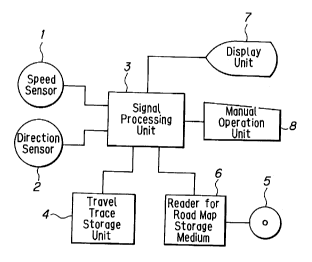
Fig. 1 is a block diagram showing a structure of an
apparatus for displaying a current position of a moving
body according to the present invention.
Fig. 2 shows an example of a road map image with a series
of dots representing sequential current car positions
appearing on a screen of the travel position displaying
apparatus shown in Fig. 1.
Fig. 3 shows an another road map image having sequential
current car positions departing from the road on the road
map.
Figs. 4(a) and 4(b) show how presumed current car positions
are put on a road and road branches for each increment of
running distance, respectively.
Figs. 5 shows how the last estimated car position is
related to corresponding presumed current car positions on
the road map.
Fig. 6 shows how a road pattern to be nominated for pattern
matching is formed.
Fig. 7(a) shows how a travel trace approximation is made by
using straight increments of equal length.
Fig. 7(b) shows how a selected road pattern approximation
is made by using straight increments of equal length.
Fig. 8 shows how a travel trace and a selected road pattern
are matched to each other.
Fig. 9 shows a discrepancy between a travel trace and a
road pattern when they are laid over each other in pattern
matching process.
Fig. 10 shows an equivalently illustrated discrepancy
between a travel trace and a selected road pattern when
they are laid over each other in pattern matching process.
Fig. 11 is a flow chart showing a procedure for recognizing
the road classification.
-- 5
2 ~
Referring now to the drawings, a preferred embodiment
of the present invention will be described in detail as
follows:
It will be observed from Fig. l that a travel position
displaying apparatus according to the present invention
comprises: a speed sensor l for detecting a car's running
speed; a direction sensor 2 which is capable of detecting
any variation in angular speed in the yaw direction and
generating a signal proportional to a change in direction
of the car running; a signal processing unit 3 composed of
a micro-computer which is capable of controlling the entire
system, determining the running distance by multiplying the
running speed measured by the speed sensor l by the time
elapsed, determining a change in the running direction of
- 5a -
2053~Q2
micro-computer which is capable of controlling the entire
system, determining the runnins distance by multiplyin8 the
running speed measured by the speed sensor 1 by the time
elapsed, determining a change in tlle running direction of
the car by multiplying the angular speed detected by the
direction sensor 2 by the time elapsed, and conducting a
cumulative algorithmic operation of vectors to determine
current car position in terms of X- and Y-coordinates for
each unit running distance; a travel trace storage unit 4
for sequentially storing the X- and Y-coordinates of the
current car positions as a finite continuous data set; a
road map storage medium 5 for storing a plurality of road
maps; a storage medium reading unit 6 for selectively
reading different road maps; a display unit 7 for presenting
a selected road map and the travel trace in terms of
sequential current car positions and its runnin8 directions
on an associated screen; a manual operating unit 8 for
sendin8 operation commands to the si8nal processin8 unit 3,
including commands for selecting a desired road map, setting
a starting position at a given point on the selected road
map, selectively indicating a travel trace, turning the
selected road map and/or the travel trace on the selected
road map, shiftin8 selected dots representing car positions
on the road map, enlarging or reducing a selected area in
the road map at a desired rate and performing other required
20535~2
operations.
In operation of thus constructed apparatus, a road map
selectively read out from the road map storage medium 5
appears on the screen of the display unit 7, and current
car positions are 8iven sequentially by dotting on the
selected road on the screen to indicate a travel trace which
the car has already run while the signal processing unit 3
is carrying out the necessary algorithmic operations to
renew the X- and Y-coordinates of a current car position in
the travel trace storing unit 4 wherefrom said data is read
out and send to the display unit 7. Thus, as illustrated in
Fig. 2, the screen of the display unit 7 shows the last
estimated current car position Ml, the direction M2 in which
the car is about to run from the last estimated current car
position, and sequential car positions M3 plotted one after
another from the starting position S.
The arrangement and operation described so far are the
same as the conventional travel Position displaying
apparatus described above.
In the conventional travel position displaying
apparatus, positioning errors are apt toqCcumulate as the car
runs a relatively long distance. Accordingly, the travel
trace will continue to increasingly deviate from the
selected road on the road map until the car can no longer
be on the road map on the screen.
20535C2
Such travel position displaying apparatus is improved
according to the present invention, wherein the travel
trace having sequential and last estimated current car
positions thereon is corrected and put in registration with
the true road found by selecting the road or roads in
vicinity of the last estimated current car position and
conducting the pattern matching procedure between the travel
trace and each of selected roads. Specifically, the number
of selected roads with respect to which the travel trace is
to be checked for similarity is reduced to a minimum, but
still adequate to permit the selection of true road and
exact location of the car on the road map. Thus, the burden
of patterq matching in the signal processing unit is reduced
to a minimum.
An example of selection of the roads is described as
follows:
The presumed current car position is set on the road
and all branches, respectively, whereon the car is supposed
to run the predetermined distance ahead from the starting
position or from the last estimated and corrected current
car position on the road map on the screen.
Referring to Fig. 4(a), if the car is running on a
straight road having no branches within a predetermined
distance Q from the last current car position P' corrected
by the pattern matching procedure, the subsequent presumed
20~3~2
current position X is set at the predetermined distance Q
ahead from of the last current car position on the same
road. Referring to Fig. 4(b), if the car is running on a
straight road having branches within a predetermined
distance Q from the last current car position P' corrected
by the pattern matching procedure, the subsequent presumed
current positions Xl, X2, and X3 are set at the
predetermined distance Q ahead from of the last current car
position P' on all the branches (where Ql~ Q2= Ql+ Q3
= Qlt Q4= Q )-
Each time it is detected that the car ran a givenconstant distance Q, the signal processing unit 3 carries
out the necessary algorithmic operation with reference to
the coordinates of the position of the selected road
appearing on the screen of the display unit 7 to
automatically put presumed current car positions on the road,
Each road on the road map is represented by a series of line
~egments obtained by linear approximation and the digital
values of X- and Y-coordinates of the road's line segments
are stored in the road map st~rage unit 5.
Next, a decision is made as to whether or not. the
distance between each of the presumed current car positions
and the last estimated current car position which deviates
from all the roads is within a given allowance. If the road
or roads are within such allowance, then the presumed
20535Q2
current car positions being within such allowance are
selected and will be subjected to pattern matching.
Referring to Fig. 5, the distances between presumed
current car positions X (Xl, X2, and X3) and the estimated
current car position P are indicated at D (D1, D2, and D3).
Presumed current car positions which meet the following
equation (1) are estimated.
D s a L = M
where " Q" stands for a unit distance set, for instance, at
100 meters; "M~ stands for a predetermined allowance, for
instance 50 meters; and "a " stands for a coefficient
pertainin8 to the accuracy of the car positioning with
reference to the running distance as a parameter and set,
for instance, at 5%.
Referring to Fig. 5, if the presumed current car
position X2 is selected as that meeting the equation (1),
the road whereon the presumed current car position X2
exists will be "nominated" for pattern matching.
Later, each time the car ran the predetermined distance
Q, the above-mentioned selection of the presumed current
car position X is repeated.
Referring to Fig. 6, the road nominated for pattern
matching is presented in the form of a pattern of a
constant length L which is formed of a series of thus
selected presumed current car positions X from the position
- 1 0 -
2053~Q2
P'. The road pattern of a fixed length L is compared with
the car's travel trace of the same fixed length L in the
following pattern matching process:
If the fixed length L of the pattern is short, a lar8e
number of road patterns similar to the trace pattern of the
car travel may be found on the road map increasing the
possibility of erroneous selection, while if the fixed
len~th L is long, the possibility of erroneous selection can
be reduced but a large amount of data may be needed for
pattern matching, thereby much time is required for data
processing and also the capacity of the data processing and
storing hardwares shall be increased. Accordingly, the
fixed pattern length L is usually set at a value within 600
to 800 meters.
First, a trace pattern LP of the car travel and a
nominated road pattern RP are converted into approximates
of broken lines of equal length, for instance, 10 meters as
illustrated in Figs. 7(a) and 7(b) respectively, and then
vectorial angles a i(i= 1, 2, 3, ...n) of approximated line
segments of the travel trace LP and vectorial angles
~ i(i= 1, 2, 3, ...n) of approximated line segments of the
nominated road pattern RP with respect to the X-axis are
calculated.
An rotation angle ~ of travel trace pattern RP is
determined by averaging differences (a i-~ i) between
2 ~ Q 2
pattern LP and in the nominated road pattern RP.
Taking a rosd configuration error into consideration,
pairs of vectors of the travel trace and road patterns,
angular difference of which is less than a predetermined
threshold value A, are omitted before the rotation angle
is calculated.
I ai ~ > A ................... (3)
Where "A" stands for a threshold value of angles between
paired vectors, which is usually set at about 45~.
Second, as illustrated in Fig. 8, the travel trace
pattern LP is shifted in parallel with the nominated road
pattern RP until the current car position P at the head
of the travel trace reaches to the last presumed current
car position x' at the head of the road pattern RP, and
then the travel trace pattern LP is turned about the
current car position P by the angle ~ so as to put it on the
road pattern RP.
Referring to Fig. 9, an area S formed between two
patterns after rotation of the trace pattern LP by ~ i8
calculated. The smaller the area S is, the more similar
both patterns are. Both patterns are considered to match
with each other if a value S/L which stands for the area S
normalized by the given fixed length L of the area S is
less than a predetermined threshold value C of similarity.
(S/L) < C .................... (4)
-lZ-
' , ,
20~35Q2
with each other if a value S/L which stands for the area S
normalized by the given fixed length L of the area S is
less than a predetermined threshold value C of similarity.
( S/L ) < C . . . . . . . (4)
The threshold value C for judging similarity of patterns is
usually set at about 8.
Referring to Fig. 10, the condition (S/L)<8 means that
when both the travel trace pattern LP and the nominated road
pattern RP are converted into straight lines respectively
and the area S formed between both these linear patterns is
determined by approximately calculating S= h- L/2, the
value "h" will be less than 16, i.e. the maximum deviation
between both patterns is less than 16 meters.
Finally, data on the current car position P are
corrected so as to make the current car position P appear at
a position x' on the nominated road pattern RP subjected to
the pattern matching process, and also data on the travel
trace pattern LP are corrected so as to bring the travel
trace pattern onto the matched nominated road pattern RP if
need be.
If the same matching condition such as pattern length
L, threshold value A of angular variation, threshold value
C of pattern similarity and etc. are applied to all cases
of matchin8 between the trace and road patterns, the
matching accuracy may be decreased, for instance, when the
- 1 3 -
-- 2QS~5Q2
car running along a mountain roadway having meandering
portions which have a decreased accuracy of digital map
representation.
Namely, any meandering portion of the mountain roadway
may have a large amount of error in digital mapping by
linear approximation method in compari$on with other
portions of the same roadway. Therefore, if a road pattern
of a given fixed length L for a meandering portion is
extracted from the digital map, said pattern may largely
deviates from the travel trace pattern of a given fixed
length L formed by the car running the meandering portion,
thereby the pattern matching may not be performed.
In case of a superhighway, since it has a small number
of curved portions and can be digitally mapped at high
accuracy, namely, with less amount of error in linear
approximation in comparison with ordinary roads in a city,
it is possible to further improve the matching accuracy by
employing matchin8 condition adapted for superhighway.
In view of the foregoing, the travel position
displayin8 apparatus according to the present invention
includes means for discriminating what class of road the
car is running on, and means for changing pattern matching
condition including parameters and reference values in
accordance with the discrimination result.
The means for changing the pattern matching conditions
-14 -
trace pattern and a road pattern and optimally adapted for
road classification are stored in a memory unit and will be
selecti~ely read out to use;
(2) Sets of matching condition, each of which includes a
set of parameters and threshold values necessary for
matching between a travel trace pattern and a road pattern
and optimally adapted for road classification, are stored
in a memory unit and will be selectively read out to use.
The means for determ-n;ng what class of road the
car is running on are included in the signal processing
unit 3 and the determination procedure is carried out as
follows:
First, each of line segments of equal length, by which
the car travelling trace of a constant length L is linearly
approximated, has an angle a to X-axis, i.e.
ai = {al, a2, a3, ~-- an }
which is differentiated numerically in 2-th order with
respect to ai" = al ~2 ~ 2 al~l ~ al,
then ai" = {al n ~ a2 ~ ~ a3 ~ ~ ~ ~ ~ an ~ } is obtained
Frequency of changing a sign of each element in
~i" = {al", a2", a3", ~-- an" }, i.e. the number k of
inflection points on the travel trace pattern is counted,
which is normalized by the trace length L, thereby
obtaining:
k' = k/L ~-- (5)
-15-
~ Q ~
where k' stands for the number of curves per unit distance.
Next, the measured value k' of the road is compared
with a threshold value K for determining whether the road
is mountainous or not:
k' > K ~-- (6)
If the value k' is more than the value K, the road is
judged to be mountainous. If the value k' is smaller than
the value K, the road is judged to be of ordinary class.
The value K is set at about 0.02.
Fig. 11 is a flowchart showing a procedure for
determination of the road classification.
The means for changing the pattern matching condition
in response to a result of determination of classification
of the road are provided in the signal processing unit 3
wherein the procedure will be performed in the following
way:
In case that the road is judged to be of ordinary
class the signal processing unit will employ standard
preset values for the pattern matching procedure, that is,
a common constant pattern length L = 600 ~ 800 meters for
the travel trace pattern LP and nominated road pattern RP,
a threshold value A = 45~ for angular difference and a
threshold value C = 8 for similarity of patterns.
In case that the road is judged to be of mountain-pass
class the signal processing unit changes the values of
- 16 -
r
20~35Q2
threshold value A = 45~ for angular difference and a
threshold value C = 8 for similarity of patterns.
In case that the road is iudged to be of mountain-pass
class the signal processing unit changes the values of
a parameter (L) and thresholds (A, C) to those optimally
adapted for the mountain road pattern matching. Namely,
since in case of a meandering portion of the mountain
road the larger distance error is induced as pattern length
L is increased, this parameter is modified to have a value
of L'= L x 0.5 so as to shorten both the trace pattern LP
and the road pattern RP to be compared with each other.
However, the value L' is set at 600 meters if L'~600 m
or it is set at 3000 meter if L'>3000 m.
In case of the mountain road, since there is a
considerable unevenness of differences between angles of
compared pairs of line segments of equal length by which
the travel trace pattern LP and the nominated road pattern
RP are approximated respectively in the form of a broken
line, the threshold value A for angular deviation is
changed from 45~ to 90~ .
Furthermore, in case of the mountain road, since there
is a large amount of error in configuration of mapped road,
the threshold value C for pattern similarity is changed
from 8 to 10 so as to slacken the condition of similarity
between the trace pattern LP and the road pattern RP.
20~3S02
Relating to means for discriminating what class of
road the car is running, it is also possible to employ a
variety of other methods such that, for example, a
dispersion of angular differences of compared pair of line
segments of equal length for approximating the trace pattern
into a broken line is processed statistically to recognize
class of the road.
It is also possible to adopt a variety of algorithms
other than the fore-described for pattern matching procedure
and, accordingly, to apply a variety of pattern matching
conditions which include parameter and threshold values to
be changed in accordance with the road classification and
wh ich are also selectable depending upon the selected
algorithm.
It is also possible to prepare and selectively use a
plurality of al80ritllms each of which is optimally adapted
to a specified class of roads, e.g. mountain-pass road,
superhighway or other ordinary road.
Effect
As be apparent from the foregoing description, the
travel position displaying apparatus according to the
present invention offers such an advantage that in matching
between a travel trace pattern and a nominated road pattern
on a road map so as to correct a current car position
- 1 8 -
2053SQ2
"
deviated from the road indicated Jthe map it is possible to
apply means for discriminating what class of road the car
is running on and means for changing the matching condition
including parameters and threshold values necessary for
pattern matching to be adaptable for the class of road,
e.g. mountain road, superhighway and other ordinary road,
taking into consideration that different class roads differ
from each other in their digital mapping accuracy.
Brief Description of Drawings
Fig. 1 is a bloc~ diagram showing a structure of an
apparatus for displaying a current position of a moving
body according to the present invention.
Fig. 2 shows an example of a road map image with a
series of dots representing sequential current car positions
appearing on a screen of the travel position displaying
apparatus shown in Fig. 1.
Fig. 3 shows an another road map image having
sequential current car positions departing from the road
on the road map.
Figs. 4(a) and 4(b) show how presumed current car
positions are put on a road and road branches for each
increment of running distance, respectively.
Figs. 5 shows how the last estimated car position is
related to corresponding presumed current car positions on
- 1 9 -
~ 2053502
the road map.
Fig. 6 shows how a road pattern to be nominated for
pattern matching is formed.
Fig. 7(a) shows how a travel trace approximation is
made by using straight increments of equal length.
Fig. 7(b) shows how a selected road pattern approxima-
tion is made by using straight increments of equal length.
Fig. 8 shows how a travel trace and a selected road
pattern are matched to each other.
Fig. 9 shows a discrepancy between a travel trace and
a road pattern when they are laid over each other in
pattern matching process.
Fig. 10 shows an equivalently illustrated discrepancy
between a travel trace and a selected road pattern when
they are laid over each other in pattern matching process.
Fig. 11 is a flow chart showing a procedure for
recognizing the road classification.
1 ~-- Speed Sensor
2 ~-- Direction Sensor
3 ~-- Signal Processing Unit
4 ~-- Travel Trace Storage Unit
5 ~-- Road Map Storage Medium
6 ~-- Reader for Road Map Storage Medium
7 ~-- Display Unit
- 2 0 -
20~3S02
8 ~-- Manual Operation Unit
LP--- Travel Trace
RP--- Nominated Road
-2 1-