Note: Descriptions are shown in the official language in which they were submitted.
2 ~
.
~ DESCRIPTION
:
~ NAVIGATION SYSTEM AND METHOD THEREFOR
~ ..
Technical Field
The present invention relates to a navigation system
.:
which is mainly used by a driver of an automobile and a
method therefor.
" .:,, ,
ackground Art
: A conventional navigation system having a storage
:; ,.:
:: device, a processing device, an input device, a display
device, sensors and the like and a navigation method to be
~:~ executed in the system may be classified into the following
two types on the basis of the contents displayed on the
display device as driving information provided for a user.
: One of the two types is a map display system which is
~ ~ arranged ln such a manner that a map is displayed on the
-. screen of the display device and a travelling locus, a
,
present position, a moving direction, a target, a target
direction, an instructed course or the like are indicated
- in the map. Another one is an arrow display system which
is arranged in such a manner that no map is displayed but
arrows respectively showing the target direction and the
. . . , , ~, ",.
~ course instruction at each intersection are lndicated.
: '
:
',
''.
:
':
:
:The map display system and the arrow display system
respectively have encountered the following problems:
According to the map display system, a driver must
look the displayed map while driving a vehicle. Therefore,
:
the driver must pay attention to man.y factors and thereby
the driver will be exhausted, causing a load tc be applied
to the driver. Furthermore, a risk will arise as the case
may be. Therefore, in the conventional map display system,
the display device has been disposed in a lower position so
that the driver cannot look it during driving, or only main
roads are indicated during driving. However, these devices
could not satisfactorily overcome the problems and thereby
a risk in terms of the traffic safety remains. Because of
. ..
the risk, the European countries have had a denial view on
the map display system and therefore they have not employed
the map display system.
.
: The arrow display system encounters the following two
.typical problems: In a case where the target direction is
: , ,:
shown by an arrow as one of the display modes of the
display device, the driver psychologically tends to earlier
turns to the right or left in accordance with the shown
arrow, causing a problem to arise, for example, the vehicle
strays in a resldential area. Furthermore, in a case where
the course is instructed at an intersection as another
" , .
~ ~display mode, timing at which traffic information collected
-3-
: ', ...
,
in a real time is indicated and acceptability for the
drivers, which becomes a serious problem for the aged and
female drivers, remain as unsolved problems, because there
is a course instruction as the assumption.
According to a basic system design concept used for
developing the conventional navigation system, the most
important factor for the navigation system lies in that the
present position of the user's vehicle, which is moving, is
accurately recognized in a map troad map) which has been
previously prepared. This system design concept is
similarly applied to both ~he map display system and the
:,
arrow display system.
However, the conventional navigation system developed
in accordance with the basic system design concept has been
restricted by the system design concept and thereby it is
of no practical use at present.
That is, since the vehicle such as an automobile moves
at considerably high speed, it is not so practical for the
driver even if the driver recognizes the present position
of the vehicle as a point of low accuracy on the road map
displayed on the display device. That is, it is rather
acceptable for the driver who is driving the vehicle, in
the aspects of the speed sensibility and the sense about
the positional relationship and the directional
relationship with respect to his target~ that the driver
";
~'
~- : 4
,-,
recognizes the state of the vehicle's movement as a line
while making the positional relationship with respect to
the target clear than recognizing the present position
indicated as a point, on the screen of the display device.
It is easier and more natural for the driver to recognize
the state of the vehicle's movement as the line than to
recognize the state of the movement as the point.
Furthermore, information about the state of the movement as
the line is more valuable as available drive information.
In addition, since the user's vehicle such as an automobile
must move while being restricted by a road in a different
manner from an airplane and a ship, it is more practical to
recognize the road on which the user's vehicle is moving at
this very moment while making the positional relationship
with the target for the use's vehicle clear than obtaining
the present position of the user's vehicle as a point.
Furthermore, if the present position of the user's
~ '
vehicle is intended to be accurately obtained, the load of
realizing the high accuracy becomes too heavy for the
navigation system. As a result, the cost for manufacturing
the navigation system cannot be reduced and thereby wide
using of the navigation system will be interrupted.
Therefore, the prirnary ideal of preventing the traffic
snarl and realizing the safety traffic cannot be achieved.
.~:,, ~ , .. .
" '
,,'','
,, .
, .,
It is very dangerous for the driver to drive his
vehicle while actually looking for a road. Therefore,
there has been a desire of a practical navigation system to
be developed as a system of aiding the driver to easily
reach the position of the target. According to the
conventional navigation system arranged in accordance with
the map display system, the driver must look for the
driving course set on the road map displayed on the display
device. Therefore, the dangerous factor cannot be
eliminated and thereby its practicality is insufficient.
Since the driver must pay attention to many things
during driving the vehicle, the load of the driver must be
reduced for the purpose of safely driving the vehicle.
Therefore, it is preferable that a naviga-tion system be
arranged in such a manner that information necessary to
select the course can be obtained at first sight.
According to the conventional navigation system
arranged in accordance with a route guide system in which
the driving course through which -the vehicle reaches the
target is indicated on the display device, an optimum
driving course is set in accordance with the relationship
between the start position and the target position at the
time of start of driving. According to the above-described
navigation system arranged in accordance with the route
guide system, it is actually difficult to drive the vehicle
~' .
:
-6
,~;
.'
while keeping the driving course in the actual road state
even if the driving course is indicated on the display
device. Furthermore, the degree of the danger can be
, increased due to stress given to the driver when the
determined driving course is instructed for the driver.
However, if the instruction by means of indicating the
: driving course is not made but only the present position of
the user's vehicle is indicated, the value of information
is insufficient. It is more dangerous to look for the
course in accordance with the present position shown on the
road map displayed on the display device than to instruct
the driving course.
It is important for the navigation system to, via the
display device, show the drive information which is
valuable to reach the target in a state in which the safety
cannot be deteriorated. In particular, intense stress is
; given to the driver if the op-timum driving course to reach
the target is determined before the start of driving and
the one fixed driving course is shown to the driver. In
order to prevent the state in which the stress is given to
the driver, it is preferable that the navigation system be
constituted in such a manner that the driver is able to
select a course to reach the target and the driver's
determination about the selected course is given priority.
, ~
~ J~
' '
':
As a result, the driver is able to drive the vehicle ~7ith
composure.
Furthermore, the current background in which the aged
and the female drivers increase must be taken into
consideration. In addition, the mental state and
recognition of the driver in a specific situation must be
considered.
Therefore, it is insufficient for the display device
to indicate the present position of the user's vehicle on
the road map. In addition, it is an excessive function to
indicate the driving course on the map.
An object of the present invention is to provide a
significantly practical navigation system and a method
therefor capable of overcoming the above-described problems
and meeting the above-described requirements by regarding
information about the movement state of a moving object as
a line as important and employing a concept of a "line
representing a passage through which the moving object is
moving at this very moment", that is a "travelling line",
. . .
whereby necessary and minimum practical information is
:
supplied to a user such as a driver to cause the user to
- independently select the course.
Another object of the present invention is to provide
a navigation system and a method therefor in which a novel
. . .
and practical naviga-tion display system is employed which
~,
~ '
is completely different from the conventional map display
: system and the arrow display system in terms of the display
method and which is arranged completely different from the
course guide system in terms of a navigation principle such
that the driving course is not set previously but a user is
able to independently make the driving course while
; selecting a course in accordance with the determination
~:. about driving made by the user.
'~ '
~isclosure of the Invention
According to the present inventlon, there is provided
a navigation system and a method therefor arranged in such
a manner that coordinates and various data items about
positions are stored in a storage device at need, a
~ processing device performs a predetermined process when
~ predetermined information is supplied via an input device
~ and a display device indicates the result of the process,
wherein, when information about a passage through which a
moving object is moving at this very moment is supplied by
means of any one or some of a receipt of a signal
. transmi-tted from a transmitter, a receipt of satellite
electric waves, detections of a distance sensor and an
azimuth sensor and an operation of a user, a line
: (hereinafter referred to as a "travelling line" at need)
representing the passage through which the moving object is
':
,'' ,"''
'.
;, ' '
,
.
' ,' ' ' '
,
, .
9~
:
moving at this very moment is, together with information
about a target such as a target position, indicated on the
screen of the display device while always making the
positional relationship with the target clear
The "passage through which the moving object is moving
at this very moment" means a passage through which the
"moving object", on which the main unit of the navigation
system is mounted, is moving at this very moment. For
example, the passage is a passage the start point of which
is defined by a point at which turning to the right/left is
performed at an intersection and end point defined by a
final point to which the moving object is able to reach in
a case where the moving object moves without performing
turning to the right/left after turning to the right/left
at the intersection The passage through which the moving
object is moving at this very moment is changed in
accordance with the movement of the moving object while
repeating turning to the right/left Therefore, in
principle, information about a novel passage through which
the moving object is moving at this very moment is obtained
whenever the passage through which the moving object is
moving at this very moment is changed, and when obtaining
the information about the novel passage, a line
representing the passage through which the moving object is
.....
.~ moving at this very moment is generated. Thus, the line
,i, .
:, '
' ' :
" ' ' '
- l o~
representing the passage through which the moving object is
moving at this very moment shown on the screen of the
display device is updated. The "information about the
passage through which the moving object is moving at this
very moment" means information from which data about the
shape and the position of the passage through which the
moving object is moving at this very moment can be finally
obtained. The meaning of the line representing the passage
j: -
through which the moving object is moving at this verymoment, that is, the "travelling line~' will be concretely
described later.
The navigation system and the navigation method
according to the present invention are characterized in
::,
that the travelling line (the line representing the passage
through which the moving object is moving at this very
moment) and the target for the moving object to reach are
always indicated on the screen of the display device, and a
driver or the like can move to reach the target by
selecting freely a-t the driver's will a passage through
which the driver or the like wants to pass on the basis of
the recognition of the positional relationship between the
travelling line and the target on the screen. The
"
~ travelling line indicated on the screen of the display
;j device is updated whenever the driver selects another
.... . . . .
. passage due to turning to the right/left. As described
~"
' '
',.~-
'
.: .
,~.,,
above, the travelling line is updated with the movement of
the moving object in accordance with a selection of the
driving course at the driver's will or the like.
Therefore, the travelling line is completely different in
terms of its concept from the driving course which is
described in the background art and which is previously
determined before the start of driving between the start
point and the target.
The present position of the moving object is at need
indicated on the screen of the display device. Since the
present position of the moving object can be ascertained
from the conditions when making the travelling line
indicated or the positional relationship with the target,
the particular necessity of clearly indicating the present
position is not required. Furthermore, it is not necessary
to, on the screen of the display device, display the road
map about a region in which the moving object is moving at
this very moment.
As will be described below, the present invention has
a plurality of embodiments so as to select a proper
embodiment in accordance with the purpose and way of use of
the present invention. According to these embodiments, a
variety of configurations for variously generating the
travelling line and states of indication mode on the screen
... ....
of the display device are explained.
: ,,
' ' ':
' "'' :
: ' 12
'
.:
. . .
A preferred aspect of the present invention lies in a
. . .
navigation system and a method therefor arranged in such a
manner that transmitters are disposed in the passages and a
siqnal to be transmitted from the transmitter is given data
about the shape and the position of the passage in which
the transmitter is disposed, whereby, when a main unit of
the navigation system mounted on the moving object and
having a signal receiving function receives the signal, a
travelling line representing the passage through which the
. . .
: moving object is moving at this very moment is indicated on
the display device. Furthermore, a configuration may be
constituted in such a manner that a code is given ~o the
: signal to be transmitted from the transmitter, data about
: the shape and the position of the passage is stored in a
. data storage device of the main unit, data about the shape
. and the position of the passage which corresponds to the
code read from the signal is retrieved from the data stored
in the storage device on the basis of the code read from
~ the signal and the travelling line is indicated on the
. basis of the retrieved data.
: A preferred aspect of the present invention lies in a
navigation system and a method therefor arranged in such a
- manner that data about the shape and the position of a
passage is stored in the data storage device, data
corresponding to the passage through which the moving
.
:
~ -13_ ~ 0~
'
.
;
object is moving at this very moment is retrieved from data
stored in the data storage device when information which
can be recognized by a user when the user moves through the
passage and with which the passage through which the moving
object is moving at this very moment can be specified and
the travelling line is indicated.
. A preferred aspect of the invention lies in a
; navigation system and a method therefor arranged in such a
manner-that the present place (present position) is
estimated on the basis of satellite electric waves, or a
. distance sensor and an azimuth sensor, a passage which is
nearest to the estimated present position is discriminated,
data about the shape and the position of the passaqe is
: retrieved from data stored in a data storage device and it
is indicated as a travelling line. A configuration may be
employed which is arranged in such a manner that a locus of
a passage which can be considered that the moving object
has passed through is obtained on the basis of the
~ estimated present position, the passage through which the
moving object has passed i.s discriminated on the basis of a
~- ~ result of a comparison made between the locus and the shape
of the passage, data about the shape and the position of
the passage which is positioned in front of the passage
through which the moving object has passed and through
. .
~ which the moving object will pass through if it does not
~ ~14-
''
,':
turn to the right/left is retrieved-from data stored in the
data storage device and it is indicated as a travelling
line.
~ preferred aspect of the present invention lies in a
navigation system and a method therefor arranged in such a
manner that it comprises a distance sensor and an a~imuth
sensor, the passages which intersects each passage are,
together with the state of advancement into the
intersection, stored, the distance between the
intersections is stored, the distance from the initial
, .
. movement position is detected by the distance sensor, the
;~ distance from the initial movement position to each
:' ':
~i, intersection is obtained, the stored distance and said
'. quantity of detection are subjected to a collation, the
- intersection which is passed at the time of the detection
, .
'~ - is estimated on the basis of the collation, the passage:; .
~i~ . into which the moving object has been advanced is estimated
: on the basis of the detected state when the state of the
. advancement into the intersection is detected, data about
the shape and the position of the passage into which the
moving object has been advanced is retrieved from data
. stored in the data storage device and a travelling line
representing the shape and the position of the passage is
'~ indicated on the display device. Another configuration may
, . . ................................ ..
~~ be employed in which the state of advancement of the user
, , : .
.''', ''
:
. .
:' '
~ -15- 2 ~ 8
~.
into the intersection is supplied in place of the detection
of the azimuth performed by the azimuth sensor to estimate
the passage into which the user has advanced, data about
, . . .
; the shape and the position of the passage into which the. . .
: user has advanced is retrieved from data stored in the data
': storage device and the passage is indicated as the
....
travelling line.
As described above, according to the present
invention, generating and indicating of the travelling line
can be realized by a variety of configurations. In the
configuration according to the present invention, a passage
to the end point of the passage which can be selected if
the moving object moves without performing turning to the
right/left or along a course in which the driving is
regulated is, as information necessary and sufficient for a
driver or the like to select a course and in the form of
information called the "travelling line", indicated on the
screen of the display device. The concept of the display
informatlon called the "travelling line" has not been
disclosed according to the conventional navigation systems.
. .
The navigation system and the method therefor
. according to the present invention treat the target for the
.~, , .
moving object to reach as follows:
~- The configuration is constituted in such a manner that
the coordinate positlon of the target is supplied so that
'~', '
'~'
,
. , ~ .
.
-16- ~&~
,
,;
codes about name of the target, the number given to the
.:
target and the name are supplied to retrieve data about the
target on the basis of the supplied information and
information about the target such as the target position is
indicated on the screen of the display device.
In a case where information supplied to the main unit
or information supplied for -the purpose of retrieving data
about the passage to indicate the travelling line includes
information about the present position, an area to which
both the present position and the target position belongs
is retrieved and the area is displayed on the display
screen and as well as the target position and the
travelling line on which the present position or an
equivalent position in place of the present position are
positioned are indicated on the display screen. The
supplied information including information about the
present position is exemplified by a case in which a signal
transmitted from the transmitter includes information about
the position at which the transmitter is disposed, a case
in which inputtinq is performed in accordance with the name
of the intersection, the name of a place, the lot number
and the name of the roadside facility, a case in which a
specific coordinate position is supplied, a case in which
the code numbers which correspond to elemen-ts showi.ng the
, . . . . .
above-described positions substantially show the equivalent
-"
~ 7-
:''
:
:- place in plzce of the pLesent position and a case in which
information about the estimated present position is
; ~ supplied.
As described above, information about the target (for
example, the target position) and the line (travelling
line) representing the passage through which the user's
vehicle is moving at this very moment are always indicated
on one common display screen. Therefore, the user is, at
first sight of the display screen, able to determine the
selection of the course through which the user is able to
reach the target on the basis of the relationship with the
actual driving situation.
That is, when the driver or the like, who is a user,
looks the travelling line indicated on the display screen,
the user is able to quickly, easily, extemporaneously and
at free will determine to go straight along the passage
through which the user's vehicles is moving at this very
' moment, or turn to the right or left into another passage
in accordance with the posi.tional relationship with the
target.
The travelling line serving as information with which
the moving object is able to reach the target is superior
information with which the determination is made to
conventional information used in the conventional
. .....
navigation technology such as the locus, the present
~ . .
3 ~
~ -18-
. .
position, the target direction and the moving direction.
Furthermore, the configuration according to the present
invention is arranged in a manner difEerent from the
: configuration in which a previousl.y set optimum driving
course is instructed but the same is arranged in such a
manner that the determination made by a driver or the like
; is given priority. Therefore, the load and danger of the
~ driver can be eliminated from the psychological viewpoint
h and a significantly preferable éffect can be obtained in
terms of the traffic safety.
In addition, information, that is, the present
position of the moving object is not obtained but only the
A
: line representing the passage through which the moving
object is moving at this very moment must be grasped.
,
~: Therefore, the restriction involved in the conventional
. : system in which the driving course and the moving object
must be continuously aligned with each other on the road
map displayed on the display screen can be eliminated. As
.~ a result, the load in terms of the accuracy applied to the
: .:. .
. : navigation system can be reduced.
If information for specifying the passage is once
supplied, in accordance with the most simple configuration,
the travelling line can be generated and indicated.
Therefore, the ensuing necessity of estimating the present
: .''
:
, . .
: .
~lg~ J~
, :.,
position by means of the navigation system can be
eliminated to make it serve as the navigation system.
In each mode of the present invention, the
configuration is constituted in such a manner that the
present position of the user's vehicle or an equivalent
place in place of the present position, an intersection
line representing the passage which intersects the passage
through which the user's vehicles is moving at this very
..... .
moment, the intersection of the travelling line and the
intersection line, the moving direction and the locus are,
as secondary determination information, indicated. As a
result, a variety of requests made in each mode can be met
while making the indication of the travelling line to be
the basic function.
Furthermore, a preferred aspect of the present
invention can be constituted ln such a manner that data
about the shape and the position of the passage at which
the target confronts is stored in the data storage device,
data about the target position and data about the passage
which confronts the target are retrieved when a target is
set, the target position is indicated on the display device
and as well as a line representing the passage which
confronts the target is indicated on the display device.
Another configuration example may be arranged in such a
manner that data about the shape and the position of a
; . . ' .
-20- ~3~
, ~ .
.':,
. .
,. . .
passage which constitutes a course through which the moving
object is able to properly correctly reach the target from
a main passage positioned near the target is, together with
data about the shape and the position of the passaqe at
which the target confronts, stored in the data storage
device. Thus, when a target is set, data about the target
position and data about the shape and the position of the
passage at which the target confronts are retrieved and as
well as data about the shape and the position of the
passage which constitutes the course through which the
moving object is able to reach the target is retrieved and
the target position and the line representing the passage
at which the target confront are indicated on the display
. .
~ device and as well as the line representing the passage
. .
which constitutes the course through which the moving
object is able to reach the target is indicated on the
display device.
AS a result of the thus-made configuration, the
passage and the travelling line with which an access to the
target can be made are clearly shown on the display screen.
Furthermore, by arranging the configuration in such a
manner that the passage which is able to be adapted to the
directional regulation is formed into data and the above-
described passage is indicated or the regulation is clearly
~ ' ! . I ! .
.,
.'," '
'","'"'
.
:
.',' '
'
. ,
'''
-21~
. . --
~ .'
indicated, the moving object is significantly easily able
to reach the target.
Furthermore, the present invention can be constituted
in such a manner that the target and the travelling line
are not indicated on one display screen. According to this
example of display, the configuration is constituted in
such a manner that the target direction is retrieved while
making the central point or arbitrary points of an area
displayed on the display screen in which the travelling
line is indicated to be a start point and the target
direction is, together with the travelling line, indicated
by an arrow or the like.
As a result of the thus-arranged configuration, in a
case of a mode of the present invention in which the
present position and an equivalent position in place of the
present position is not used as the assumption, for
example, in a case where the travelling line is indicated
when a user supplies the name or the code of the passage as
information, in a case where it is difficult to display the
target and the travelling line in one area due to the
restriction caused from data, or in a case where the
present position cannot be detected due to some trouble,
the system according to this mode is able to serve as a
supplementary function to aid the driver or the like to
select the course. Furthermore, since the travelling line
. . . .
"~
:,. .
.. . .
:'
-22- 2~
, .
',''''.''
.. ...
,.. .
is indicated, the arrow representing the target direction
does not trouble the user. Therefore, this mode of the
present invention is able to serve as a satisfactory
effective navigation system.
Furthermore, according to the mode of the present
invention in which the distance sensor and the azimuth
sensor are not required, the navigation system and the
method therefor according to the present invention can be
utilized as a portable apparatus adaptable to a pedestrian.
Also according to this mode, the travelling line and the
target are indicated in a manner different from the
conventional configuration in which the map is displayed.
Therefore, the user is able to recognize the direction of
movement to reach the target.
Since an effect as a navigation system and a method is
obtained because thé target and the travelling line are
indicated on the display screen, the contents of display
can be simplified, causing a plurality of advantages to be
realized.
In a case where the arrow display system, the size of
the display screen can be reduced. However, a
predetermined size of the display is required in the map
display system. In a case where the present position is
shown, it must be collated with the circumferential state
after it has been confirmed in the map. Therefore,
~'',, '''
~'''
, .
-23- ~ 8
:.
,,
.
background information must be sufficiently shown in the
map, causing a necessity to arise in that the size of the
display screen must be enlarged.
On the other hand, since background information is an
indispensable factor according to the present invention,
the size of the screen can be reduced and as well as a wide
area can be displayed as practical and meaningful
information.
By combining the navigation system and the method
therefor according to the present invention with
information about traffic snarl, the user is able to
previously detour the snarl. Furthermore, an aid system
can be provided with which driving can be performed in such
'
- a manner that a driver is able to select a passage to
detour the snarl after the driver has confirmed the actual
degree of the traffic snarl.
~ According to the present invention, by combining with
'; a navigation system of another course guide system, it can
:: .
be provided as information source to freely select the
: course which is deviated from the instructed course in a
case where although the optimum course has been instructed,
. the moving object is deviated from the optimum course
during driving or in a case where the instructed course is
not accepted by a female or the aged driver because the
.. . . .
: '
' .~
. ' '
-2~-
' 2 ~ 3 ~
traffic volume is too large in the instructed course or the
traffic speed is too high in the above-described course.
, .
Brief Description of Drawings
Fig. 1 is a block diagram which illustrates an
embodiment of a navigation system according to the present
. invention;
Fig. 2 is a flow chart ~hich corresponds to
embodiments 1 and 2i
- Fig. 3 is a flow chart which corresponds to embodiment
: ; 9;
Fig. 9 is a flow chart which corresponds to embodiment
~; 6;
Fig. 5 is a flow chart which corresponds to embodiment
8;
; Fig. 6 is a flow chart which corresponds to embodiment
.: .
, 10;
Fig. 7 is a flow chart which corresponds to embodiment
12;
Fig. 8 is a flow chart which corresponds to embodiment
: 29; and
i Figs. 9, 10 and 11 illustrate typical examples of
, .
indication made on the screen of the display device in a
case where the navigation method according to the present
.,: .
invention is carried out.
" ' .
. ' .
.
~ ~25~ ~ 8
,: -
Best Mode for Carrying Out the Invention
Embodiments of the present invention will now be
described hereinafter with reference to the drawinqs.
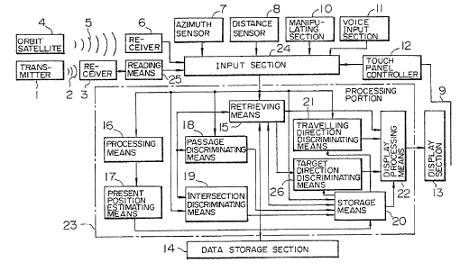
Fig. 1 illustrates the configuration of a navigation
. system according to the present invention. The illustrated
navigation system collectively includes all of the
components. It is preferable that the elements of the
system may be selectively employed at the time of a
- practical use as described later. The sequence illustrated
. .
by each of the illustrated flow charts partially shows the
characteristic sequence of the navigation method according
to the present invention. Therefore, they may be combined
with one another as desired at a practical use.
The navigation system shown in Fig. 1 is composed of
two sections. A first section comprises a main unit with
anauxiliary device,which is mounted on a "moving object"
such as an automobile or a human body. The main unit has a
function of receiving a signal given from the outside, a
funetion of generating data by utili~ing its internal
deviee and the auxiliary device and a func-tion of making
the obtained siqnal or data. A second section is an
external unit disposed on the outside of the main unit,
the second section being a unit for supplying a signal
ineluding required information to the main unit. Then, the
., , , . .:
deseription will be made hereinafter on the assumption that
:.
:,.
;
,:
.: -2~-
' the "moving object" ls an automobile. The automobile
provided with the main unit is defined as a "userls
~ vehicle".
-~ ~ Referring to Fig. 1, a signal 2 emitted from a
transmitter 1 disposed on a passage includes data showing
the shape and the position of the passage on which the
transmit-ter 1 is disposed, or a code for retrieving the
data relating -to the passage, or other information about an
intersection and a crossing or the like. An orbit
satellite 4 irradiates electric waves 5 including
information for estimating the position of the user's
. vehicle. The signal 2 is received by a receiver 3, while
the electric waves 5 are received by a receiver 6.
- The transmitter 1 and the orbit satellite 4 correspond
. to the above-described external unit.
~ It is preferable that the transmitting section of the
-~ transmitter 1 and the receiving sec-tion of the receiver 3
are respectively housed in chambers each having members for
shielding signals on its side and rear portions and
. arranged in such a manner that an opening is formed in its
front portion. As a result, a directivity in the
transmission and the receipt of the signal 2 is given.
An azimuth sensor 7 and a distance sensor 8 are
devices for use to estlmate the present position of the
user's vehicle after a travel, the azimuth sensor 7 and the
:
-27~ 8
distance sensor 8 being arranged to respectively detect the
azimuth and the distance.
A touch panel 9 having a touch panel controller 12, a
manipulating section 10 and a voice input section 11 which
respectively receive an input operation of an operator such
as a driver. A data storage section 14, as described in
each embodiment of the present invention to be described
later, stores any one of required data about the shape and
the position of the passage, information about the
intersections and crossings, data about the target and the
shape and the position of the passage through which the
moving object is able to reach to the target, coordinates
and other map data in a manner corresponding -to each
embodiment of the present invention. A processing section
,;,
23 makes a variety of data items to be described later in
accordance with a program stored in a storage device ~not
shown in Fig. 1). Means for realizing a variety of
functions as to the variety of data items are defined in
the processing section 23. The function means will be
,
. described with reference to Fig. 1 in each of the
; embodirnents of the present invention.
In addition, reference numeral 13 designates a display
section, 24 designates an input section, and 25 designates
a reading means
~ .
" '
,;;'' ' ' ' ~
'
-2~-
,': .
~'' .'
The processlng section 23, the data storage section
14, the display section 13, the input section 24, the
receivers 3 and 6, the reading means 25, the azimuth sensor
7, the distance sensor 8, the touch panel controller 12,
the touch panel 9, the manipulating section 10 and the
voice input section 11 consti.tute the above-described main
unit and the auxiliary device. The azimuth sensor 7, the
distance sensor 8 and the like are, in actual fact, the
auxiliary devices provided for the main unit.
Figs. 9, 10 and 11 illustrate examples of indication
on the screen of the display section 13. Referring to
: .
these figures, reference numeral 27 designates a target for
the use's vehicle to reach, 28 designa-tes the above-
described travelling line, 29, 30 and 31 designate the
crossings, 32 designates a passage confronting the target,
33 designates a passage with which the passage confronting
the target is able to access a main passage, 34 and 35
designate the intersections.
Then, various embodiments realized by the navigation
system thus-constituted will now be described, while
assuming a circuit element block having a predetermined
processing function in the processing section 23.
Embodiment 1:
When information about the passage through which the
user's vehicle is moving at this very moment is supplied to
-2g-
:
the processing section 23 via the input section 24, data
about the shape and the position of the passage is read
. .
from the data storage section 19 via a retrieval means 15.
A display processing means 22 generates a travelling line
which represents the passage on the basis of data about the
shape and the position of the passage. The travelling
line, -that is, a line representing the shape and the
position of the passage, through which the user's vehicles
is moving at this very moment, is indicated on the display
section 13.
A variety of ways of supplying information about the
passage through ~~hich the user's vehicle is moving at this
very moment to the input section 29 and the sources of
information of this type to be supplied to the input
section 29 will be described in each of the embodiments to
be described later.
r~hen information about the passage through which the
user's vehicle is moving at this very moment is obtained
and this passage is indicated, as the travelling line, on
the screen of the display section 13, the screen, in
principle, always indicates information about the target
for the user's vehicle to reach. In a case where the
position of the target can be indicated on the display
screen, it is preferable that the position of the target
....
should be indicated as information abou-t the target. There
,
:;
.
:
.~ . '
' -30- ~r~ ~f)~ ~
," '
have been known the configuration and the method of the
conventional navigation system for indicating the position
of the target on its display device at need. An embodiment
24 will be described as an example relating to the
configuration for always indicating the travelling line and
the position of the target on the display screen. In a
case where the posi-tion of the target cannot clearly be
indicated on the display screen, another information about
target is indicated. This case will be described in an
embodiment 28.
According to the above-described configuration, the
contents indicated on the display section 13, that is, at
least the displayed travelling line and the target, enable
the driver to instantaneously, easily and clearly recognize
: -
the positional relationship between the target and the
travelling line. As a result, the driver is able to
independently judge and select the preferable course to
approach or reach the target while taking the actual state
of the travel into consideration.
Furthermore, the present position of the user's
vehicle is, at need, indicated on the display screen.
In yeneral, the passage through which the vehicle
travels is formed into data as a segment between two points
given coordinate positions. A data base of the navigation
: ' ,
-31- 2~
:~ .
system according to the present invention relating to the
. ..
passage is made as follows.
First, the passages are sectioned so as to be formed
into data.
The forming of the passa ~ into data is performed in
such a manner that data is constituted in units of links
which can be obtained by sectioning the passages at the
: intersections. Furthermore, a code is given to each link
~' so as to make it to be a subject of a retrieval. If there
:;;
is a characteristic in the shape of the passage, for
example, if there is a sharp curve, the shape sometimes is
utilized to express the passage.
.~ Data about the link is, for example, formed into
~:: groups to constitute link groups. The link groups are
classified as follows so as to be given codes so that data
is made.
As to the passages (it is preferable that each of the
:.
passages be formed into the same passage for the impression~ ::,
of the driver) which can be respectively considered as one
continuous passage in a general rule data is made in such a
manner that the start to the end of the passage is made to
~;. be one passage and links which constitute this passage are
~:
~ made to be one group to which a code is given.
,
A point of advancement from another passage is made to
. . .
be a start point and links which constitute a passage from
~,' "' ' .'
,',:; - .
:':
': '
'.'
'; ~ ' ' .
. .
-32~ ~3~
this start polnt to the end point are formed into one group
which constitutes one link group to which a code is given
to make data.
A split point of an exclusive right-turn lane or an
exclusive left-turn lane, or that of an exclusive movement
lane (or a passage), in which vehicles must move, is
arranged to be a start point. Furthermore, a course from
this start point to the end point of the passage in which
the vehicle moves in this lane is arranged to be one
passage and links which constitute this passage are formed
into one group so as -to be givena codeas a link group so
that data is made.
In each of the cases, it is preferable that a specific
code is given to each link and furthermore a common code is
.
given to each of the links which constitute one group in
order to perform a data retrieval on the basis of these
codes.
The arrangements are the basic one for making the data
base. However, it is preferable that the data base about
the passage be varied as described in each of the following
embodiments.
Embodiment 2:
The transmitter 1 disposed in a passage transmits the
signal 2 including data about the shape and the position of
the passage The signal 2 is received by the receiver 3 of
.
~,,
-33-
.
the main unit. The signal 2 is supplied to the input
section 29 via the reading means 25. At this time, the
area of a plane coordinates in which the passage is
positioned is read from the data storage section 19 by the
retrieval means 15 in accordance with the coordinate
position of the passage or the like. The coordinate data
and data about the shape and the position of the passage
are indicated on the display section 13 by the display
processing means 22. It is preferable at this time that
sound be generated to inform the user of the receipt of the
signal 2 when the same is received. It is preferable that
data included in the signal 2 be data about the shape and
the position of the passage from the start point to the end
point of the passage, assuming that the start point is the
point at which the transmitter 1 is disposed, and thereby
the coming portion of the travelling line (the distance
from the present position of the user's vehicle in the
travelling line) be indicated.
Embodiment 3:
In the embodiment 2, data about the position of the
transmitter 1 is included in the signal 2. As a result,
. ~..
. the position of the transmltter 1 is indicated on the
: ~ screen of the display section 13 in addition to the
travelling line.
, ~ . , , :
;'
:
','
-34-
-';"
' "
Embodiment 4:
A code is included in the signal 2 transmitted from
the transmitter 1 disposed in the passage. On the other
hand, data about the shape and the position of the passage
which corresponds to the code is stored in the data storage
section 14 of the main unit. When the code is, by means of
the signal 2, supplied to the processing section 23 via the
reading means 25 and the input section 24, data about the
shape and the position of the passage is read out from the
data storage section 14 by the operation of the retrieval
means 15. In accordance with retrieved data, the
travelling line representing the shape and the position of
the passage is then indicated on the display section 13 by
the display processing means 22.
Also in this embodiment, it is preferable that the
receipt of the signal 2 be informed to a user when the same
is received by the sound.
Embodiment 5:
In the embodiment 4, data about the position of the
transmitter 1 is included in data to be stored in the data
. .
- storage section 14 so that the position of the transmitter
1 is indicated on the display section 13 in addition to
indicating the travelling line.
.. . .
~ ''' ....
,' '',
;
.~
~ ~35~ 3g
: . .
Embodiment 6:
Data about the shape and the position of all of the
passages are stored in the data storage section 14.
~ . Therefore, when a user (a driver or another occupant)
: supplies any one of the name of the passage, that of the
intersection, the name of a place, the lot number, the name
of a facility positioned on the roadside, the coordinate
- position or a code number given to it by the key of the
manipulating section 10, the touch panel 9, the voice input
~: section 11 or the like, data about the shape and the
. position of the passage is read from the data storage
section 14 by the operations of the input sections 24 and
the retrieval means 15. As a result, the travelling line
.~ is indicated on the display section 13 on the basis of the
. function of the display processing means 22.
Embodiment 7:
As the equivalent position to be treated in place of
the present position of the user's vehicle, position data
of a region which is expressed by the intersection and the
~ name of a place or the lot number, that of the point which
is indicated by the facility positioned on the roadside or
: the coordinates are stored in the data storage section 14
so that the equivalent position is indicated on the display
section 13 together with the travelling line.
....
'~,
~ -36~ ~ r)'~
.
',,~, ' -
:
: .:.: .
Embodiment ~:
: Information about the passage through which the user's
vehicle is moving at this very moment is supplied via the
input section 24 connected to the receiver 6 for receiving
the electric waves 5, the receiving 3 for receiving the
. signal 2, the reading means 25, the distance sensor 7 and
the azimuth sensor 8. Information thus-supplied is made in
the processing means 16 so that the present place (present
~: position) at which the user's vehicle moves is estimated b~
a present place estimatlng means 17. In accordance with
:. the estimated p~esent position, the passage is estimated
: and discriminated by a passage estimating means 18. After
the passage has been discriminated, data about the shape
and the position of the passage is read from the data
: storage section 19 by the retrieval means 15. Furthermore,
it is supplied to the display processing means 22 so that
~ the travelling line representing the shape of the passage
: is indicated on the display section 13.
As a method for discriminating the passage through
: which the user's vehicle is moving at this very moment in
accordance with the estimated present position of the
user's vehicle, it is preferable that, for example, an
arbitrary points set on the passages are, as data, stored
~- in the data storage section 14 to perform the nearest point
. .
;,
. retrieval while making the arbitrary points to be the
'''~ ,,'
".
-37-
;
subject. As a method of setting the arbitrary point, it is
preferable that plural points should be set at long
intervals in one passage in a case where there is no
adjacent passage to the one passage, and that the arbitrary
point in another passage should be set at a position
corresponding to the point set in one passage in a case
where there are two passages to be adjacent mutually. As a
result of the retrieval performed in such a manner that the
arbitrary points are respectively treated as the nearest
point to the position of the vehicle, the passage is
,:
discriminated by utilizing the nearest points.
According to the above-described embodiment, data is
retrieved in accordance with the arbitrary point set in the
passage, or a link constituting the discriminated passage
to which the arbitrary point belongs. It is preferable
that a specific code to a link which constitutes the
passage is given in addition to the specific link code to
each link to retrieve data about the links. As an
alternative to this, it is preferable that a group code for
each link group, which is constituted by the links, is
given to retrieve data formed into a group by the group
code. As an alternative to this, a common code is given to
the specific code to the link which constitutes the passage
is given to perform retrieval by the common code.
,, ,
'''.
'~'
,''
,,,
~:.
,
,
~: 38- ~ 3
.''
''- ':,
. :,
Embodiment 9:
-. In the above-described embodiment 8, a point on the
passage nearest to the estimated present position may be,
together with the travelling line, indicated on the display
section 13.
Embodiment 10:
: When a passed passage is discriminated upon a
comparison made between the shape of a locus (passed
. passages or passages throuyh which the vehicle has already
: passed) and the shape of the passage based on the stored
data, a passage present in front of the passed passage and
through which the vehicle will run if the userls vehicle
. does not turn right or lef-t is discriminated by a passage
discriminating means 18 on the basis of the discriminated
passed passage. Then, data about the shape and the
position of the discriminated passage is read from the data
;~ storage section 19 by the retrieval means 15. As a result,
the travelling line is indicated on the display section 13
by means of the display processing means 22.
~ According to the above-described embodiment, it is
preferable that data be retrieved on the basis of the final
~ link which constitutes the passed passage.
It is preferable that a specific code is given to a
lin~ which constitutes the passage from the link to the end
point of the same to retrieve data about it, in addition to
~,
'.'~ .
: ~ -3g-
.:'' ".
, .:.
. the specific link code to each link. As an alternative to
this, it is preferable that a group code for each linX
group, wh~ch is constituted by the links, is given to
retrieve data formed into a group by the group code. As an
.
alternative to this, a common code is given to the specific
code to the link which constitutes the passage to the end
point of the same to perform retrieval by the common code.
Embodiment 11:
~ . .
: When the travelling line is indicated on the display
~;- section 13, the estimated present position is, as the end
, ..
~ ; point of the locus or the start point of the travelling
.;: line, indicated on the display section 13 by means of the
display processing means 22.
Embodiment 12:
The data storage section 14 stores data about the
:.,
shape and the position of the passages and as well as,
together with the state of advancement at the intersection,
stores the distance between intersections and the passages
which intersect each passage. When information about the
start point is, as the initial positional information,
supplied through the input section 24, each intersection is
discriminated by an intersection discriminating means 19 on
the basis of both of the distance from the start point to
.....
~. each intersection calculated in accordance with the stored
.. .
;. data, and the actual running distance measured by the
, . " .
, ..
:
,~;,
'', ' '' ' ' '
.
.
,,
" '
-40- ~ J~
distance sensor 8. In accordance with azimuth information
detected by the azimuth sensor 7, the passage into ~lhich
the vehicle has been advanced at the intersection is
discriminated by the passage discriminating means 18. In
accordance with information about the result of the
discriminations, data about the shape and the position of
the passage into which the vehicle has been advanced is
read from the data storage section 14 by the retrieval
means 15.
According to the above-described embodiment, data
constituting the discriminated passage is retrieved. It is
. . .
preferable that a specific code to a link which constitutes
the passage from the most forward link to the end point of
the passage is given in addition to the specific link code
to the most forward link of the passage into which the
vehicle has been advanced to retrieve data about them. As
an alternative to this, it .is preferable that a group code
for each link group, which is constituted by the links, is
given -to retrieve data formed into a group by the group
code. As an alternative to this, a common code is given to
a specific code to a link which constitutes the passage to
its end point is given to perform retrieval by the common
code.
~,
....
-4~ 3 &
:: .
;~: Embodiment 13:
It is preferable that the position of the estlmated
. . passed-intersection is stored in a s-torage means 20 to
: indicate, together with the travelling line, the estimated
: passed intersection on the display section 13.
Embodiment 14:
Although the configuration in the embodiment 12 is
~ arranged in such a manner that the state of the user's
.~. vehicle t~ turn to the right/left is detected by the
azimuth sensor 7, this configuration is arranged in such a
manner that a user inpu-ts the state of turning to the
right/left by any one of the voice input section 11, the
touch panel 9, and the key or the switch disposed in the
~- manipulating section 10.
: Embodiment 15:
::. The position of the estimated passed-passage is stored
in a storage means 20 to display, together with the
~~ travelling line, this intersection on the display section
' ' '
13.
:' The above-described embodiments 12 and 14 may be
, ,, :
., modified as follows:
.i,
As for the initial movement position, it is preEerable
:,.
that a point is previously set, the position of this point
. ,:
~ ~ is stored in the data storage section 19 and it is then
s'
'
,',
.''' .
..'
'''''
-42~
. .
, ' "
supplied by means of the code given to the point to set the
initial movement position.
When the initial movement position is supplied as the
coordinate position of an arbitrary point, the distance
from the initial movement position to an intersection at
which the vehicle first turns right or left is detected by
the distance sensor 8. The detected distance is stored in
the storage means 20 and the same is as well as collated
with the distance obtained from a means provided in the
intersection discriminating means 19 and arranged to
calculate the distance from the initial movement position
to each intersection. Thus, the intersection at which -the
user's vehicle has turned right or left is discriminated by
, ,.
the intersection discriminating means 19.
: It is preferable that the configuration be arranged in
such a manner that, when the user's vehicle has once turned
: to the right or left at an intersection, this intersection
is, as the initial movement position, stored in the storage
means 20 so as to discriminate the intersection at which
-~ the vehicle will then turn to the right or left on the
basis of the stored data.
It is preferable that the distance from a point, which
' can be set as the initial movement position, to an
; intersection on a passage near the point is, together with
' ~ ' , .
the initial movement position, stored in the data storage
',
~ '
', '
'' '
,
.
_~ -43-
;
section 14 and make it to be collated with the distance
detected by the distance sensor 8. It is preferable that a
code for the passage to which the point is set is given to
data about the point so as to retrieve data about the
passage when the point is set as the initial movement
position and it is then indicated as the travelling line on
the display section 13.
- It is preferable that the point, which is previously
set as the initial movement position, be a facility which
-~ can easily be made to be a mark such as a gasoline station
or a roadside restaurant and which relates the travel of
the vehicle. In this case, it is supplied as a code given
to the facility.
As the point which is previously set as the initial
~ movement position, it is also preferable that a plate or
. the like which is disposed at the intersection or the
~- passage and given a code number or the like be used.
.- In a case where the initial movement position is an
: arbitrary position, it can be set on the screen of the
display section 13 by using a cursor or it can be set by
~ means of the latitude and the longitude. In order to
;' calculate the distance, it is preferable that the position
be converted into coordinate position.
In a case where the azimuth sensor 7 detects the right
, :, ......
turn or the left turn of the user's vehicle, a collation is
''''
,~' '
. ~ .
. '
-44~ 6 ~ ~ &
made between the travelled distance and the detected data
~ about the right turn or the left turn. If there is not
~ subject intersection, it ls preferable that the
~; discrimination of the intersection be cancelled. The case
takes place when the lane is changed, the vehicle drops in
a parking area or a roadside restaurant, or the right turn
or the left turn due to a sharp curve passage or the like
is detected. When the user inputs the state of the right
or the left turn or when azimuth sensor 7 detects it and an
effective discrimination of the intersection is -thereby
made, it is preferable that the cumulative quantity
. .
: detected by the distance sensor 8 is cancelled and counting
. : is again commenced from zero.
. .
In a case where the user inputs the state of the right
turn or the left turn of the user's vehicle, it is
preferable that the travelling line is indicated on the
display section 13, the nearest intersection positioned
forward is shown by an exaggerated enlarged view.
- . Therefore, when the number given to the passage in this
enlarged view is input by a key or voice or by directly
touching the display screen, the passage to which the
:; user's vehicle will be advanced is discriminated.
As another modification, it is preferable that the
state of the advancement be input by voice in such a manner
i that it is expressed as "right", "upper right", "lower
. '.
'"'
. . .
, . ''' .
.
-45~ 2
.~''
': ..
right" and "left". In this case, a configuration can De
. employed in which each advancement state is given so as to
'-. be input by the given number or the same is input in
. another language such as English.
' Another modification may be employed which is
constituted in such a manner that keys or switches are
disposed at the top end section, the intermediate portion
and the lower portion of the right side of the screen frame
of the display section 13, the top end portion, the
: intermediate portion and the lower potion of the left side
of the same and the right portion and the left portion oî
:- . . .
. :. the lower side of the same to correspond to the state of
the advancement, that is, the upper right, right, lower
: right, upper left, left, lower left and U-turn.
i ~
. Embodiment lh:
. In a case where information about the passage through
~- which the use's vehicle is moving at this very moment
includes information about the present position of the
vehicle, data about the shape and the position of the
subject passage from the present position to the end point
of the passage is retrieved from data stored in the data
. storage section 1~ to indicate the forward portion of the
passage through which the vehicle is moving is at this very
. moment, as the travelling line, on the display section 13 ....
on the basis of the retrieved data.
, , ~
- '" ~
-q6~ &
Embodiment 17:
When the travelling line and the locus are indicated
on the display section 13, the travelling line and the
locus are indicated by different kinds of lines or
different colors.
Embodiment 18:
The display mode on the display section 13 may be
arranged in such a manner that the shape and the position
of the passage through which the user's vehicle is movinq
at this very moment are indicated as the travelling line,
and furthermore, the shape and the position of another
passage which intersects the passage through which the
user's vehicle is moving at this very moment are indicated
as intersection lines 29, 30 and 31.
In this case, it is preferable that the travelling
line and the intersection line be indicated in different
colors or different kinds of lines.
Embodiment 19:
As a display mode on the dlsplay section 13, the
position of the intersection may be, together with the
travelling line and the intersection line, indicated or the
same may be indicated in place of the travelling line and
the intersection line.
~ v ~
-~7-
Embodiment 20:
As a display mode on the display section 13, the
direction of the travel or the direction in which the
vehicle must travel may be indicated by using an arrow or
. the like in addition to the travelling l:ine.
Embodiment 21:
The travelling direction can be indicated on the
~ display section 13 on the basis of the detection of the
travelling direction obtained by the azimuth sensor 7.
Furthermore, when the present position is estimated in
accordance with the satellite electric waves 5, a means for
storing the estimated point and indicating this point on
. the screen of the display section 13 is provided, wherein
the travelling direction is indicated by continuous points,
or a direction in the direction of extension of a line
. connecting two or more continuous points including the
final point is defined as the travelling direction, whereby
the travelling direction discriminating means 21
~ discrimina-tes the travelling direction in accordance with
the above-made definition so as to indicate the travelling
direction on the display section 13 by an arrow or the
like.
,
-48
Embodiment 22:
It is preferable that the locus be indicated together
with the travelling l.ine on the screen of the display
section 12.
Embodiment 23:
As a display mode to be made on the display section
13, the present position or the equivalent position in
place of the present position can be indicated on the
display section 13. Furthermore, it is preferable that the
present position or the equivalent position in place of the
present position be stored in the storage means 20 and a
sequential plurality of stored points are indicated
together with the travelling line.
Embodiment 2~:
The configuration can be formed in such a manner that,
in a case where input information for retrieving data about
the shape and the position of the passage to be indicated
as the travelling line includes information about the
present position of the user's vehicle, an area to which
both the present position and the target position for the
user's vehicle belong is retrieved so as to indicate the
area on the display section 13, and in addition, the target
position, a travelliny line having the present position or
the equivalent position in place of the present position
thereon may be indica-ted on the display section 13.
~ 3
It is preferable that the area to which both the
coordinate position of the present position or that of the
equivalent position in place of the present position and
that of the target coordinate position belong be
retrieved. As an alternative to this, it is preferable
that codes for a small area and a large area set to several
stages as being a different reduced scale to meet a desire
are given to a signal transmit-ted by the transmitter 1,
data to be retrieved in response to this signal, data to be
retrieved by the name of the intersection, the name of a
place, a lot number, the roadside facility or the like
which is supplied by the user, data to be retrieved by the
present position or the passed passage estimated in
accordance with the result of the satellite electric wave
or the detection made by each sensor or data to be
retrieved by the intersection at which the user's vehicle
has been advanced into a different passage. Also data
about the target position is given the similar area code,
whereby a code which is common to them is retrieved.
It is preferable that the area codes for them be
retrieved in such a manner that the sequential collation is
started form a small area code to retrieve a code which is
common to them. As an alternative to this, the sequential
collation is started from a large area code until the area
' - .
~ -~ & ~
becomes different in a small area, and then a restoration
to the common area is made.
As an alternative to this, a configuration can be
employed which is arranged in such a manner that a large
area to which both the target and the travelling line
belong is displayed, a frame which can be moved and the
size of which can be changed is provided in the display
screen and an area to which both the target and the
travelling line belong is determined and selected by the
user's operation of the frame so as to display this area.
As an alternative to this, either of the target or the
travelling line is first indicated on the display screen
and the area is sequentially changed to a large area by the
user until they belong to the same area.
Embodimen-t 25:
The configuration is constituted in such a manner that
the position of a target for the user's vehicle is stored
in the data storage section 14 together with data about the
shape and the position of the passage at which the target
confronts. It is preferable that data about the position
of the target be retrieved by the retrieval means 15 when
the target is set and as well as data of the shape and the
position of the passage which confronts the target be
retrieved to indicate the position of the target, the shape
and the position of the passage on the display section 13.
5l
If a variety of regulations are applied to the
passage, for example, if there is a directional regulation,
it may be shown by an arrow or the like or the sections
through which the vehicle can or cannot pass in the passage
at which the target confronts it may be expressed by
different colors or different ~inds of lines, on the screen
of the display section 13.
It is preferable that the vehicle type regulation, the
hour regulation and weight regulation be indicated on the
display section 13 on the basis of the selection made by
the user.
Embodiment 26:
The configuration is constituted in such a manner that
data about the shape and the position of the passage which
constitutes a course through which the vehicle is able to
properly and correctly reach from a main passage adjacent
to the target is stored in the data storage section 14. It
is preferable that, when a target is set, the target and
the shape and the position of the passage through which the
vehicle reaches this target be indicated on the screen of
the display section 13.
It is preferable that passages constituting a course
to be practically advantageous should be indicated on the
display screen in accordance with the regulation of the law
together with the targetj and furthermore the passed
-52- 2~&~3~
. .
intersections and their names, marks for them or the like
should be indicated similarly.
It is preferable that the main passage which is
connected to -the passage indicated together with the target
and another passage which is connected to the main passage
when the main passage is indicated together with the target
~ are stored in the data storage section 14, whereby, when
the above-described another passage is retrieved as the
passage for the user's vehicle, a message "target accessed"
is informed to the user by voice or image.
Embodiment 27:
It is preferable that, when a target is set, a target
direction, the start point of which is made to be the
present position or an equivalent position in place of the
- present position, be discriminated by a target direction
discriminating means 26 and as well as the discriminated
target direction be indicated by an arrow or the like
together with the travelling line on the display section
13.
In a case where the travelling line is indicated while
being given a priority on the display screen, for example,
in a case where the target cannot be indicated on the
display screen because an enlarged view is displayed on the
screen of the display section 13 as a result of passing
through a passage which puzzles the user or a complicated
-53- ~6&~
passage, it is preferable that the target direction should
be indicated.
Embodiment 28:
The configuration can be constituted in such a manner
that, when a target is set, the target direction, the start
point of which is a central point or an arbitrary point in
the area displayed on the display section 13 which
indicates the travelling line, is discriminated by the
target direction discriminating means 26. The
discriminated target direction is, together with the
travelling l.ine, indicated by an arrow or the like on the
display section 13.
It is preferable that, in a case where the travelling
line is indicated while being given a pri.ority on the
display screen, for example, in a case where the target
cannot be clearly indicated on the display screen because
an enlarged view is displayed on the display screen as a
result of passing through a passage which puzzles the user
or a complicated passage, or in a case where information
about the present position cannot be obtained, the target
direction should be indica-ted.
....
.
-54- 2
Embodiment 29:
It is preferable that, when a novel information item
as to the passage through which the user's vehicle is
moving at this very moment, which is different from
information which has been previously s~pplied, is
supplied, data about the novel passage through which the
user's vehicle is moving at this very moment is retrieved
in accordance with the novel information item and a
corresponding travelling line is indicated on the display
screen, both the travelling line to be indicated in
accordance with the previous input information and the
travelling line to be indicated in accordance with the
novel input information should be indicated and they should
be indicated by different lines or different colors so as
to distinguish them.
Then, the contents of the processing operation to be
performed by the processing section 23 will now be
described with reference to flow charts shown in Figs. 2 to
~. The processing operation to be executed by the
processing section 23 is the navigation method to be
executed by the navigation systems shown in Fig. 1. The
operations for respectively performing the navigation
methods shown by the above-described flow charts have
basically been described in the above-described respective
embodiments. Therefore, each navigation operation will now
-55~
be described while describing the correspondence with the
embodiments.
Basically, the navigation method according to the
present invention is, as can be seen from the description
as to the navigation systems, constituted in such a manner
that, when information about the passage thro~gh which the
user's vehicle is moving at this very moment is supplied to
the main unit including the processing section 23, the main
unit generates data concerning the travelling line
represenking the shape and the position of the passage
through which the user's vehicle is moving at thi.s very
moment in accordance with the information. Then, the
travelling line thus-obtained is indicated on the screen of
the display section 13 while showing clearly the positional
relationship with the targe-t.
Specifically, the navigation method according to the
present invention is executed as follows:
First, the signal 2 is, as shown in Fig. 2, received
by the receiver 3 (step 51). Then, data about the shape
and the position of the passage through which the user's
vehicle is moving at this very moment is read (step 52) so
as to retrieve an area which corresponds to the read
passage (step 53). Then, the area and the travelling line
are indicated on the screen of the display section 13 ~step
..
S4). For example, the signal to be supplied to the
'' -S6-
receiver 3 is, as described in the embodiment 2, the signal
transmitted from the transmitter 1. The above-described
navigation method corresponds to, for example, the
embodiments 1 and 2.
As shown in Fig. 3, the signal including the code is
received by the receiver 3 (step 61). Then, the code
included in the signal is read (step 62) so as to retrieve
data about the passage which corresponds to the above-
described code from the data storage section 14 (step 63).
Then, the travelling line is indicated on the screen of the
display section 13 (step 64). The above-described
navigation method corresponds to the embodiment 4.
Another navigation method is, as shown in Fig. 9,
constituted in such a manner that information about the
passage through which the user's vehicle is moving at this
very moment is supplied by the user by operating the
manipulating section 10 or the like (step 71). Then, data
about the passage which corresponds to supplied information
is retrieved from the data storage section 14 (step 72) so
as to indicate the travelling line representing the shape
and the position of the retrieved passage on the screen of
the display section 13 (step 73). The above-described -
navigation method corresponds to the embodiment 6.
~ Another navigation method is arranged in such a manner
that, when information obtained from the satellite electric
.: , ' ' '
-57~ 6
waves 5 or the sensors 8 and 10 is, as shown in Fig. S,
supplied (step 81), the present position of the user's
vehicle is estimated in accordance with supplied
information ~step 82). Then, the passage corresponding to
the estimated present position is discriminated (step 83)
so as to data for indicating the travelling line which
corresponds to the above-described passage is retrieved
from the data storage section 14 (step 84). Then, the
travelling line is indicated on the screen of the display
section 13 (step 85). The above-described navigation
method corresponds to the embodiment 8.
A further navigation method is, as shown in Fig. 6,
constituted in such a manner that, when information of the
satellite electric wave 5 or that obtained as a result of
the detection performed by the sensors 8 and 10 is supplied
(step 91), the present position of the user's vehicle is
estimated in accordance with the supplied information and a
locus for the user's vehicle is obtained in accordance with
a plurality of estimated present positions (step 92).
Then, the locus thus-obtained and a passage stored in the
data storage section 14 are subjected to a comparison (step
93). As a result of this comparison, the passed passage is
discriminated (step 94) so as to retrieve data about the
forward passage from the data storage section 14 in
accordance with the passed passage (step 95). Then, a
' -58- 2~6~
travelling line representing the shape and the position of
the retrieved passage is indicated on the screen of the
display section 13 (step 96). The above-described
navigation method corresponds to the embodiment 10.
Another navigation method is, as shown in Fig. 7,
arranged in such a manner that the initial movement
position is set (step 101). Then, the travelled distance-
from the initial movement position is detected (step 102)
so as to store the detected travelled distance (step 103).
Furthermore, the distance from the initial movement
position to each intersection is obtained in accordance
with data (step 109). Then, the intersection which is
passed is estimated from the result of a comparison made
between the above-described distance and the above-
described detected -travelled distance (step 105). Then,
the state of the advancement into the intersection is
detected (step 106) to estimate the advanced passage ~step
107), retrieve data about the advanced passage (step 108)
and indicate the travelling line on the screen of the
display section 13 in accordance with the retrieved data
(step 109). The above-described navigation method
corresponds to the embodiment 12.
The navigation method shown in Fig. 7 may be arranged
in such a manner ~hat the travelling line is indicated by a
....
user by inputting the state of the advancement into the
-5g~
intersection by operating the manipulating section 10 in
step 106.
Another navigation method is, as shown in Fig. 8,
arranged in such a manner that, when the name or the code
of a target is supplied (step 111), data about the target
is retrieved (step 112) and the target is indicated on the
screen of the display section 13 in accordance with the
data ~step 113). If information about the passage through
which the user's vehicle is moving at this very moment is
supplied at this time (step 114), a signal concerning the
information is read or data concerning the passage is
retrieved (step 115). Then, an area to which both the
present position or an equivalent position in place of the
present position and the target belong is retrieved (step
116) so that the above-described area is displayed on the
screen of the display section 13. Thus, the target and the
travelling line are indicated on the display screen (step
117). The above-described navigation method corresponds to
the embodiment 24.
Industrial Applicability
As described above, the navigation system and the
method therefor according to -the present invention are
optimum to be mounted on a vehicle while making a driver to
.....
~,O~ r~
be the subject. Furthermore, it can be used as a portable
navigation system for a pedestrian.