Note: Descriptions are shown in the official language in which they were submitted.
2~~68~.1
VEHICLE TRACKING SYSTEM EMPLOYING GLOBAL POSITIONING SYSTEM (GPS) SATELLITES
Background and Summary of t he Invention
This invention relates generally to navigation systems and more
specifically to a system for tracking vehicles and other objects on or near
the
earth's surface using satellites of the Global Positioning System (GPS). The
GPS is a multiple-satellite based radio positioning system in which each GPS
satellite transmits data that allows a user to precisely measure the distance
from selected ones of the GPS satellites to his antenna and to thereafter
compute position, velocity, and time parameters to a high degree of accuracy,
using known triangulation techniques. The signals provided by the GPS can be
received both globally and continuously. The GPS comprises three major
segments, known as the space, control, and user segments.
The space segment, when fully operational, will consist of twenty-one
operational satellites and three spares. These satellites will be positioned
in
a constellation such that typically seven, but a minimum of four, satellites
will be observable by a user anywhere on or near the earth's surface. Each
satellite transmits signals on two frequencies known as L1 (1575.42 MHz) and
L2
(1227.6 MHz), using spread spectrum techniques that employ two types of
spreading functions. C/A and P.pseudo random noise (PRN) codes are transmitted
on frequency L1, and P code only is tranmitted on frequency L2. The C/A or
coarse/acquisition code, is available to any user, military or civilian, but
the
P code is only available to authorized military and civilian users. Both P and
C/A codes contain data that enable a receiver to determine the range between a
satellite and the user. Superimposed on both the P and C/A codes is the
navigation (Nav) message. The Nav message contains 1) GPS system time; 2) a
1
2~~683~
handover word used in connection with the transition from C/A code to P code
tracking; 3) ephemeris data for the particular,satellites being tracked; 4)
almanac data for all of the satellites in the constellation, including
information regarding satellite health, coefficients for the ionospheric delay
model for C/A code users, and coefficients used to calculate universal
coordinated time (UTC).
The control segment comprises a master control station (MCS) and a number
of monitor stations. The monitor stations passively track all GPS sat ellites
in
view, collecting ranging data and satellite clock data from each satellite.
This information is passed on to the MCS where the satellites' future
ephemeris
and clock drift are predicted. Updated ephemeris and clock data are uploaded
to
each satellite for re-transmission in each satellite's navigation message. The
purpose of the control segment is to ensure that the information transmitted
from the satellites is as accurate as possible.
GPS is intended to be used in a wide variety of applications, including
space, air, sea, and land vehicle navigation, precise positioning, time
transfer, attitude reference, surveying, etc. GPS will be used by a variety of
civilian and military organizations all over the world. A number of prior art
GPS receivers have been developed to meet the needs of the diverse group of
users. These prior art GPS receivers are of a number of different types,
including sequential tracking, continuous reception, multiplex, all in view,
time transfer, and surveying receivers.
A GPS receiver comprises a number of subsystems, including an antenna
assembly, an RF assembly, and a GPS processor assembly. The antenna assembly
receives the L-band GPS signal and amplifies it prior to insertion into the RF
2
20~6~3~
assembly. A significant factor affecting the accuracy of the computed
position,
velocity or time parameters is the positional geometry of the satellites
selected for measurement of ranges. Generally, the best position solution is
obtained using satellites having wide angles of separation. Considerable
emphasis has therefore been placed on designing antenna systems to receive,
with
uniform gain, signals from any point on the hemisphere. This design approach
tends to result in an expensive antenna assembly.
The RF assembly mixes the L-band GPS signal down to a convenient IF
frequency. Using various known techniques, the PRN code modulating the l-band
signal is tracked through code-correlation to measure the time of transmission
of the signals from the saellite. The doppler shift of the received L-band
signal is also measured through a carrier tracking loop. The code correlation
and carrier tracking function can be performed using either analog or digital
processing.
The control of the code and carrier tracking loops is provided by the GPS
processor assembly. 8y differencing this measurement with the time of
reception, as determined by the receiver's clock, the pseudo range between the
receiver and the satellite being tracked may be determined. This pseudo range
includes both the range to the satellite and the offset of the receiver's
clock
from the GPS master time reference. The pseudo range measurements and
navigation data from four satellites are used to compute a three dimensional
position and velocity fix, to calibrate the receiver's clock offset, and to
provide an indication of GPS time.
In some known receivers, the receiver processor controller (RPC)
functions are performed using a computer separate from that on which the
3
206~~~1
navigation functions are performed. In other known receivers, both types of
functions are performed by a single computer. The RPC processing and memory
functions that a typical GPS receiver performs include monitoring channel
status
and control, signal acquisition and reacquisition, code and carrier tracking
loops, computing pseudo range (PR) and delta range (DR) measurements,
determining data edge timing, acquisition and storage of almanac and ephemeris
data broadcast by the satellites, processor control and timing, address and
command decoding, timed interrupt generation, interrupt acknowledgment
control,
and GPS timing, for example. These functions are fixed point operations and do
not require a floating point coprocessor.
The navigation processing and memory functions performed by a typical GPS
receiver include satellite orbit calculations and satellite selection,
atmospheric delay correction calculations, navigation solution computation,
clock bias and rate estimates, computation of output information, and pre-
processing and coordinate conversion of aiding information, for example. These
functions require significant amounts of processing and memory and are
generally
performed using a floating point coprocessor.
The GPS standard positioning service provides a navigation accuracy of
100 m 2dRMS. A number of applications of the GPS require higher levels of
accuracy. Accuracy can be improved using a technique known as differential GPS
(DGPS). This technique involves operating a GPS receiver in a known location.
The receiver is used to compute satellite pseudo range correction data using
prior knowledge of the correct satellite pseudo ranges, which are then
broadcast
to users in the same geographic area. The pseudo range corrections are
incorporated into the navigation solution of another GPS receiver to correct
the
4
20~6~~1
observed satellite pseudo range measurements, thereby improving the accuracy
of
the position determination. Correlation of the errors experienced at the
reference station and at the user location is dependent on the distance
between
them, but they are normally highly correlated for a user within 350 kilometers
of the reference station.
An alternative to the GPS receiver known in the prior art is the GPS
translator, which includes only the antenna assembly and RF assembly portions
of
a GPS receiver. Translators are typically employed in missile tracking
applications where small, lightweight, expendable sensors are required. The
GPS
C/A code spread spectrum signals received by the translator are combined with
a
pilot carrier and transmitted at S-band frequencies (2200 to 2400 MHz). A GPS
translator processor located at the telemetry tracking site receives these
translated GPS C/A code signals and estimates the position and velocity of the
vehicle.
Known variants of the GPS translator are the digital translator and the
transdigitizer. A vehicle-borne GPS digital translator or transdigitizer
operates to convert the GPS C/A code spread spectrum signals to base band and
perform in-phase and quadrature phase sampling at a rate of about 2 MHz.
Transdigitized GPS signals in a ground based translator processing system are
processed much like GPS signals.
In summary, prior art GPS receivers may be one of two types. In the
first type, all navigation processing activities occur at the receiver, which
outputs the vehicle position and velocity using either a single computer or an
RPC and navigation computer, in which there is substantial interconnection
between the RPC functions and the navigation functions for satellite selection
CA 02066831 2002-04-23
and acquisition. In the second type of GPs receiver, the GP5
signal is remoted by translation or variations thereof and the
signal is tracked at a ground processing facility where the
vehicle position and velocity are derived. In accordance with
this latter approach, significant bandwidth is required to
transmit the translated signal.
It is therefore an object of an aspect of the present
invention to provide a low cost tracking system for' vehicles
and other objects, using GPs satellites, that is capable of
tracking several hundred vehicles or platforms using a low
bandwidth data link.
It is a further object of an aspect of the present
invention to provide a low cost vehicle tracking system, using
GPS satellites, that has the ability to function accurately in
high rise urban areas by employing an antenna system optimized
for high elevation satellites and by employing mapping aiding
functions in a ms workstation to reduce the number of
satellites that the system is required to receive for short
periods of time.
In accordance with one aspect of the present invention
there is provided a tracking system employing global
positioning system (GPs) satellites for determining the
position of one or more objects to be tracked, the tracking
system comprising:
sensor means, mounted on each object, the sensor means
being operative for receiving signals provided by a plurality
of visible GPS satellites and for computing sensor data
comprising selected raw satellite measurements;
workstation means, centrally positioned, for pE~riodically
receiving and storing the raw satellite measurements computed
6
~I
CA 02066831 2002-04-23
by said sensor means and for computing therefrom position
information relative to the one or more objects, said
workstation means being further operative for periodically
providing initialization data in the form of sensor commands
to said sensor means to enable said sensor means to acquire
and track the plurality of visible GPs satellites, said
workstation means being operative for storing a digital map
containing route and altitude aiding information regarding
each of the one or more objects; and
a communication link coupling said sensor means and said
workstation means to facilitate the transfer of sensor data
and sensor commands between said sensor means and said
workstation means.
In acco.rdance with another aspect of the present
invention there is provided a tracking system employing global
positioning system (GPs) satellites for determining the
position of one or more objects to be tracked, the tracking
system comprising:
sensor means, mounted on each object, the sensor means
being operative for receiving signals provided by a plurality
of visible GPS satellites and for computing sensor data
comprising selected raw satellite measurements;
workstation means, centrally positioned, for periodically
receiving and storing the raw satellite measurements computed
by said sensor means and for computing therefrom position
information relative to the one or more objects, said
workstation means being further operative for periodically
providing initialization data in the form of sensor commands
to said sensor means to enable said sensor means to acquire
and track the plurality of visible GPS satellites, said
7
o:;
CA 02066831 2002-04-23
initialization data comprising initial estimates of the
position of each of the one or more objects and a satellite
selection table; and
a communication link coupling said sensor means and said
workstation means to facilitate the transfer of sensor data
and sensor commands between said sensor means and said
workstation means.
In accordance with another aspect of the present
invention there is provided a sensor mounted on each of a
multiplicity of objects to be tracked in a tracking system
employing global positioning system (GPs) satellites, the
sensor comprising:
antenna means for receiving signals from one or more GPs
satellites;
RF/IF means for receiving signals from said antenna means
and for converting those signals to digital samples, said
RF/zF means comprising preamplifier means for receiving and
amplifying an ~1 radio frequency signal having a nominal
carrier frequency of 1575.42 MHz, a reference oscillator
operating at a frequency F0, phase locked loop mean;5 for
generating a single local oscillator signal at a frequency
256°rFO, mixer means for receiving said ~1 radio frequency
signal from the preamplifier means, said mixer means being
responsive to the local oscillator signal for reducing the
signal output of the preamplifier means to an intermediate
frequency signal having a frequency of 1575.42-256*FO MHz, low
pass filter means for filtering the intermediate frequency
signal provided by said mixer means, and digitizer means for
digitizing the filtered intermediate frequency signal provided
by said low pass filter means;
8
CA 02066831 2002-04-23
digital signal processing (DSP) means coupled to said
RF/IF means for converting those digital samples to processed
digital signals;
a crystal oscillator coupled to said RF/zF means and to
said DSP means for generating a local oscillator signal and
providing that local oscillator signal to said RF/aF means and
to said DSP means; and
microcomputer means coupled to said DSP means for
computing, from said signals received from one or more GPS
satellites, sensor data comprising selected raw satellite
measurements to be transmitted to a remotely locatE=_d
workstation for computation of the position and velocity of
the object on which the sensor is mounted.
In accordance with another aspect of the present
invention there is provided a sensor mounted on each of a
multiplicity of objects to be tracked in a tracking system
employing global positioning system (GPS) satellites, the
sensor comprising:
antenna means for receiving signals from one or more GPS
satellites;
RF/IF means for receiving signals from said antenna means
and for converting those signals to digital samples;
digital signal processing (DSP) means coupled to said
RF/IF means for converting those digital samples to processed
digital signals, said DSP means comprising a pair of exclusive
oR gates for performing code correlation on a signal received
from said RF/zF input means and for performing carrier
demodulation employed in generating in phase and quadrature
signals z and Q, a pair of up/down counters coupled to said
pair of exclusive oR gates for accumulating the in phase and
8a
CA 02066831 2002-04-23
quadrature signals I and Q, a c/A coder coupled to said pair
of exclusive OR gates for generating a coarse acquisition code
from a signal indicative of a satellite being tracked, a code
phase numerically controlled oscillator coupled to said c/A
coder for indexing said c/A coder, a carrier numerically
controlled oscillator coupled to said pair of exclusive Ott
gates, for receiving a p5P clock signal derived by dividing
reference oscillator frequency F0, and for generating the in
phase and quadrature signals z and Q, and memory map interface
means coupled to said microcomputer means for receiving the in
phase and quadrature signals I and Q and for generating a
plurality of control signals therefrom;
a crystal oscillator coupled to said ttF/IF means and to
said DSP means for generating a local oscillator signal and
providing that local oscillator signal to said RF/I:F means and
to said DSP means; and
microcomputer means coupled to said DsP means for
computing, from said signals received from one or more GPs
satellites, sensor data comprising selected raw satellite
measurements to be transmitted to a remotely located
workstation for computation of the position of the object on
which the sensor is mounted.
In accordance with another aspect of the present
invention there is provided a tracking process employing
global positioning system (GPs) satellites for determining the
position of each of one or more objects to be tracked, the
process comprising the steps of:
mounting a sensor on each object;
receiving signals at the sensor provided by a plurality
of visible GP5 satellites;
8b
CA 02066831 2002-04-23
computing, in the sensor, sensor data comprising selected
raw satellite measurements, from the signals received at the
sensor;
providing a workstation at a central location;
periodically receiving and storing, at the workstation,
the raw satellite measurements computed by the sensor;
storing a digital map in the workstation, the digital map
containing route and altitude aiding information regarding
each of the one or more objects;
computing, in the workstation, position information
relative to each of the one or more objects from the received
and stored raw satellite measurements; and
periodically transferring initialization data, in the
form of sensor commands, from the workstation to the sensor
over a communication link to enable the sensor to acquire and
track the plurality of visible GPs satellites.
zn accordance with yet another aspect of the present
invention there is provided a tracking process employing
global positioning system (GPS) satellites for determining the
position of each of one or more objects to be tracked, the
process comprising the steps of:
mounting a sensor on each object;
receiving signals at the sensor provided by a plurality
of visible GPS satellites;
computing, in the sensor, sensor data comprising selected
raw satellite measurements, from the signals received at the
sensor;
providing a workstation at a central location;
periodically receiving and storing, at the worlkstation,
the raw satellite measurements computed by the sensor;
8c
CA 02066831 2002-04-23
computing, in the workstation, position information
relative to each of the one or more objects from the received
and stored raw satellite measurements; and
periodically transferring initialization data, in the
form of sensor commands, including initial estimates of the
position of each of the one or more objects and a satellite
selection table, from the workstation to the sensor over a
communication link to enable the sensor to acquire and track
the plurality of visible GPS satellites.
In accordance with still yet another aspect of the
present invention there is provided a tracking process
employing global positioning system (GPS) satellites for
determining the position of each of one or more objects to be
tracked, the process comprising the steps of:
mounting a sensor on each object;
receiving signals at the sensor provided by a plurality
of visible GPS satellites;
computing, in the sensor, sensor data comprising selected
raw Satellite measurements, from the signals received at the
sensor;
providing a workstation at a central location;
periodically receiving and storing, at the workstation,
the raw satellite measurements computed by the sensor;
computing, in the workstation, position information
relative to each of the one or more objects from the received
and stored raw satellite measurements; and
periodically transferring initialization data, in the
form of sensor commands, from the workstation to the sensor
over a communication link to enable the sensor to acquire and
track the plurality of visible GPs satellites;
8d
~ I, I
CA 02066831 2002-04-23
wherein the step of computing position inforimation
comprises the steps of:
providing a GPs reference receiver for receiving
signals provided by the plurality of visible GPs satellites;
deriving a satellite visibility table using the GPs
reference receiver;
storing the satellite visibility table in the
workstation;
computing, in the workstation, the position of each
visible GPs satellite;
computing, in the workstation, an estimated pseudo
range and corresponding line-of-sight vector to a rnedian
position for the plurality of visible satellites in an area of
operation of the one or more objects;
deriving differential corrections from t:he GPs
reference receiver;
adding the differential corrections to the computed
estimated pseudo range to correct for atmospheric effects and
errors in the computed position of each visible GPs satellite;
computing, in the workstation, a least squares
transformation matrix, using the computed line-of-sight
vectors, for all of the visible GPS satellites;
computing, in the workstation, one or more
measurement residual vectors, including an estimated altitude
offset from a median position in the area of operation of the
one or more objects; and
multiplying, in the workstation, the one or more
computed measurement residual vectors by the computed least
square transformation matrix.
8e
CA 02066831 2002-04-23
Brief Description of the Drawings
An embodiment of the present invention will now be
described more fully with reference to the accompanying
drawings in which:
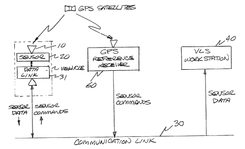
Figure 1 is a block diagram illustrating the=_ primary
components of the GPS vehicle tracking system of the present
invention.
Figure 2 is block diagram of the sensor employed in the
GPs vehicle tracking system of Figure d.
Figure 3 is a block diagram of the RF/zF section of the
sensor of Figure 2.
Figure ~ is a block diagram of the digital signal
processor chip (DSP) of the sensor of Figure 2.
Figure 5 is a flow chart of the process employed to
determine vehicle position using the GPS vehicle tracking
system of Figure 1.
8f
20~~8~~
Detailed Description of the Invention
The present invention is directed to an apparatus and method for
computing the position and velocity of multiple low cost vehicle-mounted
sensors, monitored and tracked by a central control station. In the present
invention, the receiver processor functions are physically separated from the
navigation functions, and a low rate data interface is provided between the
computers that perform these functions. This separation of receiver processor
and navigation functions results in a significant cost saving in the GPS
sensor
that is employed on board each vehicle. The GPS sensor provides GPS satellite
measurements on a periodic basis through a conventional bandwidth radio
communication link to a master station. The GPS sensor data is transmitted on
a
periodic basis at low data rates, thereby permitting the use of conventional
transmission paths capable of handling data at the rate of 300 bits/second.
Thus, data can be transmitted from large numbers of vehicles using
conventional
radio facilities. The master station computes the vehicle position for all
users of the system, and large numbers of vehicle solutions can be processed
simultaneously by the master station by exploiting the commonality in
satellite
geometry for all sensors tracking the same satellites in a common area having
a
radius on the order of 100 kilometers. The master station down loads
initialization data such as initial position estimates or a satellite
selection
table to each sensor on a periodic daily or monthly basis over a conventional
radio communication link. The differential GPS accuracy is achieved for each
sensor by use of a reference GPS receiver located at the master station. The
use of altitude, map, and time aiding at the master station reduces some of
the
satellite geometry requirements, thereby permitting the use of high elevation
9
2~~6~~1
satellites only as a way to simplify satellite acquisition, increase service
availability, and reduce the cost of the antenna system.
Referring now to the block diagram of Figure 1, the vehicle tracking
system of the present invention primarily comprises an antenna 10, a sensor
20,
a communication link 30, a vLS workstation 40, and a GPS reference receiver
60.
Antenna 10 may comprise any of a number of commercially available low-
gain, low-cost antennas, the use of which is made possible as the result of
only
requiring high elevation satellites in the system implementation. This also
simplifies satellite acquisition and permits operation of the vehicle tracking
system in high rise urban areas.
A representative implementation of sensor 20 employs a simplified method
of frequency synthesis, a temperature compensated crystal oscillator (TCXO) 21
or other low cost.oscillator, a simplified digital signal processor (DSP) 22,
and reduced computational processing. Detailed block diagrams of sensor 20 are
shown in Figures 2 and 3. Frequency synthesis within sensor 20 is based on an
oscillator frequency (FO) of 6.1539 MHz that is produced by temperature
compensated crystal oscillator 21. A local oscillator frequency (LO), produced
by local oscillator 23, is 256 X FO = 1575.3984 MHz. The power of 2 multiplier
(256) simplifies the design of a phase lock loop (PLL) 25 that is employed to
lock the frequency of the local oscillator 23 to that of the crystal
oscillator
21. The resulting intermediate frequency (IF) is 1575.42 MHz - 256 FO = 21.6
KHz. This IF is far enough above DC to allow distinction between positive and
negative doppler shifts. It is also close enough to DC to result in minimal
post correlation noise increase due to spectral noise folding. The sampling
clock used by the DSP chip 22 is FO/3 = 2.01513 MHz, a frequency that is ideal
in that it is not related to the 1.023 MBS chip rate. A conventional
microcomputer 24 is used that requires only fixed point operation. Sensor 20
may be configured with from one to eight DSP channels 22, depending on the
particular application. Each of DSP channels 22, the details of which are
illustrated in Figure 4, comprises a custom gate array that performs the C/A
code correlation and removes the L-band signal doppler shift on the digital
GPS
signals. The residual in-phase (I) and quadrature (Q) signals are accumulated
over 1 millisecond for early, late, and prompt code phase and are provided to
a
microcomputer for signal tracking. The tracking microcomputer is used to
select
the GPS satellite to be tracked and to close the code and carrier tracking
loops.
Microcomputer 24 of sensor 20 may comprise any of a number of
commercially available microcomputers, depending on the application and system
requirements. A minimum system configuration requires a Z80 microcomputer or
equivalent to perform signal tracking and to control the operation of sensor
20.
Other applications that involve muitichannel processing and high performance
navigation may require a more powerful microcomputer that may comprise an
existing host system microcomputer, if appropriate.
The details of operation of the digital signal processing chip 22 of
Figure 2 may be understood with reference to the detailed block diagram of
Figure 4. A pair of exclusive OR gates,71 and 72 serve to perform code
correlation on the input signal and also to perform carrier demodulation to
generate the in phase and quadrature signals I and Q. A pair of up/down
counters 76 and 77 serve to accumulate the in phase and quadrature signals I
and
Q. A C/A coder 73 generates coarse acquisition code from input signals G1 and
11
~~~~~v~
G2. G1 is a 10-bit signal received from a memory map interface 74 that
determines which satellite is being tracked. Memory map interface 74 is
coupled
to micro computer 24 of Figure 2 and generates a number of signals from the in
phase and quadrature input signals I and Q. A code phase numerically
controlled
oscillator (NCO) 75 receives a signal TAU from memory map interface 74 that
serves to increment code phase NCO 75 to, in turn, index C/A coder 73. A
carrier NCO 78 is initialized by phase PN and estimate delta phase EDP signals
received from memory map interface 74 and, in turn, generates the in phase I
and
quadrature Q signals used to perform carrier demodulation. Carrier NCO 78 is
clocked by a signal that is 1/30 of the frequency of a DSP clock signal. A 1
ms. interrupt signal INTP is derived from the DSP clock signal and serves to
signal micro computer 24 that data is available.
Data and commands are transferred between sensor 20 and communication
link 30 via a conventional data link 3l capable of handling a data rate of 300
bits per second. Exemplary of the conventional communication links that may be
employed for this purpose are two-way paging systems, private mobile radio,
citizens band radio, cellular radio, personal communications systems, trunked
mobile radio systems, local area mobile radio systems, and military
communications systems.
VLS workstation 40 operates to receive the GPS sensor data through
communication link 30 and to compute the vehicle (sensor ZO) location. The
location is then displayed to the customer superimposed on a map of the
region.
VLS workstation 40 also serves as a communications interface by receiving data
from sensor 20, identifying the vehicle being tracked, and passing the
appropriate data to the navigation function for processing. In addition, VLS
12
~~~6~~~
workstation 40 serves to control sensor 20 by transmitting initialization data
to sensor 20 and by requesting status data therefrom. The initialization data
may comprise a reporting interval, satellite selection, and current position
information. VLS workstation 40 may also serve to compute the position of the
GPS satellites using data from a reference receiver 60. Optionally, VLS
workstation 40 may be employed to derive a DGPS correction factor for the
satellite measurements. It also computes the SV position to provide an
estimated PR or TD measurement to the median location for each GPS satellite
visible from the area of operation. VLS workstation 40 computes an observation
matrix for a median location in the area of operation. This matrix may be
derived from the line of sight vectors to each satellite. A navigation
algorithm is employed to compute the measurement residuals from the data
received from each of the vehicle sensors 20 and the SV correction data. These
measurement residuals are processed by VLS workstation 40 using the data from
the observation matrix computation to derive the vehicle offset from a median
location. Using this approach, accurate vehicle positions may be calculated
over a 100-kilometer area using the navigation algorithm. An aided navigation
solution may be computed by VLS workstation 40 for sensors 20 that report data
from less than four satellites. The vehicle altitude may than be estimated
from
a digital map and used to compute a solution using only three satellites.
Information regarding direction of travel may be included to estimate a
solution
for a short period of time during which data from fewer than three satellites
is
provided. Finally, VLS workstation 40 is operative for visually displaying the
locations of the vehicles on which sensors 20 are positioned to the user. Hard
copy reports that provide this information may also be generated, and this
13
2~~6~31
information may also be integrated with conventional routing software, for
example.
Referring now to the system block diagram of Figure 1 and to the flow
chart of Figure 5, data from sensor 20 is first retrieved from the
communication
link 30 and stored in memory. At steps 2, 13, and 14, the satellite position
is
computed for each satellite in view of the region of coverage as determined
from
the satellite visibility table derived on a periodic (hourly, for example)
basis
from reference receiver 60. At step 3, the satellite positions and clock
calibration coefficients are used to compute the estimated pseudo range (range
and clock bias) to the median location. The line-of-sight vectors are also
determined to this location. At step 4, differential GPS corrections received
from GPS reference receiver 60 are added to the estimated pseudo range to
correct for atmospheric effects and errors in the satellite position and clock
offsets. At step 5, the line-of-sight vectors determined at step 3 are used to
compute a least squares transformation matrix H* for all sets of satellites
tracked by the sensors 20 in the region covered. The measurement residual
vectors are then computed at step 6 by differencing the received measurements
from the estimated measurements derived at step 4. The estimated altitude
offset of the vehicle from the median location is also included as a
measurement
residual. In cases where fewer than three satellite measurements are
available,
data aiding from a knowledge of the vehicle route (direction of travel)
derived
from the digital map 15 may also be included. In order to compute the location
of each of sensors 20 at step 7, the measurement residual vectors derived at
step 6 are then multiplied by the appropriate transformation matrix H* derived
at step 5 to calculate the offset from the median location. If the location
14
derived does not correspond with a possible solution (i.e. does not lie in a
valid region of the digital map 15), the location is recomputed using an
updated
altitude offset and route aiding from the digital map 15. At step 8, the
locations of sensors 20 are displayed to the operator, overlayed on a map of
the
region. Optionally, at step 9, the position of each of sensors 20 may also be
rebroadcast back to a particular sensor through the communication link 30 if
requested at step 11. The position information may be in terms of an offset
coordinate or as a street location derived, at step 10, from the digital map.
At step 12, ULS workstation 70 periodically updates the sensors 20 with
initialization data on satellites to be tracked using information derived from
the visibility table.
While the preferred embodiment of the GPS tracking system of the present
invention has been described above in connection with ground-based vehicles,
it
should be understood that the tracking system of the present invention may be
employed to track sea-based (both surface and underwater) and air-based
vehicles
(e. g. balloons, conventional aircraft, and satellites), as well as personnel,
and even animals, for example.