Note: Descriptions are shown in the official language in which they were submitted.
WO 92/06442 PCI'/US91/07575
,, ~ .
(1) 2070840
AIRPORq~ CONTROL/I~ANAGE:~aT SYSTEM
BAC~CG~t~UND OF l~I}3 INV~TION
One of the major problems facing the world today is
the fact that airplane travel has increased tremendously,
while the airport facilities have not. Attempts to expand
present airports and to build new ones have met with
considerable resistance..... not only because of aesthetic
factors, but also simply because there is now no
inexpensive land adjacent to the large cities.
Because it appears, therefore, dif~icult to meet
--increased air traf f ic demands by increasing airport~
facilities, it is obvious that a solution to the problem
may lie in allowing a given airport to make more intensi~e
use of its facilities. T~e limit to such a solution lies
in the necessity to maintain satisfactory safe~y standards.
Safety plays an important role in the accuracy and limits
of pres~nt day surveillance systems, as well as flight
dynamics for individual aircraft. Te~hnological advances
in aircraft, such as STo~, tilt rotor, and rotary wing,
will enable the Terminal Control Axea (TCA) to handle
increased traf~ic loads without increa~ing the surface
tarmac significantly.
mhe present airport control systems rely heavily on a
radar display screen that ~hows the location of aircraf~ in
flight in a two dimensional format; ~he individual planes
are labelled ~or alti~ude and o~her factors;
unfortunately, much of the worX involves visual observation
through the control tower window and ver~al communication.
Considerable wor~ has been done recently in attempts
to i~pro~e air~ort t~C~ ontrol. The pa~en~ of MUNDRA
No. 4,890,232, for instance, has to do with a visual
display apparatus for showing the relation~hip o~ two
separate aircraft on converging runways. The patent of
' . ' . ' ' ' ' ~ ' .' :., ,., " ' ' .:. ' ' ,' '' ' ',. . ' ' '. ', . . ,: . ': , . ' . ' . ,
.. , .. ''' ' .. ' .''. ,.. "".' :. ,,: . ', : . .' '.: '' , '
W092/~2 PCT/US91/0757~
~Q7~
~2)
GERSTENFELD, No. 4,827,418, describes an expert system ~or
training control op~rators. The patent of GRAHAM et al.,
No. 4,811,230, shows a fligh~ management computer that
includes an interven~ion system. The paten~ of THURMAN,
No. 4,706,198, describes a compu~erized airspace control
system invoking a master control system and regional
control units. A patent to SCHWAB et al., No 4,516,125,
shows apparatus for monitoring vehicle ground movement in
the vicinity of an airport and involves the processing of
radar return video signals. The patent of LOMAX et al.,
No. 4,075,666, shows a magnetic tape recorder for use in
the continuous televising of air traffic control radar.
The patents of VIETOR, Nos. 3,875,379; 3,868-,4g7; and
3,758,765, have to do with terminal airways tra~fic
}5 control, a ground-based computer issues speed commands.
The patent of MAS5A, No. 3,855,571, describes an aircraft
traffic con~rol system invol~ing a sound generator on each
airplane tha~ reaches selected microphones along i~s ground
path, the signals thus received operating on a display
panel in the ~orm of a ~apq A patent of FELL~AN, No.
3,787,056, rela~es to a ga~e device for simulating aircraft
tra~fic control and teaching ~he rules of traf~ic control.
The patent of ~URRJIAN, NoO 3,731,312, has to do with an
air-traffic control utilizing rotating radial signals. In
all of these casesr the airport con~roller lacks suf~icient
in~ormation to handle large amounts of aircra~t landing and
taking off, particularly when mixed with ~ervice vehicles
on the ground. A great deal of the safety of ~hese systems
depends on the visual and verbal information that the
`control personnel picks up and this information is subject,
of course, to the fallibility of the human mind. These and
other difficultie~ experienced with the prior art devices
and systems have been obviated in a novel manner by the
prese~ nvention.
.~
:`
.~ ,
W092/0~2 PCT/US91/07575
(3) 2~70~0
It is, therefore, an outstanding object of the
; irvention to provide a cost-effective airport
control/management system ~or vehicles which are operating
in 3-dimensional space.
Another object of this invention is the provision of
a control/management system, especially for aircraft
control, in which a 3-dimensional display is produced ~o
show the information necessary to operate an airport.
A further objec~ of the present invention is the
provision o~ a means for handling increased traffic at an
airport without.loss of sa~ety.
A still further object o~ the invention is the
provision of a system for superimposing a 3-dimensional
display of local ~ircraft paths on an accurately-configured
map o~ the local space.
It is a further object of the in~ention to provide an
airport traffic control syste~ which will permit an
increase in airport capacity and safety, while allowin~ the
airport to remain wi~hin presen~ territorial boundaries.
. .
Another obj~ct of the inven~ion is the provision of
an improved surveillance system for airport arrival and
departure airGra~t ~eparation.
~nother object of the invention is the provision of an
airport control~management system tha~ is suitable to the
task of providing for increased traffic, while maintaining
sa~ety: that will enjoy a wide and growing market
acceptance with declining life cycle costs; and ~hat will
integrate easily with other pa,~s o the air trarf ic
control and aircraft navigation systems.
' I
,, ,
., , ,. : .,: .,: ": ~ :,
WO9~ 2 . PC~/~S91/07575
~ Q~
; . - (4)
With these and other objects in view, as will ~e
apparent to those skilled in the art, the invention resides
in the com~ination of parts set Porth in the specif ication
and covered by the claims appended hereto.
~ Y Q~_~H~ INVENTION
In general, the present invention has to do with an
airport control~managemen~ system which has a means for
establishing a precise 3-dimensional digital map of a
selec~ed airport space envelope, ~he map containin~ global
positionin~ system reference points. A computer with a
monitor screen is provided ~or receiving and displaying the
` 3-dimensional map. Means is provided that is located on at
least one vehicle in the airport space envelope to receive
continuous global navigation satelli~e system (GNSS)
signals, calculate position, velocity, heading, and time
and transmitting the in~ormation to a receiver associated
with the co~puter. Means is provided within ~he computer
to display a 3-dimensional image corresponding to the
vehicle path on the 3-dimensional map.
.
More specifically, the global navigational satellite
system inc~udes a constellation of space satellites and the
computer contains a pro~ram for manipulating th~ image of
the vehicle path and the map together to a desired apparent
line of observation.
; 25 ~ D~c~IE2IQ~oF-~E~DR~ Gs
The character of the invention, however, may be best
understood by reference to one of its struc~ural ~orms, as
illustrated ~y the accompanying drawings, in which:
, .
: Figure 1 is a generally schematic view of an airport
control/management sys~em incorporating ~he principles o~
the present invention,
:`
~ .
.. '
W092/0~2 PCT/US91/07575
2~708~0
(5)
Figure 2 is a plan view o~ an airport with a vehicle
path impose~, as it appears on a computer screen in the
system,
.
Fi~u-a 3 is â view of the airport and vehicle path as
it appears on the screen wi~h a 20-degrae viewing angle,
Figure 4 is a diagram showing the pattern generated by
the vehicle in take-off mode,
Figure 5 shows a block diayram of a radio-based data
link system which embodies the principles of the present
invention,
.
Figure 6 is a plan view o~ an airport with a
trajectory pa~h, waypoin~s and ~onumented survey points
imposed, as it appears on a computer sereen in the system,
Fisure 7 descri~es the airport terminal system
hard~ re components which e~odies the hardware principles
of the present invention,
Figure 8 desc~ibes ~he airport terminal system
software componen~s which embodies the software principles
of the present invention,
20Figurs 9 de~ribes the aircraft/vehicle system's
hardware components which e~bodies t~e hard~are principles
o~ tha present invention,
Figure 10 describes ~he aircra~t/vehicle system's
: software components which embodies the software principles
, 25 of the present irlvention, and
: , , : . ,, .:.:: .:: . : ~, ,. ..:
- ~ ~ , , . ., . . ::.
W09~0~2 ~ ~ PCT/US91/07575
(6)
Figure ll shows aircraft in 3-D airport map. Aircraft
are 3-D scaled representations of real aircraft. ~ircraft
are drawn into the map from a data base of various aircra~t
types.
D~CRIPTION OF T~_PR~PERR~ BODI~ENT
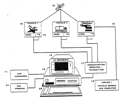
Referring first to Figure l, which best shows the
general features of the invention, the airport
control/management system, indicated generally by ~he
re~erence numeral lO, is shown as including a map generator
ll for establishing a precise 3-dimensional digital map of
a selected airport space envelope. The map contains global ~-
positioning system reference points. The sys~em includes
a co~puter 12 having a monitor 13 with screen 14. The
computer and screen serve to receive and display the 3- ;
dimensional map.
A GNSS receiver 15 is located in a vehicle 16 (#l),
which is loeated in ~he airport space envelope. The SNSS
rec~iver calculates the position, velocity, time and
heading, possibly using referen~e station corrections.
,~ 20 Thesè signals are trans~itted to a receiver 17 which, in
~- turn, is connected to the Co~pu~r 12. The co~puter
~, contains a program to use ~he said signals to superimpose
~ a 3-dimensional image corresponding ~o the vehicle path
;~ onto the ~-dimension~l m p.
. ~ ,
' 25 Tha GNSS receiver incorporated in ~he vehicles
contains, in the usual way, access to space satellites 18.
The computer 12 contains a co~pu~er-aide~-drawing (CAD)
~-~ program 24 that is capable of manipulat.ing the image of the
vehicle path and the ~ap to a desired apparent point of
observation. A secondary screen '9 may be provi~ed at a
suit ~ le airline facility, to show the location and
~` ~ovement o~ the airline's own vehicle (#3, for instance).
...... . _
W092/0~2 , PCT/U591/07575
2~708~0
(7)
Figure 2 shows the image 21 as it appears on the
monitor screen 14 when the 3-dimensional map 22 of the
airport (generated by the generator 11) has the path 23 of
a vehicle, such as vehicle #1, imposed upon it. This is a
plan view in whlch th2 airport map is shown as it appears
from directly above and as the vehicle path appears from
the same vantage point. The term "airport" can, of course,
include not only conventional land-based airports, but also
vertiports, heliports, and sea bases.
Figure 3 shows the appearance of the screen 14 when
tha computer aided drawing program 24 is used ~o rotate the
image to an aspect which is 20 degrees out of the-
horizontal. In ~oth Figures 2 and 3, the vehicle is shown
in the taxi to take-o~f mode, but, of coursP, ~.h~
appearance would be somewhat similar if .it were in t.he
landing ~ode.
The operation and advantages o~ the invention ~ill now
be readily understood in view of the above description.
The method of est.~blishment of a pre~ise 3-dimensional
digital map 22 is well-knawn and makes use of
photogrammetry and stereoscopic digitalization techniques.
The digital information contained in the ~ap generator 11
is then applied ~hrough the computer 12 to ~he scre~n 14.
At that ti~e, the map 22 appears on the screen and ~he
resulting i~age can be ~anipulated by use o~ the cumputer-
aided drawing program 24 to show the appearance o~ the
airport space envelope as i~ appears ~rom any deæired angle
and at any distance. This manipulation is controlled by
means of a keyboard 20, other standard input device, such
as a mouse or tablet, or re~ident applic~kions software.
The nex~ step consists Q~ rec~ vins GNSS signals,
using an antenna designed ~or thiS purpose. The on-board
receiYer on ~he aircraft 16 per~orms the necessary
calculations and then transmit the results. using a
'; . . ' ' " "`, ; ;' .'
wos2/o~2 49 PCT/USg1/07575
(8)
transmitter 15 within the vehicle. The equipment makes use
of satellites 18 whose position relative ~o the earth's
center of mass is precisely known. The transmitter 15
sends information as ~o the aircraft's location, speed,
heading; identi~i zativn and time o~ transmission to the
receiver 17 and this is presented to the computer 12 for
display on the screen 14. The information thu~ transmitted
generates an image 21 on the screen which represents a
three-dimensional picture of the vehicle path 23
superimposed on the map 22. The image 2~ thus produced can
be rotated by the CAD program 24 to any desired angle and
200med to enlarge or decrease the size.
.
Figure 2 shows the appearance of the image 21 in plan,
i.e., as the airport and aircraft path appear when viewed
15 from directly above. ~igure 3 shows ~he image when the ,~
observation angle is 20 degrees above the horizontal. It
can be seen, ~hen, tha~ an accurate visualiza~ion of the
vehicle's progreSS iS made possi~le by selecting various
angles of view, as desired. For in~ance, the chart o~
Figure ~ shows a typical elevation pro~ile o~ an aircraft
as it mo~es a~out the airport prepara~ory to taking off and
then as it takes orf. ~he image 21 can, of Course, be
transmitted and displayed on other screens: for instance,
the screen 19 is located in the ~acilities of an airline
whose vehicle #3 is within the airport space en~elope.
Since ~hst airline may only be interested in its own
vehicle, their screen image may show only ~hat vehicle, or,
if desired, may show the same complete image (with other
vehicles that is sho~n on the main screen 14). Similarly,
the image 21 can also ~e displayed on a screen in ~he
aircra~t or other airport vehicle. Again, the screen image
may show only that vehicle or, if desired, the same or
another image that is shown on ~he main screen 14.
., , :
~ - . ~ .... .. .
PCT/US91/0757
W092~0~2
(9) 20708~0
It can be seen, then, that the present inventive
system provides an integrated airport planning and design
tool. It incorporates available technologies of the type
that will play an impor~ant future role in aviation
naviga~ion and air traffic control.
Air transporta~ion is expected to grow a~ a large rate
in the next few years. The predicted growth will place a
substantial load on existing airports. Present airports
will need ~o be ~odernized to support such growth.
Building new runways and buildings is expensive and
sometime difficult politically. A better ~ethod of
improving airport capacity and safety may be from improved
automation and modernization. Automation and modernization
can be a viable me~hod of increasing capacity and safety,
while the airports remain within present territorial
boundaries.
The present inVen~ion, therefor~, serves to satis~y
three primary objectives. T~e three objec~ives are: (a)
suitability for the task, (b) a wide market acceptance with
declinin~ e cycle co~tS, and (C) ability to integra~e
~asily wi~h other parts of the air traffic control and
aircraft navigation syst~ms.
In a practical em~odiment o~ the invention, the
computer used was a personal computer with 3-D graphics.
It was based on a 3~6 chip operating at 33 MHZ with a 12
~B, 80 NS RAM and~387 co-processor. ~he global position
system was the NAVSTAR GPS utilizing earth centered, eart~
~ix (ECEF) coordinates and using the ECEF world geological
survey (WGS-84) which was ellipsoid-adjusted for geoid
separation. The separation was -28.3 meters mean sea level
(~SL) elevation a~ Manches~er, N.H. a~d used in ~ 3-~ map
converted between latitude/longitude and N.H. state plane
and other coordinates. The comput~r used the NSDOS
operating sys~em or 9CV XENIX OS operating system with
. . . ~. . ~ . ..... . . . .
W092/0~2 PCT/USgltO7575
~,~10Q3.4~, ;, (10)
mode~n capability.
In addition to the basic syst~m described abov~, a
great many other features can be added to the system of 3-
~airport maps for air ~raf ic ~r.trol and navig~' ion.
Another f eature of the system involves having the
airport map arranged in layers for target sorting and
tracking. Each layer could be specifi~d for particular
function such as air traf ic control, airline or airpor~
operations. The syst~m operator could selec:t one or more
layers to be displhyed . In this way, only inf ormation
relevant to his present function would be displayed.
Another feature of the system involves the use of
precise multi-monumented survey points in airport area f or
local coordinate conversions and real ~ime map displays.
. Another feature o~ the system is the concept of
forbidden zones (areas off limits) based on latest notice
t~ air~en information (notams). These zones are ~reated in
the map data base, then u~ed in naviga~ional algorithms.
Warnings are generated to ~h~ pilot and~cr the air tra~fic
controller when the airplane is in or approaching a zone.
A for~idden zone oan be around two potentially colliding
aircraft.
Anoth~r feature of ~ne system is ~he use o~ a digital
data link ~or automatic dependent surveillance (ADS-radar
free surveillance) in the ter~inal controller area. The
syste~ pref~rably uses X.2~ ca~rier sense mul~iple access
(CSMA) digital communications using frequency diwision
multiplexing (FDM). ~his technique uses the existing ~HF
a~ronautical SDectrum or other available RF spectrum.
The data radios u~ed in the practical e~kodiment of
the invention featurQd 25 kilohertz channel spacing versus
.., . , .:
.- :, .,:
W092/0~2 ~ PCT/US91/~7575
2070841~
(1~)
the 50 kilohertz spacing still in use today. Recently the
Federal Communication Commission (FCC) delayed the date
when 25 KHz channel spacing will be required for all
aviation users until 1997. The aeronautical YHF band
oper~eS at ~r~yuencies rom 118 MHz ~o 136.975 MHz, giving
a total of 760 channels based on 25 KHz channel spacing.
Since spectrum is not infinite, sensible use is necessary.
The following model is used to provide insigh~ into
possible system capacity and operational tradeoffs. The
model uses data for the New York Metroplex and southern New
Hampshire area.
DATA LINR ASSUMPTIONS
1. Traffic control area air and ground targets transmit
position to tower air traf~ic controller.
~. The data link is full duplex ov~r two channels, to and
from the aircraft and con~rol tower air traf~ic
control facility.
`
3. Non-~oving aircraft will report positions only once
- per minu~e or upon tcwer interrogation.
4. Moving air~ra~t will broadcast position once per
second on approach and departure o~herwise eve~y two
seconds or upon interrogation.
.
5. UsP of voice communications will be minimized and
restrictad to use on selected channels.
6. Radio frequen~y transmission rate is ~ypically 4800
baud.
7. Carrier Sense Multiple Access X.25 transmiesion
connection, error detection overhead and packet
collisions reduce effective RF bw to 1200 baud.
:: . - , ',: .,' , : ' . :' .~ :,: ':::':, : ' ' ' . ' :: ' : . ' ' ' :. "
: -': ' ': -,' . . :
~Q~ o~ PCT/USsl/07s7s
(12) :~
8. Frequency agile (scanning) radios are used with 760
channe 1 s .
9. Selected channels are dedicated to tower broadcasts
(ATIS, interrogatlon, differential correctisns, etc.).
10. During data collisions, the "capture effect" will
allow the strongest transmission to get through,
naturally filtering out unwanted signals from aircraft :~
far outside the traffic control area.
11. If a particular channel is satura~ed, the ADS message
handler automatically retransmits-on another available ~- ~~~
channel.
~2. Integrity iS handl~d in the ~PS receiver wi~h one of
the developing techniques.
13. Time of tr~nsmissionO
Each aircraft broadcasts its ADS message as d~fined above.
The message consists of the following data
ATC system is based on ECEF positions, only maps are in
surfac~ coordinates.
,:
W092/0~2 : PCT/US91/07575
2070840
(13)
TyPIC~L MESSAGE
ID# 8 Characters
Current Position:
ECEF X Position (M) 10 Characters
5 ECEF Y Posi~ion (M) 10 Characters
ECEF Z Position (M) 10 Characters ~.
ECEF X2 Position (M)2 Characters *
ECEF Y2 Position (M)2 Characters * . r
ECEF Z2 Position (M)2 Characters *
10 ECEF X3 Position (M)2 Characters *
ECEF Y3 Positlon (M)2 Characters * - -
ECEF Z3 Posltion (M)2 Characters *
ECEF X Velocity (M/S)4 Characters
E`CEF Y Velocity (M/S)4 Characters
15 ECEF Z Velocity (M/S)4 Characters
~ext waypoint (where headed information)~
~CEF X 10 Characters
ECEF Y 10 Characters
ECEF Z 10 Characters
20 Time6 Characters (hhm~ss)
Total Characters/Nessage98 Characters
.
T~e asterisks identify optional fields ~or designating and
determining vehicle attitude in 3-D digital map data base.
Figure 5 shows a blork diagram of a radio-based data
link system which e~bodies the principles of the present
invention. As described above, in thi~ bi-direotional
communication syste~, each airplane ~ries ~o get. a
conn~ction on a particular c~annel, usinq ~he X.25
protocol~ If an airplane is ~nable to use that channel
within a predefined p~rlod of ti~e, the airplane tries
, ~ . , , ,; , "
WO 92/0M42 ~ Q~ S P~/US91/07575
(1~)
another randomly sel~cted channel (FDM). This technique
maximizes us~ of the available radio frequency spectrum and ;~
autom,tirally ad~usts to tra~fic load.
AnethQr . a tur2 of the ~ystem is use of carrier sense
5 multiple access bi-directional data link f or tower to
aircra~t communication.
Another f eature of . the system is use of earth
cen~ered, earth f ixed ( ECEF ) navigation on the airport
surface, and in th~ term,inal airspace .
An,other feature.of the system is use of three GPS ~~
antennas to determine aircraft attitude. Attitude of
aircraft is then used to draw the aircra~t in the 3-D
digital map with the proper attitude. Antennas are placed
at three known poæitions on the aircraft. The GPS
positions are tAen u~ed ~s handles ~o draw the airrraft
into the 3-D map.
Another feature of the system is that the data link
supports three ECEF positions in the data message, so the
airplane can be shuwn at ~he proper attitude in the 3-D
airport map presen~ation. Th~refore, ~his information i5
provided in the data link m~ssage.
Another feature of th~ system is automatic ~ependent
surveillance (ADS) transmission broa~cast rate which is
programmed to the phase of flight. Thus, the data transfer
rate varies, depending on the data rate ne2ded ~or the
airplane's present activity. For example, an air¢raft
whic~ is not moving or is not occupied would transmit once
every 60 ssconds, an aircraft which is taxiing would
transmit every 2 seconds, and an aircraft which is on
approach or departure would transmit every second. This
maximizes available bandwidth of aeronautical spectrum
because each airplane would trans~it at a minimum rate
.
wo 92/064~2 Pcr/US91/07575
20~840
(15)
which is required at that phase o its f light . Reporting
rates may be easily mo~ified as conditions warrant .
Ano~her feature of the system is the construction o~
a po~ition keyed data base which maintains th~ last
position an aircraft reported. When a plane taxis to a
parking location, the data base maintains ~he plane's
position when and after the aircraft is turned off. When
the plane is us~d again and star~s to move, the data base
is updated with new position data. In this manner, the
data base will be self loading and will eventually contain
all aircraft in the airport. This concept is extsnsible to
airport surface vehicles such-as fuel trucks and buses. -~~~
Another feature o~ the system is the use of precise
velocity and acceleration information, deri~able from GNSS
S naYigation and position in~ormation, as inputs into
collision projection algorithms based on ~he earth
centered, earth ~ixed re~erence.
~ nother ~eature of the sy~tem is th~ use of a multi-
windowed display ~howing differen~ sec~ions or views of the
airport in each window.
Another feature of the system is the ability to use
map layers and zones of the map to segregate info~mation
into various air traffic controllers' stations.
Another feature of the system is the use o~ a position
Xeyed aircra~t data base to automatically filter aircraft.
This would be performed using GP5 position, the ADS data
link, and the ground compu~er data base.
A~other f2ature of the sys~em is man-machin~ inter~ace
capability in which the controller defines a departure
and/or approach trajec~ory (air and sur~ace) using ~.he data
entry device and 3-~ airport map, or calls up a previously
W092~0~2 ~Q~ o~ 40 PCTtUS91/0757; ;-
~ i (16)
defined trajectory. The path contains waypoints, notam
data and forbidden zone in~ormation. The information is
drawn into the map and then waypoints are passed to the
aircraft as part of ATC clearance. The air traf~ic control
system matches the pres~nt position and the next on-board
waypoint with stored trajectory data in air traffic control
computer. An alarm is sounded if a preset ~hreshold or
deviation is exceeded, meaning the aircraft is off course.
urth~r disclosure: FIGS. 6-lO.
Figure 6 shows the appearance of the screen 14 when a
trajectory path 24,-waypoints 25 and monumented survey
poin~s 26 are imposed on the digital map. In Figure 6, the
trajectory path is shown for a ~axiing maneuv~r, but, of
course, the appearance would be somewha~ similar for other
taxi maneuvers as well as take off and landing
trajectories. Figure 6 also sho~s the appearance of the
screen 14 when a forbidden zone 27 is imposed on the
digital map.
Figure 7 shsws the major hardware components of the
airport terminal control system~ For each vehicle 28
equipped with a GNSS receiver and tran~it~er, a GNSS
message is tran mitted via the vehicle's radio ~quip~ent 29
through the com~unication interface 30 to the ATC computer
32. The signals may include di~erential correc~ions
broadcast by a differential base ~tation 3~. The computer
operator has access to a variety of dat~ entry devices 33
including, but not li~ited to, a keyboard 35, mouse,
spaceball or ~rackball 36 to control the presentation on
the co~puter display screen 34.
:: -~ . .: .: .- . ............. ... . ..... .. ...
: ... . , ~ :
W092/0~2 , PCr/US~1/07575
207~0
(17)
Figure 8 shows the major software components of the
airport terminal control system. The GNSS signals
broadcast by the vehicles 37 and the differential
corrections determined ~y the differential GNSS so~tware 39
are proce3sed by tne Real Time Communication Handler 38 and
sent to the ATC Processor 40. The ATC Processor uses the
GNSS data to perform the following processing functions
list~d under item 41: projections, coordinate conversions,
zone detection, layer f ilter, view control, alarm control
ancl display updates. The ~TC Processor sotware 40 also
receives inputs from the Controller Inter~ace 43 software.
The Controller Interface uses the data received by the
controller's inputs 44 to compose ATC commands which are
sent to the ATC Processor 40 for processing. Commands
a~ecting the presentation on the computer display screen
3~ ar~ sent by either the ATC Processor 40 or Controller
Interface 43 to the Graphical Con~rol 42 software. Bo~h
the ATC Processor and Graphical Control 42 so~t~are use the
~onumentation, NOTAMS, Tra~ectories, AircraftfVehicle,
Airport Map, ATI5 Interface and Airport Status da~ bases
45 to manipulate the presentation on the computer display
screen 14.
Figure g shows the major hardware components of the
aircra~t-vehicle system. The Aircraft Co~puter 52 receives
GNSS data from the on~-board GNSS r~ceiver 51 and,
optionally, from other vehicles 48 through its radio 49 and
communications interface device 507 Messages are received
from th~ A~C Tower 47 through the same communication~ pa~h.
Differential correction broadcasts are received through the
radio equip~ent 49 and communication interface 50 to the
GNSS receiver 51 where ~hey are processed internally and
then passed to the Aircra~t Computer 5Z. The operator has
access tQ the on-board data entry and display devices 53
including, but not limi~ed to, a keypad 55, mouse and a
display screen 54.
. . . .
PCT/US91/07575
(18)
Figure lO shows the major software components of the
aircraft-vehicle system. The GNSS signals broadcast by
other vehicles 5~7 (optional), the di~ferential correction
broadcasts 58 and ATC messages 59 sent from the tower or
e r~mote station are processed by the Real Time Communication
Handler 59 and sent to the Aircraft Processor 61. GNSS
messages from the on-board GNSS receiver 60 are also
received by the Aircraft Processor 61. The Aircraft
Processor uses both ~he remote and on-board GNSS data to
perform the ~ollowing processing functions liste~ under
item 62: projections, coordinate conversions, zone
dete~tion, layer filter, view control, alarm control and
display updates. ATC co~ma~ds are processed ~pon receipt
from the Real Time Communication Handler 59. Display
updates to the airline/vehicle screen l9 are passed ~ro~
the Aircraft Processor 61 so~tware to the Graphical Control
60 softw~re. ~oth the Aircraft Processor 61 and Graphical
Control 63 so~tware use ~he ~onumenta~ion, NOTA~S,
Trajectories, Aircraft/Vehicle, Airport Map, ATIS Interface
and Airport Status data bases 64 to manipulate the
presentation on the computer display screen l9.
,
Figure ll shows aircraft in 3-D airport map. Aircra~t
a~e 3-D scaled represen~ations of real aircraft. Aircra~t
are drawn into the map from a data base of various aircraft
types.
It is obvious that minor changes may be made in the
form and construction o~ the invention wi~hout departing
from ~he material spirit thereof. It is not, however,
desired to con~ine the i~vention to the exact ~orm herein
shown and described, but it is desired to include all such
as properly come within the scope clai~ed.
The invention having been thus descrihed, what is
claimed as new and de~ired to ~ecure by Letters Patent is:
,
, ,",' ~ , , ~, ,:;,; ,; ~,;.,"":,"", ,' ",; . ,, ,~:; ,. ... . .