Note: Descriptions are shown in the official language in which they were submitted.
WO91/19210 PCT/AU91/00238
- 1 - 2~6~
-
SUB-AUDIO MAGNETICS INSTRUMENT
BACK&ROUND ART
This invention relates to methods and apparatus for
geophysical exploration and other subterranean
investigations. More particularly, it relates to an
apparatus with which magnetic anomalies of temporal-and
spatial origin may be measured simultaneously and
conveniently distinguished. The apparatus enables several
electrical and magnetic parameters of the ground to be
determined and mapped in the one operation and with the
one sensing device. The speed with which this apparatus
can obtain each measurement is such that it has now become
practical to routinely record measurements at intervals of
a metre or less and by so doing achieve exceedingly high
definition in near surface geophysical investigation.
Such information can be useful in geological mapping, and
in the location of such things as mineral deposits,
groundwater and petroleum and buried artificial items such
as pipe-lines, explosive ordnance, archaeologically
valuable material and the like.
Geophysical exploration methods involve the
measurement of physical properties which vary in a manner
which is related to changes in the composition and
structure of the ground in the area of investigation.
Such properties include, density, magnetic susceptibility
and remanence, seismic velocity, electrical conductivity
and polarizability and many more. Geophysical literature
describes various apparatus for individually measuring
these parameters. Two families of these physical
properties are commonly measured in geophysical
exploration methods. These are:
1. Magnetic Properties
The earth's magnetic field varies both in space and
time. It is well established in the prior art to make use
of this magnetic field in a number of ways for geophysical
W091/19210 PCT/AU9ltO0238
investigations. For example, magnetic detectors have been
most commonly used to determine the magnitude of the
earth's magnetic field at a number of points within a
survey area. The spatial variation in the earth's
magnetic field over the area surveyed can be isolated by
subtracting from each measurement the value of the
magnetic field measured simultaneously at a nearby,
stationary reference point. The spatial variation in the
magnetic field are quantitatively related to changes in
the magnetic properties of the ground.
2. Electrical and Electromagnetic Properties
Electrical resistivity, electromagnetic and induced
polarization mapping have been described in many articles
to be found in geophysical literature. With each of these
methods, an electric current is created in the ground from
artificial galvanic or inductive sources, or by natural
means. The flow of current will behave according to
established electrical and electromagnetic rules. For
example, it will preferentially flow through material that
is of more conductive composition, and if the introduced
current is of alternating polarity, then the current flow
also obeys a frequency-depth relationship. It is also
known that by creating an artificial current in the
ground, a polarization effect may occur to a varying
degree depending upon the composition of the material
present and the frequency-depth relationship.
Various artificial energising current waveforms and
frequencies may be used for different effects. Point by
point measurement of the potential between electrodes
placed in contact with the ground, and measurement of the
secondary electro-magnetic field due to the current in the
ground, and measurement of the phase between the
transmitted~waveform and the received signal have all been
previously used, either individually or in combination, to
map the subterranean electrical properties.
WO91/19210 PCT/AU91/00238
3 2~84~
.._
Galvanic measurements have of necessity been made
point by point where electrodes were located in the
ground. Consideration was required of the geometry of the
electrode array. Limitations associated with the use of
electrodes are avoided by applying inductive sources to
generate the required currents in the ground. Individual
components of the secondary electro-magnetic field arising
from the flow of current in the ground are then commonly
measured with induction coil type receivers. When
inductive sources and receivers were employed, the method
could be adapted to moving, marine or airborne
applications. The use of inductive techniques required
that consideration be given to the orientation of the
transmitter and receiver.
DISCLOSURE OF INVENTION
In this invention, apparatus using a single
transducer has been designed to measure several
parameters, relating to magnetic, electrical or
electromagnetic properties of the ground, simultaneously
with inherent savings in cost, time and complexity.
The foregoing magnetic, electrical and
electromagnetic properties may be simultaneously
investigated by the apparatus specified by this patent.
Broadly speaking, this invention can be described as
a means or method for subterranean investigation wherein
spatially varying magnetic or electromagnetic fields are
determined by traversing a survey area with a magnetic
detector at a predetermined approximately constant
detector height at traversing speeds not exceeding a
predetermined maximum speed and by measuring the magnetic
or electromagnetic temporal signals comprising frequencies
less than or equal to a high frequency cut off determined
by the traversing speed and detector height.
In the present invention spatial magnetic anomalies
are measured as a temporal signal by simply traversing a
. - .
~ 0 8 4 6 5 6
survey area. Positional information is obtained from an in-
built odometer or alternative positioning device. It has
been found that this temporal signal obtained from a moving
magnetic sensor has a high frequency cut off which is
related to the elevation of the sensor above ground and the
speed at which it is moving.
Consider a magnetic detector that is operated at an
approximately constant elevation E (measured in meters)
above the ground surface, and moved at a maximum speed S
(measured in meters per second). The inventors have
determined that the low pass cut off frequency F (measured
in Hertz) in the magnetic field of spatial origin will be
given approximately by the relationship.
F = S/2E Equation 1.
Thus, the temporal signal from a magnetic sensor
traversing at 2 m/sec at an elevation of 1 m above ground,
will have a 20 db cut off at less than or about lHz.
Natural occurring temporal changes in the magnetic
field below this frequency may conveniently be removed by
reference to a synchronized, stationary magnetic sensor.
Thus, in one preferred form, the invention
additionally includes steps of the method, or additional
means, for simultaneously obtaining a measure of earth
magnetic field temporal changes from a synchronised,
stationary magnetic sensor, and subtracting same from the
measured signals.
Artifically induced magnetic fields generated by an
inductive or galvanic source, or a combination or both, may
be simultaneously measured with a suitable magnetic sensor.
The signal due to spatial sources in the ground may be
conveniently filtered from that due to the artificial source
provided that the artificial signal is restricted to
frequencies greater than F, the highest frequency in the
signal of spatial origin.
Low pass fitered data are resampled at regular
distances determined by the positioning device and
,~ ,,
WO91/19210 PCT/AU91/00238
'~ ~2~8~6
selected to properly sample the spatial magnetic field
according to sampling theory. Commonly the interval will
be approximately equal to the sensor elevation. The
resampled data is recorded.
The high pass filtered data are spectrum analysed and
relevant parameters of the spectrum also recorded at
regular distance intervals. Relevant parameters commonly
include the amplitude and phase at each of the component
frequencies present in the artificially generated
electromagnetic field.
The recorded spatial magnetic field and spectral
parameters of the secondary electromagnetic field may be
later analysed by the survey expert to produce the desired
magnetic and electrical mapping of the survey area.
A suitable magnetic sensor must meet the required
specifications of sensitivity and frequency response in
order to detect magnetic field changes in the band from DC
to the maximum frequency in the artificially induced
signal.
A useful sensor for such measurements is an optically
pumped device which will resonate at a frequency dependant
upon the magnitude of the ambient magnetic field. Within
limits, the operation of this type of sensor, is
independent of orientation, thus avoiding a common
restriction in the operation of previously used
electromagnetic detectors.
By way of example only, one preferred form of the
invention will now be described with reference to the
accompanying drawings in which:
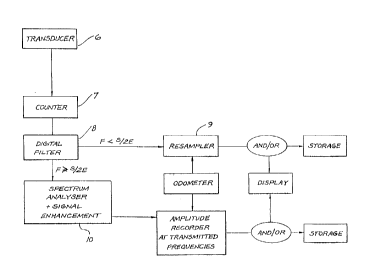
Fig. 1 is a flow chart indicating the mode of
operation of an embodiment of the invention; and
Fig. 2 is a plan sketch of a survey area in which a
method of the invention may be affected.
An area to be surveyed 1, perhaps several square km
is size, is firstly prepared by setting up an appropriate
WO91/19210 PCT/AU91/00238
- 6
""~ 2~g4~56
transmitter 2. The transmitter 2 may comprise a direct,
galvanic type transmitter 2a, having a power source and
electric waveform generator 3 and electrodes 4, or an
induction type transmitter 2b including an induction coil
or antenna and associated power source and waveform
generator 3. In either case, the waveform transmitted
must contain frequencies constrained to the range between
F defined in equation l and the maximum frequency response
of the digital magnetometer. A combination of both
transmitter types operating at different wavefor~
frequencies within the above defined band, may also be
used to advantage in some situations. For convenience,
preselected traverse lines forming a suitable network
covering the survey area l are indicated to the personnel
carrying out the survey work.
A magnetic field transducer 6, conveniently
comprising of an optically pumped type magnetic resonance
device, is transported by hand or by self propelled
vehicle at a substantially constant elevation along the
predetermined traverse lines. Meanwhile, an accurate
odometer device, such as of cotton thread or radio type,
accurately provides positional information of the
transducer.
The signal from the transducer 6 is processed by a
counter 7 and transformed into a digital signal
representing the real time detected magnetic field
intensity. Such signal is then filtered by a digital
filter 8 into high frequency and low frequency
components. The separation frequency F of the filter 8
will have already been selected according to equation l
when the maximum traverse speed and sensor elevation
combination were defined.
The low frequency components corresponding to spatial
anomalies are resampled at 9 at regular position
increments which should not exceed the elevation of the
WO91/19210 PCT/AU91/00238
2~84~
'',~,.,
sensor above the ground. The time at which measurements
are made is also recorded so that natural temporal
variations in the earth's magnetic field as recorded from
a synchronized stationary reference magnetometer can be
subtracted at a later stage.
The high frequency components corresponding to the
secondary electromagnetic field associated with the
current driven through the ground by the transmitter, is
digitally processed at 10 including signal enhancement
techniques and spectrum analysis. Again, at regular
distance increments, the amplitudes of each of the
transmitted frequencies is produced for storage (and later
use) and immediate readout. When mapping certain sub soil
properties it is desirable to obtain a measure of any
phase shift between the original and detected signals. A
radio timing link or similar synchronising device, can
therefore be included and complex spectrum analysis used
in processing the digital signal. The phase information
at each of the transmitted signal frequencies is then
recorded together with the amplitude information.
Also, for instantaneous benefit of the person
conducting the measurements, a real-time visual display
can be provided in any predetermined desirable form such
as graph or digital read-out.
Thus the information produced and optionally stored
allows the survey expert to produce a magnetic field,
electrical conductivity or other mapping of the survey
area in the already well established manner. However, it
is now possible to gather this varied information with a
single transducer, at a very much greater rate, and
therefore at a very much lower expense. Where it was
previously often necessary to carry out a large number of
individual measurements using different instruments, and
record each of those measurements before moving on to the
next measurement point, it is now possible to traverse the
WO91/19210 PCT/AU91/00238
2~8'1~6
survey area quickly while continuously measuring,
analysing and recording all of the necessary information
with the one instrument.
While the speed of traversal is in part limited by
S the frequency response of the magnetic detector and the
power of the digital processing equipment, available
technology allows traverse speeds in the order of 10 km/h
with a sensor elevation and a measurement interval of 1 m.