Note: Descriptions are shown in the official language in which they were submitted.
2095~62
VARIAB~E RATF APPLICATION 8Y~TEM
BACKGROUND OF THE INVENTION
I. Field of the Invention
The present invention relates generally to applying
fertilizer to agricultural land, and more particularly to
a method and apparatus for custom applying several types of
fertilizer blends to specified locations in a field.
II. Bac~ground of the Invention
Agricultural lands are typically comprised of several
different soil types, each of which may be categorized
according to the relative proportions of sand, clay and
silt it contains. A typical agricultural field is usually
fertilized with more than one blend of fertilizer, wherein
the different soils and/or soil types absorb, release and
otherwise react with the various fertilizer blends at
differing rates. These differing rates depend upon the
soil type, and upon the nutrient components present in the
specific types of fertilizers. The three most common
nutrient components present in fertilizer blends comprise
a nitrogen, phosphorous and potash. During a typical
application of nitrogen, for instance, applying 50 pounds
per acre will increase the field nitrogen level by 2%.
However, this level of nitrogen can vary depending on the
soil type and upon the application of a second and
different blend of fertilizer. For instance, if applying
50 pounds per acre of phosphorous would increase the field
phosphorous level by 2%, then the level of previously
applied nitrogen may have a modified level due to the
subsequent application of phosphorous the characteristics
of the particular soil type, and the resultant interaction
of the nutrient components. Thus, the calculations become
rather complex when more than one type of fertilizer blend
is added to a particular soil type. Further, since there
may be several different types of soil encountered during
the application of the fertilizer blends, the calculations
can become even more complex. *
209~462
_ 2
Studies have been undertaken to quantify the effects
of various different fertilizer blends applied in various
combinations to different types of soil. Thus, a rather
detailed data table or chart is available accounting for
the various possibilities of different fertilizer blends
combined and applied to different types of soil. Further,
effects of sun, wind, and water drainage can also be
considered to characterize the fertilizer levels over time
based on the topography of the field.
Due to the unique soil distribution and topography of
each field, a farmer's task becomes difficult when trying
to custom apply a certain quantity of a certain fertilizer
to certain areas of the field. Given the desirability of
utilizing a large dispensing apparatus to a tractor the
various soil conditions and topography encountered during
sllort periods of use can change quickly, since they are not
uniformly patterned. Thus, it is not possible or practical
for the farmer using conventional apparatus to attempt to
reactively alter the dispensing rate of a particular
fertilizer or nutrient component in a fertilizer blend as
a tractor traverses the field. Rather, with
conventional apparatus, a farmer typically averages soil
characteristics of a given portion of the field and applies
a predetermined ~uantity of each fertilizer upon that
portion of the field. Thus, while the predetermined
quantity of a known blend of fertilizer components may be
ideally suited for some portions of the land, the certain
percentage of one nutrient component in of a blend
fertilizer may be too high for some portions while a
certain percentage of another is too low for another
portion of land.
U.S. Patent 4,630,773 to Ortlip teaches a method and
apparatus for spreading fertilizer including a single
digital map of the various soil types in a field to be
fertilized. This map is normally ascertained from an
aerial infrared photograph such that various portions of
the land are categorized. The apparatus includes pixels
20~5462
; -3-
arranged along an x-y locator and wherein the apparatus
dispenses a certain percentage of a blend of fertilizers
depending upon the location of the dispensing apparatus in
the field according to the digital soil map. While this
apparatus accounts for the changes of soil types throughout
the field, it may not to account for the interactive
effects of multiple fertilizers applied to different soil
types. Further, the Ortlip apparatus does not consider the
effects of fertilizer levels upon a field having varying
characteristics due to a varying topography and existing
fertilizer levels.
OBJBCT8
It is accordingly a principle object of the present
invention to provide a variable rate application apparatus
capable of dispensing an appropriate amount of a single
fertilizer based on the soil type at each particular
location of a field to attain predetermined fertilizer
levels. These levels can be determined from predefined
characteristics, such as existing fertilizer levels, field
topography or drainage studies.
It is a further object of the present invention to
provide a variable rate application system capable of
dispensing several different types of fertilizers and which
takes into account the interaction between the several
fertilizers.
It is a further object of the present invention to
provide an apparatus which can calculate the appropriate
application dispensing settings of the various fertilizers
upon a given soil type to achieve the desired fertilizer
levels.
It is a further object of the present invention to
provide a feedback arrangement to sample and quantify the
soil of a field to characterize the field.
It is a further object of the present invention to
provide a fertilizer level sensing feature for
characterizing and mapping present fertilizer levels of the
field to be fertilized.
. .
~ 2095462
Other and further objects of the present invention
will become apparent to those skilled in the art upon a
study of the following specification, pending claims and
accompany drawings, like numbered references correspond to
like elements.
SUNMARY OF THE INVENTION
The foregoing features and objects are achieved by
providing a variable rate application system having a first
digital map characterizing the soil types, a plurality of
second maps characterizing the desired level of various
fertilizer types upon the field, and including a processing
means to calculate and control the dispensing rates of the
various fertilizers based on both the soil map and
fertilizer maps. The application system comprises a
vehicle 11 including a first product bin for holding the
first fertilizer to be applied to the field to be
fertilized. A dispenser is mounted on the vehicle 11 and
operates in response to a first dispenser control signal
for dispensing the first fertilizer at a selected
dispensing rate from the first fertilizer bin. A conveying
and spreading mechanism is mounted on the vehicle 11 for
conveying the first fertilizer dispensed from the first bin
via the dispenser over the ground. A controller is
operatively connected to the dispenser for generating the
first control signal to control the rate of dispensing the
first fertilizer. The controller includes a digital soil
map for storing and indicating a distribution of different
soil types in the field to be fertilized. The controller
further comprises a first fertilizer map partitioned into
pixels or boundaries for storing and indicating a desired
distribution level of the first fertilizer in the field to
be fertilized. The apparatus includes a position locator
for indicating the position of the vehicle 11 relative the
field as it moves about the field which can be in
cartesian, real, GPS, or boundary coordinates. The
apparatus further includes a speed indicator for indicating
the speed of the vehicle 11 as it moves about the field.
2095~62
-5-
The controller includes a first signal generator responsive
to the soil map, the first fertilizer map, the position
locator and the speed indicator and controls the generation
of the first feeder control signal. The first signal
generator correlates the position of the vehicle 11 in the
field to a respective pixel or portion of both the soil map
and the first fertilizer map, and determines the type of
soil the vehicle 11 is over and the desired level of the
first fertilizer at that particular location. The first
signal generator adjusts the first feeder control signal in
response to the determined soil type, the desired level of
the first fertilizer, and the vehicle 11 speed to provide
that the first fertilizer can be dispensed at different
rates to attain the desired distribution of the first
fertilizer in the field according to the first fertilizer
map as the vehicle 11 moves about the field. Thus, the
present invention controls the dispensing rate of the first
fertilizer depending on both the soil type and on a desired
level of the first fertilizer at each and every particular
location in a field to be fertilized. The first fertilizer
map allows one to custom design and attain a level of the
first fertilizer to an entire field, for instance, based on
the topography, the drainage characteristics, or the
present level of the first fertilizer which already exists
at each point in the field. Thus, each and every point in
the field can be treated in a customized fashion to attain
a particular and predetermined level of the first
fertilizer.
In a further embodiment of the present invention, the
variable rate application system comprises a second product
bin mounted on the vehicle 11 for holding a second
fertilizer, wherein a second dispenser is operative in
response to a second dispenser control signal for
dispensing the second fertilizer at a selected dispensing
rate from the second product bin. The conveying and
spreading mechanism conveys the second fertilizer dispensed
from the second bin for spreading the second fertilizer
- 20g5~62
-6-
over the ground. The controller further includes a second
fertilizer map for storing and indicating a desired
- distribution of the second fertilizer in the field to be
fertilized. The controller further comprises a second
signal generator which is responsive to the soil map, the
second fertilizer map, the position locator, and the speed
indicator for generating the second dispenser control
signal by correlating the position of the vehicle 11 in the
field to both the soil map and the second fertilizer map.
The second signal generator determines both the type of
soil the vehicle 11 is currently over and the desired level
of the second fertilizer, and adjusts the second dispenser
control signal in response to the determined soil type, the
desired level of the second fertilizer, and the vehicle 11
speed to provide that the second fertilizer can be applied
at different rates to attain the desired distribution of
the second fertilizer in the field according to the second
fertilizer map as the vehicle 11 moves about the field.
In a further embodiment of the present invention, the
application system further comprises a processor for
coordinating the first and second signal generators where
the first and second dispenser control signals are
dependent on one another such that the resulting
distribution of the first and second fertilizers upon the
field is accomplished according to both the first and
second fertilizer maps. Thus, the processor takes into
account the interacting effects the first and second
fertilizers have on one another and as applied to a
particular soil type. Again, the desired levels of the
first and second fertilizer can be custom designed, such
that each and every location of the field will receive the
appropriate quantity of each fertilizer blend based on a
predetermined desired distribution of each fertilizer
blend. The processor preferably comprises an artificial
intelligence device including look-up tables which are well
known but can also include proprietary tables as well
characterizing the effects different fertilizers of
209S462
--7--
different levels have on each other as applied to a certain
type of soil. This complex lookup table allows the
apparatus to determine in real-time the correct dispensing
rate of each corresponding fertilizer to obtain the desired
distribution level of the fertilizers.
BRIEF DE8CRIPTION OF THE DRAWING8
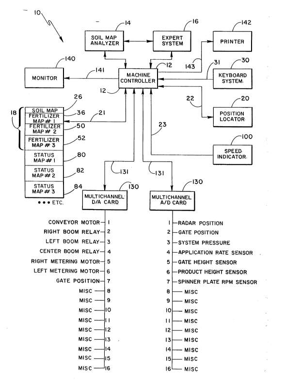
Figure 1 illustrates a functional block diagram of the
present invention showing the functional relationship
between the 80il map, the various fertilizer and status,
the soil analyzer, maps, and the machine controller;
Figure 2 illustrates a typical soil map of the present
invention characterizing the distribution of various soil
types of a field to be fertilized;
Figure 3, Figure 4 and Figure 5 each illustrate a
different fertilizer map indicating the desired level of
each respective fertilizer for the field to be fertilized;
Figures 6, 7 and 8 each illustrate a different
fertilizer map indicating the present level of each
respective fertiliæer in the field to be fertilized; and
Figures 9A-9B illustrates a flow diagram of the
algorithm for operating the present invention.
Figure 10 is a pictorial view of a tractor 11 and
dispensing system responsive to the control system.
DE8CRIPTION OF THB PREFERRED EMBODIMENT
Referring to Figures 1 and 10, a block diagram and a
pictorial view of a variable rate application system
according to the present invention is generally shown at
10. System 10 is adapted to a vehicle 11, such as a
tractor 11 (see Figure 10) and is based upon a
microprocessor based machine controller 12, wherein
controller 12 is a multitasking processing system based,
for example, on a UNIX operating system. Controller 12 is
the heart of the system for it coordinates and operates in
response to other major subsystems to control the
dispensing rate of multiple fertilizer blends contained in
respective product bins 13 (see Figure 10). Each
fertilizer blend, such as nitrogen, phosphorous and potash,
2nss~62
-8-
will be dispensed by a respective dispenser 13 from a
respective bin 15 to a conveyor 17 at a rate controlled by
controller 12. Controller 12 controls each dispenser 13
- via an interface card 130 based upon the location of the
vehicle 11, the speed of the spreader vehicle 11, the type
of soil beneath the vehicle 11, and the desired level of
each fertilizer blend at each particular location as the
vehicle 11 travels throughout the field. The dispensed
fertilizers are then conveyed via conveyor 17 to a
pneumatic spreader apparatus 19, as taught by U.S. Patent
5,028,009 assigned to the present applicant and hereby
incorporated by reference.
Two other major systems operate in conjunction with
each other and with controller 12 and are indicated as a
soil map analyzer 14 and an expert system 16 which are both
adapted to vehicle 11. Thus, the present invention is
taught as a modular system, however, is recognized that
soil map analyzer 14 and expert system 16 can all be
combined into one unit with controller 12. Soil map
analyzer 14, when activated, continuously samples soil as
the tractor 11 moves throughout the field and analyzes the
sample of soil to determine soil type and fertilizer
levels. Soil analyzers are well-known by themselves.
Controller 12 cooperates with soil map analyzer 14 and
processes the results of analyzer 14 and defines a new, or
updates or tempers an existing, soil map 26 which is stored
in a computer memory 18. Memory 18 can be, for instance,
comprised of RAM, ROM, or a virtual disk, and limitation to
a particular type of memory is not to be inferred.
Memory 18 is partitioned into seven separate portions
to store seven separate digital maps, the first being the
soil map 26 which indicates the type of soil distributed
throughout a particular field to be fertilized. However,
limitation to only seven maps is not to be inferred.
Referring to Figure 2, a river 40 is represented in a field
wherein portions 27, 28 and 29 indicate different soil
types at particular locations of the field, such as silt,
2095~62
g
clay or sand. Referring back to Figure 1, memory 18
includes three fertilizer maps 36, 50 and 52 which store a
predetermined desired distribution of each respective
fertilizer. The distribution can be custom designed based
on topography, soil type, the type of plants being farmed,
drainage characteristics, sun exposure, or any number of
factors which need to be accounted for to maximize the
yield of the plants. (See Figures 3-5). Three digital
fertilizer status maps 80, 82 and 84 are also stored in
memory 18 and provide the existing levels of each
respective fertilizer prior to a fertilizing operation, and
which can be updated or tempered during a fertilizing run.
(See Figures 6-8).
Each map stored in memory 18 is preferably a digital
map, digitally representing the respective information
throughout the field. For instance, the soil map 26 may
represent 100 acres of land, wherein the boundaries of the
map correspond to the boundaries of the field. The four
corners of the digitized map can correspond to the
southwest corner of the field, the southeast corner, the
northeast and the northwest corner of the field. Each map
is represented as a pixel array having a size of 250 x 250
pixels, for example, but limitation to this size is not to
be inferred. Further, while each map ideally represents a
portion of a field identical in size, limitation to maps
representing identically sized parcels of a field is not to
be inferred either. Maps based on boundary equations as
well to define a map, and limitation to a map based on a
pixel array is not to be inferred. Equations reduce the
size of memory necessary to store maps of large and
multiple fields, for instance. Each pixel or portion of
the map corresponds to a discrete portion of the field.
Each pixel of map 26 represents the type of soil for that
discrete portion of the field. The characteristics of each
type of soil is stored in memory such that controller 12
can access the soil map 26 via line 21 to ascertain the
soil type at a particular location. Similarly, each pixel
-lo- 2095462
of ~rtilizer maps 36, 50 and 52 and fertilizer status maps 80,
82 and 84 represent discrete fert.i]izer leve] ;nformation wh;ch
i.s accessed by controller ]2 as wi.ll be described shortly.
An x-y or position locator 20, such as a LORAN navigation
uni.t, but which also could be a global. posi.tioni.ng system (GPS),
i.s provided for conti.nuously provi.di.ng i.n real-ti.me machine
controller 12 via li.ne 22 the posi.ti.on of the system 10 in thè
fi.eld to be ferti.li.zed. Machi.ne controller ]2 coordinates the
positi.on i.nformati.on from posi.ti.on locator 20 to the particular
associated pixel or porti.on of the soil map 26, thus, machi.ne
controller 12 ascertains a parti.cular soi.l type represented by
the parti.cular pi.xel or porti.on of the soi.l map correlating to
the posi.tion identified by the locator 20.
U.S. Patent No. 4,630,773 to Ortlip teaches the coordination
of posi.ti.on 20 locator to the soi.l map where thi.s parti.cular
feature of the present inventi.on i.s known i.n the art as taught by
Ortli.p.
System 10 further compri.ses the plural.;ty of fertilizer maps
36, 50 and 52 shown as fertili.zer map number 1, fertilizer map
number 2, and ferti.li.zer map number 3, resepecti.vely, whi.ch are
defi.ned i.n parti.ti.oned memory 18. Each fertili.zer map i.s
i.ndependent from one another and corresponds to a parti.cular
porti.on of the fi.eld to be ferti.lized, si.mi.lar to the soil map
26. Ideally, each ferti.li.zer map is identi.cally scaled and
represents the exact same porti.on as the fi.eld soi.l map 26 so
that, for i.nstance each corresponding pixel fertilizer and soi.l
map corresponds to the same porti.on of land, thus providi.ng an
overlappi.ng effect of i.nformati.on. Each ferti.li.zer map i.s
preprogrammed pri.or to a fertili.zing run, for instance, by a
keyboard system 30 via line 3l, or from a prev;ously stored File
transferred via a tape or disk drive (not shown) into control.ler
~.2.
2095~G 2
As an illustration of the present invention,
fertilizer map 36 can correspond to the desired
distribution levels of a first fertilizer blend, such as
nitrogen, to be distributed upon the particular field.
Referring to Figure 3, a pictorial example of first
fertilizer map 36 is shown. The size of fertilizer map 1
can correspond to 100 acres of land and is represented
square in shape. The river 40 (shown in Figure 2) is
similarly defined throughout fertilizer map 36 as
illustrated. A first portion of the represented field
desired to have a first predetermined nitrogen level is
shown as portion 42, and can correspond to an elevated hill
or bluff defined in the field. A second portion of the
field 44 having a second and different level of nitrogen
can correspond to a low lying area of the field, which can
be a higher or lower level than the level represented by
portion 42. A third portion or the remaining portion of
the field represented by numeral 46 can represent a third
level of nitrogen desired to be attained upon dispensing
nitrogen by system 10. Thus, the first fertilizer map 36
can be custom defined such that different areas of the
field are correlated with a desired level of nitrogen.
This correlation can be based on factors such as the
topography of the field, the soil type, the draining
characteristics of that particular point of the field, or
the exposure of sun that part of the field represents.
Thus, any number of factors can be taken into account when
programming first fertilizer map 36.
Similarly, the second and third fertilizer map 50 and
52 can be similarly defined and partitioned in memory 18 as
shown in Figure 1. Referring to Figures 4 and 5, a
pictorial view of second fertilizer map 50 and third
fertilizer map 52 are shown, wherein river 40 is again
shown such that each map represents the same portion of
field. Each of these three maps 36, 50 and 52 can be
overlapped upon one another to see the ideal result of the
three fertilizers combined after application by system 10
209~62
-12-
for a particular portion of the field. Referring to Figure
4, a first portion 54, a second portion 56, a third portion
58 and a fourth portion 60 are shown representing the
different desired levels of a second fertilizer, such as
potash, which is desired at each particular point of the
field. Similarly, as shown in Figure 5, a first portion
62, a second portion 64 and a third portion 66 are shown
corresponding to the desired levels of the third
fertilizer, such as phosphorous, that is desired at each
particular location of the field to be fertilized.
Different portions of the field require different
levels of the various fertilizers due to the various
factors mentioned, specifically the topography, the
drainage characteristics, the sun exposure and the soil
type. For instance, as shown in Figure 4, the portion of
land adjacent river 40 represented by portion 58 may
require a specific level of potash which is different from
the rest of the portion of the field due to drainage
characteristics. As shown by Figures 3 and 5, the same
portion of land adjacent river 40 may not have any unusual
characteristics corresponding to these fertilizers such
that the distribution of nitrogen or phosphorous does not
particularly vary from the rest of the field. Referring to
Figure 3, if portion 42 represents the top of a hill, a
heavier application of nitrogen may be required, wherein a
higher level of potash represented by portion 54 in Figure
4 may also be required. Referring to Figure 5, a higher
level of phosphorous both at the top of the hill and about
a periphery of the hill as represented by portion 62 is
shown. Thus, each of the factors can be considered when
defining the various fertilizer maps.
Referring to Figure 6, 7 and 8, the current level of
the respective fertilizers of nitrogen, potash and
phosphorous are shown. Thus, Figure 3 and 6 represent
nitrogen, Figures 4 and 7 represent potash, and Figures 5
and 8 represent phosphorous. In Figure 6, the first status
map 80 (see Figure 1) is graphically shown representing the
-13-
current levels of nitrogen distributed throughout a
particular field. The second status map 82 shown in Figure
7 represents the current level of potash, and the third
status map 84 shown in Figure 8 represents the current
levels of phosphorous. Status maps 80, 82 and 84 can be
predefined in memory by first manually sampling portions of
the field and entering the corresponding characteristics
via keyboard system 30, or, can be continuously updated in
real-time by machine controller 12 in response to the
lo fertilizer information provided by soil map analyzer 14
based on the vehicle 11 location provided by x-y locator
2Q. Thus, a current and real-time record of the various
fertilizer blends in a particular field can be maintained
in memory for subsequent processing by controller 12.
Referring to first status map 80, as shown in
Figure 6, the distribution of nitrogen represented by
portion 90, portion 92, portion 94 and 96 are illustrated
to show the current levels of nitrogen. Referring to
Figure 7, second status map 82 shows existing levels of
concentration of potash at corresponding locations prior to
a pass of system 10. Various levels represented by
portions 110, 112, 114 and 116 are shown wherein each
portion represents a different level of potash. Referring
to Figure 8, third status map 84 is graphically illustrated
representing the current level of phosphorous, wherein
portions 120, 122 and 124 each indicate a different level
of phosphorous at each particular location of the field.
As will be described shortly, as system 10 is driven
throughout the field, or prior to a spreading application
if the maps are not to be changed prior to application at
the respective location, machine controller 12 will
ascertain inputs corresponding to the current location of
system 10 as provided by position locator 20 via line 22,
the soil type provided by soil map 26, the desired
fertilizer levels provided by each fertilizer map 36, 50
and 52, the current fertilizer levels provided by each
atatus map 80, 82 and 84, and will ascertain the speed of
2095~62
-14-
the tractor 11 via a speed indicator 100, which is
typically a radar based speed indicator that is well known
in the art. Machine controller 12 will provide all this
information corresponding to the current location of system
10 to the expert system 16. Expert system 16, as will be
described shortly, ascertains and processes the data based
on well known equations and data tables stored in memory
which relate the two types and interactions of fertilizers
and to the types of soil to subsequently, in real-time,
provide output signals back to controller 12. Controller
12 then provides the appropriate output signals to the
spreader and dispensing (not shown) system via a
multichannel interface card 130 for spreading or dispensing
the appropriate level of each fertilizer at that particular
location of the field to attain the desired level of
fertilizer shown in fertilizer maps 36, 50 and 52.
Referring now back to Figure 1, machine controller 12
is operatively interfaced via a pair of multichannel D/A
and A/D cards 130 and lines 131 to various devices on board
the tractor 11, including the dispensers from the bins. As
shown, the first card 130 interfaces a conveyor motor, a
right boom relay, a left boom relay, a center boom relay,
a right and left metering motor and a gate position device
to controller 12. Similarly, the second card 130
interfaces information corresponding to the radar position,
the gate position, the system pressure, the application
rate sensor, a gate height sensor, a product height sensor
and a spinner plate rpm sensor. Thus, machine controller
12 cooperates with, controls, and/or responds to each of
the various devices via interface cards 130, wherein
interfacing subsystems via interface cards to a controller
is well known in the art.
Also shown in Figure 1 is a monitor 140, such as a
color CRT monitor for visually providing an operator via a
line 141 a status of the various systems, as well as a
digital map with a cursor indicating the relative position
of the tractor 11 in the field. Thus, a color output
- 209S462
-15-
providing graphical representation of data, as well as
displaying all desired data simultaneously, eases the
operator's need to understand several difficult consoles
while operating system 10. A printer 142 is also provided
for providing a hard copy of various information via line
143 as selected by the operator via keyboard system 30.
OPERATION
As will be discussed shortly in reference to flow
diagrams shown in Figures 9A-9B, machine controller 12
provides outputs via interface cards 130 to dispensers 13
coupled to product bins 15 to dispense an appropriate
amount of each contained fertilizer onto conveyor 17 for
spreading by spreader 19. Expert system 16 comprises an
artificial intelligence device which processes all the
complex calculations associated with dispensing different
fertilizers onto different types of soil having different
preexisting levels of fertilizers. The calculations
performed by expert system 16 take into account the effects
- different fertilizers have on each other and when applied
to a particular type of soil. The basic calculations are
all well known and can be executed manually, but the time
required is extensive and cannot be performed in real-time.
However, some calculations are empirically derived and
considered proprietary trade secrets, taking into account
exhaustive studies including in depth research. Thus, the
present system is flexible and versatile for executing
customized and secret equations as well. Thus, expert
system 16 executes the number crunching in real-time to
provide a practical solution to dispensing different
fertilizers according to the present invention.
For instance, while applying 50 pounds per acre of
nitrogen to raise the nitrogen level 2%, by applying 50
pounds per acre of phosphorous to obtain a phosphorous
level of 2%, the level of nitrogen will fall below or rise
above 2~. Thus, different fertilizers interact when
applied to a particular type of soil such that the release
rate varies in a way which can be calculated, but wherein
2095~62
-16-
the calculations are extremely complex. Expert system 16
accesses prestored well-known and proprietary data tables
and executes equations in real-time as apparatus 10 is
driven throughout the field. Controller 12 responds to the
results from expert system 16 such that an appropriate
level of each fertilizer will be dispensed such that each
of the fertilizer maps 36, 50 and 52 are the net result
after dispensing each of the fertilizers. By taking into
account the soil type as provided by soil map 26, by taking
into account the current levels of each of the respective
fertilizers as provided by maps 80, 82 and 84, by
referencing x-y locator 20, and in response to the speed of
the tractor 11 provided by speed indicator 100, the
appropriate level of fertilizers are dispensed to yield the
net desired levels of each of the fertilizers.
Now referring to the flow diagrams in Figure 9A-9B the
algorithm performed by machine controller 12 will be
discussed in detail. First referring to Figure 9A, upon
initialization at step 200, if soil map analyzer 14 is
enabled at step 202, the system proceeds to step 204
wherein a sample of soil beneath the tractor 11 is
retrieved by analyzer 14 and analyzed at step 206. At step
208, soil map 26 is defined or tempered, as the case may
be, for the particular pixel or portion of soil map 26
corresponding to the current location of the tractor 11, as
provided by x-y locator 20. Soil map 26 can also be
predefined and stored in memory by manually entering the
soil type for each particular location of the field via the
keyboard system 30. For instance, information can be
manually obtained by sampling various portions of the
field, or ascertained by cn infrared camera from above the
field. Thus, soil map analyzer 14 does not necessarily
need to be activated for the proper operation of system 10
since the soil distribution in the field can be
characterized and stored in soil map 26 prior to a
fertilizing run.
~095462
After updating soil map 26 at step 208, or if æoil
analyzer 14 is not activated at step 202, the algorithm
proceeds to step 210 to determine that if expert system 16
is activated. If expert system 16 is activated, the
algorithm proceeds to step 212 wherein expert system 16
examines the entire soil map 26. The algorithm proceeds to
step 214 wherein expert system 16 ascertains the desired
fertilizer levels for the entire field of each of the
respective fertilizers as indicated by the respective
fertilizer maps 36, 50 and 52. Expert system 16 also
ascertains the current level of each respective fertilizer
by accessing status maps 80, 82 and 84, and which may be
updated in real time by analyzer 14 to provide the current
level of each of the fertilizers in the soil directly
beneath the tractor 11 prior to dispensing fertilizer.
However, current fertilizer levels may be considered
negligible and referencing status maps 80, 82 and 84 is not
mandatory for proper operation of system 10.
Upon examining soil map 26 at step 212, and
ascertaining at step 214 both the current levels of the
respective fertilizers beneath the tractor 11 from status
maps 80, 82, 84, and the desired levels of each of the
fertilizers from the fertilizer maps 36, 50 and 52, expert
system 16 at step 216 devises set point values to produce
a set point map file at step 218. The set point map file
is a file containing the set points of each of the
fertilizer dispensers 13 corresponding to a predetermined
speed for each location of the field to be fertilized, thus
providing normalized values. A reference set point for
each dispenser 13 is identified for each location of the
field such that the desired fertilizer levels stored in
fertilizer maps 36, 50 and 52 will be attained when the
tractor 11 is driven over the corresponding location of the
field as sensed by position locator 20.
It is noted that if soil map analyzer 14 if not
activated, expert system 16 can perform steps 212, 214, 216
and 218 to define the set point map file for reference as
2ns~462
-18-
the tractor 11 moves throughout the field for fertilizing
since the soil map 26, the fertilizer maps 36, 50, 52 and
the status maps 80, 82 and 84 are defined and not being
updated. If expert system 16 is not activated at step 210,
or upon conclusion of step 218, the algorithm iterates and
proceeds to step 230 to determine from the set point map
file if spreading of any of the fertilizers stored in the
bins 15 is necessary for the particular location the
tractor 11 is at.
The algorithm proceeds back to step 202 if the set
point values from the set point map file indicate that the
fertilizer levels are already at a desired level for the
present location and no spreading is necessary. However,
at step 230, if any of the fertilizer levels at the present
location as indicated by status maps 80, 82 or 84 do not
match the desired fertilizer levels as stored in fertilizer
maps 36, 50 or 52, then a corresponding non-zero set point
value as ascertained from the set point map file is
examined at step 232 to determine which dispensers should
be activated and at what setting. The algorithm proceeds
to step 234 and transfers the set points into memory at
step 234.
Next, referring to Figure 9B the algorithm proceeds to
step 240 where a device file is examined. The device file
includes relevant information for the particular type of
vehicle 11 or tractor 11 including the operating
characteristics of the equipment provided on the tractor
11. Next, step 242 is implemented wherein a machine status
file is examined. This includes the steps of ascertaining
via the interface cards 130 if various subsystems are in a
functional mode by performing the following steps. First,
at step 244, controller 12 determines if the conveyor 17
and the master spread controller 19 are on. The algorithm
loops back to step 244 until the conveyor 17 and spread
controller 19 are enabled. Then, step 246 is implemented
to see if boom number 1 of spreader 19 is on. If it is,
step 248 is performed to examine the set point of the
2095~62
.
--19--
corresponding boom. Subsequently, step 250 is performed to
see if boom number 2 is on, wherein step 252 is performed
to examine the set point of boom number 2. Finally, step
254 is performed to determine if boom number 3 is on,
wherein step 256 is performed to examine the set point of
associated boom number 3. The determination of whether the
conveyor 17 and spread controller is on, whether booms 1,
2 and 3 are on and the set points of boom 1, 2 and 3 are
all determined by machine controller 12 via the associated
interface card 130 as shown in Figure 1.
Next, step 260 is performed wherein radar data from
speed indicator 100 is examined to determine the speed of
the tractor 11 at that given moment. Next, step 262 is
performed wherein controller 12 calculates the conveyor 17
speed set point. Next, step 264 is performed wherein the
boom and conveyor motors are actuated, and each dispenser
13 coupled to the associated fertilizer bin 15 is opened
and set to the position corresponding the set point in
memory for the given tractor 11 location. The dispenser
position is adjusted proportionally if the current tractor
11 speed is other than the predetermined speed the set
point is normalized and referenced to. For instance, if
the tractor 11 is traveling at a speed twice the reference
speed, the dispenser 13 will be opened at a position twice
that set point such that the net amount of fertilizer
disposed per unit of land is uniform. Next, step 266 is
performed wherein the conveyor feedback signals from
conveyor 17 and spreader 19 are examined, wherein at step
268 a determination is made whether the feedback signals
are still acceptable. If not, step 270 is performed and
the conveyor set points are modified accordingly to ensure
the conveyor is again operating acceptably. Again, the
conveyor 17 transfers dispensed fertilizer to spreader 19,
as taught in the previously cited patent. Finally, the
algorithm proceeds back up to step 202 in Figure 9A again,
wherein the algorithm will proceed its way back down to
step 240 again eventually. The algorithm executes steps
209S462
- 20 -
240 through 270 whenever dispensing is necessary at the
particular location to attain fertilizer levels
corresponding to fertilizer maps 36, 50 and 52. The
conveyor set point and each dispenser set point is
5 appropriately maintained such that the appropriate level of
the respective fertilizer is spread onto the field
according to the fertilizer maps 32, 50 and 52.
In summary, based upon the soil-type information from
soil map 26, the respective fertilizer and status maps, as
well as the speed provided by speed indicator 100, expert
system 16 manipulates this information and provides a
resulting calculation to controller 12 such that controller
12 can generate the appropriate output signals to the
dispensers 13 coupled to each of the product bins 15
15 holding each of the respective fertilizers (not shown).
The dispenser set points can be calculated prior to a
fertilizing run by manipulating the current data, or
defined in real-time as the vehicle 11 samples the soil for
each particular location.
Given the discrete size of the field represented in
the maps, and based on the dispenser settings for each
location, the total amount of each fertilizer to be
dispensed can be calculated prior to a fertilizing run to
aid in planning. The path through the field can be random
25 or planned since the dispenser settings are coordinated
with position in the field. Overlapping a particular
portion of land will not result in a subsequent dispensing
at fertilizer since the current level maps 80, 82 and 84
are updated in real-time/ and the controller will realize
30 no additional dispensing is needed on the second pass.
Thus, the farmer is free to choose a path.
This invention has been described herein in
considerable detail in order to comply with the Patent
Statutes and to provide those skilled in the art with the
information needed to apply the novel principles and tc
construct and use such specialized components as are
required. However, it is to be understood that the
2095462
invention can be carried out by specifically different
equipment and devices, and that various modifications, both
as to the equipment details and operating procedures, can
be accomplished without departing from the scope of the
invention itself.