Note: Descriptions are shown in the official language in which they were submitted.
~al,Ln of TH>, zrrv~rrrzo~
The present invention relates to methods of determining the
reliability of line of sight radio wave propagation.
BACKGROUN1D ~F THh INV1~TI~1~7
Harsh climates encountered in areas, such as desert terrain in
proximity to bodies of water, are known to be very difficult for
Line-of-Sight (LOS) radio links because they cause frequent and
large reductions in received signal strength. These signal strength
variations occur because abnormal variations in the refractive index
of the lower atmosphere cause multipath transmission and/or bending
of beams emitted by the antenna. At frequencies below about 8 GHz
and on paths having adequate clearance, these signal strength
variations, otherwise known as time-varying fading, are generally of
two main types: (1) atmospheric multipath interference, which occurs
relatively rapidly and is caused by interference between two or more
refracted rays arriving at the receiving antenna by different paths;
and (2) reflection multipath interference, which occurs less
rapidly and is due to interference between direct and ground-
reflected waves. Tn terms of occurrence on a single radio link,
multip~th interference is the prevalent cause of degraded
transmission reliability resulting from anomalous atmospheric
structures. Hpwever, these two types of multipath fading can be
present at the same time and the number of fades tends to increase
with time due to atmospheric multipath increases along the path
r,
length.
The ability of a radio installation to withstand decreases in
received signal strength is represented by its fade margin, i.e.
the amount of power in dB that the average received signal
strength exceeds the receiver threshold. Evaluation of known LOS
radio systems shows that small fade margins of 4 to 6 dB were used
in the past to accommodate for multipath fading. These fixed
margins were originally disclosed in °'Radio Propagation y..
Fundamentals", Bullington, K., The Bell System Technical Journal
XXXVI(3), 1957, and were to provide for a link reliability of
90 percent for average climatic conditions. 'these margins,
however, have since proven to be too small for difficult
propagation environments and outdated in view of current LOS link
engineering methodology, which includes parameters for climate
location, terrain, and path length.
Current LOS radio design requirements are based to a consid-
erable degree on reguirements and experience in Europe. However,
propagation conditions in such couni:ries as Germany are benign
compared to those in the coastal areas of the Persian Gulf and in
other warm and humid climates. A large body of research about LOS
2C fading has been accumulated over the past 20 years, e.g. Vigants,
°'Number and Duration of Fades at 4 and 6 GHz," °'Space-
Diversity
Engineering," and Temporal Variability of Distance Dependence of
Amplitude Dispersion and Fading," The Bell System Technical Journal
50(3)(19?1) and 54(1)(1970 and Conference Record, International
Conference of Communications, Amsterdam, the Nether3.ands (1984),
respectively, and DCEC Engineering Publication (EP) 1-90, DCS
Digital Line-of-Sight Link Design (1990). Much of this knowledge
-2-
has its origin in the research performed for the engineering of
commercial LOS links in the United States, where in the 1980s at
least two-thirds of long distance communications traffic was routed
over long-haul LOS microwave radio. The initiatian of this
propagation research was related to more efficient use of the
frequency spectrum when the Federal Communications Comma.ssion
' reduced the number of frequency diversity protection channels from
two to one in each frequency band. This required understanding of
fading for a large variety of climatic conditions. The resulting
l0 models of fading and its countermeasures (frequency diversity and
space diversity) permitted commercial link engineering to meet
increasing reliability requirements related to increasing amounts of
data transmission in any network. Subsequent introduction of
microwave digital radio technology resulted in further propagation ~."
research an the in-band distortion of the frequency spectrum caused ..;
by multipath fading. The fading models developed from this research
included meteorological variables. This permitted generation of an
LOS propagation description for worldwide application when business
opportunities arose related to providing microwave LOS communiaa-
tions to countries such as Saudi Arabia anti other developing
dountries.
Today, the main focus is the single link propagation reliabili-
ty defined as the percentage of time that the deceived signal
strength is above the receivers 10-5 Bitc Error Rate (RER) thresh-
old. Commercial systems employing modern digital radio typically
require link rsliabilities of 99.99 percent or better. These
systems have been designed and are engineered on a per link basis to
~~~ ~~~~
accommodate clear-air received signal decreases of 40 to 50 dB due
to time varying fading of the received signal. It is important to
note that commercial systems are designed for fixed-plant operation
with generally good clearances and high antenna gains while military
LOS radios are rapidly deployed and moved in operations where good
sites and high--gain antennas are not the norm. The link engineering
for these military digital radio systems, however, does not
adequately take time-varying fading into account and does not
incorporate results from the large body of recent published work on
this topic.
~R~ of THE xraTxo~a
~.ccordingly, the objective of the present invention is to
provide a method of determining the reliability of military LOS
radio links by calculating multipath fade margins using relevant
environmental and operational radio parameters required to provide
a specified link propagation reliability.
:;.; Another objective of the preseni~ invention ,is to provide for
such a method which is applicable far a large range of climates,
.;
terrains, fade margins, and path lengths.
These and other objects of the invention are achieved by
automatically determining the reliability of any LOS radio link
given, these) parameters. Specifically, this method allows a
communications network operator to specify and determine the path
reliability (PR) for eacta backbone and extension link in a comrnuni-
canons network fox a given operating frequency, path length and
climatic factor. For each link, the fade margin required (RFM) for
s desired path reliability (PRD) is calculated by subroutines which
~~~
will be explained more fully in the Detailed Description of the
7Lnvention. Then, the actual fade margin of the selected link is
calculated using known radio parameters. Preferably, these known
radio parameters are stored in a database to facilitate access to
this information. Thereafter, the corresponding value of the actual
path reliability for the link is calculated using modifications of
known statistical models which take into account climatic and
geographic factors.
s~aa~F D~scR~rTgora of ~E Dz~.wzNCS .
0 Other features and details of the present invention will become
apparent in light of the Detailed Description of the Invention and
the accompanying figures wherein:
Fig. 1 is a schematic illustration of the various travel paths
- of destructive interfering multiple transmissions.
Fig. 2 is a graphical representation of typical atmospheric
refractivity gradient as a ~~nc~ion oi: percent of time the gradient
is exceeded.
Fig. 3 is a graphical represental%ion of a statistical descrip-
tion of deep multipath fading.
20 Fig. 4 is an ill~stratian of tine United States showing the
geographic variability of propagation conditions.
Figs. 5-7 are graphical representations of fading probabilities
fmr average, difficult and very difficult climates as generated by
the method of the present invention.
Figs. ~-10 are graphical representations of required fade
margins versus path length for average, difficult and very difficult
climates as generated by the method of the present invention.
Figs. 11-13 are flow chart diagrams showing one embodiment of
the present invention.
DETAILED DF.SCRIPTIOId OF THF INVEIQTTIOId
As described in the Background of the Invention, the principal
cause of atmospheric multipath fading on LOS radio wave paths is an
interference (cancellati~n) phenomenon that usually occurs when air
masses of different temperatures and humidities overlie each other.
without mixing. Because ~nese szrnLd ~au~~ ~.u~~-- .~-.---- __ ____
different paths, the receiver is subject to two or more replicas of
the transmitted signal as illustrated in Fig. 1. Fig. 1 also illus-
trates reflective multipaf:h fading which can also generate one or
more additional replicas of the signal. The replicas each with a
different amplitude and phase, can and often do combine destructive-
ly to reduce the received signal strength by more than enough to
cause unsatisfactory performance of the radio link. Typical
durations of each interference event range from a few seconds (40-dB
fade) to tens of seconds (20-dB fade)~while the number of interfer-
ence events in a night can range from fewer than ten to more than a
hundred. The mu7aipath-fading phenomenon is complex, time-varying,
nonstationary, and dependent on many physical quantities. Nonethe-
less these physical effects may be compensated fox by engineering
the radio links with adequate fade margins which can be calculated
for desired path reliabilities in the geographical locations and
climates of interest. The present invention, therefore, compensates
for~multipath fading by first statistically analyzing climatic and
geophysical structures and by calculating the required fade margin
for a desired path reliability on any xadio link given this
statistical analysis and radio parameters.
In order to analyze the effects of climatic and geophysical
structures on LOS radio wave propagation, certain atmospheric
structures must be classified into physical quantities. For
example, considering a normal daytime atmosphere whexe the index of
refraction decreases gradually as the height above ground increases,
the index of refraction may be measured in units, referred to as
N-units, that describe the deviation of the index of refraction from
unity, multiplied by 106. Thus, a representative, ground-level
index of refraction value of 0.000320 becomes a refractivity of 320
when expressed in N-units. gn the standard daytime atmosphere, the
decrease in height is essentially linear in the first km above
ground. The rate of decrease (the gradient) is generally denoted
as -40 N-units per km, which corresponds to the standard
equivalent earth radius factor of 4/3 used as a baseline for
engineering LOS links.
A statistical description of refractivity gradients occurring
in nature is obtained by measuring the difference in refractivity at
points that are separated in height by 100 meters. The result is a
probability distribution of the gradient, expressed as a percent of
time during which it exceeds a particular value. Such a distribution
. 3,s illustrated qualitatively 3.n Fig. 2, where the curve is broken up
into straight-line segments corresponding to different atmospheric
struatur~s: The break points ,in the curve and the shape of the
curve can change drastically with geophysical location.
The central portion of the curve araund the gradient of -40 N-
units/km represents linear gradients that affect terrain clearance
and change the relative phases of ground-reflected rays. The
multipath fading segment is centered on a -157 N-units/km value.
-7-
The presence of such gradients creates multiple ray paths which can
generate multipath fading. Experience indicates that gradients
substantially more negative than -157 N-units/km are necessary to
cause prolonged and severe reductions of received signal power
related to ducting.
Referring to the other end of the probability distribution, a
positive gradient can also cause prolonged and severe reductions of
received signal power. This is a result of a temporary blockage of
the LdS path, referred to generally as obstruction fading. ,.
Generically, the probability of the daytime propagation regime
is the largest (note that the percent scale in Fig. 2 is nonlinear,
the so~called normal-probability scale). As shown, the probabili-
ties of the ducting and obstruction fading regimes are relatively
small, while the multipath fading regime has the largest probability
among the anomalous propagation regimes.
Analytical models of multipath fading, formulated for the engi-
neering of radio links, describe multipath fading in terms of the
time during which the received signal power is smaller than a value
of interest. The time is accumulated over all fades in a month, .and
it is usually expressed as a percentage of a month, denoted by P.
As ~n example, a value of the fading probability P of 0.1 percent
corresponds to approximately 44 minutes per month.
the received signal level is described in te~ans of fade depth,
denoted by A, expressed in positive dB relative to the signal power
in the absence of'fading. Thus, if the received signal power of
interest is one percent of the power in absence of fading, then the
value c~f A is 20 dB:
-8-
For deep fades, when A is 20 dB or larger, the fading
probability P has a simple analytical form
P = 100 R 10'"no, A > = 20
where R is the multipath-fade-occurrence factor. For example, if the
fade occurrence factor is 0.1 and the fade depth is 20 dB, the
probability of fading is 0.1 percent. This means that the received
signal power is smaller than one percent of normal for a total of
approximately 44 minutes in a month.
The above behavior of the probability P as a function of the
0 fade depth A is a consequence of basic physics. This behavior
always occurs when fading is caused by multiple interfering rays.
The probability is usually plotted on a vertical logarithmic scale
as a function of fade depth on a horizontal linear scale. As shown
in Fig. 3, this probability becomes a straight line on such a plot.
The slope of the line is in decades of time (ratio of ten) per 10 dB
of fade depth. Thi..s is referred to generally as the Rayleigh slope,
after a theoretical ~?robability function that describes the result
of the interference of multiple rays. The vertical position of the
fading grobab'ility line in Figure 3 is determined by the fade-occur
20 rence factor R, which is a function of climate, terrain features,
radio frequency, and path d~.stance. The funotional form of R has
been f.he subje~~t of international propagation research for many
years: A CCP1U~ ~orm for R, described in "P~Iul~tipath Propagation at 4,
6 and ll MHz,",The Hell System Technical 3ournal, 51(2), Barnett,
1972, is
R ~ 6 C F D3 1 D'io
where D is the path length in km, and F is the radio frequency in
MHz (greater than 2000 MHz). Values for the climate and terrain
factor C are obtained from known maps. A low-reso~uzion qua~~~m-
tive propagation map for CONUS is shown in Fig. 4. Tn terms of
this map, for general planning purposes, C = 1 is recommended for
areas of average propagation conditions.
For difficult CONUS climates and terrains (e.g., the U.S.
gulf coast), C = 10 is recommended. The value of C = 10 is also
recommended fox like international climates and terrains, e.g>.
i0 Saudi Axabia. For worst case conditions, C = 100 is recommended.
This would be appropriat~ for cases of extreme heat and humidity
such as the Red Sea or hersian Gulf coastal plain, or equatorial
climates. For mountainous, dry, or northerly conditions, C = 0.25
would be recommended. For example, this would be appropriate for
the Rocky Mountains, Canada, and sections of Germany.
Given the path length and frequency, selecting the climate
and terrain factor, anct us~.rig the above equations, the site-
specific probability curve for the received power can be calculat-
ed. The link reliability is simply the quantity 1 minus the outage ~.
20 proi~ability which is determined by reading off the probability.
correspanding to the fade depth equal to the link fade margin.
The Rayleigh probab~.l:~'~Y function, however, cannot be used to
describe fade depths smaller than 20 dR (shallow fades). Such
fades can contain a ray that is dominant, which requires a differ-
ent mathematical model for their description and therefore, a
general multipath fadin5 model for received signal power is needed
for link engineering at,fr~c~uencies above 2'00 MHz, path lengths
-10-
from 10 to 100 km, fade depths from 0 dB to 40 dB, and for a wide
range of climates and terrains.
A very recent Canadian paper, "New Techniques for Predicting
the Multipath Fading Distribution on VHF/UHF/SHF Terrestrial Line-
of-Sight Links in Canada," The Canadian Journal of Electrical and
Computer Engineering, No. 2, Olsen and Segal, 1991, provides a
such a needed methodology for fading estimates in the shallow fade
depth region between 0 dB and 20 dB and for frequencies down to
100 MHz. The Olsen-Segal work is modified and used to meet the
objectives of this invention.
The Olsen-Segal result for P in the deep-fade region (A> = 25
dB) in percent is:
P = 10 coJao-s.» Ds.s Fo.a9 ( 1.~. I epI )-1.4 10c-~Jio~
where parameters not previously defined are
G = climatic factor in dB
~ep~ - the absolute value of the magnitude of path inclination in
mrad.
A relationship between G and the previously used climate
factor C will be established below. The path inclination angle,
ep, is the arctangent of a ratio where the numerator is the
difference of the heights of the branjmitting and receiving
antennas, and the denominator ie the path length. The exponents
of the parameters differ from those in the previously stated fade
occurrence factor R far CONUS. In general, such exponents and
additional parameters in the fade occurrence factor are obtained
empirically from experimental date.
-11-
'' ', ' .. ;r:: . :, ' ', ' ~ .'
. '
,
. . ; .
, w , : , .' ; . ;: ; ~ , ; ~ ;:.' . ;
.: -:. , . . . ; . ~ . . ; ,-: - r . '
,: ,.. ., . ,. : .'. : ,; ~, . :..
The Olsen-Segal deep-fade re~~o~~e~~~rical results were
developed from various experimental databases for path lengths
from 7.5 to 95 km, and frequencies from 2 to 37 GHz. However,
this model may also be used in the present invention for frequen-
cies down to 200 MHz and path lengths from 10 to 100 km. Also,
the path inclination effect will be assumed to be negligible,
i.e., ep will be set egual to zero.
The new Olsen-Segal result is a probability function Ps for
shallow fade depths (O to 25 dB) in percent,
Ps = 100 (1 - exp(-10~-9A12~)))
where the functional form of the shape factor q has been determined
from experimental data. The values of the coefficients in q are
determined from the deep-fade probability P, which is assumed to be
known.
The Olsen-Segal work provides two important capabilities
regarding the modeling of multipath fading on tactical LOS links.
First, the shape factor q permits description of shallow fades.
Second, the observation that available fading modeling techniques
apply at frequencies down to 200 MHz permits extension of such
techniques to tactical links . Given ttxese capapiiiua.es, Lily
geoclimati.c factors may be calculated to describe a worldwide range
of multipath~ fading conditions and their impact an tactical LOS
links.
The model for the probability of fading is composed of the
shallow-fade probability Ps and the deep-fade probability P. In this
description, Ps describes the fading.prob~ahila.ty when A<25 d~, and
P describes this probability when A>25 dB. Ps and P have the same
value when A=25 dB. The Olsen-Segal approach also allows use of
35 dB as the value separating the regions for the use of Ps and P.
The 35-dB value, however, imposes more constraints on the fading
model than the 25-dB value and is therefore not recommended.
The shape factor q in terms of Ps is an empirically derived
function that replicates experimentally observed shapes of shallow
fading and merges Ps smoothly into P at the transition point at A
- 25 dB. The expression for this shape factor q is
q = 2 -~ ICA ( qt -~ RA )
where ~cA and RA are empirically obtained functions of A
1 ~-0.016A ( ~ "~. ~ . 3 10-A/20 )
RA = 4 . 3 ( 10'AI2° + A/ 8 0 0 )
The parameter qt is constant for a particular Ps curve. Its value
is
qt = ( ( r - 2 ) / X25 ) - R25
where K25 and R25 are the respective values of ac.A and RA at A = 25
dB. The parameter r (which is distinct from the fade occurrence
factor R) is calculated from the deep-fade probability
r = -0.8 log(-ln(1-P25/100)) ,,
20 where In denotes the natural logarithm and P25 is the value of P
at A = 25 dB. , .
The shallow-fade probability Ps and the shape factor q
describe shallow fading associated with atmospheric structures
that cause multipath fading. The method is valid for such descrip-
tion when qt >_ -2. For qt a -2, the shallow fading i.& boo large
to be accommodated by this invention. Such, enhanced shallow fading
can occur when multipath propagation is superimposed on depressed
levels. of received signal caused by ducting or temporary increase
-13-
in terrain blockage due to the presence of a layer of moist air
over a ground-based layer of dry air.
The final step in the adaptation of the Olsen-Segal model for
worldwide use is to establish the linkage between the average deep
fading in Canada and in CONUS. This can be done by calculating
the fade depths for both Canada and CONUS at an identical proba-
bility in the deep-fade region using the same set of parametzr
values. The values selected are D = 40 km, P = 0.1 percent, and F
- 4 GHz since these represent those for which there are most
extensive experimental data. This calculation yields a Canadian
climate factor of G 5.8 dB corresponding to the average CONUS
fading value of C = 1. Since G = 0 dB is the Can~ldian average;
this result indicates that the average worst month fading in
Canada is one quarter that of COlv'US, as is expected for the colder
Canadian climate.
Given the above statistical analysis and calculations, valves
for the parameters of path length (I~), frequency (F), and climate
(G) axe selected. For example, it is recommended that
G = 0 dB for mountainous, dry, or northerly climates,
a.g., Canada or Germany
G = 5.8 dB for average climates, CONUS
G = 15.8 dB for difficult climates, COP7US or International
G = 25.8 dB for very difficult International climates
Further analysis would provide more detailed contours of G for
other international climates.
The multipath fading analysis described above is therefore
utilized to calculate link reliability as a function of fade
margin (O to 40 dB) for selected values of link path length {10 to
80 km) for frequencies ef 300 MHz, 1600 MHz, and 4750 MHz. The
latter are selected as representative of the 225-to-400 MHz,
1350-to-1850 MHz, and 4900-to-5000 MHz frequency bands, respec-
tively. For each of the three frequencies, three values of the
climate factor have been selected to span the climate range of
application: average CONUS (5.8 dB), difficult COP1US or Interna-
tional {15.8 dB), and very difficult international (25.8 dB).
Alternatively, the link fade margin has been calculated as a
function of link path length for selected values of link reli-
ability (90, 99, 99.9, and 99.99 percent).
Typical results of the calculations are graphically shown in
Figs. 5-10. Figs. 5-7 show the probability (reliability) results y.
versus the required fade margin for a fixed path length at 300 MHz
for~average, difficult and very difficult climates, respectively
and Figs. 8-1'0 show the required fade margin versus link path
length for a fixed reliability for average, difficult and very
difficult climates, respectively. Both sets of graphs are illus- ,
Crated as an example of the calculations which can be utilized in
the present invention because usually applications of this nature
begin with either a given path length or a given reliability. ~ .
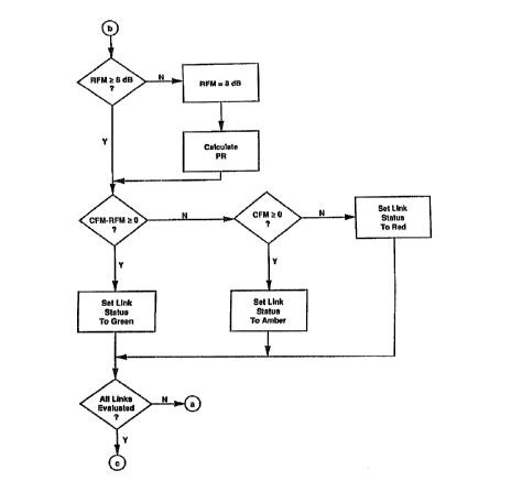
Figs.'Z1-12 are flog diagrams illustrating ane embodiment of
the present invention. As shown, a path reliability PR is speci-
fled for any ra,dia link an a network. Then, the radio and link
characteristics, which are known values that are readily calculat-
ed, are retrieved fram a database file and a fade margin capabili- ,~;;
ty (CFM) is determined utilizing a method commonly referred to as
Terrain-Integrated Rough Earth Model (TIREM) and inputting known
-15-
. ; .. ,., ,,,;; , ; ~ , . ,, , ," . ;;.. , 'v:: . ; ,., .,, ,. : ~. .. ,. ,
,, ,., ;,.. , . .. , :v
;v,' ::'.:, >,;',., ... ,:.
climate factors 9.nto this model. Thereafter, the required fade
margin (RFM) is calculated using the method described above.
Given these results, the fade margin capabilities of the
radio can be compared to the required fade margin and it can be
readily determined whether the radio parameters are sufficient to
establish ~ reliable radio link. As shown in Fig. 12, this may be
represented in a color schematic wherein if the capability fade
margin is less than zero and the difference between the capability
fade margin and the required fade margin is less than zero, then
~0 the link status may be set to red (or a failed link). Likewise,
if the difference between the capability fade margin and th~~
required fade margin is less than zero, but the capability fade
margin is greater than zero, then the link status is set to amber
(or the link is susceptible to failure). Finally, if the differ-
ence between the capability fade margin and the required fade
margin is greater than zero, then the link is set to green (or the
link is reliable within a certain percentage).
Of course, any number of correci:ive actions may be taken to
accommodate fox an unreliable link as those skilled in the art
20 would readily recognize. As such, the present metnoa may pe
incorporated into any number of automated systems wherein the
method is represented in a software program which automatically
outputs the status of any radio link andlor automates the correc-
tive acti,on(s) necessary to establish a reliable radio link.
Although the present method has been described and illustrat-
ed in some detail, it is to be understood that the same is made by
--16 - , ; ~.. , .
way of illustration and example only and is riot to be taken by way
of limitation, the spirit and scope of this invention being limited
only by the terms of the appended claims.