Note: Descriptions are shown in the official language in which they were submitted.
2114257
- 1 -
NAVIGATION APPARATUS AND METHOD
FIBLD OF THE INVENTION
The present invention relates to a navigation
apparatus and navigation method, and more particularly, to a
navigation apparatus and navigation method for determining
routes (or passages) between the present position of a moving
object and a destination to be reached by the moving object,
along which the moving object moves to reach the destination,
and presenting the route or routes to a driver through a
display to thereby support the journey of the moving object.
BACKGROUND OF THS INVENTION
A conventional navigation apparatus applied, for
example, to an automobile can be roughly classified into a
route-guiding type apparatus and a non-route-guiding type
apparatus.
The route-guiding type navigation apparatus displays
information about an optimum route for reaching a destination
on the screen of a display device. The optimum route for
reaching the destination is automatically calculated by a
computer accommodated in the navigation apparatus by inputting
the present position and destination of the automobile before
starting a journey. While travelling, a driver drives the
automobile guided by information about the route displayed on
the display screen until the automobile reaches the
destination. Nevertheless, the conventional route-guiding
type apparatus is impractical because of the difficulty
related to the ability of the driver, errors of a locator and
timing for indicating the route.
28469-2
2110257
- 2 -
The non-route-guiding type navigational apparatus
only displays a map as well as a present position, travelling
locus, travelling direction and the like in the map on the
screen of the display device and does not positively provide
the driver with guiding information. Therefore, this
navigation apparatus cannot achieve the original purpose of
navigation.
As described above, the information presented by the
non-route-guiding type navigational apparatus is less valuable
to the driver. Further, the driver is prevented from paying
attention to the forward direction of his automobile by
observing the map on the screen while driving. Thus) a safety
problem arises. On the other hand, information presented by
the route-guiding type navigational apparatus forces the
driver to travel along the designated route, thereby placing
strong psychological stress on the driver and thus raises the
possibility of causing danger. Further, according to present
technology, since an instruction on the route is given to the
driver without taking actual traffic conditions while
travelling into consideration, a problem arises in that the
navigational apparatus is less valuable when practically
applied.
Taking the problems of the conventional navigation
apparatus into consideration, an object of the present
invention is to provide a practical and safe navigation
apparatus and navigation method which can present valuable
information to a driver without applying stress to him.
28469-2
2110257
- 3 -
SUMMARY OF THE INVENTION
In accordance with the present invention there is
provided a navigation apparatus mounted on a moving object and
including an input section, a central processing section and a
display section, whereby when an initial position of said
moving object and a destination for said moving object are
provided to said central processing section through said input
section, said central processing section produces at least one
route along which said moving object can reach said
destination by using map data stored in a memory section, said
central processing section comprising: means for repeatedly
obtaining a current position of said moving object, said
current position varying from said initial position during the
movement of said moving object; possible route operation means
for repeatedly calculating two or more possible routes by
using data of said current position, said destination and said
map data stored in said memory section, any one of said two or
more possible routes connecting said current position and said
destination; means for repeatedly indicating said current
position, said destination and said two or more possible
routes on said display section; and possible area operation
means for repeatedly calculating a possible area defined by
maximum boundaries determined by two or more of said possible
routes, said possible area being indicated on the display
section, whereby a user may freely select any possible route
contained in said possible area.
28469-2
21 1 a2~~
- 4 -
In accordance with the present invention there is
also provided a navigation method comprising the steps ofe
calculating two or more possible routes for connecting an
initial position and a destination by using prepared map data
when said initial position and said destination are provided;
repeating said calculation step to repeatedly calculate said
two or more possible routes by using a current position of
said moving object when said current position is obtained,
said current position varying from said initial position
during the movement of said moving object; repeatedly
displaying said initial position or said current position,
said destination and said two or more possible routes to a
user; repeatedly determining a possible area the extent of
which is defined by maximum boundaries determined by two or
more of said possible routes; and repeatedly displaying said
possible area to the user whereby the user may freely select
any possible route contained in said possible area.
A navigation apparatus and navigation method
according to the present invention are arranged as described
below.
The navigation or navigational apparatus according
to the present invention is mounted on a moving object and
includes an input section, a central processing section, a
memory section and a display section. When data about the
present position and the destination of the moving object are
given to the central processing section, the navigational
apparatus produces a route along which the moving object can
reach the destination by using data, such as a map and the
28469-2
219257
- 5 -
like, stored in the memory section. The central processing
section includes a possible route calculation means for
determining two or more routes as possible routes when the
present position and destination of the moving object are
given. The two or more routes are displayed on the display
sect ion .
In the above arrangement, it is preferable that the
central processing section includes a connection route
calculation means for determining a connection route for
connecting between the two or more possible routes. The
connection route is also displayed on the display section.
In the above arrangement, it is preferable that the
central processing section includes a possible area
calculation means for determining a possible area defined by
the two or more possible routes. Likewise the possible area
is displayed on the display section.
In the above arrangement, it is preferable that the
present position detected by the locator of the moving object
is treated as a point contained in an area having a
predetermined extent by taking errors into consideration and
at least any one of the possible routes. The possible area is
determined by using a part or all of the routes contained in
the area.
The navigation or navigational method according to
the present invention comprises the steps of producing two or
more possible routes for enabling a user to reach a
destination when starting from a present position by using
prepared map data when the present position and the
28469-2
21' 0257
- 6 -
destination of a moving object are given, and indicating the
present position, the destination and the two or more possible
routes to a user.
In the above method, it is preferable that a
connection route which connects between the two or more
possible routes is determined and indicated to the user
together with the possible routes.
In the above method, it is preferable that a
possible area defined by the two or more possible routes is
determined and indicated to the user.
In the above method, it is preferable that the
present position of the moving object is treated as a point
contained in an area having a predetermined extent and at
least any one of the possible routes and the possible area is
determined by using a part or all of the routes contained in
the area.
BRIEF DESCRIPTION OF THE DRAWINGS
Fig. 1 is a diagram showing the arrangement of an
embodiment of a navigation apparatus according to an
embodiment of the present invention.
Fig. 2 is a flowchart showing the basic operation
for navigation according to an embodiment of the present
invention.
Fig. 3 is a diagram showing an example displayed on
the screen of a display section according to an embodiment of
the present invention.
28469-2
2~ ~ ~z~~
Fig. 4 is a diagram showing another example
displayed on the screen of the display section according to
another embodiment of the present invention.
Fig. 5 is a diagram showing a further example
displayed on the screen of the display section according to
another embodiment of the present invention.
DESCRIPTION OF THE PRBFERRED EMBODIMENTS
A preferred embodiment of the present invention will
be described below with reference to the attached drawings.
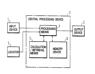
Fig. 1 depicts an input device 1; a central
processing device 2; and a display device 3 as an output
device. A navigational apparatus according to the present
embodiment fundamentally comprises the input device 1, the
central processing device 2 and the display device 3. The
navigational apparatus having this arrangement is mounted on a
moving object such as an automobile and the like. The present
embodiment will be described assuming that the moving object
is an automobile.
The input device 1 is installed in a front panel in
the vicinity of a driver's seat in the automobile. Operation
keys are disposed on the input device 1 to input various
instructions or data. These operation keys are operated by,
for example, a driver to input necessary instructions or data.
A voice input type input device or a touch screen type device
may be employed as the input device 1.
The central processing device 2 is composed of a
microcomputer which includes a processing means 4, a
calculation/retrieval means 5, and a memory device 6. The
28469-2
s
2~ i 0257
_8_
memory device 6 stores a program for carrying out calculations
necessary for performing navigation according to this
embodiment and data such as maps, roads and the like necessary
for the navigation. The processing means 4 has a processing
function realized by the program stored in the memory device
6. The concrete content of the processing performed by the
processing means 4 will be described later. The
calculation/retrieval means 5 functions to retrieve various
kinds of data about the maps or roads stored in the memory
device 6 in accordance with instructions from the processing
device 4 in order to obtain necessary data.
The display device 3 can be any one of a CRT, a
liquid crystal display, head-up display (HUD) on a window
shield or the like, and disposed on the front panel or shield
glass in the vicinity of the driver's seat. The driver can
obtain information necessary for reaching a destination while
driving the automobile by visually confirming the content
displayed on the screen of the display device 3.
The navigational apparatus includes a locator 7 in
addition to the basic arrangement. The locator 7 is used to
measure the present position of the automobile on which the
navigational apparatus is mounted. Various systems may be
employed as the concrete arrangement of the locator 7. That
is, there are various systems, such as, an arrangement making
use of a radio wave from a satellite; an arrangement making
use of a distance sensor or a directional sensor; and an
arrangement making use of oscillators disposed along roads to
provide positional information, and the like.
28469-2
_ g _
Next, the operation of navigation (travelling
support) carried out by the navigational apparatus having the
arrangement as described above will be explained with
reference to Fig. 2. The operation of the navigational
apparatus is carried out by various functional means realized
by the processing means 4 and the calculation/retrieval means
5.
First, an operation key of the input device 1 is
operated so that the destination is set and input to the
central processing device 2 (step 11). The destination may be
input by any arbitrary method. For example, the destination
may be input by inputting a number allocated to it.
Next, the present position of the automobile is set
by operating the operation key of the input device 1 and input
to the central processing device 2 (step 12). The initial
input of the present position at step 12 should be preferably
performed by a setting and inputting operation of the driver
to ensure the accuracy of the present position.
Further, the present position can be automatically
input by fetching an output signal from the locator 7.
The processing means 4 of the central processing
device 2 maintains the respective data about the destination
and the present position. Next, the processing means 4
determines respective positional data on the basis of the data
of the destination and the present position. Then, the
calculation/retrieval means 5 is operated so that a route
(hereinafter, referred to as a possible route), along which
the automobile can travel from the present position to the
28469-2
21 ~ 025
-lo-
destination, is calculated on the basis of the respective map
data and roads stored in the memory device 6 in addition to
coordinate data of the destination and present position. Two
or more of the above possible routes are determined and taken
out by the calculation/retrieval operation. The
calculation/retrieval operation is carried out by the
calculation/retrieval means 5 at step 13. Possible route
calculation means is realized by the processing means 4 and
calculation/retrieval means 5 to carry out step 13 for
determining the two or more possible routes.
Next, at step 14, coordinate data of the two or more
possible routes determined by the calculation/retrieval means
5 is maintained in the processing means 4 and then further
supplied to the display device 3. At this time, the
coordinate data about the destination and present position
input by the input device 1 is also supplied from the
processing means 4 to the display device 3.
The processing means 4 has an image displaying and
processing function for displaying a required image on the
screen of the display device 3. Therefore, the above various
kinds of data supplied to the display device 3 are converted
to a form which can be displayed on the screen thereof as
f figures .
As explained above, the present position, the
destination, and the two or more possible routes therebetween
are displayed on the screen of the display device 3 in the
state that their positional relationship is accurately
indicated on the basis of their coordinate data (step 14).
28469-2
2110257
-11-
Fig. 3 shows an example displayed on the screen of
the display device 3. On the display screen 3a, a point
indicating the present position of the automobile 21, a point
indicating the destination 22, and the possible routes 23, 24
existing between the present position and the destination are
indicated. In this example, the two possible routes are
displayed.
In the function executed by the
calculation/retrieval means 5 to determine the two or more
possible routes, it is usually preferable to obtain all the
possible routes. However, when there may be many appropriate
possible routes between the present position and the
destination, it is preferable to select a suitable number of
possible routes which are suited for display by adding
conditions for such selection. The conditions for selection
include, for example, a condition for selecting possible
routes along which the destination can be reached in a shorter
time; a condition for selecting possible routes along which
the destination can be reached in a shorter distance; a
condition for selecting possible routes along which the
destination can be reached by turning to the right and left
less times. These conditions can be arbitrarily combined by
giving them priority.
Also, it is preferable to select the routes which do
not have a directional regulation or other regulation as the
possible routes.
Furthermore, when determining the possible routes in
the renewal of them, there may be only one possible route. In
28469-2
2110257
- 12 -
this case, the display of the possible route on the display
device 3 is identical with that effected by the route-guiding
type navigation apparatus. Therefore, the display before
renewal is maintained. Furthermore, when the only one
possible route is a route where it is not required to turn
right or left, or a route which has a less complicated traffic
condition, or a route which does not cause danger at a
crossing point where the automobile must be turned right or
left because the locator 7 has a smaller amount of error, this
route may be displayed by the renewal.
When information regarding a traffic jam and/or a
traffic accident is obtained, a possible route is selected in
view of this information. When such information is not
obtained, a usual required time is used.
Unless the present position of the automobile does
not reach the destination, the present position is changed as
the automobile travels. When the present position is changed,
the possible routes must be determined between a new present
position and the destination. Thus, as shown in Fig. 2, it is
determined at step 15 whether the present position of the
automobile coincides with the destination. In this
determining operation, the processing means 4 fetches the
present position of the automobile measured by the locator 7
and determines whether this present position coincides with
the previously set destination.
When the present position does not coincide with the
destination at step 15, the process returns to step 12 at
which a new present position from the locator 7 is supplied to
28469-2
2110257
- 13 -
the processing means 4. At next step 13, possible routes are
calculated/retrieved between the new present position and the
destination. Then, the retrieved new possible routes are
displayed on the screen of the display device 3 and the
possible routes on the screen are renewed at step 14. When
new possible routes are not retrieved, the possible routes on
the screen are not renewed and maintained as they are.
So long as the present position of the automobile
does not coincide with the destination, steps 12 to 15 are
repeated, and when the present position coincides with the
destination, the operation of the navigation is completed.
The arrangement and the operation of the above
navigation apparatus may be modified as described below.
In addition in calculating/retrieving possible
routes at step 13, a route connecting between the possible
routes may be also calculated/retrieved. In this case,
connection route operation means is realized by the processing
means 4 and the calculation/retrieval means 5. The connection
route is supplied to the display device 3 together with the
possible routes and the like and displayed on the screen
thereof. A route 25 shown by a dot-dash line in Fig. 3 shows
a connecting route between the possible routes 23 and 24.
When a plurality of possible routes, connection
routes, regulated routes are to be displayed on the screen of
the display device 3, they are preferably displayed by
changing the color or the kind of lines.
When a travelling direction is regulated at many
places, or available routes are few, or routes are
28469-2
~:
2110257
- 14 -
complicated, in the area adjacent to the destination, it is
preferable to prepare the data for first routes leading to the
destination and for second routes for allowing the first
routes to access to a main route and store the first and
second data in the memory device 6 so that the data can be
arbitrarily retrieved, or to determine the first and second
data by the calculation effected by the processing means 4.
This processing is carried out at step 13. The obtained
routes are displayed on the screen of the display device 3
together with the possible routes and the connection routes.
Further) a possible area may be calculated/retrieved
by the calculation/retrieval effected at step 13. When a lot
of possible routes are determined by the calculation/
retrieval, the possible area is determined in such a manner
that the outermost two possible routes define the possible
area. The possible area is displayed on the screen of the
display device 3 instead of all the possible routes. So long
as the automobile travels toward the destination within the
possible area, it is ensured to reach the destination. In
Fig. 4, a possible area 26 is depicted. With respect to the
retrieval and display of the possible area 26, it is
preferable that when a possible area is initially displayed on
the screen by using an initial present position of the
automobile, the displayed possible area is maintained on the
screen even if the present position is changed. This is
because the possible area is a reference area which is used
for determining whether the automobile is located within the
possible area where it can reach the destination. When it is
28469-2
2110257
- 15 -
desired to change a reduced scale, or there are a lot of
available routes and therefore it is easy to calculate/
retrieve a possible area, the possible area may be of course
renewed, if necessary.
In the above description, possible area operation
means can be realized by the processing means 4 and the
calculation/retrieval means 5.
While travelling, the present position of the
automobile is periodically confirmed by making use of an
output from the locator 7 at step 12 in order to retrieve the
possible routes between a new present position and the
destination. Timing for checking the present position is
determined, for example, by the timing determined by a
predetermined time interval; the timing determined by an
output from a sensor for sensing a turning angle of a steering
wheel when the automobile turns to the right or left; the
timing sensed by a direction sensor when the automobile turns
to the right or left; and the like. Furthermore, the driver
may renew the possible routes on the display screen by
operating the input device 1 while driving, if necessary.
Furthermore, when it is taken into consideration
that errors are included in data regarding the present
position of the automobile obtained by the locator 7, it is
preferable that after determining an area including the
present position, two or more possible routes leading to the
destination or the possible area or both of them are obtained
on the basis of a part or all of the routes included in the
area, and they are displayed on the display device 3. The
28469-2
2190257
- 16 -
extent of the area is determined by taking the errors of the
locator into consideration.
With respect to the contents displayed on the screen
of the display device 3, a travelling locus up to the present
position, a travelling direction and the like may be displayed
thereon in addition to the aforesaid display items. In Fig.
4, an arrow 27 indicates the travelling direction.
It 1s preferable that the data displayed on the
screen of the display device 3 is designed so that it can be
visually confirmed as well. Fig. 5 shows an example of a
design concerning the displayed data, wherein a travelling
direction 28 is indicated. Furthermore, in the display
screen, an image to be displayed may be processed so that the
upward direction of the image always coincides with the
travelling direction. In this case, the image on the screen
is subjected to a rotation processing.
Since the displayed routes are difficult to visually
confirm in an area where a lot of routes are available, the
present position, the travelling locus, the travelling
direction and the like are preferably displayed by changing
the color or the kind of lines.
With respect to the display on the screen of the
display device 3, a map may be displayed in the possible area
or the entire screen as background information in such a
degree that the display of the possible routes, possible area
and the like does not become obscure, in order to improve the
visual interest of the displayed content. Furthermore, the
28469-2
211257
possible routes and the possible area may be displayed by
using thick lines or colors to improve the clarity thereof.
Both the present position 21 of the automobile and
the destination 22 to be reached are displayed on the screen
of the display device 3, as described above. In order to
display the present position and the destination on the single
screen, an area including both of them must be determined by
calculation. This calculation is performed by the processing
means 4 and includes, for example, a method of calculating a
line segment connecting the present position to the
destination and calculating an area to which this line segment
belongs; and a method of calculating an area including the
coordinate values of the X-axis and Y-axis of both the present
position and the destination as an upper limit value and lower
limit value.
Furthermore, with respect to the present position
and destination on the display screen) it is also possible
that both present position and destination are displayed in a
wide area and the wide area is divided into four segments, for
example. Alternatively, a segment as large as the segment
divided into the one fourth portion is established at the
center of the wide areas. Numbers are then allocated to the
respective segments, and a desired segment specified by a user
(by using its number) is enlarged to the screen's full scale
so that a suitable, enlarged display can be obtained by
repeating this operation.
In addition, a display on a suitable reduced scale
may be performed by reversing the above operation.
28469-2
2110257
- 18 -
Furthermore, it is preferable that processing
concerning highways and the like, having a specific entrance
and exit, is differentiated from that concerning usual roads,
and that the respective possible routes and the like are
independently determined. Since the shape of highways is
simple, no problem arises even if the route-guiding system is
employed.
According to the present invention arranged as
described above, the following effects can be obtained.
When the present position and the destination of the
moving object such as an automobile are input, two or more
possible routes along which the moving object may move to
reach the destination are displayed on the screen of the
display device, and thus the destination can be securely
reached on the basis of the plural possible routes used for
driving or travelling. In this case, since the two or more
possible routes are displayed for guidance, the driver need
not strictly follow one route. Furthermore, even if a route
with a directional regulation, which imposes a heavy load on a
computer for performing navigation control, is not contained
in possible routes, the driver may use the route with the
directional regulation by travelling from one possible route
to another possible route based on his arbitrary decision at a
field, and thus the driver can utilize the navigational
apparatus with a light heart. Furthermore, one of the two or
more possible routes can be selected by a driver who
determines the actual conditions of the routes and thus this
28469-2
2~~~257
- 19 -
system includes convenience which satisfies the psychological
state of the driver.
When connecting routes are displayed between a
plurality of possible routes, the possible routes can be
easily changed giving the driver increased driving
flexibility.
Furthermore, when the possible area is displayed,
since the destination can be reached so long as the moving
object travels within the area and information for guiding the
driver to the destination is given in the form of the area,
stress on the driver is further reduced.
Since the possible area is not displayed as a map
but as a figure, a load is not imposed on the driver when
visually confirming the figure and, also, a heads-up display
on a window shield (HUD) is made possible.
As described above, reducing the psychological
burdens on the driver reduce the possibility that he may be
dropped out from a guided route.
Since the present position of the moving object need
not be matched to a route along which the moving object
travels in the screen, the mental burden of the driver from
the navigational system and designation is reduced as well as
the degree of attention the driver must pay to the screen is
eased. Thus, increased driving safety can be ensured.
Furthermore, errors of a locator which have been
said to be fatal to a navigational apparatus, are allowed and
even if the present position of the moving object is not
strictly measured) the possible routes and the possible area
28469-2
210257
- 20 -
can be presented, and thus a system having high practical
applicability can be realized.
Since guidance made by navigation is not
concentrated to a less number of limited routes, a problem of
damming can be solved to enable routes to be effectively used.
In sum, the system is used with a moving object such
as an automobile for realizing solutions to problems
associated with accuracy errors of a locator, for reducing the
driving stress on a driver to thereby enable the driver to
safely perform driving, for increasing the efficiency of
routes by preventing concentrated use of particular routes,
and easing traffic jams.
28469-2