Note: Descriptions are shown in the official language in which they were submitted.
~92/22832 ~ Y PCT/VS92~0~132
~P~TIAL ~BA~R~~N$ RECOV~Y ~Y~T~
FIELD OF THE INVENTION
The present invention relates to a spatial measurement recovery
system which determines and xecords the positional, dimensional
and/or operational information regarding an object and/or an
en~ironment.
BACKGROUND OF THE INVENTION
lOComputer Aided Design and Drafting (CADD) ha~ b~come a stand2rd
design ~ool for manipulating and recording design information in
many industries, including the manufacturing and construction
industries, In this way, design information, such as for a
manufactured product or a construction project, is transformed into
a computerized model. CA~D models are accurate depictions of the
position, shape and orientation of the objects composing the
design ! and their relationship to each other and the environment
. in which they are contained.
: : Beliveau et al, U. S. Patent Application Serial No. 07/570,26~,
filed August 1?, l~go, and Dornbusch et al, U. S. Patent
; Appli:cation No. 0~/636,459, filed December 31, l990, the contents
of which are incorporated herein by reference, describes a system
and method in which a CADD model is used in conjunction with a
portable posl~ion~sensor:and a plurality of reference stations to
position dis~inguished points in an enYironment. In the system and
method~: disclosed ~by ~Beliveau ~t al., actual position and
orientation informatiQn of a vehicle, for example, can be
transmitted back ;to the ~computer and compared to the desired
:posltion~o~ the~vehicle in thè CADD model, and the~ the pos~tion
30~ of~the vehicle oan~be automatically corrected if necessary.
Unfor~unately,~a :fi~ished environment often differs from its
esi;gn, due to problems such as errors in design and tolerance
:capa~ility. Thus, there is a difficulty that the CADD model no
,
longer accur~tely represents the environment constructed therefrom.
~:CADD~models could be used to record the "as-built" or 9'as-is"
position, shape:~and orientation data of the components of an
environment, for example, an existing manufactured product or
indust~ial ~acility, if these data could be determined.
;
$UBS~ I l'UTE SHEET
WO 92/22832 2 1 1 1 1 1 7 PCr/11~92/0~
SUMMARY OF THE I~V~;N~1~10N
The present inventisn overcomes the above difficulty by
pro~iding a system and method which recovers ~he position and
orientation (spatial data) and the shape and operational
characteristics (descriptive data) of objects forming an
environment. This data may then be transformed into a CADD model
of the as-built or as-is environment.
The invention includes a data gathering apparatus and may also
include a model building apparatus. The data ~athering apparatus
determines and records th~ position, orientation, shape and, if
applicable, operational characteristics of objects. The model
building apparatus transforms th~se spatial/descriptive data into
a CADD model. When complete, this CADD model is an accurate
depiction of the spatial relationships and descriptions of all
objects within an environment. The modeled environment can then
be viewed via a computer monitor or other output device.
The data gathering apparatus incorporates a position and
measurement system, such as that disclosed in Beliveau et al. and
Dornbusch et al. described above. The data gathering apparatus may
: 20 also include a shape sensor which is capable of sensing the shape
of objects. A separate operational characteristic sensor may also
~: ~ be included to measure any distinguishing operational
chaxacteristics, such as temperature or material composition, which
aids in identifying a specific object from neighboxing objects of
2S similar shape. The data gathering apparatus collects any or all
of the shape, position, orientation and operational data for any
or all objects in:an environment.
: The:spatial/descriptive data may be tran~ferred to a model
,~ ,
building~ apparatus either in real time through an on-line
30 : communication device, or at a later time from stored memory.
The ~hape and opera~ional characteristics data permit the model
building apparatus to identify objects. This identification may
ibè achieved through comparison of the recovered descripti~e data
with detailed descriptive data of objects contained within software
35 : object li~xaries. Software o~ject libraries would contain the
de~criptive data for some or all of the obiects which are expected
;: within a particular environment. For exampl~, for an environment
including a chemical processing plant, the software libraries would
: likely contain descriptive data for pipes, valves, pumps and the
:: 2
SIJ~ JTE SHEET
~ 092t22%32 2 1 1 1 1 1 7 PCT/US92/~S132
lik~, of many sizes and shapes. Once an object identification is
made t the de~ailed descriptive data is placed in the CADD model
using the corresponding spatial data provided by the data gathering
apparatus. This reduces the amount of data collection required in
the field ~o provide a detailed CADD model of that particular
environment, and henoe will reduce the time required to construct
such models.
One pr~ferred embodiment of the data ~athering apparatus
includes a hand-held rod. A touch sensor is attached to one end
of the rod and senses when proper contact is made with an object.
A shape sensor and an operational sensor are also attached to the
rod. The shape sensor may include, for example, a sonar, while the
operational sensor may include, for example, a thermometer. These
sensors provide the descripti~e data necessary for identification
of objects. It is also necessary to know the azimuth and angle of
inclination of the rod in order to properly determine the spatial
data of objects. To this end, tilt sen~ors may be provided on the
rod to dete~mine th~ angle of inclination of the rod. Further,
a~ial rotation data can be useful in determining orientation. The
0 tilt sensors may also determine the axial rotation of the rod.
: Multiple positioning receivers allow the determination of both the
:azimuth and angle of inclination of the rod. A combination of tilt
sensors and posi~ioning receivers on the rod can be used~
: Acc~rding to a pr~ferr~d embodiment of the method of the
invention, the operator~carries the data gathering apparatus, e.g.,
rsd,~ and systematically places the touch sensor on the objects
forming the~ ~nvironment. The spa~ial/descriptiYe data of each
object i~ deter~ined and stored. The data then may be transferred
to a model building:apparatus. The received shape and operational
data are used to identify objects. Once an object is identified,
its position and orienta~ion are used to place the descriptive data
~ fqr th~ ob;ject in the CADD model. These steps are repeated until
: all relevant obje~ts of the real environment have been placed in
t~e CAD~ model.
35Simpler versions of the system and method of the invention are
~ nvisioned. For example, it is contemplated that an operator may
; input the shape and/or operational characteristics of the object
being position, for ~xample, 10" pipe, hot, directly into the model
buildi~g apparatus. Then the position and orientation would be
~: 3
5U135~ ITE SHIEET
WOQ2/2~32 ~ PCT/US92/05~
determined by the data collection apparatus. Once the
corresponding position and orientation data are transmitted to the
model buildin~ apparatus, the object can be included in the CADD
model.
BRIEF DESCRIPTTON OF THE DRAWINGS
The above aspects of the present invention can be seen from
the attached dr~wings, in which:
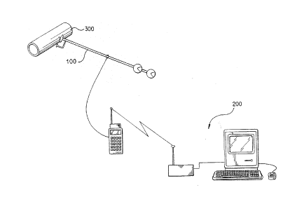
Figure 1 is a schematic drawing of a data gathering apparatus
in accordance with a preferred embodiment of thP invention
co~lecting data of an object:
Figure 2 is a schematic view illustrating the data gathering
apparatus shown in Figure 1:
Figure 3 is a schematic view illustrating a model building
apparatus in accordance with a preferred embodiment of the
invention;
Figure 4 is a schematic view illustrating the data gathering
ap~aratus shown in Figure 2 fitted with a wheel attachment for
mea~urement of co~tour~d surfaces in accordance with the invention;
2~ Figure S is a CC-h~r'tiC view illustrating the calculation of
the position of the:data gathering appaxatus in accordan~e with the
,
: in~ention; and
Figur~ 6 is a schematic view illustrating a po~ition and
measurement syst~m in con~unction with the data gathering apparatus
shown in Figure 2.
:.DETAILED ~ESCRIPTION OF THE ~k~P~K~;v EMBODIMENTS
:: A~spatial measure~ent~and recovery system in accordance with
; a~preferred e~bodiDent~of the invention is shown in Fi~ure l~
:30 Thxoughout the figuresr~like:numerals are used to designate like
eleme~ts.~
The data gathering apparatus 100~gathers spatial~descriptive
data of objects ~o~ming an environment for creating a "three-
;~?~ional map" of the environment~ A real time position35 ~ determination system is inte~rated into the data gathering
apparatus 100,~as will be~explained in mor~ detail belowO To this
end, the;data gathering apparatus includes one or more position
sensors 110 ~shown in Fi~ure 2).
~:~ 4
SUBSTITUTE SHEET
:~ :
~ ~i ~.".,~.. ,'',d r~.d. ~ ,d ,~
'~'D92/22~32 21 1111 7 PffCT/US9f2J05132
One preferred embodiment of the data gathering apparatus as
showr~ff in Figure 2 includes a rod 108 which is adapted to be hand
held by an operator. It is contemplated that the rod may include
flexible joints if the angular rotation of the joints is accounted
for when determining position and orientation data~ The operator
places the tip of the rod 108 on an object for which data is to be
gatherffPd. Upon beinfg placed on the object 300, the touch sensor
112 is triggered, which activates the compuker/data storage device
120.
The computer/data storage device 120 is preferably connected
to the rod via a commffunications link, such as via the cable shown
in Fiff~ure 2. Alternatively, the computer/data storage device 120
may be mountfff~d on the rod itself. The co~u~u~er/data storage device
1~0 serves as an interface for the operator tOf enter data and to
calibrate the positioning system and sensors~ The operator may
also communicate descr~ptive data ~i.e,, shape and operational
characteristic data~ and spatial data (iOe., position and
orif~ntation data) via a communications link, for example, by voice
over a "walkie-talkie" system ~not shown) ~ to another operator who
ZO inputs the data into another apparatus for storage and/or data
manipulation. It i5 contemp7ated that the cf~mputer/data storage
~ device 120 may also have the capability to store spatial data
:~ ~ a~d~or df~scriptive data of objects itself.
The computer/data storage device lZO selectiv~ly activates a
shape sensfDr 114 and an operational senf~tor ll~~ The shape sen~or
114 can be o~ any suitable type which provide~ data which will
distinf~uish thfe surface~features of the object 300. The shape
ensor 114 may al80 be capable of providing data rfefgarding interior
feature~. In one preferred embodiment, a sonar device may be usfeffd
; 30 as the shape senso~ . Such a sonar de~iff~e could i~clude one or
~ :more direct:ional audio tr~fffn~dllc~rs~ and receivers (not shown).
!~ f ~Difrectional aufdio signals would be aimed at different pointsff~n the
O~ff; ect ts determine the relative distance to the points. Thfe
distance to the points would give an inffi~ication of the shape of the
~: 35 object. In addition, a soundinq devire (not shown) in physical
: contact with the object 300 would transmit sound into the o~ject
and rereive the resultant reflected sound. The sounding device may
~: thus determine the thickness of materials composing the obje~t at
:
~ 5
SUBSTIT~ITE~: 5~EET
W~ 92/22832 2 1 ~ 1 1 1 7 PCT~U~g2/0~
the point of contact. It is also envisioned that such a sounding
device may be incorporated into the touch sensor 112.
The data gathering apparatus 100 may include an operational
characteristic sensor 116. The operational characteristic sensor
116 determines one or more operational characteristics of the
object 300. Such operational characteristics may be used to
distinguish an objec~ from neighboring objects of similar shape.
Operational characteristics which could be used as distin~l;~hing
traits may include, for example, temperature, material composition,
electrical current and/or color or the like. In one preferred
embodiment in accordance with the present invention, a ther~ometer
is used as operational characteristic sensor 116 to distinguish
objec~s having unique operational temperatures or temperature
ranges. In another preferred embodiment, a hardness testing device
I5 could be use~ as the operational characteristic sensor 116 to
distinguish objects composed of outer materials having unique
material hardness or material hardness range~. In a further
preferred embodiment, a magnetic flux detector could be used as the
operational characteristic sensor 116 to distinguish objects
carrying differ2nt electrical currents. In another preferred
:~ embodiment, a camara m~y be used as the operational characteristic
sensor 116 to disti~guish objects differing in color. It is to be
~;~ ;; understood that any desired operational characteristic and any
corre~ponding op~rational char~cteristic sensor 116 may be used in
connection with the system an~ method of the present invention.
The data qathering apparatus 10~ may be fitted with various
specialized at~achments suitabl for specialized data gathering.
For examplet~as shown~in Figure 4,:a wheel attachment may be u~ed
to enhance the gathering o~ data over contoured surfaces.
As~shown in:Fi~ure 5~, two position sensors 110 may be attached
along the axis of the rod. Two position sensors used in this
manner will proyide the minimum information necessary to determine
the position of the tip 130 of the data gathering apparatus 100.
In accordance wi~h the in~ention, the position of the position
sensors 110 along ~he rod 108 are determined in reference to at
: ; : lea t two fixed station~ 50~, a~ shown in Figure 6. EaGh fixed
'~ : stati~on preferably prQduces a set or multiple sets of counter-
rotating beams which rotate at a constant angular velocity. Such
:~ counter-rotating beams can be produced using multiple rotating
~:~; 6
Sll~ JTE SHEET
'''~92/22832 2 1 1 1 1 1 ~ PcT/us92/o5l32
heads and strategically placed reflective surfaces, as shown in the
Dornbusch ~t al. application referred to above.
~ ach fix~d station 500 preferably includes a la~er which
produces at least one primary laser beam and at least one secondary
beam w~ich are counter-rotated about an axis. The primary laser
beam has a predetermined ang~e of di~ergence (i.e., spread) which
is inclined at a predetermined angle from the rotational axis~ The
secondary beam has the same divergence and may have the same
inclination as the primary beam, but rotatas in the opposite
direction.
When the position sensor 110 is crossed by the two laser beams,
a horizontal angle can be determined from the time dif~erence
between the time of crossing of the primary and secondary beams.
Once these horizontal angles are known for three fixed stations
500, the point of intersection of three plan~s, and thus the three-
dimensional po ition of the position sensor 110 can b~ determined.
~ lternatively, if the fixed stations 500 each produce two
primAry laser beams a~d one or mor~, secondary beams, only two fixed
20 stations are required to determine the position of the po ition
sen~or~ 110 of the data gathering apparatus 100.
As shown in Figure 5, once the position of the positi~ning
~:~ senssrs 110 ha~e been dete~mined, the position of the tip of the
rod can be determined as follows:
X = L/D(X2 - X1) + ~2
y = L/D(Y2 - Y,) ~ Y-
Z = L/D ( 2~2 - ~1 ) + Zl
~: The orientat;ion of an object can be determined if the position
of three non-colinea~ points on the object are known. When the
3~ data collection de~ice touches an object, the location of a single
point i8 determined by the positioning system employed in the data
;j gal~hering apparatus 100. The position of additional points can be
; generated through analy~is of the shape da~a determined by the
shape ~ensor 114:. The accuracy of the determined orientation will
increase as the number of positions on the object from which the
~; position data and shape data are tak~n increases.
Once the positio~, orientation, shape and operational
characteristic data are determined, they are preferably immediately
stored in the computer/data storage device 120, or sent to the
:
$UE~S~lTa)TE 5HEE~;T
W092/2~32 2 ~ 1~1 1 1 l PCTlVS92/05 L
model building apparatus 200 via the communication links 120 and
220, as shown in Figure 3. The model ~uilding apparatus 200 stores
the incoming spa~ial/descriptive data for the current object 300.
The descriptive data is used ~o identify the object fro~ a li~t of
detailed descriptive data (e.g., actual design data) of previously
recorded objects.
This list of detailed descriptive data is preferably in the
form of software object libraries contained within the model
building apparatus 200. Small distances can ~enerally be
accurately mea~ured and precisely reproduced using commonly
available instrumentation and tools, such as calipers, computer
numerical controlled "CNCI' machining e~uipment and the like.
~owever, ~raditionally as the size of objects and the distance
between objects increases, the ability to quickly and accurately
measure these larger distances decreases. Th~ object libraries of
the model building apparatus 200 may contain the small dimensional
information, such as the design shape data or production shape
data, which is known to be accurate or which can be presumed to be
aGcurate to the minimum accuracy required ~or the work at hand.
~20 I~ this way, the model building apparatus 200 can use the shape
:data provided by the data gathering apparatus to identify the data
file in the object libra~y which correspond to the object 300.
Alternatively, the operator performiny the data gathering can
ente~r an identification code for the object into the compu~er/data~; 25 s~orage device or directly into the model building appar,atus 200.
This code would ide~tify the appropriate descriptive data file
without the need ~or analysis of the shape data of the object 300.
The identification code could be a manufacturer's part number, a
desi~n component~number or any code which uniguely identified the
object 300.
Once the descriptive:data for the object is determined, the
~:~ mod~l building~apparatus 200 links the descriptive data to the
position and orientation data generated by the data gathering
apparatus 100.
In operation, an operator systematically places the data
gàthering apparatus 100 on the objects composing the environment
in the spatial/descriptive data is desired. The
: spatial/descripti~e date for each object is stored by the
computer/data storage device 120. Alternatively, the
: 8
SlJB~ aJTE: 51~ ;ET
~92~2~32 ~ 7 PCT/USg2/05132
spatial/descriptive data is directly transmitted to the model
building apparatus 200. The model buildi~g apparatus 200 recor~s
the spatial/descriptive data~ matches the descriptive data to the
reference data contained within the object libraries and places the
S CADD image of the object in the CADD model of the environment.
The above is for illustrative purposes only. Modification can
be made, particularly with regard to size, shape and arrangement
of parts, within the scope of the invention as de~ined by the
appended claims. For example, it i5 envisioned that position-
reflectors or position-transponders could be used in place of the
position sensors 110, wherein a position and measurement system
would be employed in the data gathering apparatus 100 which gathers
radiation emissions such as laser or radio beams at the
transmitter.
Further, ~he invention is not limited to creating CADD models.
It is also en~isioned that the system and method of the invention
can be used in navigational systems, for example, to allow robotic
vehicles to navigate within their environments.
.
~ ~,
' ~ 1' ' 1 ! '
~, :: '
'~
~:
SUB~ UTE SHEEl~