Note: Descriptions are shown in the official language in which they were submitted.
2111358
2
METHOD AND APPARATUS FOR DETECTING BOUNDARY STRATUM
BACKGROUND OF THE INVENTION
1. Field of the Invention
The present invention generally relates to methods and apparatus for drilling
in a
substantially horizontal subsurface zone, and more particularly, to methods
and apparatus for
detecting the approach of stratum bordering the subsurface zone.
2. Related Patent
This application is closely related to United States Patent No. 5,278,507,
entitled WELL
LOGGING METHOD AND APPARATUS PROVIDING MULTIPLE DEPTH OF
INVESTIGATION USING MULTIPLE TRANSMITTERS AND SINGLE RECEIVER PAIR.
3. Description of the Prior Art
In recent years, there has been a substantial increase in the drilling of
"horizontal" wells.
Such wells often have much greater productivity than the more standard
"vertical" wells. It is well
known in the art that these "horizontal" wells are not necessarily horizontal
but rather have
boreholes which follow within the boundaries of a producing subsurface zone
which deviates from
the horizontal to some degree.
In the process of drilling such a borehole, it becomes necessary to guide the
drill bit so
that the borehole does not leave the boundaries of the subsurface producing
zone. A boundary of
a producing zone may be established by various non-oil bearing formations or
it may be established
by such borders as the oil-water contact level in the same producing
formation. In order to avoid
these boundaries and stay within the producing formation, means have been
developed in the prior
art, with varying success, to detect and subsequently avoid the various
boundary stratum.
Two methods for detecting a boundary stratum are illustrated, respectively, in
U.S.
Patent No. 4,786,874 and U.S. Patent No. 4,601,353. Each of these methods
employs a
directionally focussed sensor. One method generally describes a directionally
focussed gamma ray
tool and the other method describes a directionally focussed resistivity tool.
These tools show a
change in sensor readings as a boundary stratum is approached. The drill
string may then be rotated
A
x,92/22833 ~ ~ ~ ~ ~ ~ J PCT/US92/04871
3
as nosy to determine the position of the boundary stratum by the variation in
magnitude
of the sensor readings. Once the position of the boundary stratum is known,
the driller can
orient the bit to drill away from the boundary stratum.
In a paper entitled "Response of 2MHz LWD Resistivit,r a_nd Wiseline Indect;on
Tool
", presented by Barbara Anderson et al at the
SPWLA 31 st Annual Logging Symposium in June 24 - 27, 1990, there is a general
review
of comparing the responses of wireline induction and 2 MHz MWD tools in
dipping
formations.
While these methods have added to the art, they do have shortcomings. One
problem
with the above methods is that they operate under the assumption that a
particular zone,
including the borehole, is relatively homogenous as to its resistivity or its
natural gamma
radiation, which may or may not be true.
For instance, if the borehole, for some reason such as the particular type of
formation
or drilling fluid, begins to washout so that its size increases, the prior art
tools would most
likely signal falsely to the driller that the path of the borehole needs to be
altered due to the
approach of a boundary stratum. The prior art does not provide a way to
distinguish such an
occurrence from the actual approach of a boundary stratum. Unnecessary turning
in the
borehole can crate future problems with the drilling or perhaps with running
casing through
the borehole, as well as tending to slow the spoed of drilling.
Another common borehole phenomenon which can cause a false signal in the prior
art tools is an accumulation of mud solids which sometimes builds up on the
drilling bit,
particularly in horizontal wells. These accumulations, called mudballs in the
trade, have a
tendency to scrape off on the face of porous and permeable rock which
typically form a
producing formation.
Also, if a change in a characteristic of the formation as a whole occurred,
such as a
generally decreasing resistivity, the prior art would have difficulty, or at
least require
considerable time, to distinguish this occurrence from the approach of a
boundary stratum.
In some cases, while drilling through horizontal producing zones, the drillers
main
concern may be with the oil-water contact boundary stratum rather than other
boundary
stratum on the sides or from above the producing zone. The driller may wish to
keep the
borehole a certain distance above the oil-water contact level so as to
maximize the productive
life of the well. Also, the driller will probably not want to turn upwards
unnecessarily. In
WO 92/22833 ~ 1 ~ ~ ~ - ~~' PCT/US92/048'.z""'
4
such a case, the driller does not necessarily need a directionally focused
sensor to tell him in
which direction the boundary stratum is located because he already has
reasonable certainty
that the boundary stratum lays below the present borehole path. In fact, if
the motor type
drilling assembly is being used, due to the occasional necessity to change the
direction of the
bit, a tool with a directionally focused sensor may be focused in the wrong
direction to
indicate the approach of an oil-water contact boundary stratum and therefore
be unreliable.
Moreover, the need to reorient the tool may create undesirable drilling
operations. On the
other hand, the driller does~need a sensor tool that will be less subject to
giving flare signals
than the prior art tools.
In the above situation, the driller may wish to use a fixed directionally
focused sensor
for some purpose such as a greater depth of investigation being available.
However, even then
the driller requires a means for preventing spurious signals which so
frequently occur with
the prior art tools. .
The prior art provides no ao~ptable method for calculating the approximate
angle or
dip of an approaching boundary stratum. Such information would generally be
useful to the
driller for various reasons. It might affect the degree of turn the driller
wishes to achieve. The
driller will generally desire to make the borehole as straight as possible and
avoid making
relatively sharp turns for such reasons as given above. Normally, the driller
will want to
make no more of a turn than is necxssary to avoid the boundary statum.
Since information concerning dips or angles of the boundary stratum with the
borehole
is not available, there presently exists no system which is capable of
portraying on a surface
terminal or printout a schematic of the borehole along with any formations
detected while
drilling.
Other problems arise from relying on gamma sensors and resistivity sensors.
For
instance, a gamma ray tool cannot normally distinguish the oil-water contact
level in the same
producing zone. As previously stated, this is a boundary stratum the driller
desires to avoid.
Moreover, a gamma ray device generally has a depth of investigation of only a
few inches,
thereby providing essentially no useful information for this purpose.
Generally, in a vertical well, a nrsistivity tool can sense the oil-water
contact level but
usually requires the water to be somewhat saline so as to produce a clear
contrast between the
resistivities of the oil zone and the water zone. If the connate water, or
water entrapped in
the interstices of the formation rock, is fresh, or low in dissolved salts, it
may be difficult or
~r~.1 ~ 35
.~4 92/22833 _ ,.. ~.- ~,:,. ,., PCT/US92/04871
y
-.
even impossible for a resistivity tool to distinguish'rf~e oil-water contact.
In such a case, the
oil-water contact level is oftentimes distinguishable with high frequency
electromagnetic
sensors that measure dielectric constants, oil and water having different
dielectric ~co~a~tants.
Furthermore, U.S. Patent 4,601,353, using the gamma ray tool, is probably
~rii3t :~
suitable to drilling a well with a rotary drilling assembly as compared to
drilling with a motor
type drilling assembly. The gamma ray signal, being naturally subject to
statistical variations,
has a tendency to average out during rotations making neighboring beds
difficult to see.
Consequently, a need e~cists for improvements in techniques for detecting the
approach
of boundary stratum while drilling horizontal wells which will result in
greater reliability and
dependability of operation.
WO 92/22833
PCT/US92/048
6
It is the primary object of the invention to provide methods and apparatus for
detecting
the approach of a boundary stratum, and having sensors suitable for detecting
the expected
types of boundary stratum, to satisfy the aforementioned needs.
In this way, it should be possible to avoid false signals indicating the
approach of a
boundary stratum caused by discontinuities in the borehole or changes in the
producing zone
as a whole.
It is also the objecE of the invention to make measurements that, taken
together with
reasonable assumptions, lead to approximations of the dips or angles of
intersection of
boundary stratum with the borehole.
2111356
BRIEF DESCRIPTION OF THE DRAWINGS
Fig. 1 is a cutaway side view of a horizontal borehole through a producing
zone
illustrating a drill string in place within such borehole;
Fig. 2 is a cutaway side view of the horizontal borehole according to Fig. 1,
but
also including a washout in the borehole;
Fig. 3 is a cutaway side view of the horizontal borehole according to Fig. 1,
but
also illustrating a general change in a property of the producing formation;
Fig. 4 is a top view of a sensor tool having symmetrically reading sensors
with
different depths of investigation;
Fig. 5 is a top view of a sensor tool having directionally focussed sensors
with
different depths of investigation;
Fig. 6 is a schematic showing the effect downhole conditions have on depth of
investigations of sensors;
Fig. 7 is a top view of a sensor tool having groups of directionally focussed
sensors
with each group having sensors with different depths of investigation;
Fig. 8 is a block diagram of a system for displaying the borehole along with
boundary stratum detected while drilling;
Fig. 9 is an elevated view of an MWD tool in accordance with the present
invention
which is suspended at a vertical earth borehole as part of a drill string;
Fig. 10 is an elevated view of a well logging instrument in accordance with
the
present invention and showing in block diagram the circuitry used in actuating
the transmitters
and in processing the signals received at the single receiver pair;
Fig. 11 is a pulse diagram illustrating the time sequence of transmitter
pulsing;
Fig. 12 is a pulse diagram illustrating a time sequence alternative to that
illustrated
in Fig. 11; and
Fig. 13 graphically displays a typical "signature" illustrating the approach
of the
logging instrument to the entry and to the exit of a pay zone.
A
2111356
92/22833 _ , . PCT/US92/048~"'
8
Sensor tools of varying types with varying depths of investigation are well
known in
the art. While the preferred embodiment requires a sensor tool with at least
two depths of
investigation, the particular type of sensor used must be chosen with the
application in mind.
Generally a high frequency electromagnetic type of tool capable of measuring
more than one
characteristic of the formation such as dielectric constant and rtsistivity
will be suitable in
most cases.
Referring now to the drawings, and more particularly to Fig. 1, there is shown
generally a sensor tool 1 capable of reading into the formation at two depths
of investigation
in borehole 3 within horizontal subsurface zone 4. In the situation shown in
Fig. 1, deeper
reading sensor 7 will be the first sensor to show some sensor reading
variation due to the
approach of a boundary stratum 5.
As the sensor tool 1 goes deeper, a less deep reading sensor 6 may confirm
such a
signal. Since the sensor tool h will often be some distance "above' the bit
15, the borehole 3
already drilled prior to the indication given by the deep reading sensor 7 may
continue close
enough to the boundary stratum 5 for the less deep reading sensor 6 to confirm
the signal
given by the deeper reading sensor 7. Also, it may take a substantial amount
of footage before
the driller is able to effect a change in borehole direction, thus increasing
the chance that the
less deep sensor 6 will also detect the boundary stratum 5.
Referring to Fig. 2, should a borehole 3 variation, such as a washout 8, cause
some
change in signals, the first sensor to show a significant change will be the
less deep reading
sensor 6. In this way, by reviewing the logs at the earth's surface, for
example, the
"signature" log illustrated in Fig: 9 and discussed in more depth hereafter,
the driller is able
to distinguish borehole 3 changes from the approach of a boundary statum 5.
Similarly, if characteristics of the horizontal subsurface formation 4 begin
to change
as a whole as portrayed in Fig. 3, both the deep 7 and the less deep reading
sensors 6 will
nearly simultaneously begin to change. In this way, the driller will know
something other than
an approaching boundary stratum is causing the change so that a more
knowledgeable decision
can be made sooner as to choosing the subsequent desired course of action.
Sensor tools in Fig. 4 and Fig. 5 illustrate tools having symmetrical 16 and
directionally focused sensors 17 with more than one depth of investigation.
The technique
~Q 92/22833
PCT/US92/04871
9
of using more than one depth of investigation improves the reliability in
detecting proximal
beds of both symmetrical 16 and directionally focussed sensor tools 17.
If the particular drilling situation is such that the driller is concerned
only with the oil-
water contact boundary stratum 5 rather than possible upper or side
boundaries, one may
choose a tool having no directionally focused sensors 17. In such a case, a
sensor tool 16
with symmetrically reading sensors having more than one depth of investigation
will be
effective to detect the oil-water contact boundary stratum 5 in a reliable way
as explained
previously.
If, however, a sensor tool with directionally focused sensors 17 is used, then
having
two or more depths of investigation will increase the reliability. Using a
directionally focused
tool 17 will generally only be advantageous in this case if the sensor tool is
of a type that can
be focused downward and forward. This is difficult with most tools but can be
done with a
2MHz electromagnetic tool. Focusing the tool in the forward direction is an
improvement
over the prior art because boundary stratum can be detected sooner.
As a further advantage of having two or more sensors with different depths of
investigation, whether symmetrical or focused, the driller can maintain the
borehole within
a certain range away from such a boundary stratum. That is, the driller can
stay close enough
to the boundary so that the deep reading sensor 7a or 7b of Fig. 4 and Fig. 5
stays in contact
with the boundary stratum 5 but not so close that a less deep reading sensor
6a or 6b is in
contact with the boundary stratum 5.
A sensor tool 1 (see Fig. 1) having a deep reading sensor 7 and a less deep
reading
sensor 6 also allows approximate calculations of dips or angles that boundary
stratum make
with the borehole. It is well known in the art that the theoretical depth of
investigation of a
tool, generally based on geometric considerations, varies depending on the
type of formation
and conditions of the well bore. However, it is also a reasonable assumption
that the depth
of investigation of sensors of the same type, except for having a difference
in depths of
investigation, will be affoctod approximately the same when operating in the
same formation
conditions. This will be especially true if both sensors read rather deeply
into a formation
so as to be less affectod by borehole conditions.
Referring to Fig. 6, it is possible to see that if the depths of investigation
of sensors
are affected equally, it will still be possible to determine the angle A that
a boundary stratum
Sa or Sb makes with the center axis 8 of the sensor tool 1.
'~y '~ 3 ~ Q
WO 92/22833 PCT/US92/048'~
Assume that sensor tool 1 has a deep reading sensor 7 reading 10 ft into the
formation.
Then, at depth 1, when boundary stratum 5 is 10 ft. from sensor tool 1, deep
reading sensor 7
will begin to show changed sensor readings. Likewise, at depth 2, the less
deep reading
sensor 6 reading 8 ft into the formation begins to show changed sensor
readings. These two
readings would allow an approximate determination of the angle A the boundary
stratum
makes with the center axis 8 of sensor tool 1.
If in another formation, the depths of investigation of both sensors were
decreased by
1/3, then the angle A would still be the same but the detectors would not
detect the boundary
stratum Sb until it was closer to sensor tool 1. It should be appreciated that
the characteristic
"signatures" of a bed boundry, for example, as is illustrated in Fig. 9, can
be expected to
change with the angle between the borehole axis and the bed.
Referring to Fig. 7, a sensor. tool 10 with a plurality of focused sensors can
be seen.
Fig. 7 sensor tool 10 differs from the prior art tools used during the
drilling of horizontal
wells in that two depths of investigation are available for the sensor tool 10
for each sensor
group lla & llb, 12a and 12b, etc. Each sensor group, lla llb, etc., is
focused in a
different direction. Using sensor tool 10, if throe sensors, such as lla, llb,
and 12b,
detected the presence of boundary stratum Sc as shown if Fig. 7, a plane would
be delineated
by the sensor readings describing the orientation of boundary stratum Sc
relative to the sensor
tool 10.
Assuming the general angle of the sensors with respect to some tool reference
point 13
on the sensor tool 10 is known, as well as the depths at which the three
sensors detect the
boundary stratum Sc, and the orientation of the sensor tool 10 in the
borehole, then
approximate dips of the formation can be calculated using formulas well known
in the art.
While sensor tool 10 would probably be more suitable for acquiring dip
information
while using a motor type drilling assembly where sensor 10 would be in an
essentially non-
rotating part of the drill string, the sensor tool 17 of Fig. 5 might be more
useful in a rotary
type drilling assembly. As sensor tool 17 is rotated, a sampling mechanism can
sample the
readings periodically so that the effect would be the same or similar to
having a
multidirectional sensor tool such as sensor tool 10.
To determine the change necessary for a sensor reading to effectively signal
that it has
detected a boundary stratum, a statistical filter can be used. Such a filter
adjusts to expected
21 11356
11
sensor reading variations in a particular zone through statistical methods and
provides a signal
when sensor readings begin to vary more than would be expected.
A system for processing this orientation information is illustrated in Fig. 8.
The
signals from the tool 14 are fed to a surface computer 15 where the
information is processed
and printed out or displayed on a terminal 16. A split screen picture showing
the borehole
with plotted dips from the vertical and from above are provided to the
driller. The ability to
rotate views is also useful. Human interface 17 provides a way to input
assumptions as to the
size of the boundary stratum or to project a drilling heading onto the screen
to further aid the
driller in making necessary decisions.
Referring now to Fig. 9, there is illustrated the preferred embodiment of a
logging
tool 10' in accordance with the present invention while suspended in the
vertical section of
an earth borehole 12' on a string of drill pipe I4' from the earth's surface,
such drill string
including one or more drill collars 11'. A transmitter section comprised of
transmitters 16',
I8' and 20' are spaced along the length of the logging tool 10' from a
receiver section 22'
which includes a pair of receivers, sometimes referred to herein as R, and R2.
When using
transmitter frequencies which are different, for example, 2 MHz and 1 MHz, one
can, if
desired, use a pair of coils in each receiver, one tuned to 2 MHz and one
tuned to 1 MHz.
Each pair of such coils in a receiver can, if desired, be laid side by side
around the periphery
of the tool 10', or can be concentrically stacked. The transmitters 16', I8'
and 20', sometimes
referred to herein as transmitters T, , TZ and T3, respectively, are covered
over with a
non-conductive material as is well known in the prior art. Likewise, the
receiver section 22'
having receivers R, and RZ is covered over with a non-conductive material. The
transmitters
and receivers can be fabricated in accordance with teachings of U.S. Patent
No. 4,940,943
assigned to the assignee of the present invention. It should be appreciated
that the body of tool
10' is preferably made of steel in order to prevent the tool IO' from becoming
a weak link
in the drill string 14'. Typically, and in a manner well known in the art, one
or more drill
'~ x111356
12
collars 24' are threadably connected to a lower end of the logging tool 10'
and into which a
drill bit (not illustrated) is threadably connected.
It should be appreciated that the logging tool 10' also has the requisite
electronic
circuitry (illustrated in Fig. 10) for processing the signals received by the
receiver section 22'
in accordance with the present invention, thereby converting the received
signals into a log
or another indication of formation resistivity. It should also be appreciated
that the processed
signals can be recorded within the electronics section of the tool 10' or may
be fed by a
conventional telemetry system (not illustrated) to the surface for concurrent
processing and
readout at the surface. Typical of such a well known telemetry system is one
which generates
mud pulses which can be detected at the earth's surface and which are
indicative of the
processed signals.
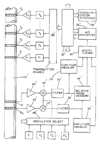
Referring now to Fig. 10, the well logging instruments 10' is illustrated as
having
a plurality of transmitters Tl, T2, T3 .... T". While the preferred embodiment
contemplates only
three such transmitters (Tl - T3), T" is illustrated for purposes of showing
that additional
transmitters can be used if desired. It should be appreciated that Tl, T2, T3
.... T" are
successively further spaced from the receiver pair RI and R2. The distance
between the coils
used for R, and Rz is typically six inches along the longitudinal axis of the
instrument 10'.
The distance the receiver pair and the successively spaced transmitters will
vary in some
applications as is discussed hereinafter in greater depth. Suffice it to say
at this point that one
typical configuration can show a distance between T, and R, /RZ of 12
inches/18 inches; the
distance between Tz and Rl /RZ of 24 inches/30 inches; and a distance between
T3 and R, /RZ
of 36 inches/42 inches, it being understood that the number "12/18", for
example, indicates
that the distance between T, and R, is 12 inches and that the distance between
T, and RZ is
18 inches, based upon R, and RZ being six inches apart.
Coupled, respectively, to the transmitter coils T,, T2, T3 .... T" are a
plurality of
amplifiers AI, Az, A3 .... A". The plurality of amplifiers, in turn, are
driven, respectively, by
oscillators F~, F2, F3 .... F". It should be appreciated that the frequency is
preferably on the
A
13 2111356
order of two MHz. Because of power attenuation at greater depths of
investigation such as is
the case with the longer spaced transmitters, it is preferable that the
frequency F~ >_ FZ > F3
>_ .... F". The preferred embodiment of the present invention contemplates
that F, will be 2
MHz; FZ will be 2 MHz; and F3 will be 1 MHz. However, based upon various tests
which
have been conducted, the invention works quite well in the range of about 0.5
MHz up to
about 4 MHz. The oscillators F~, F2, F3 .... F~ are controlled by the
Transmitter Enable
circuitry 30' which itself interfaces with a microprocessor 32', which in turn
interfaces with
a Communication Interface circuit 34' and an Analog to Digital Converter 36'.
The
Communications Interface circuitry 34' is conventional and provides an
interface between
computers, an internal memory, mud pulser, the microprocessor and operators or
computers
at the earth's surface after the tool 10' is removed to the earth's surface.
The differential receiver pair R~ and RZ are respectively connected to
amplifiers 40'
and 42' which are connected, respectively, to mixer circuits 44' and 46'.
A plurality of oscillators F,', FZ', F3' .... F"' are coupled through an
Oscillator
Select circuit 48' whose output is connected to the respective inputs of the
mixer circuits 44'
and 46'. The Oscillator Select circuit 48' receives its inputs from the
Microprocessor circuitry
32' .
The respective outputs of the mixer circuitry 44' and 46' drive Low Pass
Filters 50'
and 52' whose outputs drive, respectively, the Amplitude Measurement circuits
54', 56' whose
outputs are connected, respectively, to the Multiplexer circuit 60'. The
outputs of the Low
Pass Filter circuits 50' and 52' are also connected to the inputs of the
Relative Phase
Measurement circuit 62' .
In the operation of the device and the circuitry illustrated in FIG. 10, it
should be
appreciated that it is desirable to process intermediate frequency signals
rather than the
nominal 2 MHz signals received by the receiver pair Rl and Rz. Accordingly,
the oscillators
F~', FZ', F3' .... F"' are selected to be very near the corresponding
frequencies F~, FZ, F3 ....
Fn. For example, F"' can be set at a frequency of 1.998 MHz and thus provide
an intermediate
A
N
2111356
14
frequency coming out of the mixer circuit 44' or circuit 46' of 0.002 MHz (2
KHz). In a
similar fashion, FZ' and F3' can be set at 1.998 MHz and 0.998 MHz,
respectively. Thus, the
only signals that pass to the low pass filters 50' and 52' will be the
intermediate frequencies
which are obtained by mixing the frequencies of F,, F2, F3 .... F" with the
frequencies F,', Fz',
F3' .... F"', respectively. It should be appreciated that the amplitude
measurement circuit 54'
provides a measure of amplitude of the signal received by R,, whereas circuit
56' measures
the amplitude of the incoming signals received by the receiver RZ. Similarly,
the relative phase
measurement circuit 62' provides an indication of phase difference between the
signals
received at receiver R, and the signals received at receiver R2. As is well
known in the art,
the amplitude measurements and the relative phase measurements are both
indicative of
formation resistivity, which, through time multiplexing, provides any
combination desired of
the amplitude and phase measurements.
It should be appreciated that the frequencies F~, F2, F3 .... F" could all be
the same
frequency except for the practical considerations of power loss in the
formation due to the
increased distance the signals have to travel through the formation. However,
the conventional
multiplexer circuitry used with this system enables time separation between
the sequential
pulsing of the transmitters T,, T2, T3 .... T". For example, as illustrated in
Fig. 11, transmitter
T, can be pulsed for one second, followed by no pulse for one second, followed
by the
pulsation of transmitter TZ for one second, followed by no pulse for one
second, followed by
a pulsing of transmitter T3 for one second, etc., etc. Quite obviously, the
duration of the
pulsing for each transmitter can be varied, as well as the duration of no
pulsing in between,
for example, as illustrated in Fig. 12. It should be appreciated that the
expression "time
separation" between pulses includes the preferred embodiment of having one
pulse commence
immediately with the termination of the immediately preceding pulse. As
desired, the duration
of the pulses controlling T, may vary from the duration of the pulses for TZ
which may vary
from the duration of the pulses for transmitter T3 in order to provide a
signature of the
received pulses at receivers R, and Rz to better identify the transmitters and
thus the depth of
9,
..
21 1'~ 356
14a
investigation for the particular pulses being received. Thus, measurements are
made to
different depths into the formation by activating each transmitter at a
different time such that
only one transmitter is active at any one time and by recording or
telemetering the received
phase difference and/or amplitudes/(amplitude ratio) corresponding to each
transmitted signal.
Alternatively, the transmitters T,, T2, T3 .... T" could all be operated at
different frequencies
and could be pulsed simultaneously, with the separation of signals being a
function of
frequency difference rather than establishing the difference by time
separation in accordance
with the preferred embodiment of this invention. However, and quite obviously,
transmitting
all of the transmitter signals simultaneously will usually result in the need
for additional filters
and processing circuitry to enable the instrument to properly discriminate
between the
different frequencies.
An important feature of the present invention is the attaining of an induction
type
of sensor response for the shallowest measurement, even though the sensor is
operating at
radio frequencies (around 2 MHz). This contravenes conventional wisdom in this
area (see,
e.g. Rodney, P. F. et al.: "The Electromagnetic Wave Resistivity MWD Tool",
paper SPE
12167 presented at the 1983 SPE Annual Technical Conference and Exhibition,
San
Francisco, Oct. 5-8, 1983 and Dayev, D. S., High-Frequency Electromagnetic
Technigues of
Well Logging, "Nedra" Publishing House, Moscow (1974) 94-127, which would lead
one to
put the transmitter for the shallow spacing further from the receiver than is
either necessary
or desirable. The close proximity of the shallow transmitter to the receiver
effectively puts
the receiver within the induction zone of the shallow transmitter. Thus,
propagation effects are
A
~ 92/22833 PCT/US92/04871
largely negligible for the shallow receiver. This simplifies the borehole
corrections which are
needed for this sensor. Since it is extremely important that borehole
corrections be properly
applied to the shallow spaced measurements (since these are the most affected
by the
borehole), the approximate validity of geometric factor theory at this spacing
is a definite
advantage. Even more importantly, since the shallow measurement is in ttie
induction zone,
well established techniques for focusing the field of an induction sensor can
be applied to the
shallow measurement in order to minimize the influence of the borehole while
still obW fining
a shallow measurement in the formation (see, e.g., _Fyndamentals of Formation
Evaluation,
Donald P. Helander, OGCI Publications, Oil and Gas Consultants International,
Inc., Tulsa,
1983, P. 110).
It has been fairly well established that there is a geometrical limit to the
depth of
investigation of an electromagnetic energy rcsistivity sensor given
(diametrically) by the sum
of the spacings of the near and far antennas from the transmitter. This
applies to phase
difference based measurements: amplitude based measurements are about 50%
deeper.
However, these are all rules of thumb. It has been established that the depth
of investigation
is a function of the formation, borehole and invaded zone resistivities and
only approaches
this limit at high mud and formation resistivities. In a borehole with .03 ohm
meter mud, the
skin depth is 2.43" at 2 MHz. Generally, under this condition, one would
expect the actual
investigation depth to fall far short of the maximum investigation depth.
However, quite
unexpectedly, we have found this to depend on the placement of the receiver
antennas: the
closer the receiver antennas are to the transmitter, the better their depth of
investigation
approximates the ideal value under all conditions. Por example, the depth of
investigation
of a 24"/30" receiver pair under these conditions is about 22 inches:
following conventional
wisdom , one would expect a 9"/15" sensor to have a depth of investigation of
22
x 24 = 9 7/8"
54
where 22 is indicative of the 22 inch depth of investigation for the 24"/30"
sensor, the 54
comes from 24"+30", the maximum depth of investigation of the 24"/30" sensor
and 24
comes from 9"/15" sensor. The actual deptl; of investigation was calculated to
be 20" for the
9"/15" sensor; this was verified experiment<lliy. The results are even more
striking with a
6"/12" antenna spacing. Thus, as the receivers approach the transmitter, the
investigation
SUBSTITUTE SHEET
W0 9Z/22833 ~ 1 ~ 1 3 5 ~ PCT/US92/048''~
~,'
depth approaches the ideal investigation depth. In summary, we have determined
that the
preferred spacing between the closest transmitter and the closer receiver is
6" - 12". The
preferred range of spacing from the closest transmitter to the further
receiver is
12" - 18", preferably maintaining the G" separation between receivers.
This can be understood theoretically as follows. The fields of an induction or
propagating wave sensor are fairly well approximated by the fields of a
magnetic dipole.
The field of an oscillating magnetic dipole with its moment oriented along the
z-axis is well
l,:nown, as is given. by: (Electrom~netic Thcory by Julius Adams Stratton,
McGraw-Hill
isook Company, New York, 1941, P. 437.)
Note that when the product of the wave number and the distance from the near
transmitter is small, the static and induction terms tend to dominate over the
radiation term.
In other words, the sensor tends to behave like an induction sensor. It is for
this reason that
induction type response is observed when the transmitter is very close to the
receivers: the
radiation term is insignificant. Although this might appear simple in
retrospect, it was by no
means obvious until we had actually built a sensor with a 12"/18" spacing of
the receiver pair
from the transmitter. This sensor read far deeper into the formation than we
anticipated.
For this reason, one is forced to set the transmitter for the shallow
measurements much
closer to the receivers than would be expected, but one also obtains a 2 MHz
measurement
to which geometric factor theory can be applied (at least in approximation).
This is a great
advantage for it simplifies the borehole correction function and makes it
possible to make
accurate corrections for borehole effects. Note, however, in large diameter
boreholes that the
outer reaches of the borehole and the formation are again in the radiation
zone so that
geometric factor theory cannot be applied in large diameter boreholes.
Nevertheless, for
normal sized boreholes, the fact that the measurement is made in the induction
zone means
that methods traditionally used to focus an induction signal can be applied to
the shallow
measurement if desired in order to minimize borehole effects. As described in
Helander,
cited above, this focusing is typically accomplished in the prior art only by
adding two to four
additional antennas with currents directed opposite to that of the main
transmitting antenna.
Thus, we have discovered that with proper placement of the shallowest
transmitter,
an induction-like response is obtained. Therefore, geometric factor theory can
be applied to
the shallowest measurement. This is of great advantage since the shallowest
measurement,
by its nature is the most affected by borehole conditions. The applicability
of geometric
SUBSTITUTE SHEET
131! 92/22833 PCT/US92/04871
1~~ a~~~~~l~.~s .
factor theory implies that focusing techniques traditionally practiced at 20
KHz (a frequency
two orders of magnitude lower than that of the present device) can be used to
focus the
shallow sensor and nearly eliminate borehole effects.
It is important to understand that if the instrument follows the geometric
factor, the
depth of investigation is essentially independent resistivity. This means, qr
ite unexpectedly,
that spacing uniquely defines depth. Application of this finding includes the
following
methods, where L, is the spacing between T, and Rz, and L: is the spacing
between T, and Rz:
(1) L, designed to be R,o,~b,~ + 1" allows the majority of the signal to be
reflective of the
resistivity of a 1" annulus around the borehole. This virtually assures an Rxo
measurement. Clearly, L, would be different for different size boreholes, and
hence,
tools.
T 1 'z Diameter of Boreholes _L, Desired
.
6-3/4 8-ll2 5-1/2
9-7/8 6-1/2
8 9-7/8 6-1/2
12-1/4 7-1/2
8 14-3/8 8-1/2
9-1/2 14-3/8 8-1/2
17-1I2 10
(2) 1f L, is shallow enough, differcnccs between readings taken using the
shallow sensor
and those taken using deeper sensors could provide an estimate of shale
hydration.
This in turn is indicative of swelling and subsequent spilling (in some
instances).
Time lapse logging will show progression of these events, especially in
conjunction
with density measurements. In another application: if the shale is known not
to be
filtrate laden, density can be used as pore pressure indicates. Also, a good
Rxo can
be used to estimate porosity. If Rw is known from a clear water sand
Sw - F~ Rw where Sw is water saturation, F is
R, formation factor, M is the Archie
exponent, and It,~ is the resistivity
of the mud filtration.
SU9STITUTE SHEET
WO 92/22833 PCT/US92/048'"~
21 1 1 356
18
In a fully flushed zone, Sw = 1, R, = Rxo
:. F - R, xo and Fo( ~-'"
R",r
The object of a multiple depth resistivity tool, typically, is to obtain
resistivities of three or
more depths of investigation to identify the invasion profile. Since a depth
is generally
defined as the distance at which SO~a of the signal is obtained, significantly
different depths
are needed in order to be useful. In a resistive oil bearing formation we
have:
(Depth of investigation approximate inches)
12"/18" 24"/30" 36"/42"
25 SO 73
This is a good spread and is amenable to invasion modeling. However, the most
likely value
of such a tool will be in assessing invasion in water zones. This is because
in most instances
the water zone below the oil contact is much more likely to be invaded than
this oil zone
and yet bath will have similar permeability. A typical water zone will have
resistivities in
the vicinity of 0.2 ohm meters.
In developing this project, we had a surprising finding that the 12"/18"
spacing reads
a depth too close to the 24"/30" spacing in conductive formations. Also,
ideally, one should
want the shallow measurement to see Rxo, and so a 24" depth is too great.
Consequently, this
finding drives out a tool design requiring a closer short spacing. A spacing
too short will
increase the borehole corrections especially in saline mulls, so the preferred
short spacing
tools is somewhere between a C"/12" and a 12"/18". Of course, the distance
between the two
receivers may also be adjusted from the preferred six inches shown without
adversely
impacting the logic: The borehole corrections mentioned above will be more
significant at
the higher resistivities, where the depth of investigation differences arc
acceptable even at
12"/ 18". In order to minimize these corrections, conventional wisdom would
have persuaded
us to use a short spacing of between 12"/18" and say 20"/26" (expecting depths
of range of
13 to 21 inches). The new finding forces us to shorter spacings in a non-
obvious fashion.
An additional advantage to the present invention is achieved by using a single
pair of
receiving antennas. The stability (mechanical, thermal and electrical) of the
receiver
electronics is far more important than the stability of the transmitters
(which can result in a
9UBS11TUTE SHEET
21 11356
19
change of power level or a modest change in operating frequency). A sub can be
configured
with a plurality of transmitters, more than are actually' needed for a
specific application with
little extra cost. The transmitters needed for a specific application can be
selected, e.g., by
rotating the transmitter insert into a number of pre-set configurations which
link the oscillators
with the appropriate transmitting antennas. This provides a sensor that
requires minimal power
consumption and can be used both in large diameter boreholes (where one might
find it
necessary to choose a rather large diameter of investigation for the
shallowest reading) and
small diameter boreholes (where it may be necessary to select a transmitting
antenna
extremely close to the receivers in order to make measurements in the flushed
or invaded
zones of the formation). The invention extends broadly to the concept of
selectably moving
the transmitter position to suit the application, one embodiment being the
rotation of the
insert.
Moreover, although the preferred embodiment contemplates the use of a
plurality
of sequentially spaced transmitters, the invention is also inclusive of using
a single
electromagnetic energy transmitter operating in a frequency range of about 0.5
MHz-4.0 MHz
in conjunction with a single pair of receivers spaced in the range of 6"/12"-
12"/18" from such
single transmitter.
Also, the invention contemplates the generation of the characteristic
signature of
Fig. 13 using a single transmitter which is further spaced from the receiver
pair, for example,
at 24"/30" or at 36"/42", or also using two or more such longer spaced
transmitters to create
the characteristic signature.