Note: Descriptions are shown in the official language in which they were submitted.
WO 94/08312 PCI`/US93/~9128
. 21124~3
qr ~aGI~ilG 2~8q~f
':.
.FIB~D QF ~E: ~IO~
Thi~ in~rention relat~ to ¢oml?uter ge~lerate~
i~aagfis ~d, iXl particular, to a ~y~tem that ar0ate~ a
5~ ual i~age of~ a~ multidi~e~ional pace to pr~en* a
filt~red i~ag~ of variou~ thre~ di~e~sional phe~o~e~a
a~ fQatura~ that are containe~l ~ithiD th~ :
~ult~ai~iO~al ~pac~ as ~iew~a ~rom 2~y pred3fi~6~d
loou~ YithiD~ spac~.
O: :: ~ : P~OB~
~ , . . .
- :Et i~ a pro~bI~ in co~pl~:~ ¢om~ut~r co~trolll3d
~3y5t~19 t~at d-~l ~ith real ~orld ph~ao~e~ to pr~e~t
repre~entatio~: of the phe~oDIe~ ~snDer that i~
: botla i~orma~i~e to the user ~nd i~l a ~i3aple
15pr~se~tation~ Sormat. Comput~r geIIQrated grap~ r~
iquitou~:: a~d ar~ t~pieally u3~dl to praC~nt ~D
a~ rate re~prQsentation of ~ object, ~ phe~om2~a,
~ultidim~ion~l ~p~a~ a~d iBt~rac:tio~ ther~bet~
Co~laputer ~e~er~ed g~rap~ic~ ~re al~o u~g~d ~:tea~si-~ly
2 0ln ~i3wl~tio~: ~y~tems to pr~se~t ~ i:laage o~ 21 r~
world $ituatio~ or a hypothetic:al ~itu~t~o~ to a u~er
f~r tr~i~i~g~ a~alysis or other pu~po~ . CQmputer
~ge~erate~ graphics ha~t~ b~¢ome e:~trQmely ~ophi~ticated
a~ repre~e~t ~tr~m~ly co~ple~ ~d fa~ciful
25~3ituatio~s i~ a ~a~r that i~ ~ rtually li~liXe.
WO94/08312 PCT/US93/09128
~.,!,'~3~3 ~
-2-
~he application of computer graphic~ 5pan~ ~any
teeh~ologiQs and applicatisns.
o~e area i~ whi~h computer graphic~ has yet to
ma~e a signifi~a~t impact i8 the nrea of real time
di~play of comple~ real worla phenome~a. Ro~e
elem~ntary work ha~ ta~en place in thi~ area but
3ystem~ of great fl~ibility ~nd adaptability that c~n
handle e~tre~ely c~ple~ pheno~ena ~r~ pre~ently
una~ailable. It i~ therefore 8 proble~ to ~i~ually
~o display a ~omplex mult~dimen~ional and real time
: phe~ome~a in a 1arge multiai~en~ional space i~ a
ample m~nner that maps the reality to a predefined
user~ viewpoi~t.
:'
:~ :
:
; .
: :
:::
WO g4/0~312 PCr/US93/0~128
-`; 21245~
~OI.IITIO~
The ~o~e d~csibe~ proble~s are ~olved ~d
te¢h~iz~l ~ ce nohievea i~ the l~iel~ by the ~rirtu~l
reality image ge~eratioll sy~tem of the pre~ent
5 i:~ve:~tio~. Thi~ appa~atus ta~ multi~i~aensio:~al
~pace that contain~ real world object~ ph~ome~a,
be they ~t~tic or dy~ in natur~, ~d e~ble~
user to d,efine a poi~t ~d/or a p~th through th~
~ulti~ime~iona1 ~pae~e. The app~r~tu~ the~ plays
10 the ~view to t~e u er that woul~ be seen ~erom the poi~t
a~or p~th through the multidimen~ional spaceO Thi:~
~i~W i8 iltered through u~er aefill~ble
: ~ char~ct~ri~ti hat refi~e the r~l ~orld phe~omena
~d objec:t~ to a p~r~pective th~t i~ of intere~t to
15 t~e u~er. ThiY filter~d ~iew pre~t3 the u~r ~rith
~ irtu~l ~ie~ of the r~ality c:o~tai~es~ ~r th~ this
multi~liDtanqio~l ~pace, which ~irtual r~lity~ pre~e~ts
a~ta :to t~l~;u~er of o~ly objact~, view8 a~d phenomena
t~at ~re of p~rt~ r iutere~t to the user. Thi~
20: ~ apparatu~ highliqht~, emphasiz~, ael~te~
: reori~ts~ t~e ~ rQality contai~a ~ithi~ the
:
~ultidime~qioaal ~pace to pre~e~t a~ iDlage to t~ae las~r
: : ; of only wh~t ~ the user ~eed~ to ~ee to at:compli~h a
~tat~d t~qk. ~ The ~elactive pre~entatio~ of
i~forD~atio~ iD ~ r~al t~e of r9al ~rorld pheno~2~a
h~ u~Qr to proc eYQ t~l8 reauc~ ~ata ~et
co~t~in~d ~i~ tb~ i~age pre~e2~to~ ~y thi~ ~ppara~u~ to
perfor~ ~ ~e~ignate~ taslc in a ma~xler that ~e~retofor~
~r~s impo~ible.
~ The preferred ~odi~ns~lt d~oribed ~erein i~ t~at
of a~ ~irport operatiG~ y3t~ vherei~ ~ airport i~
loaat~d : in a preastermiD,ed loca~ion n ~ ~:
~ultidi~eD, ionsl ~pac:e and i~ surrou~ded by variouQ
thr~ im-nsion 1 topological !lurface featur-3. ~h-
'
~,
-.
W094/08312 PC~/USg3/09128
212 4~9 3
three dimen~ional air ~pace ~urrounding the airport is
typically managed by air tr~ffic controllers to route
aircraft in the vicinity of the ~irport into arri~al
_nd dep_rture pattern~ that _void the topologi¢al
feature~, various weather conditio~ around the
airport, ana other~aircraft that share the airspace
~ith ~ p~rticul~r flight Thi~ problem is extremely
¢omplex in nature in that the multidi~en~ion~l ~paoe
around the~airport contains fiYe~ objects such as the
airport ~d it~ surrounaing topologic~l feature~ a8
well ~8 dyn mic phenomena such ~g meteorological
event~ that ar- beyond the control of the air tr_ffic
controllers ~ell as dyn~mic phenomena, such a~ the
~ircraft, th~t c~n be indirectly controlled by the air
lS tra;ffic controll-r~ The dyn~mic phenomen~ ~ary in
time ana space ~D~ th~e mo~eoent of the aircr_ft within
this multiai~ nsional spaae mu~t be ~_nagea in real
time in response to re~l time an~ sometime~ ~udden
ch ng-s i~th-~et-orologic~l phenomena _8 ~ell _8 the
20 ~ pos~tion of other aircraft
No ~now~ system even remotely appro~ches
proviaing tb-~air tra~ffic controller , the pilot~ or
other potenti-l;users~ ~ith re~sonable distillation
; of all of the~dat~ co~taine~ with the multidime~io~al
ZS ~pac- aroun~;an airport Exi~ting a~rport operation~
i~clu~e a signific~nt ~mount of aata acguisition
instrumentation to provi~e the air tr~ffic controller~
~ ~ . : : .
a~ ~ell as ~th-~pilot~ of the ~ircraft ~ith ~ata
relating to ~e~ther, air traffic an~ ~patial ~-
rel~tion~hips~ of the aircraft ~ith re~pect to the
~irport an~ th- groun~ le~el The proble~ with this
apparatus i~ th~t all of the a~ta acqui~ition
in~trumentation is configured i~to indi~idual un~ts,
each adapte~ to present one set of narrowly define~
:
,:~
WO 94~0B312 PCI/US93/09128
-`` 212~59~
relev~t info~atioD, to the user ~ith little attempt
to integrate the plurality of ~y~tems i~to a unive~
in~tru~ent ~h~t ~n be n~aptsd t~ controll~bly pro~i~e
~n image of the multidimen3ional sp2~ce to the variou~
5 u~r~ ~ with each image being pre~qntes I to u~er in
texm of their ~peci~ic nse~ for information. T~
especi~lly i~port~nt ~i~ce t~e ~ir tra~fic controller
ha~ ~ sig~ific~tly dif~erent ~eed for information
th~ the pilot of the ~ircraft.
lo ~he apparstu~ o~ the pre~ent i~e~tio~ obtai~
~ata from a multitude of dat~ acgui~itio~ source~ and
controllably m-ld~ this i~formation i~to ~ ~ataba~e
that repre~e~t~ ~11 the inform~tion of inter2st
relating to this multidime~io~al ~pao~. Graphic
proce-~ing apparatus re~ponds to u~er i~put to define
a preaet~rmin~d point or path through the
multi~i~en~io~l space a~ well a~ ¢ertain
~: visualizatio~ oharacteri~tic~ for each indi~i~u~l
user. Th~ graph~c proce~i~g apparatu~ the~e, i~
real time, pr~o~t~ the u~r with a cu~tomized v~ of
:~ . the multi~imen~io~al ~pace in a Yisual for~ by
~el~ting i~formation that is e~traneou~ or co~fu3ing
and presenting o~ly the data that i~ of ~ig~ifica~t
rel~vance to the particular u~er a~ ae~i~ed by the
~ 25 filt-r. I~ a~ ai~ort op~ration e~iroDme~t, low
: ~: la~el wi~d ~hear al~rt systQ~ Lwa8) u~e grou~d-
: ba~ e~or3~to gesQrate data in~i~ati~e o the
:~ pre~nc~ ana locu~ of ~eteorological phenome~a 8UGh a~
~ind shear a~a gu~t fronts in th~ inity of the
airport. I~ additio~, terminal doppler weather rad~r
tTDWR) ~ay al~ be pre~e~t at the ~irport to ide~tify
the pre~ence and locu~ of met~orological pheno~e~a i~
the region ~urro~di~g th3 ~irport to e~able t~e ~ir
traffi~ controll~r~ ts guide the ~ir~rsft arou~d
W094/08312 PCT/USg3/Ogl28
2 1 ~ ~ ~ 9 ~
-6-
undesirable meteorologic~l phenomena such as
thunderstorms Additional data i9 av~ilable in the
form of LaND8AT d~t~ indic~tive of topolosical surf~ce
features surrounaing the airport Air traffic control
radar is ~lso available to indicate the presence and
lo¢us of ~ircraft within the ~pace around the airport
for ~ir traffic control purposes Colle¢tively, the~e
~y~tems pro~ide~data represent~ti~e of the immut~ble
characteri~tics of;~the ~ultidimensional sp~ce ~s ~ell
~s the dyn~mic ph-nomena cont~ined in the ~ir spa¢o,
incluaing meteorologi¢~l e~ents ~nd ~irGraft
oper~tions It i-~not uncommon for ~irport oper~tions
to t~e~place~in~a~zero visibility mode ~herein the
;
pilot's ~bility to obt~in a ~isual image of air sp~¢e
lS in front o f ~the~ircraft i9 impaired to the point
~her- the pilot i~ flying blind~ The pilot must rely
on the air tr~ffio oontrollers a~d raaar cont~ined
within th-~-ircraft to ensure th~t the pilot ~oe~ not
fly the~ ~ir¢r~ft~on ~ collision ¢our~e ~ith a ~ol~
ob~sct, such~s~nother ~ircr~ft or the topologic~l
features surroun~ing;the ~irport
The virtu~1~reality imaging ~ystem of the pre~ent
b ~ invention converts the ~ta obtaine~ from the
multitu~e~ o~f~ ~y~t~m- ~d ~i~tills the infonm~t~on
~ cont~ined therei~ into ~ u~liz~tion of the flight
p~th ~pre~ent1y~in ~front of~the ~ircr~ft Thi~
appar~tus c~ delete~e~traneou~ nformation, such a~
¢1Oud~, og,~-tc ~nd~i11u~trate~to th- pilot ~nd/or
the a~r tr~ffic controller only~phenomena that ~ould
:
be of ~ignific~ntlintere~t to the pilot, ~uch a8
angerous meteoro10gica1 ph-nomena~n~ other aircraft,
to present the~ pilot with ~ clear image of hazar~s
within the multidimensional space to permit the pilot
to chart course throuqh the-- h~z~rd~ Yithout the
W094/08312 PCT/USg3/0~128
21215~3
pilot being ~ble to ~ee the~e danger~ ~ith the ~ake~
eye.
The specific ex~mple note~ ~bov~ imply one of
m~ny ~pplic~tion~ of this concept uhich oper~tes to
S filter v~t ~mounts of d~t~ typic~lly found in
~isual im~ging situation tQ present ~ "clearer image"
to the user ~ ~define~ by the specific needs of the
user. ~he user therefore sees only ~h~t they need to
see ~na c~n ~complete t~sks th~t heretofore ~ere
~ impossible due to the visu~l overlo~d encount~red in
~y ~itu~tions, such ~8 flying ~n ~ircr~ft through
fog or cIouds or~not being ~ble to i~entify ~ ~ind
she~r event~ in~ a meteorological phenomena of
signific~nt ~tent ~nd c~mplexity. An a~ition~l
S c~p~bility of this y~tem is the prediction Qf future
st~tes of the~dyn~ic pheno~en~. D~t~ is collected by
the~ ~ultitud-~of~data ~cguisition system~ over
plur~1ity ~Or ~ampling interval3 ~d c~n be
apolate~ to~illustrate the state of the dy~amic
20;~ ~ ph-noo-n~ ~ ; f~ture sampl~ng int~rval~. Th~s
cap~bility~nabl-s the air traffic co~trol supervi~or
to~modQl the~eather activity around the airport to
pro~id-~infor ation to plan airport operations for the
immeaiate~future. -~
;: :~: : : : :: .:
:: : : ~ .,;,
.
: :
WO94/08312 PCT/US93/09128
21~4~93
-8-
BRI~F D~8CRIPTIO~ OF TEE DRA~I~G
Figure ~1 illustrates in block di~gr~m form the
overall architecture of tho app~ratu~ of the pre~ent
in~ention:
Figures 2~ lllustr~te in flow di~gr~m form the
operation of th- ~arious ~egments of the improved
~eather alert system;
Figure 5 illu9trate~ in block aiagr~m form the
overall srchitecture of the improved ~eather alert
10 system;
Figure 6 illu~trates a plot of a typical ~irport
conf~iguration,~incIu~ing ~L~A8 ana TDWR in~t~llation~
~nd~typ~cal~è~th-r cond~tion~;
Figure~ 7 ~ 12 illu~tr~te ~n e~ample of
lS con~erting~ ~the compact dat~ repre~e~tation of
ph-nom-n~ to~ ~;a three-dime~sional object
represent~tion~ d
Figur~13~ 17 illu~tr~te typical vi~ual image~
pro~uce~ by ~t~ appar~tu~
: ` ` : :
.
WO g4/08312 2 1 2 ~ 5 9 3 Pcr/US93/09128
_9_
DBTAI~D DE8C~U:~IO~
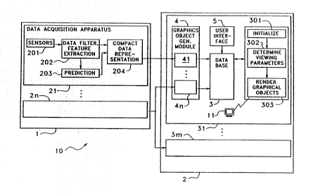
Figlsre 1 illustrates i~ bloclc diagra~ fom~ the
overall xrchitQeture of ~h~ virtual reælity im~gi~g
~yst~m lO of the pre~ent inve2~tion. lErithi~ the
S virtual reality i~gi~g sy~te~ lO, a dat~ acquisitio~
ys~tem 1 fu~ctio~s to coll~ct s~d pro~ce th~ real
t~e ~at~ thst is repre~e~tative of the
multi~ime~ional ~pac~ ~d the feature3 an~ ph~ome~a
extant therei:l~. Graphic~ 3ysteDl 2 i~u~ation~ to
utiliz~ the real time data that i 5 produ~e~ by the
datz~ acquisition ~ y~t~ 1 to produce the ~ ual
~isplay~ required ~y the plural~ ty of user~ . To
accompli~h this, a bared datab~ 3 is used i~to
~rhich the real tiDIe data i~ written by the data
~5 acqui ition ~ yQtem 1 and acce~ea by the variouQ
proc~ing ~e~ent~ o~ g~aphic~ ~ubsyst6~ 2., A u~r
:dat~ input device 4 i~ pro~rided to e~able a u~r or a
plurality of u~er~ to ~nter ~ata i~to the graphic~
sub~yst~ 2 indicst e of the particul~r illformation
: ~ 2 0 that: each of t31e plurality of usar~ ~e ires to ha~.re
~lisplayed o~ the o orre~po~ding aisplay de~ic~
operatio~r the data acqui3itio~ 3ub~3y8tem 1 ¢o~prise~
a plurality of ~data acguisition apparatuQ 21-2n, eac:h
of whic:h produae data rep esentative of mea3ur~ent~
,: ~ . .
25 ~ perfor~d ~o~ ~ t~e phe~om~na or featur~ th~t are
located in the~ nlultiai~e~io~al 8paOQ. ~rhe~e dalta
acgui~ition ~pparaLtu~ 2sl a~ pro¢~ the real tim~
measureme~t ~ata into comp~¢t data r~prese:~lt~tio~ of
th~ ph~no~e~a s~d f~ature~, u~ ompa~:t data
30 xepr~ssntatis~ ~re tra~itted to graphic~ ystem
2 or proce3sing i~to th~ Yi~ual i~gss. The graphics
311b y~te~ 2 :~o~ert~ th~ compac:t data repre~tations
produced by thQ plurality of data acquis~ition
~Ipp r~tu~ 21-2n into visu~liz tions ~ d~f:L~0d by e~ch
W094/08312 PCT/US93/091~8
9 3 -lo-
of the u~era of the Yirtual reality imagi~g sy~tem
100~ ~hi~vi~ualization i produced ~y performing
databa~Q tr~sver~al to pre~ent the data i~ a for~ ~nd
format of interest to e~ch of the uaers.
Aviation Weather DisDl~Y 8Y~tem
A typic~l ~pplioation of thia app~ratu~ ia ~n
; ~i~tion w-~th~r~diapl~y syatem whoae d~ta a¢qui~ition
ubaystem~ m~k- ua- of ~ plurality of aviation weather
in~tru~entation that are u~ed i~ ~nd ~bout ~n airport
lo inat~ll~tion.~ The~ ~viation we~ther i~strumentation
; m~y in¢lud- ground b~aed ~enaors such ~5 rad~r,
lighting ~d-t~ction~networ~, an~ wind ~enaora ~ well
a~ airborne~s-n~ors ~uch ~8 aounding balloons or
~; aircraft ba~ed~en~ors E~ch of the ~iation ~eather
5 ~ in~trumentation~produc-3 r~w data i~dicative of re~l
time m-teorologi¢al phenomen~, topological fe~ture~
a~ aircr~ft~op-rations in the multi~i~en~ion~l sp~ce,
~hi¢h~real ~time data is pro¢e~se~ by the ~ata
acquisition~ s~ system 1 to produo~ compact
20~ ~e~rosentations~of the re~l time ~t~ Theso ~ata
proc-ssing~ 8tep 9 ot-n include filteri~g, feature
~tr ction~ ~nd~correlation/int-gration of more th~
' one~at~ 8tre~m~ Furthe re, thi proce~ed data may
' be~';use~ input to physically based model~, ~hich
25~ att ~ pt~to~predict~the evolving ph-nomena ba~ed o~ the
'stor~e~ureme~t~ ~
Fro~ th-~compa~t~ dat~ represent~tions, the
graphics sub~y~tem~2 generate~ ge~eralize~ graphio~l
repr-sent~tion~of th- phenomena ~n~ feature~ Thi~
inqol~e~ the creation of ~n object or object~ which
e~i t ~n a ~irtual multidim-n~ion~1 p~ce In an
~viation ~eather di~play application, this virtual
reality imaging ~ystem 10 must op-rate in real ti~e
:::
W O 94tO8312 2 1 2 4 5 9 3 PC~r/US93/09128
since 3ignific~tly del~yed data ~ffects the validity
and functionality of the ~y~tem a~ ~ ~hole The
visualization pre~ente~ to the user typically ~nclu~es
frame of referenoe information such a9 terrain,
S overlaia ~ith iaentifi~ble features in the form of
highways, r~nge rinqs or icon~ representing
~nicipalities or airports Furthormore, the terra~n
surface c~n be~colorea ~y te~ture mapping it ~ith ~n
.
image such a~ ~LAND8AT image or a digital map In
or~er to integrate the plurality of data streams that
; are produced in a~data acqui~ition subsy~tem 1, the
graphics sub~ystem 2 must perfoxm numerou~ operations
uch as database~culling, relative level of detail
detexmination ana rendering to oreate user
lS reoognizable images from the xaw data or compact data
repr-sentat ons~that are stored in database 3 `~
ata Acauisition~8ubsystem Archi~tecture
~ Figur 1~illustratQs the m~jor ~ubcomponents of
; ~ typical data~cgui~it~on apparatu~ 21 In ~ typic~l
~20 configuration,~a plur~l~ty of sen~ors 201 are use~ to
ma~e ~easur _ents during a sampling interval of
pr-d-t-rmined;~duration ~nd repetition freguency, of
one~or~mor-~char~cteristics of a p~rticular phe~omena
; or~f--tur- within the multidi~ensional ~pace The
25 ~ output signals from the plurality of sen~ors 201 are
r-ceived by~ data ~filtering ~nd feature extraction
elem-nt 202 ~hich functions to filter the data
re¢-ived from the~plurality of ~ensors 20 to remove
~mbient noi~e or unwante~ signal co~ponent~ therefrom
~ Th- data filt~ring, feature o~traction element 202
~al90 function~;to convert the raw ~ata r~ceived from
the plura~ity of sen~or~ 201 into a definition of the
parti¢ular ~phenomena or feature that is being
.
WO94/0~312 ~ l2 ~ PCT/USg3/09128
-12-
~onitored ~y thi~ pzrticular d~t~ acqui~itio~
~pparatu~ 21. A~ e~amplQ of ~u¢h a capability is the
u8e of ~n i~proved lo~ }eYel ~ind ~h~r deteGtio~
apparatus which convert~ the ~i~d ~agnitude
me~ur~ment~ from a plur~lity of ground b~e se~or~
into dat~ repre~e~tative of ~ind shear eve~t~ ~ithi~
the multidime~sional ~p~ o ac¢o~pli~h thi~, the
r~w data obtained fro~ the sen~ors 201 ~ust ~e
co~verted i~to a form to e~tract the ~ind ~he~r events
from the plurality of ~ind ~e~surement~ tzken
throughout tha ~ultidime~qional space. Ths re_ultant
informatio~ i~ used by compaet data repre~e~tatio~
: apparatus 204 t~o produce a SQt o$ ~ata i~dicative of
the ~xtracte~ fe~ture i~ ~ con~e~i~t ~ory ef~icient
m~nner. Thi~ c~n b~ i~ the form of gridde~ d~t~ ~et3,
:: : $o~ture ~t~nt a~a location ~at~ a~ well a-~ other
: po~sib}e repr~e~ation~0 Furthermore, the data
~oguisition ~pp~ratus can i~clude ~ predictive elQ~ent
203 which UQ~ th~e d~ta obtai~ed ~rom ~ata ~ilt~r~g,
.-,
:~ 20 featuro e~tr~ctio~ apparatu~ 202 to e~trapol~te i~to
: : one or ~orQ pre~te~ined ~uture ampling i~ter~al~ to
identify ~a $utur~ temporal ~tate Or th~ fe~ture or
phe~om~na that:i~ b~ing mea~urea~ The dat output ~y
the predicti~e~ ele~e~t 203 is al~o for~ar~e~ to
comp~ct ~at~ repr-~e~tation ~le~e~t 204 ~or i~lu~ion
in the d~ta J~t t~at i8 produ~e~ there~. The
r~ ult~ut co~pact aat~ represe~tat~o~ are tr~mitte~
to the grap~ s ~ y~t~m 2.
It i3 ob~iou~ that if th~ f~ature b~i~g mo~itore~
i~ tempor~lly ~d spati~lly st~tic, th~ ~ta that i~
produce~ i8 inv~ia~t a~ ~ee~ not be upaated ~uri~g
succes~ive ~mpling i~terval~. ~owever, m~t
phe~ome~a that are mo~itored i~ this environme~t te~d
to bs temporally a~d in many ca~e~ ~patially ~aryi~g
WOg4/0831t PCT/US93/09128
212 4 ~ 9 3
-13-
~n~ the operation of the ~ata acguisition apparatus 1
i8 on a ti~e sample~ basi~, with a set o~ ~ata being
produced at the end of each sampling int~rval. The
plurality of ~ata ~cguisition elements 21-2n
preferably operate in a time coordinate~ manner to
produce synchronized sets of data set-~ in the database
3 80 that graphics subsy~tem 2 can produce temporally
coordinatea ~vi~s of the phQnomena and features
located în the multiaimensional space on a once per
sAmpling intervàl~ basis or over a plurality of
,~
sampling int-rvals, dependent on the amount of data
that~mu~t be prooess;ed. In a real time e~vironment,
the~ plurality~of~data acguisition apparatus 21-2n
~functio; to collè¢t tremendou~ ~mou~ts of data ~nd
~;~ 15 reduoe the~data~to manage~ble ~mounts for use by the -~
graphics subsystQ~ 2. ~ ;
The improve~low-lev-l wind shear alert system,
u~trated~ in~block diagra~ form in Figure 5,
pro~iàés an`~improved method of identifying ~he
rQs~enoe an~locus of wina ~hear in~ a pr~dQ~ined area.
This low-level d nd shear alert syst~ enhance~ the
operational effectivenes~ of the e~i~ting ~WA8 sy~tem
by~appi~g~th~two-dimQnsional wind velocity, m~asured
~t a nu~ber of looations, to ~ geographi¢al indi¢ation
2~5~ of~ind she~r events. This re-ultant geogr~phi¢al
indication is;di~spl~yed in~ color-graphic form to the
~ir -~tr-ffi~ ¢ontrol ;p-rsonnel ana can also be
tr~nsmitt~d~vi~ a~telemetry~l~ink to ~ircr~ft in the
vioinity o~f~the ~irport for ~iQplay therein. In
aadition, gust~fronts are trac~ed ~a their progress
through th-~predsrined~-r-- displ~yed to the users.
This low-le~ol~wind sh-~r alert system c~n ~180
; i~tegr~te~d~t~nd processea inform~tion recei~ed from
a plurality of sources;, such ~s ~nemometer3 ~na
:
::
WO94~08312 2 ~ ~ 9 3 PCT/US93/U~1~8
Doppler radar systems, to prod~ce low-level ~ind 3hear
~lerts of signifi¢antly improved accuracy over those
of prior syste~s In particular, the apparatus of the
i~proYed low-level wind shear alert system makes use
of the data ~nd~processed information produce~ by the
existing Low-~e~el ~ind ~hear Alert ~ystem ~LLWA8) ~
~ell as that produaed by the Termin~l Doppler We~ther
::
R~dar ~TD~R)~ to~ pr-ci-ely identify the loeuq an~
magnitu~e~of~ lo~-le~el ~ind shear event~ ~thin a
predetermi~ed are~ This is accomplishe~ by the use
of a novel-~i~tegr~tion system that utilizes the ~at~
~nd~ proeessé~ information recei~ed from these two
-y-tems~ ~LLW~8~ TDWR) i~ such a way that the
limitatio~s~ of the two ~t~nd-alone systems are
5~ ~meliorato~ This integration soheme, ~hile
a~r---ing~th--e~li~it~tions, simult~neously maintains
th-~trength-~of~th-;t~o stan~-alo~e ~y~tems This
techn~que~th-n~provides the best possible wi~ sh~r
h~z~r~ lert~ information Further~ore, thi~
2~0~ i~tegratio~ ~ tho~ology adare~se~ the oper~tor
i~ter~ction problem ~iscus~e~ ~bo~e The integr~t~on
is~ ~fully~aut~o at~d, reguire no ~eteorologiGal
interpretation~by the users ~ d produce~ the xeguired
graphical ~d~ alphaDumeric inormation in ~n
25~ unaJbiguou~ ror~at ~ ~ L~tly, thi~ i~tegratio~
tech~;~que~ ~ lemented fully without any ~ajor
software~ mo~if~ication nor ~ithout z~y har~ware
modifications to~the existing stana-alone ~y~tem
The TDWR~apparatus u~es a S cm C-band Doppler
radar sy~t~m~to me~sur0 radial wind~ when ~tmospheric
catte~rers~aré~ present This sy~tem processss the
radar return~ ignals to create a field of radially
oriented line~ ~eqments indicative of the radial
velocity data~ received from the radar The TDWR
:: : : ~: :~;
: :
:
WO 94/08312 2 1 2 ~ 5 9 :~ PCl/~JS~3/09128
--15--
appar~tus bound~ i~olated s~ts of ~egme~t~ that ~re
~bov~ a pr~etermin~a thre~hold to ~fi~e an srea
which ~ould contain a specifi~:, potential low-level
~ri~a ~hear e~re~lt. The bounaing i~ such th~t it
5i~lcorpor~teQ th~ :~mallest area ~rhieh i~lud~s all of
the line sQgm~nt~ abov~ th~ predetQrmi~e~ threQhold.
A pr~liefined g~o~etric _hape i~ UQe~ to produce l:hi~
bou~l~i~g ~d, the characteri~tics of thi~ geometric
~hape are adapt~d i~ order to ~nc:ompas~ ~ll ol~ th0
lbrequir~d aata point~ in the ~ini~al are~.
The app~ratu of the improved lo~-level ~ri~d
~hear alert ~y~tem i~ di~ided i~to t~o i~depenae~t
section~: dete¢tio~ of wi~d ~hear ~ith lo~ ~ituatio2s
(microburst~, etc.) ~nd detectiQn of wind 3hear with
15gai~ ~ituatio~s (gu~t fro~t~, etc.). ~he TDWR ~ystem
o~tput~ ~ind 3he~r with lo~ data i~ the form of
: microburst ~h~pes. The e~hanced low-leval ~i~d ~hear
:alert ~y~tem gen~rate~ eguivalent hL~ ~ioxo~urst
sh~pes u~ing th- trla~gle ~nd eage ~i~erge~e ~alues
0 :produced by 4he e~i~t~g ~WAB apparatu~. The ~wa~
: : ~i¢roburst ~bape~ ~re vali~ated by u~ing aux;li~ry
in~oxmation from ~WA~ ~ d TD~R to Qliminatæ mar~inal
and al~e-detectio~ ~W~8 mi~robur~t shape~ The
~: rs~ultant two s~t~ of mucrobur~t sh~peq are then
: 25¢o~siaer~d ~or alarm ge~eratio~ purpo~e~. ~he ~iad
~he~r~with galn portloa of thi~ ~yst~m simply di~id~s
the ~ower~ge~ ar~a i~to t~o x~gio~3, ~ith ~D~
produci~g wi~d~she~r ~lth gai~ run~ay ~l~rm~ for ~ind
~hear eve~t~ tb~t o¢Gur out~ of the ~wa~ ~a~or
30while the LLWa~ ru~ay ori~ted gain ~larffl~ ~r~
produc~d for wind ~hear eve~ts th?t oc~ur i~i~e of
the ~L~A~ ~e~sor ~etwork.
~hi~ integr~tion architectur~ e~ble~ the
co~curre~t uqe of ~ plurality o ~ensor-ba~e~ syqt~
WO94/08312 PCT/US93/Ogl28
2 1 ~ ~ ~ 9 ?
to pro~ide the wind ~hear detectio~ function ~ith
incre~sed accuracy. Both ground-ba~ed ~nd air¢raft-
base~ ~ensor systems c~n be u~e~ to provide ~ind dat~
for thi~ ~pparatu~. The m~pping of diverse form~ of
S input ~ata into a co~mon data structure ~predefi~ed
geometric shape~) avoids the neces~ity of modifying
e~isti~g ~ensor ~yJtems and simpl$fiQs the pro~uction
~; of information ~i~pl~ys for the u~er. ~he use o~ a
com~on i~form~tion di~pl~y apparatus ~n~ fo~mat
10~ ren~ers th- combin~tion of sy~t~ms tr~n~p~rent to tho
user. ~ ~
: :. , ~ ,
I prove~ Lo~-Level ~iDd 8he~r Detection 8Y~teQ
Adverse~ ~eather conditions, e pecially those
~ .
affecting airport~operation, are a signific~nt ~afety
15~ conc-r~ for~irline op-rators. Low lev~l ~ind shear
is~ of ~ignificant intere~t bec~u~e it ha~ cau~ed a
;nu ber~of m-jor~ir ¢arri-r accident~. ~in~ ~he~r i~
a~ch~g~ in~in~ spee~ ~n~/or ~irection between ~
two points in~the~at~osp~ere. It i~ generally not a
:20~ :: erious~hazar~ for aircraft en route between airports
at~:normal cruising altitudes but strong, sudden low-
le~el wi~d ~s~ear~ in~the terminal area can be ~ea~ly
;for~n~ircr~ft~ o~ approach~or departure from ~n
ai:rport.:~ The~:~most:~haz rdou~ form of ~ind ~hear is the
:2~5~ micro~urst;, ~n~outflow of air from ~ sm~ll scale but
powerful downward gush of col~, heavy air that c~n
occur'~benéath~or fro~ the storm or,rai~ shower or even
i~ rain freè~:~ir un~er a harmless looki~g cumulus
; cloud. As thi~s:dow~araft reaches the earth'~ surfac~,
~its spreads;~out~ horizontally li~e a ~tream of wator
~ spxayed ,trai;qht down on a concrete driveway from a
: ~ ~: : : garden hose.~ An aircraft that flie~ through a
: microburst~at;~low:altitudQ first e~counters a ~tro~g
~ ~ :
:,
.
W094/08312 PCT/US93/09128
212~ 3
-17-
hea~win~, then ~ ~owndraft, an~ finally a tailwind
that pro~u¢-s;a sharp re~uction i~ air spee~ an~
~u~en 108~ of lift This loss of lift can cau~e ~n
~irplane to sta11 ~a~ cra~h ~hen flying at a low
S spee~, ~uch as ~hen ~pproaching ~n airport runway for
l~n~ing or ~departi~g on ta~eoff It i~ therefore
~ desir~ble to prov~de pilots with a runw~y ~pecific
; ~ alert when a fifteen ~not or greater hea~win~ 10~8 or
ga~n situ-tion;~ etectea in the r~gion ~here the
aircraft are~below one~ thou~and feet ~bo~e grou~d
level ~na~ within three nautical ~iles of the runway
Figure 6-~i11ustrate~ a top view of a typical
airport installation~wherein the airport i~ within the
region indi¢?tea on~the horizontal a~is by the line
labelod~ana~a~T-rminal Doppler Weathor Rad~r ~y~tem
;502 is locatèd~a~;di~tance D from the poriphery of the
ai~port Inciua a~ithin~the boun~s of the ai~port are
plurality~ Or~ ~ Low Lev~l ~ind 8hear Alert 8y~te~
2~0~ ensors 505 ~ The sensor~ 505 are typi¢ally
an-Io~t rs;;loc~ted;two to four kilometers apart ~nd
are~u~ed to~pro~uce~a single plane, two dimen~ion~l
pictur- of~the wind~v-locity within the region of the
~irport ;Th~-Term~n~l Doppler ~eather ~d~r 502, in
25~ contra~t, consists of ~ one~dimen~ion~l ~r~dial) bea~
which~Jc~ns~ runy~ys~ R~ and flight p~ths but
can~aeasur-~only ~;radi~l horixon~1 outflow component
of~-win~ The;~omi~ TDWR~-o~n ~tr~t-gy produce~ o~e
urface elev~tion 8c~n per mi~ute ~nd ~c~ ~loft of
the ope~tio~a1~r-gio~ to an ~ltitu~e of at lQ~st
tw-nty thous~D~f--t every two ~nd a half minutes
Thi~ strategy~is`~inte~de~ to provide frequent up~ates
of surf~ce~outflow while monitoring for fe~tures ~loft
; to i~dicat-~ th~t ~ microbur~t i~ imminent
: .
: ::~ :
:: :
WO9~/08312 PCT/US93J09128
2124~9~ 18
~icro~ur~t~ (M1-M8) are re~og~ized primarily by
surf~ce outflow although they cah be ~ticipated to
¢~rtain extent by monitoring feature~ a~d ~vent~ in
the region above the ~irport loc~tion.
S Thunder~torm~ typia~lly produce a powerful
downward gush of cold he~y air which spre~d~ out
horizontally a~ it reache~ the e~rth'~ ~urface. one
~egment o~ thi~ downflow ~pread~ out ~w~y from TDWR
rad~r ~hile ~n opposi~g ~egment ~preads out towar~
tho TDWR radar~. It i8 generally a~sumed that these
: ; outflows ~r~ ~ymmetrical for the purpo~e of ~etecting
~icroburst wi~ ~hear~. Becau~e most microbur~ts do
not have purely ~ym~etrical horizontal outflow~, the
TD~R sy~tem can ha~e problemq detecting or estimating
: 15 the true inten~ity of a~ymmetrical microbur3t
outflows. A can be ~en fro~ Figure 6, the
~nemometers 505 of the Low ~evel ~iad-~hear Alert
By~tem;ar- sIt-a~on both .ides of ~irport ru~w~ys Rl-
R~but do;not exten~ to the full thx~e mil~ t~nca
20~ ~from ~the~ end~ of the runw~y ~ desirable.
: Therofore, the ~an~omet~r~ 505 can only ~etect
; horizontal ~irflow3 that occur in their imm~iate
: ;~ioinity ~M2,~ M3, M5-N8) even though th~re can be
horizoDt~l airflow outside th~ ~emometer network (Ml,
: 25 M4:~:that ¢an~imp~ct airport op~xatio~s but are out~ide
of the-r~nga o r the limite~ nu~bsr of anemomet~r~ 505
~ ite~ ~t a~ airport.
: I~Prove~ hear ~lert ~v~te~ Axchitectur~
: Figure 5 illu~trate3 i~ bloc~ diagram form the
: 30 o~erall architecture of the i~pro~d low-lev~l wind
:
~hear al~rt qy~t~m 100. This lo~-le~el win~ ~hQar
alQrt ~y~t~ 100 integratQ~ the grounfl leval ~ind d~ta
collocted by on~ ~t of statiollary ground levol ~r.~or
.
W094/08312 2 1 2 4 ~ 9 3 PCT/US93/09}2g
--19--
~anemometers) 505 with the higher altitu~e wind d~ta
collectea by ~ ~econd se~or IDoppler radar) S0~ in
order to accurately identify both the locu~ ~nd
magnitu~e of low-level win~ shear condition~ within a
S predetermined area A The two ~ets of dat~ input~
illustrated in this Qmbodiment of the inve~tion
include the aata produced by exi~ting data proces~ing
system~ ociated with the sensors in order to
preprocess th-~aat~ prior to integration into the
unifio~ precise output presented to the end user
The sensor sy~tems include the eYisting Low Levol
~ina 8he~r Alert 8ystem ILL~A8) front en~ procossing
,: ~
101 which i~ ~an ~nemo~eter-ba~ed wi~d shear alert
system u~ed to~detect the pre~ence ~n~ identify the
locu~ of wind shear events at or near ground level
Th- LL~a8 s~ste~ 101 generate~ data indic~tivo of the
wind velocity~(m~gnitude ~nd direction) ~t each of
plur~1ity ~of~fi~-d ~ite~ 505 located within
pr-a-fi~e~ ~r- ~ The collected ~ina velocity d~ta is
thQn~preproces~ea~by the LLWa~ ~yste~ 101 to identify
tho locuJ~ana~ gnitude o~ wi~a ~hear~ at ground level
by~ide~tifyi~g the divergence or converge~ce that
occurs~in the~measured wind velocity throughout the
predefi~ed~are~ 8imilarly, the ~econd set of ~e~sors
25~ ~is the ~erminal~D~oppl0r We~ther Radar (TDWR) 502 ~hich
u~ Doppl-r radar~sy~tem to ~easure low-level ~ind
she~r ~acti~ity~ in the predefined are~ The TD~R
ystem 502~searches it~ r~ar sc~n ~or 3eg~ent~ of the
ra~r be~m ~ of~ monotonic~lly increasi~g raaial
.
~elocity The~e ~egion~ and ~re~ of radial
convergence ar-~identified a~ the locus of wi~d ~hear
eve~ts
~The ~ntegration ~ystem 103 that h~s been
; de~eloped lor th- intagration o~ TD~R 502 ~nd LL~A~ ~
' -:
,
..:
W094~08312 212 4 5 9 3 PCT/USg3/09128
s
-20- ~
1~1 u~e~ ~ product-le~el technique ~n~ ivide~ into
two independent se¢tions: the detection of ~indshear-
with-loss situations ~microburst~, etc.) an~
win~hear-~ith-g~in situation~ (gu~t fro~ts, otc.).
5The outputs from the uind~hear-~th-loss portion
of the TDWR system 502 are microbur~t shapes - ~hich
ar- use~ both -s qraphical information ~nd to gener~te
the te~tual run~ay a~lert~. A~ ~n lntegr~tion "ad~-on"
to the exi~ti~ng~LL~A8 sy~tem 101, ~n enhance~ LLWA8
10section 102 wa8 develope~ to generate LLWA8 microburst
~hapes. Thes~shapes are computed u~ing tri~ngle ~n~
ge ~i~ergence~alu-s obt~ined from the LLW~8 system
101~. ~Even though~the method~ u~ed to gener~te these
shape~ i8 quite~ifferent, these LLWA8 microbur-~t
~sbapes are~i~entical -;in both form an~ ¢ontent - to
tbe~TD~R ~icroburst Yhapes. Thi~ allows for the s~me
,: ~:
~lert-generation~logic to be applied, ~nd for the
oommon grap~ical~di~play 116 of ~icrobur~t detect~on~
Thè $D~LL~a8 (windshoar-~lth-loss) microbur~t
20 ~ ~ int-grat~on 114~is e~sent~ally the combined use of
microbur~t shape~from each suk-~ystem 112, 502 This
oombination,~;however,~i~ not a 8patial merging of the
m~hapes each~sbape i9 co~idere~ a~ a~separate entity
; Further~ore,~ th~ LLWAS~microburst shape-~ have been
25~ pa8sed thr ~ ~a~vali~ation proce~s in ~ymmetry te~t
13~ 8y~this ~e~mean th~t ~uYili~ry inormation 703
from both TDW~ ~n~ LLW~8 ~ utili~e~ in ~n attempt to
eliminate~certai~ of the ~weaker" L~WAB microburst
; shapes - on-s~th-t could generate nuisance or false
30~ alarm~ The motivation and implementation for this
procedure is~described below ~o~eYer~ an alternative
to this prooes~s, the en~or data from ea~h of the ~ub-
system~ 112, ;~502 could b~ mergQd to produce a
composite set of ~hape~ indicative of the mergea data
:
~12~S93
W094fO8312 PCT/US93/09128
~hi~ altern~tivQ proce~ noted harein in the -~
context of thi~ ~y~tem realization.
~nce a set of microbur~t sh~pe3 ~re produce~ by
the enhance~ ~L~Ag apparatus 102 ~d integration
apparatuY 103, the~e shape~ are tr~n~itte~ to the
Terminal Doppler Weather Ra~ar ~y~te~ 502 which
contain~ the runway lo~s alert generation pro¢e~.
: 8imilarly, the integration ~pparatu~ 103 receive~
: ~WA8 runway or~ented gain aata and ~W~ gu~t froht
; 10 d~ta in gu~t front integration apparatus 115. ~he
: ~LWAS runway-ori~nted-gain data includes data front
; trac~ing ~y~tem 1~19 which u~e~ the L~WA8 z~em~eter
::~ : wind veotors to detect, track, ~nd gr~phioally di~play
gust~front within the predetermi~ed ~rea. ~W~8
: 15ru~way-ori~nted-g~in ~ROG) i~ also u~ed for detection
of generi~ wind~haar with gai~ h~zard~ ~ithin th~
LLRP8 network.: ~ ~hi3 i~ ~ot nece~arily tied to a
:specif~c:gu~t front detection. Win~ ~he~r with gain
: situat~on~ ca~ occur independently of gust fro~t~ -
e~.~g.~the l~di~g~ -dge of a ~ic~obur~t outflo~, or
rger-~¢ale ~meteorological~ ~ro~tal p~age. T~
sel~atet d~t~ is~:~t~en tr~nsmitted to the TDWR ~y~tem
505 ~h~re a:~ru~ay gai~ ~lert ge~er~tion pro~es~
: : produce~ nn ~l~rm i~dicati~e o~ the presence of a winfl
::~ ~hear~ith q~in~h~zard.
Alarm ~rbitration proce~ ~n TDWR ~y~tem 50z
elect~ the:~l~r~ produce~ by either runw~y 10~8 ~lert
generation proces~ or runway gain alert gen~ration
: pro~es~ to pre3~nt to TDWR di~play~ 116. Th~ existing
::: :
: ~ 30 ~i~plays 116 ~:o~sist of the TD~qR Geographic ~itu~tion
~: ~Display ~GSD)~ ~rhich illustrate i~ ~raphical form the
` ~ microburst ~hapes, gu t front~ ~a indicate~ whioh ~`
runway~ ~re in ~ alert statu~. The ~DWR an~ ~A~
Ribbo~ Displz~y Tor~ RDT~ giv~ ~lph~ tric
;
'`
,
W094/08312 PCT/US93/09128
21~ g3
-22-
message ind~c~ting ~lert statu~, event type, location
an~ magnitu~e for e~ch operational ru~w~y.
It i~ ob~ious from the ~bove ~escription that the
e~isting LLWA8~ 101 an~ TDWR s02 ~ystem~ are utilize~
~ much ~ po sible ~ithout mo~ification to ~ini~ize
cost an~ impact oD eYi~ting in~tallation~. It i~ al80
possible to impl~ent those features in other ~y~tem
configurations. Any other data ¢olle¢tion ~ystQm c~n
be si~ll~rly i~t-gratQ~ ~it~ the Q~isting TDWR ~ystem
502 or the Q~isting~LWAg sy~tQm by the application of
the ph~losophy ~de cribe~ ~bovQ. For e~ample, the
a~tion of ~nother Doppler ra~ar, or ~nother
~nemometer networ~.
8haDe Gener~tion Philo~oDhy
15 ~ ; The~L~A8~mi¢roburst sh~pe c~mput~tions are basQ~
upon the ~-tection Or di~ergence in the surface ~in~s.
These~tri~ngle~ ~na edge ~ivergence e8timates ~re
Appe~ ~onto a~r-ct~ngul~r gr~ Contiguou~ "clump~"
of ~bove-thr-~hol~ grid points àre oolle¢ted ~nd then
20~ us-~ to~generat~ iorobur~t shapes Compe~sating for
the ~pati~l~under-s~p1ing of the true ~urfac~ ~ind
f1~ inh-rent~ i2 the~ L~WAB; d~ta a "symmetry
hypothési~ u~ed~ in generating the location
e~t-nt ~ and~ gn$tude ~108~ ~ ~e~ti~ate) for the~e
25~ micro~ur~t~bap-s ~ Thi~ h~ypoth~sis is applie~ a~ if
a~-y~-tric~microburst ~ere cent~red at Qach (a~ove
;tbrQs~old)~ grid~ point~ In~ g-ner~l mic~obur~t
` outflow~;ar ~not ~ymm-tric ~o~e~er the spatial
superposition of the~e ~ymmetric '~grid-point-
~icrobursts~'~ n~a given clump doe~a very good job of
appro~imating a non-~y~ tric event
While a given detected di~ergence may be real
the LLW~S data~ alone cannot be u~ed to determine
:: :: : ` :
;
: ~
: ~ :
W094/08312 212 4 5 9 3 PCT/US93/09128
, . .
-23-
~hether ît is truly a~sociatea with a microburst.
Therefore, the ~pplication of the 3ymmetry hypothesi~
~ay not always be ~alid. The problem i~ two-side~.
~f the ~ymmetry hypothQsis i~ alway~ use~, it coula
generate false al~rm~ in certain ~on-microburst
~ituation~. For Yample, strong ~urface winas setti~g
up in a persi~te~t aiVergent pattern. on the other
h~n~, if the 8ym~etry ~ssumptions are never u~ea, wind
shear warning~ for ~alia microburst eve~ts could be
del~yed, in~ocur-te, or even eliminated. The issue is
;~ then to deter~ine whether a given LLWA8-detected
divergence i3~-ssoci-tod ~ith a ~icrobur~t ~nd henoe
determine whether the symmetry hypothesi~ should be
~pplied.
15The ~lgorithm th~t ~a~ dev~loped combined
"featuros-aloftN~;i~formation from TDWR: three-
di~en~io~al refle¢tivity ~tructures ~nd micro~urst
precur30r3~ oth proje¢ted down to the ~urface): ~nd
detected ~stro~g" ~urface divergence ~microbur~t
2~0 ~ sh~pes); from~bot~; TD~ 502 ~nd ~WA8 101. Thi~
information i3;~th-~ ~ynthesized, both spatially ~d
tempor-lIy to;~cr--te ~ ~et of geo~etric dis¢s. The
intent~of the~ aisc3 i8 to indicate a region of the
atmo3pher~ ~ithin and/or ~bove the disc, ~i.e. a
2~5~ cyl~n~er~ ~here ~ there ~ good li~lihood of
~icroburst~activity. ~This "r-gion" coul~ be in space:
th- ~tection~of~t~e surraoe outflow, or ~i¢roburst
featur-~ ~bov8~ the 3urfac~ ~reflectivity ~/or
locity sigDatures). It coul~ ~lso be in time, t~at
is, a microbur3t is either: going to occur~
progress, or~ha3 recently been pre~ent.
Th~se;~i~c3~re then e~amine~ for "clo~ne~s~ to
~- ~those LL~A~ ~icrobur~t ~hape~ that are to be
~alidated. If thi~ pro~imity criteria i~ met, the
,
W094/08312 PCT/US93/09~28
2124~3 -2~
LLWa~ microbur~t shape i8 "~ali~ated" ~nd p~ssed
onwar~s. That is, the u~ of the ~ymmetry hypothesi~
is a~s~ ed to be appropri~te in thi~ case, ~d this
L~wa8 microburst sh~pe i~ to be u~e~ for gener~ting
~ina she~r ~arnings and to be displ~ye~ on the G8D.
If the pro~imity test fail~, the ~LWA8 sh~pe i~
~iscar~o~. ~~e~er, in thi~ latter cir¢umstanc~
there coul~ be a valid ~in~ shear h~zar~ occurring
that is not a~sociate~ ~ith a microburst - or po~sibly
a ~i~croburst~ehat i- not being correctly identifie~ in
t~e symmetry disc c~lculations. To prevent thi~ type
of ~issed~etection, the LLWa8 Runway-Oriented-Loss
(ROL) information 703 is then usea ~8 ~ fall-back to
generate~any~appropriate ~ind ~hear warnings.
::
~ ~nhance~LL~o~8yste~-preDroce~ d ~q
Th- nh~nco~LL~A8 system creates a gri~ point
t~blo for;use in creating ~icroburst shape~ This
proc~-~s~ illu~trated in Figure 3 ~n~ is acti~ated At
y~tem initlaliz~tion As ~ prepro¢essing step, a set
20~ of pointers~are~g-n-rated ~hich map triangle a~a eage
~icroburst~d-t-ction areas to ~n ~alysis gri~
During real-ti~e~;operation, LL~A~ triangle ~nd odge
di~rge~ce~values ~re then ~app~d onto the grid -
pplying a m~g~itu~e value at each grid point This
25~ -t~of grid point magnitudes ~re used with the clumps
produ¢-d~by~¢lump ~h~pe gener~ation apparatus 111 to
;go~erate~ t~of low level ~i~a ~hoar alert sy3tem
microburst~shapes The "pointer~" for tho mappi~g of
trianglo and -dg-s to the grid i~ a "first-time-
through", prepro¢essing step Thi~ i~ done this wayinoe the~"pointer" information i~ 901ely a function
of a gi~en sit-'~ ~Lwa8 ~ne~o~-ter networ~ geo~etry-
which does~'t~change
.
,:
W094/08312 PCT/US93/09128
2 1~ 9 ~
The prepro¢~ssing, location ~pecific table data
generation i~ initiated ~t step 1201 whQre the
anemometar location ~alues are ratrieYed fro~ ~mory
ana, at ~tep 1202 the ~ite adaptable parameters needed
to modify the ~alculation~ are al~o retrieved from
memory. ~t ~tep 1203, ~ grid is ¢reated by computing
the number of gxid poi~ts in an x ~n~ y Cart~sia~
coordinate ~et of di~en^~ion ba~ed OE the nu~ber of
input d~t~ point3 to cre~te a minimal 8i8e ~y gri~ to
p~rform the eomputatio~s. At step 120~, ~ set of grid
pointer~ i~ produaed to ~ap ths divergenc0 e~timate~
that ~re above a thre~hola ~alue ~rith tha particular
poi~ts in the~grid ~y~tem created st stsp 1203. Thi3
i~ to locate the center of ~ microbur~t that ~oul~ be
cau~ing an alar~. 8ince a ~umber of grid point~ are
~: ~bove the ~ivergen¢e ela~ent thre~hold ~lue it i8
~: aifficult to denote the location ~here the microbur~t
to be ¢enter-d which ~ould c~u~e tbe~s element~ to
:creat~ the Rlarm. ~Each ~8~-40r or net~or~ element is
~ ~ 20~ t-~t~d by placi~g a mathematioal microbur~t ~t each
: : gri;d point ~d aoh one of the grid point~ ~o teste~
that would cau~e:~t~ given ~et~or~ eleme~t to bè a~
~larm ~tatu~ the~ a~ oci~te~ ~ith that particular
:~etwork el~me~t~.: A re~ult, a set of gr~ poi~t~
:25 :a8 o¢iated ~ith e~oh Lo~ Level Wi~d ~he~r alert 8ystem
lOI~:~triangle~ ~na~: e~ga i~ pro~uce~ to :cre~te the
lement grid point poi~ter~. In order to p~r~orm thi~
: calcul~tio~,~a~sy~metrical microbur~t model i~ u~d:
; ~ a simpli~tic half ~in~ N~e ~od~l ~hich i~ time
i~ari~nt ~n~ymmetria i~ ~oth spnce a~ magnitu~
~na i3 o~ly a:~function of ~mplitude ~n~ ~ maximum
: radius. EYe~ though a real microburst ~y be
~patially sym~etriGal, it ~a~ be ~ppro~i~ate~ by
: linear sup~rpo~ition of a number of ~ymmetrical
WO94/0831~ PCT/US93/09128
2:1~45~3 ~. :
-26-
~ierobur~t~ ~t least to a ~irst order ~atham~ti~
e~pa~ion ~hieh produee~ su~ficient speeificity for
thi~ ealeul~tion proee~
Onee the above ~tep~ have bee~ performed, the
proce8 ing of ~Ba~urem2nt data begin3 at ~tep 1~05,
~here the Low hevel wi~a 8hear Al~rt ~ystem tri~ngle
and edge diverge~ee values are usea to generate the
: eorre~po~di~g ~ets of ratios of the di~ergQ~e v~lue~
to the thr~shold~, esti~ted 10~8 ~alu~ alarm
~tstu~. A~soeiatea ~ith these grid point~ ~re two
s-t~ of magnitude ~alue~: the low level wind shear
alert sy~tem diverge~ee to thre~hold ratio~ 2nd
as~oeiated~ estimated lo ~ value~. The purpo~e of
these two sets of~ ~agnitude informatioh lie in the
faet that, although the measured qua~tity i~ wind-
faelA divergenoe ~or ~i~d~hear1, the reguired output
: ~: ~a}ue~to:;th~ user~ runwsy-oriQ~t~d lo~ value.
~ence a m~pping~fro~ divergenc~ to lo~s i9 needea.
Th~ following data proce~ing steps ~re done ~t
e~ch~update sf i~formation from the ~WA3 ~y~tem:
1. I~put~of triangla and Qage diverge~cG
alu~ ~ro~ ~LwAs 8y8te~.
: 2. Com:p~ut atio ~ o ~ ~'r~ti o~"
divergence/thrQshold) for each
25~ triangle:~d edge.
: 3. : Mapping o~ triangle ~nd edge ratio~ to
gri~
. 1u~ping of grid points.
5. ~hape:~:gen~ration from clump~.
,
Clu p 6ener~ ion ~heorv
Figure:2 illu trat~s in flow ai~gr~ form the
: clu~p generation p~0033S 111 ~hich rec~ives ~lgoritbm
: products from the LOW L~VQ~ 8~e~r Al~rt 8y~te~
: 101 to produce: ~n i~icatio~ of th~ location of wind
::: : ::
;:
WO94/08312 212 4 5 9 3 PCT/US93/09128
-27-
~he~r events ~his routine accepts ~s an input the
tri~ngle an~-dge ~ivergences producied by the Low
; Level ~in~ ~;8hear Alert 8ystem 101 The clump
gener~tion proc-ss 111 then gener~tes clumps of points
S that are ~bo~- ~ c-rtai~ inp~t thre~hold level These
clumps a~- th-n~ output to the lo~ level ~in~ she~r
alort ~y~ste~ ~h~p-~q-ner~tion ~lgorithm 112 The grid
po~Dt~ are~ th- data collection points within the
pr-~-fined~ ~r-~ ~arou~d the ~irport ~hich ~rea is
lo~ pr-~u -~ to be two~dimen~ion~l rect~ngul~r ~rea h~ving
s~t of~c~oo~dinat-s in the ~tandard two dimen~ional
rectiliD-~r~m~thém~tical orient~tio~ith po~itive x
~alues~to the eas~n~ positive y v~lues to the north
The;clu~p~are~g-n-rat-d by fir-t~find1~q grid points
15~ ~th~t~ar-~boYe ~given thr-~hold v~lue
t~e~pre-proc--~sing st~ge, ~ gri~ ~ith o s bm
0~5~ m ~p~cing~ ¢onstructea over ~ region which
co~-r~ th~ emo eter networ~ 505 A ~imulated
ic ~ ~t ~ pl~ced at each grid poi~t and the
;20~ diverg-nc-~i8~ co puter for 0ach networ~ eleme~t If
th-~co~p:ut r~aivergenc- for a giv-n -lement i~ above
tbat èl~ment~'s ~threshola, an "~ssoci~tion" is m~de
betw~ ~en t~e~ grid point and that element I~ this
n-r~,~ a~tabl-~ oon~truct-d~that con ~Cted all of
25~; th-;~grid poi~t- to~th- networ~ tri~gl-- ~n~ ~dges ~i~
a hypothetic~l~ diverge~oe detection ~hi~ table is
~ :: : ~ :
.::
:::
::
W094/08312 PCT/US93/09128
2124~93 .!~tt~ .
-28-
the2 employe~ i~ re~l-ti~ u~ing ~n inYer~e logic.
GiYe~ thak a ~etwork #le~nt dete¢t~ ~ di~erge~ae
abov~ its thre~hold, a .~et of grid points (via the
tabl~ a~sociated with that ~ivergence, ~ina~ from
the theo~t c~l a~aly~i~ the~e points ~re potential
microbur~t lo¢ations. ~.
o~oe th~e subsets of grid poi~ts h~ve been
id~t~fied, they ~r~ prsces~ea to g~eratQ "elumps~ of
. .
~ csntiguous group3 of grid poi~t~. By ~o~tiguous, ~t
,
:i~ mo~nt t~at ~djace~t up, do~n, right, or left poi~ts
~re con~idered, ~ot tho~e ~long ~he diagon~l. Three
sets of clump~ are g~eratad to i~clude gxid point
thresbold data repre~e~tati~e of ~low-leYe~ high
vel~, anh "low-le~el-de~sity" coll~ctio~ of gri~
~S poi~ts. ~h~ "low-la~ d "high-level~D grid poi~ts
axe i~dic~ti~e of the ~g~itude of t~e esti~ated ~i~
:, ~
ivergence at tho e particul~r grid points. The
"high-le~el" grid poi~t~ are repreQe~tativ6 of a
co~dary thr~shold u~ed to disti~gui~h ths grid
: :: :~
2Q point~:th~t~havs si~nifica3tl7 e~ce~e~ the ~ltial
;thr-~hold. ~ This ~econdary thre~hold thereby
diff~re~tiat~ wi~d ~hear~ of :sig~ificant ~agnitude
~ro~ tho~e of moderata magnituae.
'Low-l~vel-de~ity" g-id-poi~t clump~ are
id~tical to tho~- for thq lo~ level ~nd high le~el
proce~ discus~d abova but repxe~ent ~ co~de~atio~
~ ' ' '-.
W094/08~12 212 ~ 5 g 3 PCT/US93/09128
,
-29-
of a large number of grid points, Which number would
be overly large or the re8ultant g~ometric pattern
~oul~ be concave or exten~e~ in nature An es~mple of
such a problem ~Oula be a col}ection of grid points
that ~re located in a figure eight shape In order to
re~uce the collection of grid point~ into 8mall,
conVes and ~co~p~ct~ patt~rns, ~ den~ity ~eighing
operation i~ performed on the low level grid point
values; In~or~er to ac¢omplish this, the original
0 ~ ~gDitude of each grid point is ~ult~plie~ by ~ local
n~ighborhood~ occupation density weight to compute
ne~magnitud- valùé at each grid point to thereby more
accur~t-ly~r co~figur- the g~ometric pattern of the~e
; gri~ poin~8~ ~hQ~de~sity ~eight i~ ~ norm~lized value
l5~ b t~--n~zoro~ n~one Yhich i~ g-ner~tR~ by ~ny one of
a~ numb-r~of ~thematlc~l metho~ depe~ing upon a
given point'~;location in the grid For example, the
~eighborhood~8et~0~ point8~for a given i~terior point
~re the ~ ght;~adjacent point~ inclu~ing the ~iagonal~
20~ and~ th- given~point~it--lf The ~umber of point~ in
thi~8et th~t~arè~abo~e a thre~hol~ value ~re ~u~med
and thi~ total~Dumber i~ di~i~e~by the n ~ er of grid
pointJ thst~ ~r-~in th- origin~l neighborhood ~et
The8e den~ity ~eighted point~ ~re then for ed into
25~ clump~ in ~n~i~entic~l r~shio~ ~ for~ the low level
~nd~ high~ le~ co~put tions to form the ~ow }evel
:.
WOg4/08312 PCT/U~93/09128
212~93 ~30- ~
dRnsity geometric clump~ This procedure conasnse~ ~;
the collection of grid poi~t~ into ~ore compact
patter~s ~nd a1so separatQs overly extended clumps
into ~ set of smaller, compact clump~
,:
S Preferr~ 6eo~etrio~8hape
A single~;preferre~ geometric shape is use~
throughout the~- co~putatio~s in order to ha~e
con istency~a~d;~simplicity of the calculations The
. ~
preferred ~hape~ o10 ed herein i~ a semi-rectilinear
~10 oval akin to ;the~ shape of a ba~d-aid, that is a
rectangle ~ith ~s~mi-circle "end-caps~' ~these
microburst shapes;~are the same as the TDWR shapes)
hi~ sh~pe is -athematically defined by an ~xi~ li~e
segment~havi~g two~en~ point~ and a raaius u~e~ at
15;~ -ach~of~th-~ ~n~points to~define a ~e~icircle Thi~
q~ometric shape~is produce~;for each clump such that
the à~is~1in- segment has th- minimu~ ~eighte~ squared
istanc-~from~a11~;of~the qrid points that are withi~
;this given ciump~ an~ furth-rmore, thi~ shape enclosea
20~ a11~of tbe~c1ump~'s~grid point~ I~ case~ ~here the
shape is overly~large or conc~ve in nature, the ~hap~
~: : : ~ ,: ~ .. .
; is proce~sed to create a ~umber of smaller shapes
vhich enc10~e~t~e~grid points This shap~ i produced
such that it is of ~i~imum area after sati~fying these
~ ~2~5 ~ conditio~s A~ further processing step, a lea~t-
: ~ ~ ,,';
:
~ .
,`,
WO~4/08312 PCT/US93/09128
212~93
-31- -
~quare~ ~ize reduction, i~ the~ performed to "txim'~ ~
overly l~rge ~h~pes. I~ co~puting the ~hapes for ~-
microbursta, the magnitude i~ormatio~ u~ed is thQ ~:
r~tio of the calculated ~ivQrge~oe to the t~reshold
that i~ ~apped from triangle~ ahd edg~ into the grid
po~ts. A giv0n gri~ poi~t'~ ratio ~alu~ i~ ge~erated
: ag follo~ r~t, a r~tio or ezch ~WA~ net~or~
:.
~eleme~t: ttrla~gle:and~or edg~ ao~pute~. This
: ratio i~ the ratio of that ela~e~t~' d~te¢te~
~:~ 10divergeace stimat- a~d t~at el~ment~' ~ivQrgenc~
: threshola value. Thi~ predetermined thre~hold i~
designed to i~dicate h2zaraous wind-fi~l~ divergence,
: ~ comput~ ba~ed~: upon a ~3thematic~1 ~icrobur~t
si~mul~tion, ~and take~ into aecou~t the geometrical
: S ~ture of the~gi~e~triangl~ or edgs~ anot~r set of
:
:;: ~ag~itu~e i~form~tion ussd i~ an ~R~ociated lo~ v~lue
o~timate~or~e-oh:poi~t, ~a~ed o~ the~e di~ergence~.
he ~ioroburst ~hape are calculate~ ~t the "wi~d
::: : :
h-~r ~ler~ 8A) level using t~e:low level a~ity
~:clu~ps,:le~t~gu~re~ sh~pe ize reductio~ ~a the
tati3tical ~h~pe~ ma~itude ¢v~p~tstio~. ~he ot~er
et o~ geo~etric ~ape~ i~ at th~ "~icrobur~t alert"
~MBA) l~el~u~i~g tha high le~el clu~p~, le~t s~uaxeY
reduction : and~ the ma~imu~ valu~ of ~ag~itude
:
comput~tio~
; ~-
. .
.
W094/08~12 PCT/US93/09128
212~9~
-32-
Clump Ge~eration Proce~
Figure 2 illu~trate~ i~ detailed flo~ diagra~ the
clump generation proce~Q 111 which proces~
i~itiated ~t step 1102 ~here the data is received from
the as~ociated low level ~i~d shear alert sy~tem 101
and ~tored in memo n. At ~tep 1102~ thQ clump
gener~tio~ proce~s ~ 111 co~vert3 the low level
magnitude points iDto 106al occupied ~eighbor density
weighted magnitude value~0 Thi~ proce~ a~ discus~ed
.
,
~ above use~ all:~of th- low~level input magnitude value~
: ~nd co~pute~ew values for the e poi~t ba~e4 on the
de~sity of ~diaceDt dat~ point~ th~t h~ve e~ceeded the
initial: predetermi~ad threshold. ~ach give~ data
point:that is above the~i~put thres~old ~lue is giv~n
5~ ~ deD~ity weight~ ~hioh is a nu~ber betwe~n zero ~d
; one indic~tive~of the Dum~er of contiguous grid
point3, inclùdiDg the givon poi~t that ~re above the
input thre hol~val~e, divi~e~ by the total number of
contiguou~poi~t3. That i~, for a~ intRrlor point the
20~: de~s~ity~weight~is the ~umber of ~eighbori~g point~
~bove the~input~thre~hold ~lue: di~i~ea by ni~e. This
beoau3e :th- ooDtiguouq poiDts i~ defined ~s the
djacent points to the left, r~ght, ~p, down ~a the
four diago~al poi~t~ i~ thiQ xy Cartesi~ coer~i~ate
~ ~.
2;5~ system. ODCe this set of density:~eighte~ values hn~e
been computed, processi~g aa~anoes to ~tep 110~ :~
WO94/08312 PCT/US93/09128
` " 2 1 2 ~
~herein the initi~l gsouping~ of d~ta point~ i~
~ccompli~hed by groupi~g the grid points that have
exceeded the threshold ~alue into contiguou~
groupings Concurr-ntly ~ith the operation~ on low
level density data point~, or subseque~t thereto, the
steps llOS an~ 1106~ are e~eouted o~ the high levél
agn$~tud- points~ to perform the s~nle co~tiguous
grouping function of 3teps 1102 ~nd 1103 The ~et of
groupings i~ then~use~d at step ~06 by the shape
0 ~driver~to~generate~the predetermine~ geometric shape
of mini~um ~rea ~
Using~poi'nt~ that are ~till i~side the ~hape
art-r~ radiu~ r-duction compute the lea t ~quale~
reducèd~;~Yi~ ~egmènt to produce a ~ew reduced aYiq
15~ ~line~s-gm nt, ~he xesult~nt reduced shape a~i~ line
egment i~ then ;con~erted into the original, non-
rotatéd~C~rté~n~coordinat~ ~y~tem ~nd the overall
~gnitu,ds ~for~tb-~shape is computed The resultant
sh~p-~consi~t~of~ lin~ ~hose' e~ poi~ts repre~ent
20~ the;c-nter;~of~ sem~oirole of~pr-determined ra~ius
*,hich~e~d point~semi¢irole~ when oonn~cted by ~traight
line ~eg~ent~create ~ band-ai~ ~hape to e~clos~ all
of the data~points in a m nim~l r-- ~hose m~gnitude
has b n~calculat-d Bimilar proc-osing of the input
~ data ta~es place~for the high level~magnitude point~
in steps 1106~nd~ 1107 the proce~sing of ~hich can
:~: :: :
, ~ ~
WO 94/08312 PCr/US93/0~128
212~93
--34--
ocaur ~equentially or in parallel with the operatioa
of s~p~ 110~, 2~d llOS. o~ae the shap~s ~d th~r
magnitude have been calculatsd for both the low level
dQn3ity magnitud~ points a~d the high level mag~itu~Q
5 point~ proce~3ing exit~ at step ~109.
8haPe Production
As not~d abo~re, thi~ predetermin~d geo~etric
hape i~ a bzu~d-aid~hape ~hich i~ ds~ined by ~n ~Ci8
e ~e~ent having t~o e~d point~ ~d a radius used
.:
0 at the end ~poi~ts to produce two ~ ircul~r ~hapes.
Thi~ proce~s ~is ~ illu~trated in flow d,iagram fomt in
Figure ~. The: proce~s ~ initiated ~y retrieving all
:; of the gri~ poiDt~ i~ one of the a~o~re ~ote~ s~ts
stori~g th~e;: i~ ~em~ry. 11 ing the~ ~tore;lS gri~
15 point~, the ~-a ured or calculated nag3~itude of e~ch
grid point in~ clu~p i~:nor3lalized. O~c~ all o~ the
grid point valu~ i~ the ~et have b~en ~ rmalized, ~
; , . ~
~oight~d lea~t ~quar-~ line is fit t~rough these
point~ usi~g ~ a st~dard weighted lea~t ~guar~
2 0 ~ ~techniqu~ . ~his produces th~ ~est li~e fit through
all ol~. the ~lid point~ i~ t~s i~put ~et of gria
points. Onoe tha Y~ighted lQast ~gu2re~ li~e ha3 been
prc)duoed, the e~ds of this li~e ~g~e~t are c~ ulated
by proj ecting ~ll o~ the data poi~t~ in the ~et onto
25 the computed lea23t ~quare~ line. ~he proc~ U~eQ the
:
WO 94/0$312 2 1 2 ~ S 9 ~ Pcr/usg3/ogl28
.....
--35--
coordinatss of e~:h of th~ data point~ a~d tb,e ~lop~3
o~ the c:omputed lea~t ~quareq li~e through the~e
poi~ts. The ¢oordinate-~ o~ the clump poi~tQ ar~ put
into a rotated s:oordinate ~y~tem ~uch that the le~t
5 ~quare~ line i~ hori~ontal. The output from this
c~l¢ulation i~ th~ clu~p point coor~ alte3 i~ thi~
rotate~ ~y~te~ an~l t~e a~i line ~egDIe~t eDd poi~t~
al50 i~ thi~ coordi~ats sy~tQm. Th~ ir~t set of
coordinate ~a~lue~ o~ thi3 rotated e~d point i~ the
10 leftmo~t point C~D the lîne repre~ent~ti~e of the
~allQst x ~alue in the rotated xy Cartesian
coordinate y~tem ~d the se~o~d coor~inate output i~
the riq~tmost poi`nt represent~tive of th~ l~rge~t x
:~ v~lue in thi~ C~rte~ian ~oordi~ate system. O~¢e the
~nds o~ the sh~ap~:lins ~egment have been d~ermi~ed
all of the subse~ue~t Gomputations are don~ i~ the
,
rotated~:coordi~ate 9y~tem. The r~dius of ths ~ape
that eaclos~ h~ poi~t~ ~nd i~ of ~i~i~u~ ~rea i~ :~
cslcu~atQ~ by ~i~g a o~e ~im~ io~ mooth-fu~ction, ~:
20 ~ ~i.e., mo~oto~i¢) mi~ tion routi~e. -~
,
~ -
Bhape Area ~i~i~i~atio~
~: ' . :.
The minimiz3tio~ function i3 then acti~te~ to
compute th~ radius that minimizes the shape are~ ~d
u~i~g thi~ ~ew:radiu-Q a r~view i~ mad~ to determi~e
~hsthex the ~xi~ linQ ~egment e~ poi~t~ ca~ be
. ,.
:
WO94/08312 PCT/US93~09128
2125~93 -36- ` `
modified in vie~ of the deter~ine~ ra~ius This i9
aone by proje~ting the ~alid aat~ points in the
current set onto the~computed least ~quareQ line and
computing new end~points as discussQd above once
s this i8 done, the ~Yis length i~ reduced if possible
by mo~ing the ~Yi8 end points to~ras the ~i~ seg~ent
bary center using a ~eighte~ least square~ re~uct~on
of the horizontal ~ist~nce from clump points to the
closest shape boundary By closest, it i~ meant that
0 ~ tbese points are~partitionea into three Qets a set
whose x values re less than the shape_ bary center,
a~s-t ~hose x values~-r- gr--t-r th~ the shapes b~ry
¢-nt-r ~na~ t~of points that ~ere originally
a~sooiated with~the~Qhapo but ~fter radius reduction
15~ ~ar- ~ow~outsido~t~he~shape The norm~lized ~eights are
s-1eot-a to~be~unotion of point~ magnitude ~nd its
; distance to~the~is segment bary center The proces~
uses~ th-;current`; w c-ss lin- s-gment end point~ ~nd
¢o~putes th-~b~ry~ center ~of the curre~t ~is line
;20~ ~egme~t~ ~nd~initi~ es the minimization iteration
If the ~9h~pe~ ~90 gen-rated is too l~rge, it is
dis~ected into a plurality of shapes The te~t of
~Oe991~Q 9ize~ i8 that the 1ength of the axi8 line
25~ ~ segm~nt~ pIb9 ~ twice the radius is greater th~n a
predeterminea threshola If so, the ~'8 li~e segment
: ~ .
.
W094~08312 PCT/USg3/09128
~ ` 2124593 -37
i~ divided into 3~aller and pota~ti~lly o~erl ppi~g
pieoasO The grid data poi~t~ origi~al}y a~ociated
~ith th~ original clump are then as~ociated with the
corre~pondi~g ub~hapeQ. If there i~ an overlap of
the multiple shapQs, the grid data poi~t~ can be
as~ociated ~ith more tha~ one sh~pe. The resulta~t
pluraIity of ~h~pe~ more ~ccurately reflect the
~co~current e~ist-no- of ~ultiple adjace~t or
o~erlapping wind ~hear e~e~ts.
Lea~t 8qu~res 8hape~8ise Reductio~
~. :
Thi~ proc~s3: pro~iaes for a ~impl~, efficie~t a~a
mathem~tically~ rigorou~ m-t~o~ for ~ore preci~ely ;~
iadicating the ha~rdou~ ~icrobur~t r~gion. The :.:
origin~l Loroburst shap-~ algorithm - still uset i~
lS~; ~the; TD~R system,~ require~ th~t all of th~ ~h-ar- -
s~egme~ 80~t~tb-~"run~ of radi~l ve~lo~ity i~creas~")
be::~e~closed:~within the ~ieroburst ~hape~s) ~03.
Fi ~ r-~8) I~f;the locus of th~s~ ~he~r ~egme~ts 80
is~ ove:ny ~ ~e~tendea ~n~/or f~irly con¢avo in
~ 20~ geom-trical structur-, the "all ~nclo~i~q" shape 803
:~ can be toQ larg~. ~hat i~, it may contai~ ~on- :~
: hazardou~ regions 805.: Thi~ can generate falqe ~l~rm ~.,
warni~gs as a~;runway alarm is~ genor~ted when ~y
portion o~ a microbur~t~hap- 803 int~r~ect~ ~ pr~-
defin-d box 802 round ~ giv-~ run~y 801. This sam-
;
':
,,
WO94/08312 21~ 4 5 9 3 PCT/US93/091l8
-38-
situation ~pplied with the LL~ ~icrobur~t ~hapQs
~here herein, w- ~r- ¢oncerned ~ith o~erly extonde~
and/or conc~v- g~rid point clumps, ~ oppo~ed ~hear-
sQgment clusters, though the concept is identical
S Th- ~olution to this documented "overwsrning" problem
has boen de~eloped in the conte~t of the le~t-squ~re~
re~u¢tion of the Qbape-size for the LL~A8 microburst
shapes in th-~apparatus of t~e present invention
.:
A further contributio~ of the ~overwarning~
10 ~ problem, i~ in~th-~ gen-ration of the "magnitude~ of
the run~y ~lert That i~, after ~ given microburst
hap- ~803 ~int-rs-¢ts ~ "r~n~y ~lert-box" 802, a
mag~itu~e for~the~alert ~UQt be c~puted Agai~, the
tec~niqu-~us-d~for~the~ TD~R stan~-~lone system i8
15~ fairly~ ~implistic and t~n~ to over-estimate the
haz~rd~m~g~itud- ~ The~- over-e~timate~ ~re often
viewed~a~fal~--al`arm~ by the pilot~ Therefor-,
again~in~the~oont-~t of the LLWA9 miarobur~t h~pe~
a~ simple, ~-ffi¢i-Dt ~na mathem~tically rigorou~
20~ methoaoI*gy~i~ u~-d in the ~pp~ratus of the present
i~vention ~ Thia~ algorithm employs a stati~tical
ésti~e for ~`gi~n microburst ~h~pe's m~gnitude
A shap- i~ d-fin-d by two aYis end point~ ~Sel~
Ye1) ~d ~Ce2~ Ye2~ ~ [a~ e2] ~a ~ radiuQ R (Figure
2~5 ~ 7) The ~hape ~ i9 generated initially by finding the
line wSich, in~ ~ least square~- sen~e, (weighted by
W094~08312 PCT/US93tO912~
212~593
-39-
mag~itud~ be~t fit~ the set o~ poi~t~ in a gi~e~
"alu~p~ he~e ~lu~p poi~t-~ e3~entiall~ re~lect the
~iv~rgence msgnitu~e at those poi~ts i~ ~pace -
~stimated from the LL~A8 ~ind fiald.
~he radius is the~ fou~d by ~n iterati~e
procedure whi~h minimizes the area ef the ~hape whila
simultaneou~ly reguiri~g that all poi~t~ in t~e clump
: are enclo~Qd. ~his technique i~ ide~ti~l to the
proaedur~ u~ed for TDWR, ~hi~h u~es "~egment
.
ondpoi~t~" ~9 opposed to "points i~ a clump". ~e~t, . ;
we try to reduce the ~hape 8ize ~0 that it gi~es ~ .
.
etter fit to the~poi~ts. This i~ do~e be~au~e the
: origin~l criteria~that ~11 point~ be enclo~e~, t~n~s
.. . .
::: to result in :o~erly-l~rge ~hapo~ whe~ th~ olump i~
fairly: co~a~-. ~; A further u~desir0~ aomplication
o~curs bsc~us~ of the g~nerally "woaker-~gnitud~"
point~ on~ th~ ~dgs~ o~f the clu~p. Thi~ c~n be
conceptualized by con~idering a ~ ~ etrical ~icrobur~t
outflow. Th~ clu~p po;~t can be Yi~ed a~ ae~cr~bi~g
2~0~ ~ coatour-le~ ; of diverge~G~. The ~ ~ter" of the
olump b-ing~ th- "5ent-r" of th- microburst outflo~.
Th~ highe3t 1~-1 of divergence wouId be at th~ ter
of the microbur~ outflow, the~ monotoniGally
d~crea~ing in magnitude with incre~ing di3t~¢e from
::
the cent~r. ~he ~hape's radius i~ first reduced, then
: ~ : tho a~i~ length~ Both ar~ ~on~ u~in~ a ~ight~ laa~t
~quares t~oh~ique.
Reductio~ of the 8hnDe ~adiu~
What we do here i~ reduce the ~weighted) di~tance
of the (originally) -nclose~ points, (2kp Yk), to the
-qh~pe bound~ry.:
We:have:tbat R = dk + dk, where R is the original
radius, dk i9~: tbe perpe~dicular ai~ta~ce from the
point-to the shape:~xi~ ~or axi~ endpoi~t if Xk S
Xe~, or Sk ~X,2~, and dk i~ the distance from the point
to the bou~dary.
Therefore~w- minimize dk - R - dk~ which le~
to th~ ~eight~d le~t squares equatio~ for R, the now
~;radius:
Image
~which has the so~utio~:
Image
when we choo~e a ~et o~ normalized weights ~k ~ ~ Wk
wo g4/083l2 2 1 2 4 ~ 9 ~ PCT/US93/0912~
, . , ~
~e ~efine the ~eight~ to be:
m~d~
where mk i~ tho gi~en ~agnitude ~t each poi~t. Thi~
~eighi~g i3 uS-a to remo~e the bi~s ge~eratea by the
relati~e higher de~i~y of the i~ter~al poi~t~. Thi~
,
can be under~tood by con~ideri~g a ~h~pe ~hich i~
~ - .
:: : : disc, ~n~ ~whose ~o~stituent ~lump-point~ all ha~e
equal magnitudeq. : If the ~eighi~g function only
con~i~ere~:~ag~itudes, then the l~ast 3g~are~ ra~iu~
reauction ~ould~a1wa~s attempt to ~ake ~ ~ew ~isc of
o ~:~i~imal-ra~iu~. The u~e of the ai8tan49 ~alueg i~ the
~: ~eigbi~s functio~ designed to cou~ter~ct this
tende~cy. Furthe~or~, ~e choo~e ~ coor~nat~ ~ystem
rotated~su~h;~that~the ~ horizo~tal.
* i~dicati~g rotatsd ~ooral~tes)
::qsIn t~io c:oordin~t~ ~yst~, the dk'~ aro gi~e~ byO
:: :
(Y.~ ; ~<~,~
d~ ¦~ -Y~
~[(~ (Y~ J~ ~>
: ':
.,
: ~
W094/OB312 ~ PCT/VS93/09128
~,~
- --42-- r
Reduction of th~ _aDe ~i8_ Length
Next, ~e r~duce the ~i~ length by ~separ~t~ly)
moYi~g the axi9 8egmQnt endpointQ towar~ the seg~t --
mid-point. ~e u3e a least ~quare~ reduction of the ~ .
: Shoriæont~l ~in rot~ted ~oordin t~ di3t~¢e from ~ i`
g~en point to the (cl~e~t) bouhdary. Note: the axi9
: ~ i reducea only~when the axi~ length i~ lv~ger than ~
hr~shol~ le~gth (4pproxi~ately 1 k~). By "closest", -.
~e mean th~t~the cl~p points ~re p~rtitio~ed into
10 three ~et~: a ~et ~ho~e X-~oor~nate3 ~re le~ than
thei~h~pe ~ eg~ont'~ mid-pointr X; one "great~r~
than" X;: ~nd a third ~et consisti~g of tho~ point~
that ~after radiù~reduction) are out~ide the shapa~
do not ~e~this t~ird 3et of poi~t~ ~i~¢e their
IS ~ hori~o~tal) ~i8~t~n4e to the ~ou~d~ry i~ ~ow)
undefinQa.
~:
-,: : ~ ' ` ~
Therefore,~the proble~ we ~re ~ryiag to ~ol~e
~for ~ generic endpoi~t "e") i~
; ~ tr=d~-(~o~Xo)
~ ~ where dk is:the horizo~tal (~ ) dist~nce fro~ poi~t
:~ : ::: : :
~ ;
.
WO 94/0~312 PCI/U~93/09128
,~.'.t~ ~12~5~
--43--
to the bcsu~d~ k i~ ventual~ lea3t :~quare~
ais~ta~:e; -~e a~ld ~e ar~ ~i~ilarly the origi~al ~d
ls~st ~quares e3l~points.
The ~ ~ndpoint W8 ~8~1t i~: ~
: ,,'
X,=~W1~d,~
5 ~her~ t~ ~et of point~ j ref er~ to eithl3r point~
grszlt~r t~n X ~or the "right" ~D.dpoint c~r les~ than
X for th~ "left~' ~dpoi~lt, respecti~r31y. Th~ ~reights
ara ¢-ho~ to be:
w~= m~ 1$-~1 -
wh~re: ;
W~
0 ~ ~ A~:be~or~, th-3;~eight~ ar~ cho~en to reduc~ over-bi~
by poi~t~ alo Q to a~. .
-
. .
WO ~4/08312 P~/lJSg3/09128
2124593
-~4- :
The horizo~tal ta~)-di~tanc:e to the boundary d
gi~e~ by
d~
= (Ra_y
''~
:
:
,~
~he value ~e ~rant to ~i3limize i~ the~: .
:
:
e I.. i~ th~ hosi~ontal ~ t~e ~roDI the poi~t
J
5 6~, YJ'J to the~lea~t ~quara~ r~du~aa ~ou~aary, a~l ~Sj
ic the horizo~tal di~ta~ce b~e~ S~ ~nd 2e:
:
~=(X~ ~)lJ2
R i~ t~e ~lea~t sguaro~ reduaQ~ ra~iu . )
.
``;
W094/08312 2 1 2 ~ PCT/US93/09128
-45-
T~r~ore, the n~w ~a~point, ~e i~ gi~e~ ~y
(aga~n i~ rot~t-d ¢oordi~ntes3
PIJL(R~-Y;~ ~;]
.,',.
~h~re:
Note the Qam- va1u~s re~ult ~or poi~t~ between X an~
~Xe, and ~ a~d~the bou~dary Furthermore, the ~me
- ~ r~ult applie~ to~point~ o~ either ~id~ of X That
, the~s~- qu~tio~3 apply equally for ~oth s-t~ of
poiat~ pa~titi~on-d ba~ed upo~;beiag less~tha~ or
gr ~ter-tha~ X)
;I0 ~ ll~8~icro~ur ~ h~pes ~cDi~ud-_~g~pytatio~
his~routiaa ~o~put-~ ~n ovora11 m~gnitude
tim~t~ for -~ g~-D 3hape T~ ;t~chniqua is to
~ -~ 8t~de~t'~ t-3tatistic ~istribution for khe
m~gni~tud 3~for~the ~-t of poi~t3 associsted with th~
l5 ~ Qhape~ Th~ 3hape ~ag~itude i~ then the perceDtile
~alue give~ by~the ~ea~ ~agnitud~ plu~ tand~rd
de~i~tio~3~This i3 an ~pplio~tio~ o~ the ~ell-X~own
co~f~d~n~e~ -nt~xYal" tech~que ~fro~ ~tati~tic~l
thaory ~ Thi~; di~tributio~ ~9 chose~ for its
:: : : : : : :~
. . .
.
' '~
W094t~8312 2 1 2 ~ S 9 3 PCT/USg3/09128 ~
-~6 i :
applicability to ~mall sa~ple ~et~ ~nd its
approxi~ation to ~ normal ~i~tri~utio~ for ~a~ple ~ets
of arou~d thirty element~ or more. ~urthermore, the
~lue of "~" th~t ~8 bee~ u~ed (~ = 1.3), wa cho~n
to appro~i~ate ~n 80 to 90th peroentile ~alue over
wi~e range of ~agrees of free~om, twhich i~ the ~umber
~ of poi~ts mi~us on~
; ~ 8~et~y_~e~t
~ymmetry te~t ~pparatu~ 113 validates th~
o microburst 8hap-3 produce~ by microburst shape~
genor~tor 112 ba~ed o~ the ~u~il iary ~nformat~on
pro~uced by the: ~e~tura~ aloft ~ sh~pe i~orm~tion
ob:tained ~rom ~t~e ~er~ina~ Doppl~r We~ther R~d~r
~8y tem 502. Thi~ vali~tion ~etermine~ if thare i~
5~ supporting avidenoo that a gi~e~ ~a8 microbur~t
hape, i~ truly ~o¢iated with a ~icro~ur~t. That
i8 ,: tho ~hape~that i:~ gen~rat~d from the deteetion o~ :
surfac:e ~ fiel~l ~i~er~c~ caJl be assoc~n~ ~ith
ither ~ micro~urst or ~omo other type of ~iad fi~l~
20~ ~no~aly,:~u~h ~ th~r~al ~ctivity, ~oisy ~in~ , etc.
~ince ~g~etry ~8umptio33 ar~ implicit in a
g~er~tio~ of mi¢ro~rst shap~ a~ these ~ umptions
.
are ba~od o~ th~ a~ociatioA of the ~urfac~ rgance
iith the microburst. In ~on-microburst ~ituationQ,
th~e a~sumption~ c~n :le~d to the generation of
WO g4/0831~ PCI`/US93/09128
2124~93
_"7_
unwa~toa fal~e ~his ~meltry t~t pro~:edure
1~.3 re~ovo~ theu~w~ted al~s ~y re~ie~ri~g
reflecti~ity a~ld microburst pre~:ursor i~formatio~ fro~
the q!~ l Doppl~r ~eath~r Radar ~y~t~ 502. The~e
5 i~put~ are coDlbia-~ ~p~tially a~a tempor~lly to fon~
~etry disk~ ~rho~e pre~en¢e i~aic~t~s the pos~ible
~ e:cist~ce of a microbur:~t w~thin or ~bove it~
boundary. ~he~ gi~-n microbux~t ~hape that i~ to be
::: validat-d by the ~ymmetry test 113 is t~en te~ted for
: 10 it~ pro~i~ity:to a~s~etry di~k. Ther~or~ ak
microbur t ~h~pe that i~ close to a ~y~metry ~isk is
: ~ valid~tea:~nd t~ose that ~re aot ~re pr~umed to be
,
erron-ous a-t-ction~
Tbi~ ~--tn t~8t 113 iB in't ti~t01~ ~t ~t~!p 130~.
: 15 ~ th retrie~l~o;~ite Qpecific para~eter~ ~rom memory
to : o~ify: th-~ ~ oal¢ul~tio~ ~a~ed oa loc~l
clim~tologic~l~co~itio~s n~ ~en~or co~figur~tion.
: : : At st~p 1302,~a rect~ngular gri~ i~ the sy Cart~Bia~
coorainat- ~stem;~iJ producQd co~ ti~g of ~ imal
20 Bize gri~ es~ry to an~lyze the c~lcul~te~ ~hape~.
At step~l303 the microbur~t ~h~pe~ ~re ~le¢te~ whose
magDitud- ~re -gynl to or gra~t-r th~n a site
~aptable thre~h~ld. At ~tep 1304 th~ pr~se~t grid
poi~t v~lue~ ~r- computed ~ ed on current Terminal
Doppl-r Weath~-r ~ad r fe~tur~ ~loft in~o~mati~ ~nd
: aay T~rmin~l DopplQr Weather Raa~r or Lo~ ~e~el ~ind
,",
W094/08312 PC~/US93/Q912~
.21~5~3
-48- .
8hear Alart ~ystem ~i~roburAQt ~h~pee. The fQaturQs
~loft i~puts ~re i~ the form of di~ sscribe~ by
xy center coor~i~ate, ~ ra~ius, ~ ~ type: low
r~flectivity, ~torm ~ell, refl~ctivity oore ox
: 5 microbur~t precursor di~s~ A ~agnitude value for
ea¢h of the~e fe~ture~ aloft ~ s i~ a~signe~ ba~e~
upo~ it~ type. Th~ ~icrobur~t shapes herein are those
that hav~ been filt-r-d out previou~ to thi~ routi~e
a excee~ the predetermin~d thre~hol~ ~alu~s.
Therefore, all of the Low Level Wi~d Bhe~r Alert
8y~tem ~nd Terminal Doppler Weather Radar shapes
~ comput-d ar- scr-ene~ to come up ~ith A ~omposite ~t
: ~ of s~apes that e~cee~ a given thr~hold ~alue. For
:: :
-ach dis~ that i~p-ct~ th- ~nalysis grid th-t ha~ be~
: 15 produc~, spocific:gri~ point~ ~ithin that di~k ha~e
: their ~ag~tuae up~te~ b ed on the nat~r~ of the
; dis~. ~¢h :~ qrid~ point m~g~itude ~lue is time
filter~a ~ith~a;: ~ingle pole recursiYe f:lter to
enforo- ~ ~en~-~ o~ ~tim- co~ti~uity. This 8~ of
20 ~ filt-r-d m~gnitud~9 is tho~ t~e output of thi~ routi~e
: to ;tie cr~ate:-~mmetry disks st~p 1305. The dis~
magnitude~ ~re ~-lecte~ by appropri~t~l~ ¢hoosing base
or minimal ~alue~ for eac~ input SQt ~0 th~t the
: ~
feature~ aloft~disk typ- rel-te~ to the:value of tha
Z5:~ :: actual los- ~agnitu~- O~ce thes- gri~ v~lue~ haYQ
b--~ ~t~bli~b~ at ~top 1305;~the ~ymmetry ai~k~ are
:.
',
,
~:.
W~ 94/08312 ~ PCr/U~3/09128
2124593
_~9_
cre~te~ u~ing a slightly modifie~ ~er~ion of the clu~p
~d ~h~p~ g~ra1;~o~l algorithm discu3sea ~ov~. O~:e
the~e ~hQe~ haYe bee~ creat~d at ~tep 1305, at step
1306 th~ s~etry te~t i perfo~:med to ~alidat~ the
5 we~ker I,o~ I,e~-l lri~d hear Alert ~y~t~m micro~ur~t
shape~. The I~L~a8 microbur~t ~hape~ ~d ~ymmetry
di~ks ~re tbe i~put to this ~tep ~ ~y Lo~ I Q rel Win~
8hear AleEt ~y~te;~ microburst ~h~p~ ~ho~ g~ tuae ~
e~l to or abov- ~ thre~hold ~alue automatically
10 ~ pa~ses the test. Oth~ , a c:ircum~cribing dislc i~
cr~ated ~round each of thess ~e;~k shap~ ~d a te~t i8
perforDIed to see whether a giYe~ Iiow Le~d ~i~d 8h~ar
Alert ~ ~yst~ dislc i8 close to a~y sy~metry di2~k. If
it i~,~ th-~ that Low L~el ~in~ ~hear ~l~rt ~te~
- .
~ ~h~p~ p~s~ the~ test. !r~e outpt~t of this prooe~ is -::
a liat of logioal value~ for each of the ~ nput I.ow
evel~ 8he~r Alert 8yqtem microbur-~t ~hape~ ~o
indi~te re~lts of thi~ syD~Qt~y t~st ~ith a trua
ralue i~dicatillg t~at the~ ~ap~ h~ pas~ad th~ test ;:
20~ ~;d is ~a valia f or usa i~ cre~ti3~g æ microbur t ~l~rt.
~iorob~lr~t Intearllt~ o~
. .
: ~ Tho ~icroburst integxatio~ apparatuY 114 i~ the
driv~r of tho microbur~t portion of the i~tegration
appa~atu3 . ~ Thi~ ~pparatu~ con~ert~ thg~ ~ermi~al
Doppler W~athor Radar microbur~t ~hape~ and vali~ated ;:
WO ~4/08312 PCI`/US93/09128
3 -50-
Dlis::roburst ~hapes output by ~ym~stry tB~t app~r~tu~
~13 ~a t~ Low Level ~ a Bhe~r Alert ~y~
roburst ~hape~ ltO ruaw~y specific ~lert~ for ~y
region~s Oll the operatio~l runways ~ ~rrival R1,
aep2lrture Rlo otc.) that are defi~ for the physic~l
ru~ray~ Rl-R4 in the a~oci~t~ pre~ete~mined are~
which are ~f f ected by the shapes . The regions so
af f ect~d are ~ombine~l with the Low Level Wi~d 8hear
Alert ~y~tem run~r2ly orie~t~a 1oS8 alarm3. The I,o~
I.evel ~ind 8hear A10rt 8ystem inputs to thi~
~icroburst integratioll apparatu~ 1~4 are the rlmway
ox:iente~ Os~es th~t are th~ output~ proauc:~ by the
I.ow Le~re1 Win~ ~he~r Alert ~y~teDI 101. The ~ioroburst
i~tegr~tion apparatu~ produces array~ co~tai~ling
the ~agnituae a~ loCZ~tioB of a~y 1053 al2lrm a~ mappe~
onto the r~ay oonfigur~tion ~rithi~ th~ pred0temli~e~
: ~ro~. Th~ D~i¢so):)urst i~tegratio~ npparatus 114
rec~ives q!~ a1 Doppler ~leather Radar ~icroburst
hap~s from the~Termi~al Doppler ~lleather J~aaar qy~t~m
20~ 502 ~d co~Qrt~ th~ by laappi~g th~ into ru~w~y
: ~ ~ ; specifiG locus ~ a~it~ dications~ to pæoduce
ru~way a1an~s. In a~ditio~, miarobur~t ~ape:s that
~re computQ~ ~rom the I-ow Le~re1 Wi~ ~hear a1ert
~y~te~ 101 a~ ~lidate~ ~y the symmetry t~t a~pparatus
113 ~re Z1130 c:o~varted into ru~way ~larDI~ o~ce they
Im~e suf f ici-~t ~aagn~tude or the ~mmetry hypoth~
WQ 94/08312 P~/US93/09128
2124~93
--51--
of Qy~metry ts~t app~ratu~ l~ 3 sub~t~nti~te~ t~e~ r
e~ te~c:e. In ~it~ o~" a~y Low L~vel ~i~d ~he~r
Alert 8ystem rullway orieat~a 10~8e~, 213 produced by
I,ow I.e~el Wi~ 8hear AlQrt ~y~tem lOl, th~t ~re
5 co~curre~t with ~y I o~ I.9vel ~i~d 8he2~r Alert
microbur~t ~hape~ are con~rertsd into al~ ~d
~:ombine~ ~ith the ~bo~r~ ~loted Terminal Doppler Weather
R~dar ~icrobur~t ~h~pe~ ~ Iow Level Win~ 8hear Al~rt
y:~t0m microbur~t ~h~pe~ and output as a combi~ation
of a1an~l3. ;~
~l) Generation of ~u~way ~pecific Alert~:
~a) ~ fi~:d ale~t~ t~lt would be ge~e~ated
~:
individually ~ ~DWR aJ,a ~alidate~ I.LW~8 Dlicrobur~t .: ~
.
:: ~ : shapes. ~rhis i~ ~0~5~ by the i~here~t !rDWR logi~ srhich ~;
S ~ ri~ th~ i~tor3ec:tio~ o~ a give~ ~pe ~th a~ ~ale:ct -;;
box" tninally ~ ~eat~gle ~rousa the oper~tional
w~y path ~ utical ~ile to ~ither ~ide z~nd
"r, i~.
xtondi~g to 3 ~I.Mi off tho runway ~na). This i~ ~o~e
or e~ch ~icro~ux~t ~h~ps. Eq!h~ LLWA~-ge~lerated
20 runYay-orie~t~d-1O~ (ROL) ~alue~) ar~ only U8e~ ~rhen
L~ Dlicrobur~t ~hape i8 g~a~tod - but th~ ~ot -
validat~d via~the syD~atry test algor~th~ hes the ;-;~
o~rerall alert Sor t;)~9 give~ opexz~tio~al ru~way i~
computed by fi~ding the ~'wor~t-case~ magnitu~e snd
~s "fir~t-e~counter" locatio~: from all the "i~lter~sti~g~
~hapa~ and the ~L ' 8 f or the ru~way. -~
::
W094J08312 PCT/US93/09128
2 1 2 4 ~ 9 3 ,~ ~?
-52-
~2) Displ~y Infor~ation:
(~) Ths bovQ logic is for gener~t~ng the
runw~y alerts Th~t information is then relaye~ to
the r~bbon disp1 y t-rminals for the ~ir traffic
S ¢ontroller~, ~ho~ then transmit it to any impactod
aircraft Th- ~me information is a}so displaye~ on
the~g-ographioa1 ~ituation displ~y by "light~g-up"
; the~appropri~t- runway~locations
b) Th-~TDWR~and vali~ated LLWA8 microburst
0~ shapes~re~a1so~disp1ayed on the geogr~phic ~isplay
ter~inals
The ~ tioned "worst-case^' m~gnitude ana
"rir-t--noo~ r"~10gio is rurther appli-d ~own-stre~m
~fter th- gust-front~integr-tion alerts are separate1y
l5~ qenerated ~ That ;~is,; there can - and often is -
muitlpl-~t~p0~ of ~lerts for given oper~t~oD~l
r~n q ~ ~ d n,~to; ~Yoid user-interpretatio~ ~a~
co~fusion issues,~only one ~lert;i~ generated for a
qi- ~oper~tio~ ruDw~y ~t a~gi~en~time Tb~r-fore,
20~ th-~ bov- logic~ i8 appli-d ~for~ lerts for a
Iq~t i~ 1-rts ~r-~-ep~r~t-ly ge~erat-d for
; losses ~i¢robursts~otc ~n~ g~in~ (gust fronts, et¢ )
t~en ~ singl-~"worst-¢~se" ~lert~is gen-r~te~
~ow-~-r,~ mi¢roburst~a1-rts~10s~ 30 k~*ts) alw~ys
~ take precedeDoe~ Tbat iB~: if there is concurrently a
35 knot 108~ ~nd~45~not gain - the 35 knot 109~ is
, , ~
.
WO94/08312 2 1 2 ~ ~ ~ 3 PCT/US93/09128
~ . .~
-53-
used. Thi~ is bec~u~e a ~ind shear that ~oula
generatQ a very h~z~rdous lo~s ~i.e. ~ 30 knots) i~
~onsidered to ~e more ~ignificant ~or the aircraftO
Ad~itio~l~Data A~oui~it~on 8ubnYstem~
S ~he above deacription of the impro~ed lo~-level
: ~: wi~d ~he~r a~ert ~ystQ~ 100 i~ ~imply e~emplary of the
typo of ~iatio~ weather ~pparatus that ~re ~ailable
for u~e i~ i~plem~ti~g the ~irt~l re~lity im~ging
y~t~m 10 i~ ~ aviation weather applicatio~.
: 10 Ad~itional dat~ ~cquisition appar~tus c~n inclu~e
lightning det-ctor~ gust fro~t tra¢~i~g ~y~tems,
w~ther radar:~to~identify the prose~ce and loou~ of
storm~ cell~ ~n`d~:~ precipitatio~, icing con~ition
det-ction systems, niror~ t tr~c~ing ra~r, etc. B~ch
. of th-~e syste~s produ¢- data i~ic~ti~e of the
pr~en¢e, ~lo~cu~ ~atùrs ~nd ~everity of ~ariou~
~eteorological~ phe~iom0na: of i~terest to a~iation
op~ration~ D ~dditio~, ~opolog~cal d~t~ 3uGh a~ a
LANDBA~ imaga~ of; the 1and~ ur~ace~ ~within the
20~ pre~etermi~e~ ~ mult1~i~ensio~ paoa i~ al80
aiI~ble. ~;Other: ~p~tial ~ features of the
multidimen~io~al ~pa~e, sucbi as aircraft oparatio~,
:: ~ restrictsd air~p~ce, airport locatio~, eito. ~re ~lso
d~it~ inputs th~t~re a~ailabl~ i~ the for~ of ~tatic
or dyn~ic dat- ~ro~ exi~ting i~strua~t~tioD or iDpUt
,.
WOg4/08312 PCT/US93/09128
212~ 3
to graphics subsyJtem 2 a8 initi~lizatio~ data In
~um~ary, there are nu~ereu~ sourceY of the data
rel~ant to the user'~ need~ and the graphics
,.
sub~ystem 2 integr~t-J the~e data ~ources a~d filter~
the received data to create a simplifiea image of the
multi~imensional ~pace for the user to en~ble the user
to perform a desirea tas~ ~ithout ~ei~g overwhelme~ by
the quantity of data or ~ithout h~ving to ignore major
~ources of ~ata due~to the u~er'~ bi}ity to absorb
~nd process;the~ ~ntity of data that i9 ~vail~ble
Gr~D~i¢~8ub~y~t _~Architectur
Figure l also~;~illustrate~ ad~itional detail of ~n
implementation~of~;tb-~ graphics subsy~tem 2 ~he
virtual~ r-ality~ ~imaging system 10 can serv- a
15~ plurality of~ u ers, ~ith each user def~i~g a
particul~r~ imag-;~ -t ~th~t i~ to be ~isplay~
Ther-for-~, the graphics subsystem 2 ¢~ ~be equipped
with~ a~ ~b-r~of~;graphics proces~i~g apparatus 31-3m
Each of graphics ~proc-ssinq ~ppar~tus 31-3D~ xecei~r-s
20~ dat~ i~put from~on- or more data acquisition apparatu~
21-2n ~ in the~ form of r~r data or c~mpact data
r-pr-J-ntations ~ Sh- gr~phics pro¢es9ing apparatus
31-3m con~rert~ ~ the r-ceived data into image~ a~
described below
llithin ~ ~ graphics proc~s~ing app~ratus 31,
. .
,
, .
: :
W094/OX312 PCT/US93/0~128
21245~3
-55-
graphical object generator mo~ule 4 runctions to
co~vert the r~w data or compact ~ata representation~
received from an aq~ociated data acquisition apparatuB
21 into graphical ob~jects that are later manipulated
S to produce the required images Each graphi¢al object
; generator ~odul- ~ includes a plurality of graphic~
obj-ct gen-rators ~ that are ~escribed ~n
addition~l~detai~l~b-lo~ The gr~phical object~ th~t
ar- produc-d by~ graphical object ge~er~tor mo~ulo ~
10~ ar-~tor-d~in~datab~e 3, along ~ith viewing data
input by u r;i~terface 5 The u~er input i~terface
c~n b a~imply~t-rminal ~evi¢e, ~uch a~ a ~eyboard,
to ~d-~ine ~ ~i~gl-~us-r selected view, or can be a
evi¢-~to input~a~continuou~ ~tre~ o~ ~ata in~icative
lS~ ~; o~ ¢ontinuou ly;~¢h nging us-r defi~ed ~iew Thi~
latt-r ~evi¢- c~n~b-~ s-t of sensor~ ~orn by the u~er
that ~-D~- the~usër;'~ h-ad po~ition to thereby e~able
the virtu~l re~lity;im~ging sy~tem 10 to prese~t the
in~tant~neous virtual fioI~ of vie~ to the u~er th~t
20~ pres-ntly~ th- us-r'a fiel~ of vision
Th-~ atab- 3 i~ ~lso conne¢te~ to
pr-sentation subsy-tam 6 th-t conve~rts the ~ta ~tored
in dat~base 3 ~into a vi8u~1 image for the u~er
; Pr-~-ntatio~s~csy~t _ 6~includ-- lement 301 ~hich
25~ ~functions to initialize the visual ~i~play that i~ to
,
.
~ be produ~ed for the ono or more users Thi~ functio~ ~;
WO94/08312 PCT/US93/09128
`2~ ~3~3 -~6- '~
cle~r~ the proce~ing ele~ents t~t co~pri~e the
gr~phic~ proces~i~g ~pp ratus 31 ~nd determine ~hich
of the set~ of ~ta ~ets cont~ine~ in ~atab~e 3 ~re
to be u~e~ to pro~uc- the gr~phic im~ges for the
selected user Blement 302 determiAes which
.
charact~ristics or par~meters of the data cont~ine~ in
the d~t~b~e~3~ar-~to be displ~ye~ to this p~rticul~r
de~ign~t-d u~-r ~Th-~d-termined p~r~meter~ ~re then
tran~ported ~long with the r~w dat~ obtained from
10~ ~ d~tab~- 3 to~the rend-r gr~phical ob~ect3 element 303
which perform~ tbs ~d~t~ merqing, tr~nspo~ition ~nd
whate~-r~other ~proc-~in~ steps are required to
produ¢e~the~isu~l ~im~ge The im~ge th~t i~ produced
by~th-~ren~-r~graphic~l object~ -leme~t 303 i~ then
15 ~ ~transmitt-d by~th-~appropri~t- tran-mission media to
the~displ~y ll~th~t corre~ponds to the p~rticul~r
w ~`Pre~-ntation ;~
EYOmP10~ of~ th- views that ~re cre~te~ by this
20~ ppar~tu~ re ilIu9tr~t-d in Figures 13 - 17 Th-~-
~iews are in the conts~t of ~n~irport ~e~ther s~tQm,
.
~h-r-in th-~ispl~y~ illustr~te ~ over~iew ef the
~eather in a pr-d-termined sp~ce, ~ viewed from ~bo~e
in Figure 13~an~-in ucoe~-ive~view~ of Figures 1~-17
that ~r- pre~-nt-d to ~ pilot or ~n ~ir traffic
::
: :: ~
~:: : :::
: :: :
W094/08312 212 ~ ~ 9 3 PCT/US93~09128
_57_
controller illustr~ting the flight path ta~en by an
aircraft to approach an~ line up ~ith a particular
selected runway 79 ~t the airport As c~n be seen
.. .
from th~se views, there are a plurality of ~eather
S phenomena in the multi~i~en~io~al space The ~e~ther
.
phe~ome~a i~clu~e win~ she~r evonts 91-98,
thunaerstorms P ~n~ gust fronts G The ~isplsy
illustr~tR~ not ~the ~ph~enome~a per ~e but filtere~
versions th-reof~ that indicate to the pilot of the
~ lo aircraft~ only~the significant features thereof in
;~ order to enable the pilot to avoid ~ny section~ of
this phenomena that ~re ~ost d~ngerous to the
op-rat~on of the ~ir¢r~ft In p~rticular, the
thund r~tor~s~P may~include ~in~ shear eve~ts 91-98
5~ that ~re o~tr~mely~nqerous for aircraft oper~tions~
h-~view from~th- cockpit of the ~s~ther phenomen~ m~y
be~totaIly ob~cured~due to r-in, fog or cIoua~ or snow
na the illustr~tions provi~e~ in Figures 13 - 17 ~re
in~icative of how~th-Jo~ uaIly obscuring e~ents c~n
20~ 1imi~ated by~the~apearatus of the virtual reality
L~ag1ng -y-te~ to provia~ the pilot with a clear
ln~ication o~ tbe~e~iste~ce of hazar~8 i~ the path of
`: :
:;
the aircraft or ~djacent thereto The pilot can
therefore avoid these haz~r~s u~ing the virtual
~25~ re~lity pr-oente~by the appar~tu~ of the pre~ent
inventio~ By fly~i~g along th- clear flight p~th as
':
~ .
~:
.~ '
~o 94/Og31~ PCI/US93/09128
a93 -sa- ~
indicated by the ~ play, the pilot can avoi~ ~11
we~th~r ph~no~e~la that are ob~cured ~y t~e visu~lly
ocoluaing p~e~ome~a without havi~g to b~ i~structea by
the ~ir traffio co~ltrollers. Furthen~or~, t~a ~ir
S traffi~: oo~trollers ~ m~e U8e of the oapability of
this ~y~t~ to vi~ually deten~ine propo~ed, flight p~th
through the ~r at~er to i~antify preferr~d route~ for
aircr~ft operation~. This c~p~ility ca~ 3~e initi~t~d
via user i~terf~ce 5, ~h~rein a~ ~ir traffic
10 ~ c:ontrelleF mo~e~ ~ cursor OD~ t~e ~cl-een of a di~pla~
uch ~s 11, to ~lect one of the plur~lity of ~irc:raft
~ :'.,:.
A in the ~ult t di~en~io~ pace . q!hi~ ~lircr~ft
elec~tion i~ ~tr~slate~, u~ g aircrzl~t po~ition,
,ltitude ~d~ he~ g data received froDl ~ aircraft
15 tr~clci~g ra~ar aæt~ acgui-~ition ~1~8y8tem ~d ~tored
in ~at~ 3, ~i~to ~ ~et of coordinate~ i~dicative of
a poiIlt i:~l th~ ~ultddimensional ~pa~:e. A pre~efine~
:fiold~of view ~for an aircraft o~ A parti~:ul~r typ~ i3
~also r~tri~re~ fro~ the ~t~ba~Q 3 ~ use~ ~o ¢re~t~
20 ~o gr~p~lc ~ge ~or th~ us~er.
: ~ ~apl- of a ~r~ sually ob~Gu~ing ~e~t i8
precipitation. The ra~ge of in1;~ ty of
prooipitatio~ ¢~ ~e ~ to a plural~ ty of
c:ate~orieJ, or e~Zlmple on ~ range of 0 ~:lear1 to 6
25 ~na~ty). A lev-l ~ pr~cipitatio~ a3 characteri~d by
cld and~or light rain that cau~e~ ~om~ ~î~imum
WO94/08312 2 1 2 4 S 9 3 PCT~U~93/09128
_59-
impact on visibility, such that aircraft flying
t~rough 1~Ye1 1 pr~cip~t~tio~ usually ~ill roly oa
i~struments for guidance rather t~t e~clu~ively on
~i~ual guid~nce. L~el 3 preoipitation is
ch~racteri~a by cloud~ ana ~oder~ts rain ~ith a ~ore
~ignific~nt i~pact o~ ~i ibility. ~ight~ing i3
possible in lQ~el 3 precipitation a~d often e~nate~
form the higher l~vel precipitation regio~ that are
~: typ~cally embet~ed in a le~el 3 region ~n~ can ~tri~e
. ~.
lo out~ide the bigber level region. Aircraft can u~ually
fly through level 3 precipitation but it is typically
: . .
.:a~oi~ed ~he~ev-r~po~sible due to the air turbule~ce
encount~red therei~. A level 5 pre¢ipit~tio~ region
ch~racteri~e~ by~clou~s, hsavy ra~n, ~n~/or hail
~ith;1ig~tni~g ~a~h-a~y turbule~c~ ofte~ pre~ent. A
- : ~
~: ~ : le~el 5 regio~of precipitation repr0~e~t~ n region to
a~oid~due to the hazardq encounterea in flying through
this region. ~ :
: In visu~ll~ repre~e~ting these ~riou~ regio~s of
precipit-tion,~the level l ise-~urfa~e represe~ts the
: : rough ~estent of~the ~eather", ~hile the high~r level
region~ r-pre~t "~eather imp~cts~ air~pa~e~t~t lie
: ; withiD the 1eve1~1 regio~ ~e i~o-surf~ces that are ~-~
isplaye~ on ~isplay ll ~a~ be op~gue or ~ami-
2s transparent. If opague, only the lowe~t level
~: precipitation i-o-~urface i8 disp1~yed since the ot~er
,. ,:
WO94/08312 2~ 3 PCT/US93/09128
-60
higher level regio~3 are ~e~tea i~qi~e of this ~o-
surfa¢e ~nd oa~not be ~se~. If a s~ tran~p~rent
di~play i~ ~electa~, then the neste~ regio~ of higher
precipit~tion ¢a~ be ~ee~ through the semi-tran~parent . ~:
S ~xterior i~o-Jurfnoe a~ dar~er i~osurface~ or regions
di~playea by ~a iso-~urface of a oontrn3ting color. .:
~enderinq Prooess ~n~ A~p~ratus
~ ~he pre f erred embodime~t of the virtual reality
: ~ imaging qystem of thQ present in~ention makes use of
weather phenome~a a~ one of the objects di~played to
: the user. In oraer to better understan~ the ~peration
of the gr~phics subsy3tem 2, the re~Bri~g of a
~icroburst ~h~pe is de~cribe~ ~n a~tional ~etail.
Th~ co~oept of~r-ndering ~ rel~t~d to app~ratus that
15: ~ ¢reate~ ~ syntbeti¢ image of a~ ob~ect. The renderer
ppar~tu~ creat~J ~ sh~e~ synthetic i~age of the
object based upo~ threQ-dim~n~io~al geometric
. d- criptio~ a~d~finition of ~urface attribut~s of
,
thQ ohj-ct a~d~a mo~01 of th~ illu~i~a~ion pre~e~t in
2~0 ~tA~ spaee i~ ~hioh th~ object re~ e fin~l
imag~ produe-d by the render~r appar~tus i~ spatially
correct in that;surfaces are ord~r*d corr~ctly from
the ob~erver, ~a tho surfa~es app~ar illumi~ate~
withi~ the ~cope of the illuminatio~ model. urf~ce~
2~ may be ai~pl~yed in ~ man~er to enhance the t~sture ef
W094/0831~ 2~2~ PCT/USg3/09128
- -61-
the ~urfa¢e to highlight that feature, or reflection
images on the object c~n be displ~ye~ Renderer 303
. ~
c~n be ~ ~ep~r~te proce~ing element or c~n be
software running~ on a proces~or shared by other
S elements ~ispl~y-d i~ Figure l If ~n object is to be
,
rendered, ~ de~or~ption of the object i~ p~sed from
dat~ba~e 3 to ~th- r-n~erer 303, where the object
efinition is~-rge~ith other so retrie~e~ object
d-finitions to~cre~te the im~ge
; 10 ~ Tbi~app~ratu~ function~ in ~ m~nner ~alogou~ to
:
the operation of a camera The camera'~ position,
~iadng direc~on~nd type of len~ must ~ll be
specifi-d ~to~produce tho ~i~ual im~ge Thi~
informatio~ i~ cre~t-d by d-termine ~iewing p~r meter~
15- ~-lem-nt~302~ fxom-the dat~ ~tore~ in d~t~b~e 3 by the
u~er vi~ u~er~interf~c- 5 The ~io~ing p~r~meter~ ~re
used by~the rHnder-r 303 to deter~ine the field of
view~;~of ~th~ cam-r~ and to delete object3 or section~
ot~ob~oct~t~at~nr- ob~cur-~ by the~pr-sence of other
20 ~ objects~th~t~ r~ located closer to the camera and in
the~lin-;ot~ ight of the o~mern~ As the camera move~
along a path, the c~mer~ ~ie~s~ the ob~ect~ in a
different per~peotive The renderer 303 create~ an
imaqe for each ~predefined~ iDtor~a1 of time and/or
space a~ the oamera traverses the;path
The repres-ntation of ach ~ob;~ect in the
- .:
:.
W094J08312 PCT/US93/09128
21~93
-~2-
predetermi~ea ~ultidimensio~al 8p~0e ig accomp~i~he~
by defi~ing the o~ject ~ an intercoDnectio~ of ~
plurality of polygon~ an~ line~. For ~ polygon that
compriss~ a tri~ngle, it~ definition i8 acc~mpli~he~
by specifyi~g the lo¢atio~ i~ three-di~en~io~al ~pa~e
of the three vertices of the triangle. ~he renderer
303 uses the ~ata ~efining the three vertices to
determi~e ~hether the two-dimen~ional space
~n¢ompassed by th- three Yides of the triang}e that
: 10i~terco~ect the three vertice~ i9 within the fiel~ of
view of the c~mer~. If 90, the r~erer ~u~t ~190
det-r~ine ~heth~r tbe tria~gle i~ parti~lly or fully
obscured ~y other tria~gle~ alreaay retrievea fro~
: the ~at~base, ~hich tri~ngles define the ~urface~ of
15~ other o~j~cts. Aaaition~l co~plexity i~ ~dde~ to thi~
ta~ by the i~clu~ion of color, te~ture, opacity a~
defini~g terms to~the object. When the renderer 303
traver~e~ ~11 o~ject~ d~fined i~ the dat~ba~e ~nd
~ i~cludea within the field ef vision, the graphi~al
; ~ ~ 20~ ;image i~ co~pleted and th~ r~ ultant i~age i8
~::
tr~nsferr~d tQ the ~i8play
A ~iorobur~t graphical im~ge compris~s ~ :~
coll~ction of t~e prl~iti~e graphic~l object , such
tri~ngl~ ~nd lineq. If tri~gle~ kre u~ed to define
~25~ the surface~ o ~a microbur~t, ~ plurality of tria~gles
are a~embled together to creats a multi-f~ceted
: ''
W094/08312 PCT/US93/09128
21~3
serie~ of surfaces to project the image of a ~olid
object D~ta ~efining the ~ertices of each tri_nglo
and other relevant surface features, ~re ~tore~ in the
gr_p~ical obj-ct s-gmont of the d~t_ba~e 3 ~hen the
ren~erer 303 tr~versos the aat~base 3, a user -~
.
interface virtual r-ality ~efinition ~at_ba~e i9
queried to identify the filter p~r~meters th~t ~re
us-~ to define;th- ob~-cts _nd features that are of
interest tc the speciflc user These filter
10~ ~ ~p~ram-ter~ ean b-~microbur~t agnitude, pro~imity to
an ~irport run~y~or ~:ircr~ft flight path, direction
:
of move~ent~,~otc The a~ditional object~ _re _180
r triev-d from the~d tab--- 3, such as other airer_ft,
; precipitation, qust fronts, terrain features, etc
15~ B~ch obj-ct is~efin-~ in terms of the po}ygonal
hapes ~nd~; th-ir~ location ~nd oxtent ~thin tho
pr-d-fined~ volum~ Additional primitive~ can be
includ-d in~this sy~tem,~uch as object tran~parency,
n~tiv-~color~,~ gr~phic~l r-pre~entation color, et¢ -~
20~ Co~p~ct~D~t~Re~r entation Conv-r~ion To Object Model
~In ord-r ~;~to illustr~te the u~e o polygonal
h~pes to d-fi~ object surface~, the microbur~t
sh~p-s de~cribed~; bov- ~re illu~trated in three-
imen~ional ro~m;~ Sh- compact ~ata repre~entation of
25 ~ the~microbur~t ~ho~n in Figur- 8 i~ a band-ai~ ~haped
-:
.~
~ ~ .
: :~
WO 94/Q8312 PCl/US93/09128
2 1 2 6 4 ~:?~
t~o-dimen~io~al regio~ on a urfa ::e that i~ u~ea to
i~dic~te the lo¢~tion ~d ~xtent of ~ ~iation
hazard. Thi~ shape c~n be ~efine~ i~ term~ of two
poiat ~d a r~aius as not~ by thei r Carte~
600rdinat;e~l - (2el~ Ye~ d ~e2~ Ye2) ~ a~d ~ r~
The Dlag~itu~ of the wi~la ~hoar i~ thi~ ~icrobur~t i~
~a~aitio~al ~lat~ that defi~sa thi~ shear eve:~t ~n~
. .
may ~ot be used initi~lly t:o produce ~ repre3entation
of the wi~d ~ear eve~lt, ~i~ce a~ de~cribed ~bove, all
wind ~bear ~rent~ 2CCQ3S of a predeter~i~e~
Dlag~itude ~r~ c:on~ideraa to be a hazar~ houl~ b~
~ i~pl~ye~. }Iowe~er, the usar's filter lle~iaitio~ may
:
i~clud~ ~aicrGburJt~ ~everity para~eter~ that n~o~ulat~
tk~ ~t~n~ard ~ d:: shear e~e~t thr~ho~d ~t~ to
15 aispI~y ~oro or e~r~r ~:Lsrobur~t~ 0 as a fuDctio:ll of
:: thQ u~er~s filtQr. Th~ Cartesias Coor~i~ate y~teD~
: ~
finea 111 rel--tion to the ~ultidim~ional ~p~ce.
A microburst. ~ i~ a ~ur~c~ rel~ted ph~o~a, in
that the ~ircr~ft ~haz2r~ o~ly ~ ts whe~ the a~ raraft
2 ;0~ in ~ clo~e . pro~cimity to the grou~l 0 ~uch B8 in a
final appro~c:h to ~ airport ~Ay or i~ed~ately
UpOll tak~off. ~Iosre~er, ~ graphic:~l image of th~
,
microbur~t must h~ three-di~en~io~al ~te~t to
~Qure t~z~t the u~er ca~ vi~ually~et~ct it~ pr~ e~ce
25 in tho di~pla~ 11, esp~cially ~rhe~ ~iewed fro~
ob~u~e zl~glQ. Th~ ~ompact data repres~rltatio~ of a
:
WOg4~08312 PCT/US93/09128
~ 212~5~
. -S5-
~icrobur~t a~ 3hown in Figure 7 provid~ two-
dime~ional ~efin~tion of the Yurf~08 loous ~d e~te~t
impacted by ths microburst. The ~urface is typically
Dot featurele~ and thi~ two-dimen~ional compact data
S representation ~ust be tran lata~ i~to ~ three-
di~Qn~iona1 repre~e~tatio~ of the e~snt. Therefore,
the a~tab~se 3 i~ queried to obtnin topologic~l a~t~
that def ines the ~urface feature in a~d arou~d the
microbur~t imp~ct ~rea. The renderer 303 map~ the
two-di~n~ionaI Iocu~ ~d extent dat~ i~to a three-
.
dimen~io~al repre~entation of the actual ~urface area
: impact~d ~y tbe;microburst ~ illu~tr~ted in F~gure 8.
.
: In ad~ition, thexe ~a~ b~ a ~pre~i~g effect ~t the ~-
surf~oe ~nd the ~icro~ur~t may ~a illu~trated i~ a ~
:
: 15 ~anner that the top of the microburst is ~lightly ::
: ~ ~
~; mall~r th~ it~ ~xt~nt ~t the ~urfaoe, ~omewhat like
: a plato~u.
; : Figure 7-12 illu~tr~te detail~ of the method
use~ by this apparatu~ to coDvert t~e two-~im~nYion~l
: 20 comp~ot d~ta repre~tatio~ of a ~icrobur t into a
; : ~:three-dimen~ional~gr~phic i~age represQ~tatio~. In
Figure 7, ths~ two-~i~en~ional ~aadai~ ahape i~
r~prese~te~, includi~g ~ ~atum poi~t~ Pi ~nd ~urf ace
~ormals rQpressnt~tive of the two-dimQnsional ta~g~nt
. .
: 25 vector at each~datum point on the curve~ Once eaah
datu~ poi~t i~ identifi~d, its loc~tio~ o~ the three~
~ -,
'~-
`::
W094/08312 PCT/US93/09128
2~24~93 -66-
dime~io~al ~urf ~ce i~ defi~ea such th~t Pi = (xi, yi
gi). Th~ seri~Y of datu~ poi~ts ~ then be
illustrated diagrammatically i~ Figure 8 ~s a
perimeter li~e that follows t~e topology of the
~urfaoe to i~clude th~ locu~ and e~t~nt defi~e~ by th~
t~o-~imen~io~al ban~aia ~hape. The series of ~atum
poi~ts 80 defi~aa in thr~e-~imen~ion~l ~p~e ~ach hnve
the property that two aata component~ (~i, yi) de~i~e
t~e datum poi~t locatio~ on the bandaid peri~eter in
two-dime~siona1 space. A th~rd componQ~t defines the
height of the d~tu~ point above ~ ba~e level i~ the
multidime~ion~ pace. ~he normal ~ctor~ generated
:for each qatwm point define the "outwar~'~ airection of
the ~urf~c~ of the ~icrobur~t at that ~atu~ point.
15; ~he ~orm~l ~ctorJ c~n be usad ~or sh~di~g ~na to
: pro~ia~ th~ appearanGe of 2 ~mooth surfa~e.
once the s0rie~ Pi o~ ~tum poi~t~ ~re ~efl~e~ ~8
dQscrib~d abo~Ye, a ~e~o~d serie~ of ~atu~ poi~t~
: : ~re defi~d in thre~-dime~sional spac~ to defi~e the
~ . .
20: top peri~eter o~ th~ microburst. Figur~ 9 illustr~t~ ~
:
th~ rel~tio~ship~ of the rir~t aa~ eco~ ~er~e~ of
datu~ point3 ~ ~two-di~e~ional :3pa~a. ~he se~o~a
~exie~ of ~atum ~point~ ~re s~l~cte~ ~o that th~ir
perimeter ~efi~e~ ~ ba~dai~ shape of locu~ e~t~at
1~ than t~t o~ the perimetes defi~ea by the fir~t
~eries of aatu~ poi~ts ~o that the ~econ~ V~ries are
WOg4/08312 PCT/US93/09128
212~9~
-67-
inscribed ~ithin the first series of datum points.
-Tha third co~pon~nt of s~ch datum point in the ~econ~
~erie~ of dntum point~ i~ selecte~ to be a fixsa
height ~bove the ~urface locatio~ of ~ corre~ponding
s datum poi~t in the fir~t ~erie~ of ~atum point~. The
result~nt three-di~-~io~l ~hape i~ illu~trated in
Figure ~o and:re~emble~ a pl~te~u whose top surf~cQ
follow~ the contour~ of the surface on whiah it re~t~
~ To ~able th~ renderer to p~rform its ta~k. the
;~ ~ lO microbur~t ~shapo d-fined by the two ~erie~ of d~tu~
points are co~verted to a plurality of ~urface
: : -
~ defining polygon~. Figure 11 illu~trat~ the
:
d~finitio~ of-o~e sid~ ~urfac~ of the microbur~t while
Figure l2~illu~trates the de~inition of the top of the
5~ microbur t In p~rtiGular~ ia Figure ll, a tri~ngul~r
s-gment of surf~c~l results fro~ co~ne¢ting tho t~o
rie~ of datum points ~ith lines t~at defi~e the
edges of triangle~ A fir~t tri~gle i~ defined by
¢onnecting poi~ts~Pl, Ql, Q2) uhile ~ ~co~d tri~gle
20 ~ is defines by ~on~ct~g points~ (Pl, P2, Q2) Thi~
proce i conti~ued u~til t~e 1~t defî~ea tri~ngle
coD~ect to the origi~al or ~tarti~g point3 Pl, Ql~
A ~imilar proces~ i~ us-d t~ defi~e the top o~ the
microburst ~hape
25 The e~terior surf~cs~ of the microburst are thu~
~efine~ by a series of tria~gle3, each of ~hich i~
~ , '
WO 94/~83~2 PCI/US93/~912~
212 4~93 -68~
preci~ely loc~ted within t~e multi~imen3io~ pæce by
the C~rte~i~ Coordin~te~ of th~ verti¢e~ of e~ch
tria~gla. The render~r can then u~e the vurtice~ and
the ~urface nor~;ll ~ectors to denote surf~ce~ in the
fiQld of vi~ion of the user ~nd to x~pre~ent the
ob~curation of one o~ject by another. O~c~ th~ fi~ld
of ~ion is thu~ defiIlQa, the addit~ on~l ~ttribute~
of the Yariou~ objeot~ nre u~e~ in coaljunction with
the u~er-define~ filter~ to tra~l~form the visual i~age
: ~ : lO into t~:e ~irtual rea1ity def in~d by t
he u~er . In
particul~r, the types of object~ played c~ be
defined ~y t he u~r to eli~in~te the ~isually
-
; ~ ob~curi~g effe~t~ of precipitationD or fog, or clouas~In ~itio~, th~ 3urfac~ defin~d by th~ tri~ngle~ a~a
th~ surf~ce ~orm~1 veotoE-q c~ be ~i~u~lly di~played
~: u~ing~ S~al~g: a8 ~ fu~¢tio~ of t~ ~agnitude aI~
: directio~ of each 2~urfaae ~efini~g vector to proYi~e
~: tb~: u~er with~ accur~t~ thre~ nsis~ oli~
x~prQse~tation ~of the objec:t. Furt3~rmore~ tiDIe
2:0 ~qu~tial~ v~lues~ for the location of eao~ ~at~m point
.
e u~ to prov~e ~ ~o~i~g image~ repE0~e~tati
of the obj~et to illu~trate its ~ov~ment iD th~ :
~ultidi~n~ional ~ spac~ over ~ r of time-
:~egue~tial ti~e inter~al~. Thi~ ti~ 3erie~ of ~ata ~ -
2 S poi~t~ ca~ al80 ~ e~trapolated to prediat the future ~'
movemellt of th- luicroburst.
, .
wo 94f08312 2 1 2 4 5 9 3 PCT/US93/~28
,~ .~ ,~
-69-
Display Ex~E~e
~ igures 13-17 ~llustrate ~n e~mp}e of a ~erie3
of displays thnt cæn be usea in ~n aircraft ~eather
display application of the ~irtual reality im~gi~g
~y~tem lO~ Figur~ 13 illu~trate~ a top view of a
pr~d~t~rm~n~d ~paco, ~hich ~iew i~clude~ a plurality
.
of feature~ ~nd p~sno~ena. The predetsxmi~ed spac~ i~
deli~eat~d by bound~ry li~e~ B a~d range circle~ R1-R3
: : : c~n be include~: to ae~ote range for~ a pr~determi~ea : .
point locat~ i~ the predeter~i~ed space. Temporally
:
con~tant faature~ looat~d in this spaoe are road~
:i
H6~nd natural topological features, such a~ mountai~ ~'.7'"
M. Otber f0atur-~ ~how~ on Figure 13 ~re airport -~
run~ay:79 un~ ;~ircr~ft A. T~por~lly a~a ~p~ti~lly ~'
15 : varying pheno-~n~ that ~ra pre t i~ thi~ ~pac~ are ; .
regions of precipit~tio~ P, ~ind sh~nr ~e~t~ 91-98, :~
~nd~ gu~t front~G.~ Collecti~ely, tha~e ~lement~
represe~t~the item~of i~tere~t to a rcraft operatio~s
~ ~ ,
~ in the pre~etor~ined ~p~c~. It i~ ob~ious that a `:;
,
20: : level o~ precipitatio~ eleat~a for th~ op~r~tio~
of ai~pl~y ll~ to:~:deli~e~te in Figure 13 o~ly t~è
e~te~t of ~the~ seIected le~el of preaipit~tio~ to
; mini~ize the comple~ity of the di~pl~y 3ho~n i~ Fi~ure
13. This feature~e~able~ tbe ~iewer to ~i~imize the
25; oxtent of the preoipitation region~ d~pI~ya~ to o~ly
the levels of ~tor~t. For e~mpl~, if o~ly le~el 3
W094/08312 PCT/US93/09128
. . t,
2124~93
or higher rogions of precipitation ~re ~ispl~yed, then
the visu~l obscur~tion pre9ente~ by the l~vel 1 ~n~ 2
precipitation ~re ~-lete~ from the ~i~play thereby
enh~ncing the ~visibility for the ~iewer, 9uch ~9 a
pilot
A more useful ~i8pIay for ~ pilot is 8hown in
Figure 1~ ~here the~u9e~ via user interf~oe 5 ~efines
.:
~ poi~t in th~ predet-rmine~ sp~ce ~nd ~ fiold of
- ~ .
~iew ;Thi8 d~t~ is tr~nsl~tea into ~ perspecti~e
S0 three-dimensional type of display to illustrate the
view from the~selected point, with the ob~ouring ~ata
filt-r ~ out by~the~r~nd-rer 303 As note~ above, the
low~lev~ pr-cipit~tion ~nd oth-r aircr~ft A o~n be
removo~from~the~view ~n~ only objects of intere~t
;15; ~ispl~ye~thereon~ The display thereby presents a~
g ~of ~th- potenti~lly thr-atening ~eatber phenomena
that~eonfront~the~pilot, in the form of precipitation
P~of~at~l-~st ~lev-l 3, ~ind ~he~r ev~ents 91-98 an~
urf~c-~topology~8; ~ote th~t~the bou~d~rie~ B of the
20~ pr-d-t-r in~d ~p-c-~ -r- ~80;8hovn to indicate the
e~tent~of the~data pre8ent in th~ fiel~ of ~iew A8
the~ircr~ft a-cre~ses its ~ltitude an~ppro~ches ths
run~y 79~, ~th-; field of view ~na point in t~e
pr-d-termined~;8p-ce change ~s the aircr~ft traverseq
the flight~p~th The virtual re~lity im~ging ~ystem
10 periodically~samples the data to update the point
: : :
:
.
.
W0 94/~8312 2 1 2 4 5 9 ~ PCr/U593/Ogl28
--7 l--
i~ space, fiela 9f ~iew as ~ell as ~elect~d
characteri~tic:s for ~i~play to create ever c:hzulgi~g
ge~ u~:h ~ that sho~m ~ Figure lS, ~9 the
aircraft tra ~ar~as the predet~rmi2led space to Gir
5 the ru~nway 79;~ li~a~up for ~n approach~ The vi~w o~
~pproach i~ ~ho~m i~ Figur~ lC ~here the ruslway 79 i~
clearly s~en ~ are rogio~ of pr~cipit~tio~ P a~
wi~d ~hear eVeDt~ 96098. q!hese wi~ ~h~r event 96-
~8 in r~lity ~y ~lOt b~ sible to the pilot and the
~isplay ~t ~ ~; ¢omput~or ge~erate~ ren~ering provide~
tb~ pilot with inforEatio~ of w~th~r related
: phenome~ t~at~oth~rwi~e i unavailabl~. The pilot
. .
: csn ~t~rmin~ ~he pro~i~ity of the ~in~ ~hear ev~ts
6-98~to runY~y in:d-cidi~g ~hot~r to ¢ontinue th~
~; ~15 appro-oh to runya~ 79. In aaait~O~, r~der~r 303 c~n
be~ ~Gtivate~ ~ to~ e~trapolate th~ ~i8ti~g ~ata to
illu~tr~t~ lik-ly progra~io~ of ~i~ ~he~r event~
96-98~ t~at is:~::likely to o~cur duri~g the airora~
ppro~¢h~ Thi~ preai~ta~ 3ce~rio ~an be qui~kly
:displ~yed o~ i3play ll to ena~le the pilot to
dQtermin~ the c10~9t approach o~ ~i~d ~hsar ~Ye~t~
: ~6-~8 4uri~g the ntire l~nding:op~r~tion. Figure 17
illu~tr~ta~ ~ti-e~i~e s-quo~ti~l ~i9play followin~
that of Fi~ura~16 to indicate the di~play that would
2~ be seen further along th~ fligbt path a~ thQ runway 79
i approachQd.
WO94/08312 PCT/US93/09128
212~59 3 -72
~ummary
As ~n be ~een fro~ the aboYe e~ample~, the
~irtual reality im~ging ~y~te~ displ~y~ feature~ aad
phe~om~na, that can be temporzlly and/or ~pati~lly
v~rying, in a maDner to filter out the ch~racteri~tics
of the features ana phenomena t~at ~re not of interest
: ~ to the vie~Qr. The~image pre~e~ted to'the viewer i~
; a condensation of all t~e data oollected by the
plurality of dat~ acquisition ~y~tem~, ~nd ~o~e of the
O data pre~e~tea~represents ~eature or phenome~a that
~re ~ot Yisible to the ~iewer ~ith the naked eye.
.,,
. ~hus, this ~pparatu~operate3 in real time to provid~
ach u~r with a: oustomized vie~ of a predeter~ined ~;~
,
spac- to enabl-~th~ u~or to peror~ ~ ~Qsired t~sk.
5~ ~ Whil- ~ ~pe~clic ~boaime~t of ~hi~ in~ention h~s ;~
been~di~los-d,~it i~ e~pected that those ~illed in
:ths ~rt ca~ and ~ill de.ig~ alternate e~bodiments of ~:
"~,..;
:
thi~ i~vention that fall within ths cope of the
ppended olai~. ~
: ~
;
...
',: