Note: Descriptions are shown in the official language in which they were submitted.
2130527
FIELD OF THE INVENTION
2 The invention relates to an improved arrangement of seismic energy sources
3 and receivers for producing multiple common mid-points per standard bin in the process
4 of acquiring three-dimensional seismic information. The arrangement involves varying the
source, receiver and line inter~als in an ordered manner.
6 BACKGROUND OF THE INVENTION
7 Commonly, three-dimensional ("3-D") seismic data acquisition involves
8 arranging lines of seismic energy sources and receivers to form a rectangular grid. Each
9 of the sources is activated to create a "seismic disturbance" - for example an explosive
charge may be detonated. The disturbance creates a wave or ray that penetrates down
11 into the layered strata of the earth. The wave contacts a sub-surface acoustic impedance
12 boundary or layer and is reflected back to the surface to be detected by a patch of active
13 receivers. Instrumentation, associated with the sources and receivers, converts reflected
14 waves to signals which are recorded as data for post-acquisition processing and
interpretation. The timing and amplitude of signals are instructive of sub-surface
16 characteristics and features.
2130~27
For a sub-surface layer with no dip and parallel with the seismic array, a
2 wave reflects at a reflection point which lies directly beneath a geometric mid-point
3 between a source and a receiver.
4 As stated, a plurality of sources and receivers are arranged in intersecting
lines to form a grid and provide, in a first instance, a plurality of reflection points well
6 distributed over the surface area of interest, and in a second instance, to provide multiple
7 points of reflection which occur at a common mid-point ("CMP"). This technique of
8 providing multiple reflections at a CMP is known as "stacking". Stacking results in an
9 increase in the signal-to-noise ratio (S/N), improving the data. The number of multiple
reflections at a CMP is known as the number of "fold".
11 Generally, a surface area to be surveyed is divided into small discrete
12 rectangular areas known as "bins". The size of the bins is dependent upon the
13 anticipated resolution required.
14 The prior art discloses a variety of seismic arrangements having a goal to
obtain the greatest number of fold and the greatest number of CMPs, using the least
16 number of sources and receivers.
17 Typically, the sources and receivers are equally spaced, along their
18 respective lines, to lie at the mid-point of every second bin along that respective line.
19 When the survey is performed, a common mid-point is produced at the center of each
bin.
2130527
U.S. Patent 4,476,552 issued to Waters discloses a source and receiver
2 arrangement that is typical of the arrangements commonly used. More particularly,
3 Waters discloses:
4 - providing a plurality of equally-spaced seismic sources along a
source line;
6 - providing a plurality of equally-spaced seismic receivers along a
7 receiver line, said receiver spacing being the same as the spacing
8 for the source line;
9 - placing a plurality of the source lines in an equally spaced and
parallel fashion, the spacing or interval of the source lines being an
11 even multiple of the receiver spacing;
12 - placing a plurality of the receiver lines in an equally spaced and
13 parallel fashion, the spacing of the receiver lines being an even
14 multiple of the source spacing;
- overlaying or "gridding" the source and receiver lines at right angles,
16 so that a receiver and a source are identically positioned relative to
17 each other (typically coincidentally aligned) at each crossing; and
18 - producing multiple reflections at CMPs by creating a seismic
19 disturbance at each source and detecting the disturbance at the
receivers.
2130~27
Noise is extraneous seismic interference which tends to mask actual sub-
2 surface features identified by the reflected wave signals. Noise can make the data
3 unusable. Typically, noise is compensated for by increasing the fold, thereby increasing
4 the signal-to-noise ratio.
Unfortunately, compensation for noise is accompanied by several
6 disadvantages.
7 With conventionai seismic arrangements, an increase in fold can be
8 accomplished by increasing the number of sources and receivers used in the grid. The
9 associated increase in required equipment is expensive and requires anticipation of the
expected significance of noise, before the survey is conducted. Further, there is no
11 guarantee that the decisions made about the anticipated required fold are correct.
12 Ultimately, an explorationist takes a risk and assumes a trade-off between economics and
13 the quality of the data.
14 Should the noise be found to be worse than had been anticipated, a
processing option is used to forestall discarding the data. The fold can be mathematically
16 increased by combining adjacent, whole bins together. The bin size can be doubled in
17 one dimension or quadrupled in two dimensions, thereby multiplying the data available
18 in the new larger bin (higher fold).
2130~27
The larger bin, and the associated increase in signal-to-noise ratio, is
2 achieved only at the expense of a significantly poorer resolution (larger area), potentially
3 obscuring sub-surface features of interest. The prior art has no processing options which
4 would permit increasing the fold moderately to some intermediate value, perhaps just
5 rendering the data usable, without the risk of going so far as to grossly diminish the
6 resolution.
7 It is therefore an object of the present invention to provide a 3-D acquisition
8 method which can reduce the risks for decisions made before the survey is conducted
9 and further provide greater processing flexibility, to optimize the signal-to-noise ratio with
1 0 resolution.
11 SUMMARY OF THE INVENTION
12 In accordance with the present invention, a novel arrangement of seismic
13 energy sources and receivers is provided.
14 In common with the prior art, a plurality of sources are equally spaced along
15 a source line. A plurality of receivers are similarly spaced equally upon a receiver line.
16 A plurality of the receiver lines are arranged in equally spaced apart and parallel fashion.
17 A plurality of the source lines are arranged in equally spaced apart and parallel fashion.
18 The source lines are overlaid perpendicularly with the receiver lines so that the lines cross
19 and form a rectangular grid on the earth's surface.
2130527
Now, as previously stated, in the prior art one usually designs the source,
2 receiver and line spacings or intervals in accordance with the following:
3 - the receiver line spacing is a multiple of the source spacing (that is,
4 the ratio of the receiver line spacing to the source spacing yields a
remainder of zero);
6 - the source line spacing is a multiple of the receivér spacing; and
7 - the spacings are such so that, at every intersection of the source
8 and receiver lines, the source and receiver are identically positioned
9 relative to each other (typically coincident) at each crossing (see
Figure 5a).
11 This arrangement results in theoretical placement of all CMPs at the center of each bin,
12 one CMP per bin. Similarly, by offsetting the plurality of receiver and source lines one
13 bin width, identical results are obtained, with theoretical placement of all CMPs at the
14 center of each bin.
In accordance with this invention, however, the source, receiver and line
16 spacings are selected so that only every second to tenth intersection of the source and
17 receiver lines involves repeating occurrences of a substantially identical relative
18 positioning or offset between a source and receiver. This is achieved by varying the
19 receiver and source line intervals slightly from the even multiple rule of the prior art.
20 Stated alternately, the source, receiver and line spacings are such that some of the
21 receiver lines cross the source lines at points between adjacent sources, so that the
22 relative offset formed between an adjacent source and receiver is not identical to the
2130527
relative offset formed between an adjacent source and receiver at the next successive
2 crossing. Also, some of the source lines cross the receiver lines at points between
3 adjacent receivers, so that the relative offset formed between an adjacent source and
4 receiver is not identical to the relative offset formed between a source and a receiver at
5 the next successive crossing. In summary, the design of the new grid involves the
6 following rules:
7 - the ratio between the receiver line spacing and the source spacing
8 yields a remainder greater than zero;
9 - the ratio between the source line spacing and the receiver spacing
yields a remainder greater than zero;
11 - there is an identically repeating occurrence of the relative offset
12 between source and receiver at crossings of source and receiver
13 lines in a grid, but only at every second, third, fourth.. tenth source
14 line and only at every second, third, fourth.. tenth receiver line (see
Figure 7a);
16 so that there results a plurality of spaced apart CMPs distributed in each bin.
17 Preferably, the repeating relative offset between sources and receivers,
18 which occurs at intersections of every second, third, fourth or fifth source line and near
19 intersections of every second, third, fourth or fifth receiver line crossings, is substantially
20 zero, the sources and receivers being substantially coincident, and the following formulae
21 are satisfied in the design of the grid:
2130S27
RLI = Sl (n+1/Ss)
2 SLI = Rl (m+1/SR)
3 where: RLI = receiver line interval (or spacing),
4 SLI = source line interval,
Rl = receiver interval,
6 Sl = source interval,
7 SR = number of sub-bins in the receiver line direction,
8 Ss = number of sub-bins in the source line direction, and
9 n, m = integers.
Typically one will use values of SR and Ss of 2 to 5, providing a range of bin
11 and grid sizes to suit individual seismic applications. The receiver and source line
12 spacings are understood to represent averages over the grid, recogni sing that obstacles
13 on the earth's surface can force occasional variation in the spacing and alignment of
14 adjacent lines.
In the case where the repeated relative offset occurs every second line in
16 both directions, the CMP density is increased to four CMPs per bin. In the case where
17 the repeated relative offset occurs every third line, the CMP density is increased to nine
18 CMPs per bin.
2130S27
Now one can increase the number of reflections to any number by the
2 practice of this design, However to be practical the number which can be implemented,
3 is limited by the fold, offset to tha farthest receivers from a source, and the number of
4 channels employed. If the number of reflection points/bin is higher than the actual fold,
there will be "holes" in the otherwise even distribution of reflection points within each bin.
6 As a practical matter, one will limit the number of reflection points per bin to such a value
7 that several of the individual CMPs will have more than one fold.
8 The novel method involves post acquisition re-binning of the CMPs. This
9 enables either increasing the fold in larger bins or decreasing the fold in smaller bins.
Broadly stated, the invention comprises an improved method of three-
11 dimensional seismic acquisition with respect to sub-surface layers in the earth,
12 comprising: (a) providing a plurality of equally spaced seismic energy sources in a linear
13 array to form a source line: (b) providing a plurality of equally spaced seismic energy
14 receivers in a linear array to form a receiver line: (c) repeating steps (a) and (b) to form
a grid having the source lines substantially equally spaced and parallel and the receiver
16 lines also substantially equally spaced and parallel with the source lines intersecting the
17 receiver lines in a rectangular grid pattern, said pattern having a ratio of the spacing
18 between receiver lines and the spacing between sources which yields a remainder greater
19 than zero and a ratio of the spacing between source lines and the spacing between
receivers which also yields a remainder greater than zero, said line, receiver and source
21 spacings being selected so that sources and receivers are relatively offset and so that
22 the relative offset between a source and a receiver is only substantially identically
2130a27
repeated at every second to tenth intersection of the source and receiver lines; and (d)
2 initiating seismic disturbances from the sources and reflecting seismic energy from sub-
3 surface layers and receiving said seismic reflections at the receivers.
4 In another aspect, a partial application of the method outlined above can still
improve three dimensional seismic data acquisition over the prior art. In a situation where
6 many receivers are available (with little impact on cost), one can envision a situation
7 where an explorationist may place receivers and receiver lines more frequently, resulting
8 in repeating relative offsets between a receiver and a source at every crossing of a
9 receiver and a source line (ratio between the receiver line and sources yielding a
remainder of zero) but still having the ratio of the spacing between source lines and
11 receivers which yields a remainder greater than zero. Conversely, however unlikely, an
12 explorationist may opt to use many sources (high cost), selecting the ratio of the spacing
13 between source lines and receivers to yield a remainder equal to zero and the ratio of the
14 spacing between receiver lines and sources to yield a remainder greater than zero. In
both situations, rectangular bins result having greater than one sub-bin per bin.
16 Broadly stated then, the rectangular grid pattern, described previously, has
17 a first ratio of the spacing between the receiver lines and the spacing between the
18 sources and a second ratio of the spacing between the source lines and the spacing
19 between the receivers, wherein at least one of the first or second ratios yields a
remainder greater than zero so that the relative offset formed between a source and a
21 receiver is only substantially repeated at every second to tenth intersection of the source
2130527
and receiver lines in the direction corresponding to the ratio whose remainder is greater
2 than zero.
3 BRIEF DESCRIPTION OF THE DRAWINGS
4 Figure 1 is a perspective section view of a volume of the earth, showing
reflections points with one and two fold;
6 Figure 2a is a partial plan view of one arrangement of the present invention,
7 showing the particular arrangement of sources and receivers in lines, the crossing of said
8 lines, standard bins and resulting CMPs, wherein the repeating relative offset between
9 some sources and receivers is zero, ie. the source and receiver are coincidental;
Figure 2b is a partial plan view of an alternate arrangement of the present
11 invention, showing the particular arrangement of sources and receivers in lines, the
12 crossing of said lines, standard bins and resulting CMPs, wherein the repeating relative
13 offset between some sources and receivers is greater than zero, ie. the source and
14 receiver are not coincidental;
Figure 3 is a cross-sectional view fancifully depicting seismic energy rays
16 and the resulting CMPs which result from the arrangement of Figure 2a;
17 Figure 4 is a plan view of a standard bin according to Figure 2a, showing
18 4 sub-bins;
19 Figure 5a is a partial plan view in accordance with the prior art showing the
arrangement of sources and receivers in lines, standard bins and resulting CMPs;
12
21~0527
Figure 5b is a vertical cross-sectional view fancifully depicting seismic
2 energy paths and CMPs for an arrangement in accordance with the prior art arrangement
3 of Figure 5a;
4 Figures 6a through 6f, each depict one source line crossing three receiver
lines and the CMPs obtained - the figures illustrate the relative increase in production of
6 CMPs within a standard bin as a result of varying the frequency of coincident crossings
7 of receiver lines and source lines;
8 More particularly, Figure 6a illustrates the prior art case in which the source,
9 receiver, and line intervals are adapted to ensure that every crossing of a receiver line
~esults in a receiver being coincident with a source - there is only 1 CMP per standard
1 1 bin;
12 Figure 6b illustrates the method of the invention in the case where only
13 every second receiver line has a receiver coincident with a source, thereby creating 4
14 CMPs per standard bin;
Figure 6c illustrates the method of the invention in the case where only
16 every third receiver line has a receiver coincident with a source, thereby creating 9 CMPs
17 per standard bin;
18 Figure 6d illustrates the method of the invention in the case where only
19 every fourth receiver line has a receiver coincident with a source, thereby creating 16
CMPs per standard bin;
2130527
Figure 6e illustrates the method of the invention in the case where only
2 every fifth receiver line has a receiver coincident with a source, thereby creating 25 CMPs
3 per standard bin;
4 Figure 6f presents the arrangement according to Figure 6e except that only
16 folds were obtained from the patch, causing holes to occur in the pattern of CMPs
6 ultimately produced;
7 Figure 7a is a plan view showing a patch used for Example l;8 Figure 7b is a sampling of 9-CMP standard bins arranged in a 1/66 section
9 of the patch according to Figure 7a;
Figure 8a is a graph which depicts the relationship of fold to bin size,
1 1 particular to Example l;
12 Figure 8b is a graph which depicts the relationship of fold to S/N, particular
13 to Example l;
14 Figure 9 illustrates the 24 x 24m 9-CMP standard bins of Example l;
Figure 10 illustrates re-sizing the 9-CMP standard bins of Figure 9 into 16-
16 CMP, 32 x 32m bins;
17 Figure 11 illustrates re-sizing the 9-CMP standard bins of Figure 9 into 4-
18 CMP, 16 x 16m bins;
19 Figure 12 illustrates re-sizing the 9-CMP standard bins of Figure 9 into 1-
CMP, 8 x 8m bins;
21 Figure 13a illustrates a small sample of the 8 x 8m bins of Figure 12 to
22 which a 1 x 2 sub-bin running averaging technique is applied;
14
2130527
Figure 13b illustrates three, 2-bin averages of a 1 x 2 sub-bin running
2 averaging technique applied to the 8 x 8m bins of Figure 13a;
3 Figure 14 illustrates the seismic traces resulting from the 24 x 24m standard
4 bins of Figure 9;
Figure 15 illustrates the seismic traces resulting from the 32 x 32m bins of
6 Figure 10;
7 Figure 16 illustrates the seismic traces resulting from the 16 x 16m bins of
8 Figure 11;
9 Figure 17 illustrates the seismic traces resulting from the 8 x 8m bins of
Figure 12; and
11 Figure 18 illustrates the seismic traces resulting from the 1 x 2 sub-bin
12 averaged 8 x 8m bins of Figure 13b.
13 DETAILED DESCRIPTION OF THE PREFERRED EMBODIMENT
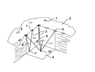
14 As described previously, and as shown in Figure 1, a seismic disturbance
is created from seismic energy sources (depicted as X's) 1 located on the earth's surface
16 2. A seismic energy ray or wave 3 is seen to travel from the source 1, down into the
17 earth to reflect from a sub-surface acoustic impedance boundary or layer 4. The energy
18 wave 3 reflects back up to the surface 2 and is detected by seismic receivers 5 (depicted
19 as circles). Equipment associated with the receivers 5 converts the received energy wave
3 into signals, and thence into recorded data, representative of sub-surface features.
2130527
One energy wave 6, travelling from a source 1, reflects at a mid-point 7
2between the source 1 and a receiver 5. This represents a one fold. Two other energy
3waves 8 and 9 are shown travelling between two discrete reflecting pairs of sources 1
4and receivers 5, each wave 8, 9 reflecting from the sub-surface layer 4 at a common mid-
5point ("CMP") 10. This represents two fold.
6Having reference to Figures 2a and 3, an arrangement of sources 1 and
7receivers 5, according to the present invention, is shown. A plurality of receiver lines 11
8are placed on the earth's surface 2 in substantially equally spaced and parallel
9arrangement. Each line 11 is formed by a plurality of equally spaced receivers 5. A
10plurality of source lines 12 are placed on the surface 2 in substantially equally spaced and
11parallel arrangement. Each line 12 is formed by a plurality of equally spaced sources 1.
12The source lines 12 and receiver lines 11 are laid out in the form of a
13rectangular grid, a portion of which forms a patch 15. A patch comprising 7 receiver lines
14is shown in Figure 7a. The spacing between the lines 11, 12, receivers 5 and sources
151 are arrived at using the following rules:
16(a) the ratio of the spacing between the receiver lines 11 and the
17spacing between the sources 1 yields a remainder greater than zero;
18(b) the ratio of the spacing between the source lines 12 and the spacing
19between the receivers 5 yields a remainder greater than zero;
2130527
(c) the source line spacing SLI and the receiver line spacing RLI are
2 established using the following formulae:
3 SLI = Rl (m + 1/SR)
4 RLI = Sl (n + 1 /Ss)
where:
6 Rl = is the receiver spacing,
7 Sl = is the source spacing,
8 SR = jS the desired number of sub-bins in the receiver line
9 direction; and
Ss= is the desired number of sub-bins in the source line
1 1 direction.
12 The values n and m are integers which affect the magnitude of the receiver
13 and source line spacing, chosen according to the number of receiver channels available
14 and the specified maximum desired size of the patch 15. Generally, a greater number
of source and receiver lines 12, 11 than the desired number of sub-bins SR~ SS are
16 required to ensure that no holes appear in a standard bin 13.
2130527
A typical grid design for the arrangement of Figures 2a and 3 would involve
2 the following values:
3 Rl = 60 m
4 Sl = 60 m
SR = 2
6 Ss=2
7 SLI = 150 m
8 RLI = 150 m
9 RLI/SI = 2.5
SLI/RI = 2.5
11 A grid design using rules (a), (b) and (c) and the typical values given above
12 yields the arrangement shown in Figures 2a and 3, wherein only every second crossing
13 A of receiver line 11 intersects a source line 12 so that a source 1 and a receiver 5 are
14 substantially coincident and only every second crossing B of a source 12 intersects a
receiver line 11 so that a receiver 5 and a source 1 are substantially coincident.
16 Seismic energy waves 3 are transmitted from the sources 1 and are
17 detected at the receivers 5. An array of reflections at CMPs 10 are produced within
18 standard bins 13. Each standard bin 13 has dimensions of 1/2 the source spacing by 1/2
l 9 the receiver spacing.
2130527
Since two reflection points are produced in each line direction, four
2 theoretical CMPs 10 appear within each standard bin 13. Therefore, for the arrangement
3 of Figures 2a and 3, the number of CMPs 10 which appear in each standard bin 13 is
4 four, fourfold that of the prior art of Figures 5a and 5b.
Having reference to Figure 4, the discrete area surrounding each CMP 10
6 within a standard bin 13 is referred to as a sub-bin 14. Therefore a standard bin 13
7 which contains 4 CMPs 10 (Figure 2) is comprised of 4 sub-bins 14.
8 The coincidental alignment of a source 1 and a receiver 5 at every second
9 or greater crossing is representative of only one, easily-portrayed arrangement.
Consistent with the rules (a), (b), and (c) above, alternate arrangements of a grid can be
11 designed as demonstrated in Figure 2b. A grid can be created in which a receiver line
12 11 and a source line 12 cross without having a source 1 and a receiver 5 in coincidental
13 alignment; resulting instead with a repeatably occurring geometry, or relative offset R
14 therebetween. In Figure 2b, a grid is shown which yields an arrangement wherein the
relative offset R between an adjacent source 1 and a receiver 5 only identically repeats
16 at every second crossing D of receiver line 11 and source line 12, and the relative offset
17 R between a source 1 and a receiver 5 only identically repeats at every second crossing
18 E of a source line and a receiver line. Other repeatably occurring relative offsets R' are
19 observed between sources and receivers which are not necessarily adjacent. Stated
otherwise, each successive crossing of a source and receiver line does not result in the
21 same relative offset between a source and a receiver. Only at every second or greater
22 crossings is a relative offset R, R' substantially identically repeated.
2130527
In the particular arrangement of Figure 2b, the spacing of the relative offset
2 R at D and E is one sub-bin width in each of the source and receiver line 12, 11
3 directions. This arrangement results in CMP spacing similar to that achieved in the
4 arrangement of Figure 2a and 3, producing 4 CMPs 10, and thus forming 4 sub-bins 14
5 within a standard bin 13. Similar arrangements can be shown to exist for any spacing
6 of the relative offset R.
7 For clarity of presentation, the remaining Figures and description refer to
8 arrangements in which the relative offset R is zero, resulting in coincidental alignment of
9 a source 1 and a receiver 5 at every second or greater crossing.
As shown Figures 5a and 5b, source lines 12 in the prior art arrangement
11 are provided perpendicular to receiver lines 11 and are overlaid thereon in a regular and
12 coincident manner at each crossing C. When seismic disturbances are created as
13 described previously, CMPs 10 are produced in an array aligned only with the sources
14 1, the receivers 5, and at array points mid-way therebetween. Therefore, each standard
15 bin 13 associated with the prior art contains only one CMP 10, located at its center.
16 The method of the invention achieves a similar fold as the prior art by
17 specifying one lines' 11 or 12 spacing slightly larger and the other transverse lines' 12 or
18 11 spacing as slightly smaller than that used for in the prior art arrangement.
19 Referring to Figures 6a through 6e, a single source line 12 is shown in areal
20 view, showing alternate arrangements for crossings of the receiver lines 11 and the result
21 upon the number of CMPs 10 produced per standard bin 13.
2130527
Figure 6a again presents the prior art case in which every crossing of the
2 receiver line 11 causes a source 1 to coincide with a receiver 5. Only one CMP 10 per
3 standard bin 13 results.
4 Figure 6b presents the arrangement according to Figures 2 and 3, in which
only every second crossing of the receiver lines 11 causes a source 1 to coincide with
6 a receiver 5. By treating the crossings of the source lines 12 in an similar manner, the
7 standard bins 13 then contain 4 CMPs 10, which is a result of two CMPs being produced
8 along each of the source and recéiver line directions (2x2).
9 Figures 6c, 6d and 6e present alternate arrangements of the present
invention in which only every third, fourth and fifth crossing of the receiver lines 11
11 respectively cause a source 1 to coincide with^ a receiver 5. The resulting standard bins
12 13 contain 9, 16 and 25 CMPs 10 respectively.
13 Generally, as shown in Figures 6a to 6e, the geometry of the crossing
14 receiving or source lines and the individually adjacent sources or receivers is only
repeated at every second or greater crossing. Not only are a receiver and a source
16 coincident at every second or greater crossing, but every adjacent receiver and source
17 at consecutive line crossings also maintain a substantially identical relative offset which
18 is repeated at each second or greater subsequent crossing. A coincident receiver and
19 source at every second or greater crossing merely have a repeating relative offset of
zero.
21
2130527
To perform a seismic survey, a sufficient number of source and receiver
2 lines 12, 11 need to be provided ensuring that enough reflecting pairs of source 1 and
3 receivers 5 are available to create sufficient fold. Figure 6f is illustrative of a situation
4 where theoretically, 25 CMPs would be produced if sufficient reflection pairs were
5 available. If in fact, only sixteen fold were achieved, then a lack of information, or "holes"
6 would appear in the standard bins 13.
7 After the seismic survey for the patch 15 has been acquired, the patch is
8 repetitively advanced to acquire data over areas greater than that immediately covered
9 by the patch. The patch 15 is advanced according to the following guidelines:
- active receivers within the patch are optimally distributed around the
11 sources which are currently selected to produce the seismic12 disturbances (ie. the sources are approximately located in the middle
13 of the patch);
14 - the patch is advanced while still retaining an overlap with the
previous location of the patch; and
16 - the arrangement of sources and receivers within the patch, and as
17 an extension of the previous patch, is consistent with the present
1 8 invention.
19 From the foregoing and using the method of the invention, it is now
20 illustrated how one may optimize between obtaining an increased fold and a more
21 detailed resolution.
22
2130527
Resolution refers to the precision with which information is known about an
2 area which has been surveyed. The greater the number of sub-bins 14, the more
3 detailed is the resolution, and the finer are the sub-surface features which may be
4 discovered.
If the signal-to-noise ratio is acceptable, one can evaluate the information
6 conveyed by each sub-bin 14 separately, resulting in a finer resolution than could be
7 achieved using the prior art.
8 If the noise is unacceptably high, then portions (sub-bins 14) of adjacent
9 standard bins 13 can be combined to produce larger bins of increased fold. The size of
standard bins can be increased in incremental, moderate steps, one sub-bin at a time,
11 until the S/N is acceptable. Typically, square standard bins 13 are re-sized into larger
12 square bins.
13 If it is determined though, that a higher resolution is desirable or needed in
14 only one direction, or in a direction oblique to the axes of the source and receiver lines
12, 11, then the sub-bins 14 can be optionally combined into rectangles oriented in the
16 direction of interest.
17 The advantages of being able to effect the fold, or the resolution in the post-
18 acquisition stage of a seismic survey, are best demonstrated in an actual example.
19 Example 1, as follows, presents seismic data obtained from a site in
southern Alberta, Canada.
2130S27
-
EXAMPLE I
2 A sub-surface reservoir was surveyed. A conservative and readily available
3 spacing Sl, Rl for the sources 1 and receivers 5 of 48 meters was chosen. This resulted
4 in a standard bin 13 size of 24 by 24 meters. Three sub-bins (SR) in the receiver line
direction and 3 sub-bins (Ss) in the source line direction were chosen, producing 9 sub-
6 bins 14 of 8 x 8m each. The total number of receiver channels was 720. A roughly
7 square patch 15 was developed using 12 receiver lines 11 of 60 receivers 5 each,
8 totalling 720 stations. Using an integer n of 5, the receiver line spacing RLI was set to
9 224 meters calculated using 48x(5-1/3). The 12 receiver lines within the patch then
encompassed (12-1)x224= 2464 meters with each receiver line length being (60-1)x48=
11 2820 meters. The source line spacing SLI was similarly calculated as 448 meters,
12 48x(9+1/3), using an integer m of 9.
13 The ratio between the spacing of the receiver lines 11 and the sources 1
14 is calculated as 224/48 = 4.67, yielding a remainder of 0.67 which is greater than zero
and not an even multiple. The ratio between the spacing of the source lines 12 and the
16 receivers 5 is also calculated as 448/48 = 9.33, yielding a remainder of 0.33.
17 Having reference to Figure 7a, the entire patch 15 of the example is
18 featured with an expanded view of one portion (Figure 7b). The relative offset between
19 a source 1 and a receiver 5 is seen to repeat at very third line crossing A, B resulting
in 9 sub-bins 14 per standard bin 13. The relative offset is seen to be zero in this case,
21 the source and receiver then being exactly coincident.
24
2130527
In this survey, a sub-surface sand formation feature 16 was located, in a
2 300 meter wide glauconite channel, which seemed to have promise as a payzone. The
3 sand feature 16 is located on Figures 14 through 18 as cross referenced by the
4 glauconite channel width marker at the top, and at a sub-surface depth as marked by an
arrow.
6 The post-acquisition technique of re-binning involves adjusting the bin size
7 to affect the fold and the signal-to-noise ratio. Fold is related to a constant times the
8 square of the bin size. Figure 8a is illustrates the squared relationship of size and fold
9 for this example. Generally, the S/N ratio is a linear relationship with bin size. Therefore
it follows that the fold can be calculated by multiplying a constant times the S/N squared
11 as shown in Figure 8b.
12 Having reference now to Figures 9 through 18, sub-bins are used to
13 advantage to more clearly distinguish the sand feature 16.
14 Referring to Figure 14, and using the original 24 x 24m standard bins 13 of
Figures 7 and 9, then about 12 seismic traces (300m/24m) define the channel width. The
16 fold achieved for this area was about 20 for the 24 x 24m standard bins. Velocity
17 information, as determined from the data for the 24 x 24m standard bins was retained
18 and used during the remaining post-acquisition, processing exercises.
19 The sand feature 16 can be tentatively identified by about 5 traces of
heightened amplitude located at the center of the channel. The results of Figure 14 are
21 basically equivalent to that which would be obtained using the method of the prior art and
22 are not generally considered as sufficient indication to initiate a drilling program.
2130527
Next, as viewed in Figure 10, the 24 x 24m standard bins 13 were re-sized
2 to larger 32 x 32m bins 17. The bin size was increased by over 30 %. Using the fold/bin
3 size constant of 0.035 (calculated from 20 fold at 24 x 24m standard bin size) and Figure
4 8a, the fold was seen to increase from 20 to about 35.
As viewed on Figure 15, although the trace data was less noisy, indication
6 of the channel width was reduced to about 9 traces wide and the sand feature 16 to
7 about 3 traces. This clearly illustrates the disadvantage to reducing the resolution, even
8 when tempered by using sub-bins to only marginally increase the bin size. The prior art
9 would have needed to double the standard bin size to 48 x 48m, reducing the resolution
of the channel width to 6 traces and the sand feature to only 1 or 2 traces.
11 As the data quality was actually quite good (S/N ratio acceptable), there was
12 an opportunity to examine the data at higher resolution. As seen in Figure 11, the 24 x
13 24m standard bins 13 were re-sized to smaller 16 x 16m bins 18. As viewed on Figure
14 16, the glauconite channel was now defined by 18 traces (300m/16m) and the sand
feature 16 by 8 traces. Referring to Figure 8a, the fold was reduced to about 8. The
16 data was visibly noisier, but not so great as to mask the sand feature 16. The resulting
17 Figure 16 bettered argued initiation of a drilling program.
18 Figures 12 and 17 present re-sizing of the standard bin 13 to 8 x 8m bins
19 19, equal in size to one sub-bin 14. The fold was correspondingly reduced to about 2.
The sand feature 16 is now defined by about 15 traces and is very distinct. It is believed
21 that the data is still acceptable because the velocity determination had been made at the
22 original 20 fold, 24 x 24m standard bin size.
26
2130527
Lastly, Figure 13a and 13b present a data averaging technique using 8 x
2 8m bins 19. Data from two adjacent sub-bins 20 was averaged to a single bin 21, and
3 the averaging was advanced one sub-bin 14. This 1x2 sub-bin sum, running average,
4 resulted in four fold data. The resultant Figure 18 presents data having less noise than
that for the direct 8 x 8m bin 19 of Figure 17.
6 In summary, as a result of the novel arrangement of sources and receivers,
7 the invention is characterized by the following advantages:
8 - the arrangements used to practice the method of the invention are
9 geometrically simple and can be performed with the standard
equipment of seismic crews;
11 - the explorationist can optimize the survey data between the
12 contrasting objectives of obtaining more detailed resolution and
13 higher fold;
14 - risks involved in guessing or anticipating the expected signal-to-noise
ratio are significantly reduced, now having improved re-sizing options
16 in the post-acquisition phase;
17 - dependent upon the signal-to-noise ratio for the data, it is now
18 possible to re-size a standard bin to a smaller size during
19 processing, improving the resolution of the survey;
- data which was particularly noisy can now be improved by re-sizing
21 a standard bin to larger size using modest sized steps, allowing the
2130~27
fold to be increased without incurring staggering reductions in the
2 resolution;
3 - dependent upon the surface geometry, the explorationist now has
4 the convenience of obtaining the same resolution by using either a
close source and receiver spacing and adjusting the line crossings
6 to produce a few sub-bins per standard bin, or a greater source and
7 receiver spacing and adjusting the line crossings to produce a
8 greater number of sub-bins per standard bin; and
9 - the explorationist can potentially secure cost savings by using fewer
channels during the acquisition phase of the survey, without incurring
11 significant risk, due to the relatively modest cost to re-process the
12 data later with slightly larger bins.
28