Note: Descriptions are shown in the official language in which they were submitted.
,.~~ 2~3~~7fi
The present invention relates to a sensor system
comprising a plurality of sensor stations for monitoring
an area intended to include an object to be protected.
The increased use of so-called "stand-off"
weapons today and presumably in the future increases the
requirement for being able to detect small targets at a
low altitude. By "stand-off" weapons are meant in this
connection weapons which can be fired at a short distance
outside the range of the anti-aircraft defence and which
autonomously steer themselves to the target. One trend is
that these weapons are increasingly utilizing the exist-
ing terrain protection. The main problem for the anti-
aircraft defence is to discover these weapons in time so
that effective countermeasures can be taken.
In current reconnaissance technology, on the one
hand radar scanners and on the other hand IR scanners axe
used. The weak points of the scanners have long been
known. With respect to radar scanners, problems caused by
radar shadows, terrain obstacles and ground clutter can
be mentioned. Terrain obstacles, low IR signature in the
forward sector of approaching missiles, low contrast and
false targets from ground objects constitute problems
with IR scanners. To cover a greater surveillance area,
information from a plurality of surveillance areas of
scanners can be collected together in a common centre.
The object of the present invention is to produce
a sensor system which is better capable of discovering
low-flying objects in time than today's systems. The
object of the invention is achieved by means of a sensor
system characterized in that the sensor stations are
distributed essentially along the periphery of a circle
in the central part of which an object to be protected is
intended to be contained, that each sensor station
comprises a detector unit which respective detector unit
is arranged to scan the arc in an azimuth sector,
allocated to it, up towards the background of the sky in
two detection fields, and that the time of the passage of
a target between the detection fields is measured in each
sensor station and the target position relative to the
sensor station is calculated on the. basis of the measured
~\. 2~32~'~
- 2 -
time, speed of the target, angle between the detection
fields and angle to the target. The individual sensor
stations included in the sensor system scan from below
and up towards the background of the sky. This avoids
interference from the surrounding terrain at the same
time as the IR area of a target increases in comparison
with the front sector of the target. By utilizing detec-
tion fields in each sensor station and measuring the time
taken for a target to pass from the first detection field
to the second, it is achieved that a target can be
detected by relatively simple means and that the target
position can be determined with good accuracy.
The position of a sensor station can be deter
mined in the grouping of the sensor station and stored in
a memory unit included in the sensor station. According
to another embodiment, the position can be determined by
means of a radio navigation system included in the sensor
station, such as GPS. Having knowledge of the position of
the sensor station and of the position of a target
relative to the sensor station, a close-range protection
weapon provided for protecting the object to be protected
can be given an unambiguous assignment of the target
position.
A target position is suitably assigned by means
of three orthogonal coordinate values related to a
coordinate system common to the sensor system as soon as
it has passed the. two detection fields. Quick coarse
assignment to a close-range protection weapon can be
carried out by sector indication as soon as the first
detection field is passed. The target position is prefer-
ably indicated as belonging to a circle sector of 360/n°,
where n equals the number of sensor stations included. In
a preferred embodiment with four sensor stations, this
coarse assignment occurs in sectors of 90°.
The target speed is advantageously determined by
means of speed measuring elements in the form of speed
measuring radar arranged in the sensor stations. By
utili2ing speed measuring radar, a value of the target
speed is obtained with great accuracy. In applications
.,. ~l~w~~~
- 3 -
with moderate requirements for the accuracy of the speed
value, an expected speed of the target on the basis of
knowledge of the speed interval within which the target
in question is moving can be used as an alternative to
measuring.
For scanning the atmosphere, detector units of
the sensor stations can comprise a line camera according
to a further advantageous embodiment.
The invention will be described in greater detail
below with reference to the attached drawings, in which:
Figure 1 shows a diagrammatic overview of a sensor system
according to the invention,
Figure 2 shows an overview of the two detection fields
associated with a sensor station,
Figure 3 shows the passage of a missile between the two
detection fields of a sensor station, with associated
measuring times,
Figure 4 shows how.flying altitude and cross-range can be
calculated, and
Figure. 5 shows a block diagram of a sensor station
included in the sensor system according to the invention.
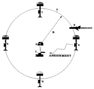
According to the diagrammatic overview of the
sensor system shown in Figure 1, four sensor stations 1-4
are included. The stations are suitably of the IR type.
The sensor stations are distributed in the terrain
essentially along the periphery of a circle 5. In the
centre of the circle 5, the object 6 is located which is
the object to be protected. In the vicinity of the object
to be protected, the close-range protection weapons 7 are
also located which will protect the object 6 to be
protected. A target which is approaching the sensor
system has been designated by 8 and can consist of, for
example, a low-flying cruise missile.
The four IR sensor stations 1-4 scan the sky in
a band above the sensors. When a target 8 with IR signa
ture passes over the area where the sensor system is
placed, this is detected by means of two consecutive
measurements which are slightly different in elevation
angle. On the basis of the two measurements, the target
. ..
-~ 213 2 ~'~
position and altitude can be calculated as described
below. It can be observed here that the positipn of a
target can already be coarsely assigned on its first
detection. The sensor system can be said to create a
"tripwire" over which an object, even a terrain-folloc~iing
object, will not be able to slip away without being
discovered. As soon as the target position has been
calculated, close-range protection weapons 7 are assigned
in three coordinates for fighting the target 8.
With the current threat picture, terrain-follow
ing missiles with speeds around 200 m/s, a "tripwire" or
circle 5 with a radius R of approximately 2 km should be
adequate. Should higher speeds come to the tore, the
radius R and the number of sensor stations included can
be increased.
Having regard to Figures 1-4, it will be shown
below how the position of a target is determined and
allocated to the close-range protection weapons 7.
As can be seen from Figures 2 and 3, a IR sensor
station 1-4 scans the space in a first and a second
detection field 9,10. The angle between the two detection
fields has been given the designation a and is known. At
time To, the target 8 passes the first detection field 9
and at time T1 it passes the second detection field 10.
The time T of passage between the detection fields is
given by the expression:
T = Ti - To
When the time of passage is known by measurement
and the angle a between the detection fields 9,10 is
known, the slant range of the target passage Altitudet,mp,
see Figure 3, can be calculated under the assumption that
the target speed V~"11, can be estimated or measured. A
speed measuring radar can be used for measuring the
speed. The following relationship can be set up:
Altitudetemp = ( T * V~e,il,1 / tan ( a ~
'~ ~13~~7u
_ 5 -
On the basis of the slant range of the target
passage and the angle p to the direction of detection 18
according to Figure 4 in which the detection occurred,
the flying altitude "Altitude" of the target and the
cross-range "Cross" relative to the sensor station cari be
calculated according to the following:
Altitude = Altitudet,mp * sin ( p )
Cross = Altitudet~ * cos ( (i )
The cross-range which is calculated lies along
the bent detection field of the sensor station which is
why the range must be converted to a Cartesian distance
relative to the sensor station. The target position
relative to the sensor station can now be calculated
according to the following:
Targetx = R * sin (Cross/R)
TargetY = - R * cos (Cross/R)
Targetx= Altitude
Assignment to the close-range protection weapons is
obtained on the basis of the position of the sensor
station and calculated target position according to the
following relationship:
Assignmentx = SensorposX + targetX
Assignments = Sensorposy + targets
AssignmentZ = SensorposZ + targetZ
The sensor positions are obtained from a storage
medium in which the position of the sensor station is
stored after the position has been measured within the
grouping of the sensor station.
Figure 5 shows an example in block diagram form
of how a sensor station can be configured. .
A detector unit 11 is arranged to operate in an
azimuth sector of 90 degrees along the arc of the circle
~~~z~7
-6-
5. With a circle with a radius of 2 kilometres, this
implies that the greatest distance at which a detector
unit can see a target is 1571 m. Each detector unit scans
the atmosphere 180° above along the arc on its quadrant.
The detector unit operates in two different detection
fields 9,10 each of which feeds its detector array 12,13.
A line camera operating close to the infrared range is
advantageously used in the detector unit. In comparison
with a scanning camera, the line camera exhibits the
advantage of maintaining continuous surveillance. At the
short detection ranges in question a good probability of
discovery is also obtained against targets which are only
aerodynamically heated. If a line camera with 1024
picture elements is used, a resolution of 180°/1024
pixels, that is to say 0.18°/pixel is obtained. This
implies that a pixel corresponds to 4.9 m with a radius
of 2 km at the greatest distance.
The detector unit 11 is waiting for a signal from
the detection field 9 which is located outside the circle
5 or "tripwire" which corresponds to the detection field
10. When the detection field 9 detects a target, a timer
14 is started. The timer is stopped when the target
passes the detection field 10. This measures the time of
passage T of the target. At the same time as a target is
detected by the detection field 9, a speed measuring
radar 15 is started which measures the speed of the
target V~"ila. A memory unit 16 stores the position of the
sensor station which is measured at a previous time in
the grouping of the sensor station. The memory unit can
also store the value of the angle a between the detection
fields 9,10. On the basis of the information which is
provided by the detector unit 11, the timer 14, the radar
15 and the memory unit 16, a calculating circuit 17 can
calculate the target position in correspondence with the
relation shown earlier. After the calculations have been
carried out, protection weapons are assigned to a target
position x, y, z with very high accuracy.