Note: Descriptions are shown in the official language in which they were submitted.
2~387~
1506-001 CA
SYSTEM FOR MAPPING OCCURRENCES OF PREDETER~INED
CONDITIONS IN A TRANSPORT ROUTE
Technical Field
The present invention relates generally to monitoring
conditions with respect to cargo on transport routes, and
more particularly to a system for mapping the occurrence
of predet-~rm; n~d conditions as detected by vehicles in
real-time along such a tran6port route.
Backqround Art
Damage to freight due to rough hiln~ll in~ and road
conditions is a costly situation. Rough handling can be
caused by slack action within a train transporting
freight, usually due to poor train hAn~l in~ or by coupling
cars at excessive speeds. Rough h~n~l1 in~ and
irregularities along the transport route create additional
expenses by forcing shippers and customers to make
considerable expenditures on blocking, bracing, and
otherwise attempting to cushion the freight being
transported. It is necessary to track instances of rough
cargo h~n~l in~ and irregular transport routes to take
appropriate measures to protect the cargo.
21~3g7~
One system for monitoring conditions under which
rough hAntl 1 i n~ may be a problem is the use of hand-held
radar for measuring coupling performance with respect to
freight cars. This measuring system has several flaws.
First, the radar operators are in plain view of the switch
crews. Consequently, their normal performance may be
altered. Second, there are not enough personnel to
constantly monitor coupling speeds for the many freight
cars required to be handled in order to ensure good
coupling ~ractices twenty-four hours a day, seven days a
week. Further, the use of hand-held radar is typically
dangerous and requires one person to make the readings and
another to record them. This system is also inadequate
f or use along an entire transport route in which
irregularities along either a rail route or paved road may
contribute to cargo damage.
One proposed solution suggests the use of monitoring
modules losated on the vehicle itself for collecting and
storing information. Such a system is described in U. S.
Patent No. 5,01~,206 to Scribner et al. In this system
the location of a vehicle is detr~rm; nf~l and recorded
during the occurrence of events detected by sensors which
respond to such an occurrence. The system is associated
with navigational units to receive positional information
from a navigation system. The location of the vehicle is
stored in a data collector on the vehicle. The date and
~387~
.
time of the events may also be stored along with the
positional information. The position is det~rmin~d by
means of a navigation system such as GPS or LORAN. The
stored information is later transported to an information
delivery point and downloaded to a data processing system.
Here the information is analyzed to determine the exact
location and time of the occurrence of the events, such
the closure of a passenger door of a taxi or bus, or the
pickup of waste by a truck.
As illustrated in Figs. 1 and 3 of Scribner et al., a
truck 10 is e~uipped with a lift arm sensor 18 and rear
door sensor 24 which are coupled electrically to a
navigational system such as a GPS type system. The truck
also has a passive radio transmitter in the form of tag 30
mounted on it. One such tag is described in U. S. Patent
No. 4, 688, 026 issued to the same inventors . The purpose
of this transmitter is to transmit the truck
identif ication number to a base data receiver/computer
unit 32 which may be located at the depot where the truck
is returned and housed. When the truck leaves the depot,
an RF signal from the receiver/computer unit 32 causes the
tag 30 to transmit the truck identification to the
recèiver/computer 32. The receiver/computer records the
time, date and truck identif ication number . On returning
to the depot the tag 30 again transmits the truck
identification number to the data receiver/computer unit
214387~
32. The information contained in the data collector 28
may then be downloaded into the bàse receiver unit 32.
This information may consist of (l) the identification
number of the truck, (2) the day, time, latitude and
longitude of each occurrence of the lift arm actuating its
sensor, and (3) the day, time, latitude and longitude of
each occurrence of actuation of the rear door sensor.
In order to properly protect cargo, the acceleration
to which the cargo is sub~ected must be carefully
controlled. U. S. Patent No. 4,745,564 to Tennes et al.
describes an impact detection apparatus for measuring and
recording acceleration or other physical quantities
experienced by easily damaged items of commerce such as
fruit, or electronic computers. A triA~ accelerometer
or other suitable sensor produce6 signals which are stored
in a memory along with the times of the events which
trigger the accelerometer. ~his provides an event-time
history which later may be read from the memory for
analysis after the hAnf~l ;ng or transportation is
completed.
Control of the acceleration to which cargo carrying
vehicles are sub~ected can be exerted as described in U . S .
Patent No. 5,129,605 to Burns et al. This document
describes a vehicle positioning system using ~ plurality
21~38~5
of inputs such as a GPS receiver, wheel tachometer, O . S .
circuits, transponders and manual inputs f rom locomotive
engineers .
Systems exist for continuously establishing and
indicating the location of vehicles such as cars, trucks
and boats. Such a system is described in U. S. Patent No.
4,884,208 to M~r;nr~lli et al., which is directed primarily
towards theft prevention. In this system a master
tracking 6tation receives and stores signals
representative of the ob~ect identification and the
location of the object, and may provide a visual
indication of the object identification code and object
location. Only vehicle location is detected.
The occurre~ce of events along a transport route is
mapped out in U. S. Patent No. 4,793,477 to Austill et al.
However, this system does not include the use of a
transmitter, from which information is downloaded into a
central controller via a communication system. Nor is
location information fed into a sensing module on the
vehicle. Rather, the event location is determined by
sensing and recording the degree and direction of track
curvature for the rails on which the vehicle is
travelling .
~one of the aforementioned conventional systems
provides the necessary attributes to map, in real-time, a
cargo transport route with respect to conditions occurring
21~3875
on that route which may af f ect the cargo . In order to
properly protect the cargo travelling along a route, it is
necessary to have a timely knowledge of all conditions
which might affect the cargo along that route. Such
conditions can be natural or man-made, transient or steady
state, and can be caused by interaction with other
vehicles or individuals, or by the physical condition of
the transport route itself. For such a system to be
widely used, it must be ef f ective f or a variety of types
of transport routes, and be able to supply information
regarding all the parts of a given transport route over
long distance~. Such information should be immediately
available upon request or the occurrence of an event of
interest (affecting transported cargo) along the transport
route. Further, overall conditions along the transport
route with respect to such occurrences should be recorded
for display and easily updated. The information should be
immediately available over long distances without having
to approach each vehicle carrying the means for sensing
the occurrence of conditions of interest.
Disclosure of the Invention
One ob~ect of the present invention is to provide
timely mapping of entire cargo transport routes with
respect to conditions impacting cargo being transported
along those routes.
21~387~
Another object of the present invention is to
periodically trigger information regarding transport route
conditions in a timely fashion so that it is possible to
have real-time knowledge of conditions which impact upon
cargo beLng transported along a particular transport
route .
Yet another object of the present invention is to
determine transport route conditions and the events along
that route impacting upon cargo in a specif ic vehicle
without having to approach that vehicle.
A further object of the present invention is to
maintain a current record of a particular cargo transport
route for immediate display upon request by a user remote
f rom the storage location at which the transport route
data is correlated and stored.
Still a further object of the present invention is to
provide a system in which the location of a particular
vehicle and the condition of its cargo can be accessed by
a remote user upon demand.
These and other ob~ects are accomplished using a
method of mapping the occurrence of predet~inf~d
conditions along a transport route travelled by a mobile
sensing station connected to a central controller via a
f irst communication system. ~he mobile sensing station
continuously senses for the occurrence of the
predetf~rmi ned conditions along the transport route . When
21~3~7~
these conditionx are detected, data regarding these
conditions are stored, as well as time and date data
corresponding to the sub~ect occurrences. Positional data
is also received and correlated with the occurrence. The
mobile sensing station is then triggered to transmit the
correlated data over the communication system to a central
controller. The correlated data is arranged so that a map
of the transport route can be displayed, showing the
locations of the predetPrmi ne-l conditions .
In a second embodiment of the present invention a
system is used which includes at least one mobile sensing
station mounted on a vehicle traversing a given transport
route, a first ~l ; r~tion system, and a central
controller. The mobile sensing station includes means for
continuously detecting occurrences of predet~rmi n~l
conditions along the transport route, means for receiving
or detecting positional data, means for storing data,
characteristics of the occurrences detected, as well as
time and date data corresponding to each of the
occurrences, means for correlating the positional data
with corresponding occurrences of prede~Prrni n~
conditions, and f irst means f or transmitting the
correlated data in response to a triggering condition.
The central controller includes means for receiving the
correlated data via the first communication system, and
means for displaying the correlated data so as to identify
21~387~
positions along the transport route at which the
occurrences of the prede~ormi n~l conditions are detected.
These and further ob~ects and advantages of the
invention will become more apparent upon reference to the
following description, drawings and claims.
Brief DescriPtion of the Drawinqs
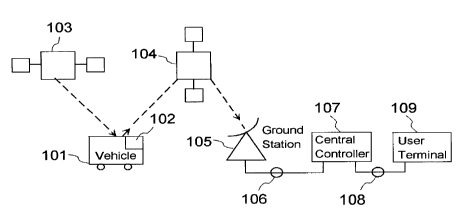
Fig. 1 is a diagrammatic illustration of an outline
of the overall system of the invention.
Fig. 2 is a block diagram illustrating the elements
contained in a mobile sensing station for one preferred
embodiment of the present invention.
Best Mode for Carrvinq Out the Invention
Fig. 1 illustrates the general layout of a system for
effectuating the present invention. A vehicle 101,
usually transporting cargo, moves along a transport route.
The route can be one that is well known, or it can be one
that is being newly travelled by the vehicle. The vehicle
carries at least one mobile sensing station 102, which
f unctions to detect predetermined events or conditions
(such as collisions or impacts, potholes or uneven tracks
or the like ) along the travel route, and transmit data
regarding those conditions via orbiting satellite 104 to a
remote ground station 105. The ground station transfers
the data from the mobile sensing station to the central
` ~ 21~387~
controller 105 through data link 106. A user t~rrnin~l 109
can access data in the central controller via
communications link 10 8 .
Part of the data transmitted from the mobile sensLng
station is positional data received or detected from a
satellite 103 which is part of a satellite navigation
system. Examples of presently available systems are LORAN
or the current Global Position System (GPS).
Preferably navigational data sent to the mobile
sensing station utilizes a Standard-C data protocol
format, which is commonly used in the maritime industry.
Experience has indicated that this is the most reliable
method of sending navigational data from one mobile
station to another.
Xowever, other navigation or location systems can be
used. For example, a series of radio repeaters located
along a prede~rm; nr~ route can track the location of a
specific vehicle and can be used to send location data to
the mobile sensing station 102 as is done by satellite 103
in Fig. 1. Also, other data transfer formats can be used,
depending on the navigational system, the transport route,
the vehicle and the communication system for transmitting
data from the mobile sensing station to the central
controller .
While Fig. 1 illustrates an uplink from the mobile
sensing station to a satellite, the mobile sensing station
'- 21~387~
11
can communicate with the central controller by means of a
cellular telephone system. In this variation, a standard
base unit is sub6tituted for ground station 105, and the
mobile sensing station carries a cellular transceiver
capable of automatically acce6sing base stations as it
passes from one cell into another. While such equipment
may be more complex and expensive than the satellite
uplink embodied in Fig. 1, it facilitates easy
communication of instructions from the central controller
to the mobile sensing station . The immediate trAn~m; ~sion
of such instructions may not always be easily facilitated
with currently available satellite systems although such
immediate acce3s will be available upon completion of
presently planned installations.
The central controller 10~ stores the data sent from
the mobile sensing station and arranges it so that it can
be used in a display indicating the occurrence of
prede~rmin.od conditions along the route travelled by
vehicle 101. The central controller is expected to handle
data from a variety of routes, each travelled by a
plurality of vehicles having mobile sensing stations.
Data regarding specific transport routes or specific
vehicles can be accessed over a communications link 108 by
~ user ~r~rm1nAl 109, remotely located from the central
controller. Since the data is transmitted from the mobile
sensing station in ASCII format, the user ~f~rmin~l can
;~ 38~5
12
access selected data from the central controller using a
personal computer (pc), a modem and the appropriate
software. With the appropriate software a display of the
desired transport route can be generated at the PC
t~n; n~ l, and the conditions along the transport route can
be updated as inf ormation i~ received f rom various
vehicles having mobile sensing stations travelling along
that route.
It is noted that although one mobile sensing station
102 is illustrated on vehicle 101, more than one sensing
station can be used on each vehicle depending upon the
conditions to be detected. Vehicles of extended length
such as tractor trailer arrangements or railroad trains
can have mobile sensing stations located at various points
along their length to monitor specific rh~n~ ~ occurring
with respect to the vehicle8 as they pass along the
transport route.
Fig. 2 illustrates one example of a mobile sensing
station 201. Antenna 202 is used to receive navigational
data from a navigational system such as LORAN-C. The data
is demodulated in receiver 203 so that it can be stored
and/or operated on by proce8sor 205. The navigational
data is correlated with the appropriate occurrences of the
prede~rmi n~rl conditions detected by sensor module 204 .
The processor also correlates time and date information to
21438~
13
the appropriate data corresponding to the occurrence of
predet~rm; n~l conditions detected along the transport
route .
Sensor module 204 can be of a single sensor type or
of a plurality of different types connected so that
indication of a variety of predet~rmi n~l conditions can be
transmitted to processor 205. The sensor modules can be
located as part of the mobile sensing station package or
can be remotely located throughout the vehicle. The
sensors can be used to detect a variety of different
vehicle conditions, transport route conditions, and cargo
conditions. In one embodiment, the sensor module includes
an accelerometer capable of three-axis measurement of
acceleration vs. time. In many cases, this is the only
sensor data that is needed to determine if transport route
conditions are appropriate f or the cargo being
transported .
After correlating the location data from receiver 203
and the sensor 204, data processor 205 sends the
correlated data to transmitter 206 which transmits the
correlated data to the satellite 104 via antenna 207. It
is a feature of the invention that a transceiver can be
substituted for transmitter 20`6 so that the satellite
6ystem can accommodate tr~nRm; ~sion of data from satellite
104 ( in Fig . 1 ) to the mobile sensing station . One such
system capable of providing such operation is the
21~3875
14
satellite communication system operated by American Mobile
Satellite Corporation, through its subsidiary, Al!ISC
Subsidiary Corporation, which may be used to facilitate
one embodiment of the present invention.
In one illustrative embodiment wherein a three-axis
accelerometer is used, the system has the capability of
recording acceleration transients on each measurement axis
which exceed a f actory preset value of 3Gs as a trigger
threshold, and which occur within a 256 millisecond time
window. The system records the highest acceleration level
reached during this time window, and the exact date and
time at which it occurred. The system continues to
operate in this fashion until either it has accumulated a
total of 248 peak readings or is interrupted for data
download by a remote host t~rm; n~ 1 such as the central
controller 107. This particular version of the mobile
sensing station may be constituted by a ride recording
device such as or similar to the environmental data
recorder manufactured by Instrument Sensor Technology in
Lansing, Michigan. The accelerometers in this type of
device have a measurement range of 0 to + lOg, and a
resolution of i . 04g . The mobile sensing station is
preferably provided with a standard RS-232 serial
communication interface with command protocol supplied for
customer integration with the host t~rm;n;~l computer for
control and data transfer.
21~387~
While the mobile sensing station 201 may be triggered
aE described in the previous paragraph, other modes of
triggering may also be accomplished. For example, the
transmission of data can be triggered by a single
occurrence of the predet~rmin.o~ conditions, or by some
combination of conditions. Triggering may also occur
periodically regardless of the number or types of detected
predetPrmi n~d conditions . In the embodiment wherein a
transcelver is substituted for transmitter 206 and the
communication system between the central controller and
the mobile sensing station provides continuous
communication, a control signal from the central
controller may be transmitted to antenna 207, received by
transceiver 206, and used to trigger processor 205.
It is not necessary that the location data be
transmitted at the same time as the data regarding the
occurrences of the predetermined conditions. Under some
system conditions, data regarding the occurrence of the
predeterm~ n--d conditions may be sent as soon as the
triggering operation occurs, and a proximity position
report may follow within a few minutes. I'he coordination
between the two types of data may be ad~usted by processor
205 ~based upon system parameters and other operating
requirements as are necessary to provide a real-time data
input of transport route conditions. For example, the
second-by-second correlation of positional data with data
21~387~
. ~
16
regarding the predetermined conditions is not critical in
a railway switching yard since the vehicle spends a
substantial amount of time in the same location while
being switched. On the other hand, a vehicle travelling
at high speed along a transport route which may be
unfamiliar will require positional data to be closely
correlated with that of the prede~Prm~nf~d conditions
detected along the transport route.
Although a number of arrangements of the invention
have been mentioned by way of example, it is not intended
that the invention be limited thereto. Accordingly, the
invention should be considered to include any and all
configuration, modifications, variations, combinations or
equivalent arrangements falling within the scope of the
following claims.