Note: Descriptions are shown in the official language in which they were submitted.
CA 02149196 1995-07-10
~'.! ~ '
- 1 -
LOCATION DETERMINATION USING VECTOR MEASUREMENTS
The present invention relates to a method
of determining from a measurement region, the
location of a source of a physical phenomenon.
The invention is particularly suitable for
applications where the source is "invisible" from
the measurement location such as subterranean
ranging. The measurement region could be a well
borehole being drilled and the source could be an
adjacent well borehole.
Nowadays, it is common practice in oil and
gas extraction and exploration for a well to be
drilled in the vicinity of an existing well.
Sometimes it is desired that the well being drilled
should communicate with the existing well. In other
applications it is important that the paths of the
two wells should not cross. Either way, it is
necessary to determine when the path of one well is
approaching the path of an adjacent well.
Various techniques have already been
proposed for estimating the direction and distance
away of an adjacent well. Some of these are
so-called "active" techniques which involve causing
a signal, such as an electric field, to be generated
in the adjacent well which is measurable from the
well being drilled. Other so-called "passive"
techniques measure other phenomena already available
from the existing or "target" well such as magnetic
interference due to metal parts in the target well.
Most of these earlier techniques are complicated in
terms of the measurements they require for ranging
the target well and do not always produce accurate
results.
It would therefore be desirable to provide
a simplified technique for subterranean ranging.
CA 02149196 1995-07-10
.~ t>,' ,'
2
The present invention provides a method of
determining from a measurement region the location
of a source of a physical phenomenon comprising
detecting the direction of the phenomenon as a
vector at at least two spatially separated points in
the measurement region and finding a line which is
intersected by the lines including said vectors.
In the preferred embodiment of the
invention, the physical phenomenon is a magnetic
field. A drilled well usually contains some
magnetically permeable material such as a metal
liner extending along the borehole or possibly a
drillstring itself. The metal influences the
magnetic field which would normally act on an
adjacent well (ie: the earth's magnetic field).
This influence is generally referred to as "magnetic
interference". The metal in the borehole typically
behaves as a cylindrical bar magnet having the
typical magnetic field pattern extending around it.
The field strength decreases with distance from the
borehole. The magnetic interference due to the
metal in the borehole can be measured as a vector
whose orientation depends on the location of the
measurement point within the magnetic field. The
present invention is based on the realisation that
if a cylindrical bar magnet, or in this case the
borehole, is viewed "end on", ie: looking down the
borehole, the magnetic field vectors appear to
intersect at a particular point. In other words,
the magnetic field lines all intersect the
longitudinal axis of the borehole.
Thus, a line intersected by all detected
magnetic field vectors represents the longitudinal
axis of the source of magnetic interference.
Knowing the location of the longitudinal axis, the
minimum distance between a well being drilled and an
CA 02149196 1995-07-10
y ; )
- 3 -
adjacent borehole can be determined.
In more general terms, knowing the
location of the longitudinal axis of a source of a
phenomenon enables an approximate determination of
the distance of the source from the region where the
measurements are being taken.
If the azimuth and inclination of the
source is already known, its position can be
determined from only two measured vectors. If only
one of azimuth and inclination is known, three
vectors will normally be sufficient to determine the
position of the axis of the source with reasonable
certainty. If the azimuth and inclination are not
known, at least four vectors will be needed to
determine the position of the axis of the source
with any certainty. (There are an infinite number
of straight lines which will join three spatially
separated straight lines but it is unlikely that
more than two straight lines will join four
spatially separated straight lines, one being the
measurement line, the second being the target line.)
For greater accuracy it will be preferable to take
more than only three or four vector measurements
even with prior knowledge of one or more the
borehole parameters. Then, allowing for errors, the
longitudinal axis of the source will be the line
which is most nearly intersected by all of the
measured vectors.
In the case of a well borehole,
measurements would be taken at various positions
along the borehole.
It should be noted that according to the
present invention it is not necessary to measure the
magnitude of the phenomenon, only its orientation.
Other measurable phenomena which may be used for
source ranging include shock waves, sound waves,
CA 02149196 1995-07-10
1 r T
.,
- 4 -
heat waves and electric fields. The only essential
criterion is that the phenomenon should be
"directional".
Other known ranging techniques which use
magnetic field measurements require more detailed
measurements, such as the magnitude and/or gradient
of the magnetic field. In the present case it is
not even necessary to know whether the interference
field acts towards or way from the adjacent well.
A method of borehole ranging according to
the invention will now be described by way of
example only and with reference to the accompanying
drawings in which:
FIGURE 1 illustrates the relationship
between the path of a borehole from which
measurements are taken, the path of an adjacent
borehole, and measured magnetic interference
vectors;
FIGURE 2 illustrates the magnetic field
lines from which the vectors are derived;
FIGURE 3 shows the vectors extended;
FIGURE 4 corresponds to Figure 3, omitting
the field lines;
FIGURE 5 shows the same features as Figure
4, viewed instead along the line of the adjacent
borehole;
FIGURE 6 shows the same features as Figure
4, viewed instead along the "measuring" borehole;
FIGURES 7 and 8 show how the displacement
can be calculated once the line of the adjacent
borehole is known;
FIGURE 9 shows a practical example of
typical vectors which would be measured at different
locations down a borehole as an adjacent well is
approached; and
CA 02149196 1995-07-10
j ~*;)~ } ~~
- 5 -
FIGURES 10, 11 and 12 are mathematical
diagrams used in the explanation of the
transformations which may be used to mathematically
solve the target line.
FIGURES 13a and 13b are diagrams to
demonstrate that three vectors are insufficient to
calculate a target line.
Well ranging using the method of the
invention does not require any special equipment. A
typical downhole survey tool is typically provided
with three mutually perpendicular fluxgate
magnetometers for measuring flux components to
generate a flux vector, and three accelerometers for
taking measurements of the gravitational field at
different locations down the borehole. These are
usually provided in a single sensor package and
sensor information is stored to memory or
transmitted to the surface using MWD (measurement
while drilling) techniques, or via a wire link. As
already briefly noted above, the interference from
the metal in an adjacent well is normally from the
tubular elements within it, eg: casing, drill pipe,
collars etc. The interference surrounding them is
determined by the magnetism (induced and permanent)
within the metal. The shape of the interference
pattern is determined by the homogeneity of the
magnetism and the shape of the metal.
It is normally the case that the magnetism
is homogeneous within a joint of a casing, drill
pipe or collars and their shape is normally
rotationally symmetrical and tubular. The effect of
this on the interference pattern is that it has a
sense of symmetry looking down the longitudinal axis
of the cylinders. The technique of the present
invention makes use of this symmetry.
CA 02149196 1995-07-10
~?i~+';~;w,
- 6 -
Objects in a well such as pipe sections
etc. are often screwed together to form a long
continuous cylinder. There may be parts of
cylinders inside each other and other combinations
of components. However, the longitudinal axis of
these items lies along the wellbore path. Thus, the
origin of any magnetic interference from a borehole
may generally be considered to originate in
cylinders in the target well. The magnetic field
emanates from the cylinders as if they were
cylindrical magnets.
Under normal conditions the magnetometers
of a downhole tool will detect the earth's magnetic
field. In the vicinity of another well they will
also detect the interference field. In order to
determine the interference vector at any point
downhole, first the normally present earth's
magnetic field must be subtracted as will be
explained in more detail below.
FIGURE 1 shows the relationship between
the path M of the borehole being drilled
(measurement line), the line of the adjacent
borehole T (target line) and the calculated
interference vectors 1-7 measured at various points
a-g along path M. The illustrated interference
vectors are due solely to interference from adjacent
borehole T. In other words the earth's field and
other interference to be described below has been
subtracted from the measured values.
Figure 2 additionally illustrates the
magnetic field lines, due to "cylindrical magnets"
in the target well, which cause the interference.
The measured vectors are tangential to the field
lines.
CA 02149196 1995-07-10
:;
C j t~. y~ .~ ,, l
_ ? _
Figure 3 shows the interference vectors
extended (shown as dotted lines). As noted above,
the magnitude of the vectors does not need to be
known. Thus, in this technique, each vector is
extended to an infinite line in space.
Viewed in the plane of Figure 4 (or
Figures 1 to 3 ) the lines including the vectors 1-7
appear to intersect at random points in space. If
the view point is changed and the lines are reviewed
looking down the target line T, the vectors appear
to intersect at a common point. The plane of Figure
5 is perpendicular to the target line and the lines
including the vectors all cross the target line T.
It should be noted that the lines
including the vectors also cross the measurement
line M, as shown in Figure 6 in which the
measurement line M is parallel to the plane of the
paper. Thus the lines including the vectors are a
special set which all cross two lines, T and M.
The position of M is known and therefore
the position of T can be found using techniques to
be described below. If no information is available
on the spatial location of T, at least four vectors
will generally be needed to determine the azimuth,
inclination and displacement D of T from M, as
shown, for example, in Figure 9. If a parameter of
the target line is already known, such as azimuth,
inclination or direction, generally only three
vectors will be required as shown in Figure ?,
although in special cases (e. g. parallel vectors)
will not give the required information.
Approximation techniques would be used, as explained
later on. If the azimuth and inclination are already
known, a solution for T can be found with only two
vectors, as indicated in Figure 8.
CA 02149196 1995-07-10
r '
-
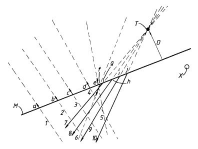
Figure 9 shows a practical example of a
drilling operation with the interference vectors
typically measured at various points a-j along the
measurement line. Lines 1-10 are the extended lines
which include the linear interference vectors.
Lines 1-5 are extended from interference
vectors measured at points a,b,c,d,e along the
measurement line M. At these points there is no
appreciable influence from the target well T. The
interference vectors at points a,b,c,d,e have been
corrected for the effects of the earth's magnetic
field and are simply due to inter:Eerence from the
drilling drillstring itself and :inherent errors.
For example, it is assumed that the measurement line
follows a straight azimuth but there may in fact be
slight deviations which will cause errors.
At point f on measurement line M,
interference from the target well is detected and
the vector extended to line 6 is due to drillstring
interference, inherent errors, plus interference
fram the adjacent well. As drilling approaches the
target well the interference becomes more marked.
Lines 7,8,9,10 are extended from vectors which have
been corrected for drillstring interference and
inherent errors and are solely due to interference
from the target well. As shown, all of the lines
cross the axis of the target well which is
perpendicular to the plane of Figure 9. Figure 9
also shows the position K at which the target well
was thought to be using a gyro surveying technique.
In practice, normal surveys (readings)
might be taken every 30 feet along a borehole. At
the first indication of interference from an outside
source it would be appropriate to reverse the tool
and take additional readings between the last and
present position. This will enable analysis of the .
CA 02149196 1995-07-10
- g -
position of the source of interference so that
corrective action can be taken.
It should be noted that the magnetic
interference can come from anywhere on the target
well, it can leave the target well at any angle, and
can be of any strength. It is the particular shape
of the field which enables the source to be
identified using the method of this invention.
The following describes some of the
mathematics involved in the determination of the
interference vectors and eventual calculation of the
adjacent borehole location.
As noted above the drilling tool has three
mutually perpendicular fluxgate magnetometers which
produce measured values Hx, Hy, Hz, (x,y,z being the
axes of the tool coordinate system) and three
mutually perpendicular accelerometers which give
gravitational measurements Gx, Gy, Gz.
Firstly it is necessary to calculate the
values which would be detected by the fluxgate
magnetometers if there was no interference present.
This can be done using the values of Gx, Gy and Gz,
the total earth's magnetic field intensity, Ho, and
the magnetic dip 0 which are known and the azimuth
AZ of the measurement line which can either be
measured or assumed on the basis that the
measurement line is straight.
From Gx, Gy and Gz the inclination (INC)
and the gravity tool face (rotational position of
the tool) (GTF) can be derived from the following
equations:
INC - ATAN (Gx + Gy2),/Gz (1)
GTF - ATAN (GX) (2)
(Gy)
CA 02149196 1995-07-10
~' I ~+ '~ ~' ' , ,
- to -
Then, the values of H which would be
expected with no magnetic interference can be
calculated as follows:
Hxc = Ho COS 0. SIN AZ. COS GTF + Ho COS O.
COS AZ. COS INC. SIN GTF -
Ho SIN O. SIN INC. SIN GTF (3)
Hyc = Ho COS D. COS AZ. COS INC COS GTF -
Ho SIN D. SIN INC. COS GTF -
Ho COS O. SIN AZ. SIN GTF (4)
Hzc = Ho SIN O. COS INC + Ho COS D. COS AZ.
SIN INC. (5)
The interference vectors can then be
calculated as follows:
Hxerdi - Hx - Hxc
Hyerdi - Hy - Hyc
Hzerdi - Hz - Hzc
where 'er' represents inherent errors, 'd'
represents drillstring errors and 'i' represents
outside interference.
It is usually convenient to transpose the
vectors to the "world" coordinate system from the
tool coordinate system using standard mathematical
techniques which are readily available to those
skilled in the art. However, where all that is
required is a measurement of displacement relative
to the drilling tool, this is not essential.
CA 02149196 1995-07-10
~~ i'~
- 11 -
Having calculated values of HXerdi~ Hyerdi
and HZerdi~ the 'er' and 'd' components need to be
separated to give the 'i' (outside interference)
components. Usually the 'er' and 'd' components are
constant or consistent and only the 'i' vector
changes and therefore calculation of the 'i' vector
is a simple matter of subtraction.
If the measurement line is approaching the
target line from a distance greater than the range
of influence of the interference (as shown in Figure
9) then the initial vectors will consist only of
'er' and 'd' and can simply be subtracted once the
'i' factor comes into play.
In rare instances the measurement line may
be parallel to the target line or tangential to one
of the magnetic field lines, in which case the
interference vector may not change at different
locations along the measurement line, and no
realistic determination of the position of the
target line can be made. In such unusual cases the
problem can be overcome by changing the measurement
line direction slightly.
There may be situations where "i" is
always present and it is not possible to simply
calculate the factors "er" and "d" from previous
measurements. In such cases it may be possible to
calculate the contributions to the vector
measurements due to "er" and "d" using mathematical
techniques. Alternatively, drillstring interference
"d" could be eliminated or reduced to an
insignificant level by isolating the survey
instrument, eg: distancing the survey package from
steel within the measurement well or simply using a
non-magnetic material in the measurement well.
Inherent errors "er" can be removed by using a
survey device to measure the azimuth which is not
CA 02149196 1995-07-10
,.
- 12 -
reliant on the magnetic field, such as a gyro.
Having determined the interference vectors
the next step is to find the viewing plane at which
the lines including the vectors appear to cross, as
shown in Figure 5. At the experimental stage of the
invention, this has been done very simply using a
3-D CAD system and changing the viewing angle or
viewing plane to find the plane in 'which the vectors
appear to cross. However, it is anticipated that a
computer program could be produced to do the finding
automatically, possibly by an interactive process.
Of course there will be errors in the calculation of
the vectors and it will be a case of identifying the
"best fit" as the target line. The best fit might
be the line which all vectors approach most closely,
which can be calculated by the program.
Once the target line has been determined,
and knowing the coordinates of the measurement line
from the survey tool, it is a straightforward
mathematical calculation to determine the minimum
distance between the two lines, equivalent to the
displacement D between the two boreholes.
Hereinafter follows an explanation of the
mathematics involved in finding the "best fit" for
the interference vectors, with reference to figures
10, 11 and 12. It is shown in Figures l3a,b
that three vectors are not sufficient in general to
unambiguously define a target line.
Given three arbitrary vectors a, b and c
passing through a line M (Measured line), and three
lines A, B and C representing the infinite
extensions of the vectors a, b and c respectively,
we wish to find a line T intersecting A, B and C.
Suppose a point is chosen arbitrarily on
line A, referred to as al, and a line is then
extended from al to any point on B, there is an
CA 02149196 1995-07-10
! i~ '~ .i , ; :.
- 13 -
infinite choice of lines, all of which lie in a
plane containing al and B (see Figure 13a), which we
call plane P1. It is evident that any point in Pl
lies on a line from al to a point on B (except
points on a line from al in direction b). Line C
also passes through plane Pl (unless it is a special
case and runs parallel to Pl) at a point referred to
as cl.
It is therefore clear that a line can be
extended from al through cl (in plane P1), which
must also at some point pass through B, at a point
referred to as bl.
This line therefore passes through A, B
and C and therefore satisfies the requirement for T.
However, this line T is not unique as the
point al was chosen; there are an infinite number of
possible choices for point al (a2, a3....) giving
rise to an infinite number of possible lines T (Tl,
T2 . . . ) . Thus T is not unique ( see Figure 13b for an
example of another line T2), and it is
straightforward to show that there are always lines
Ta and Tb which could be at an angle to one another
of between 0 and 90 degrees.
At least 4 vectors are therefore needed to
get a fixed line T representing the borehole to be
located. Mathematically, there is an infinitely
small chance that there will be no solution,
equivalent to the probability that three vectors
will be linearly dependent. It is very probable that
there will be one or two solutions, and again
infinitely unlikely that there will be three or more
solutions.
Although it is not guaranteed that a set
of four or more measurements will produce less than
three solutions (normally two would be expected), it
can be shown that it is infinitely unlikely. This
CA 02149196 1995-07-10
~ ~ ;.1.r
I j+
- 14 -
is clear from the above analysis applied in reverse;
if three lines are taken at random, representing two
proposed target lines and a measurement line, it has
already been shown that there are an infinite number
of lines passing through all three. Thus, no matter
how many linearly independent measurements are
taken, it is always possible that more than two
solutions will be obtained, although, even far three
solutions, this is infinitely unlikely, for four
solutions it is another order of infinity more
unlikely, and so on. In practical situations, four
measurements will be sufficient, more than four
would be preferable for checking purposes, as they
will make the two troughs in the search space
corresponding to the two solutions sharper and
deeper.
The basic problem is therefore the
determination of the line of target from four given
interference vectors emanating from the target line
and measured from given measurement points on the
measurement line. The target line has the property
that, if we look along it, the interference vectors
appear to be concurrent ( i . a . pass through a common
point). It is this property that will be utilised
to determine the target line (Figure 1). The search
for the target line may be done computationally,
with or without the aid of computer graphics. Using
computer graphics does, however, provide us with an
effective visual aid, and is particularly useful in
establishing an initial search region, and in
enabling us to decide whether the search is
converging satisfactorily. We axe thus faced with
the problem of representing a three-dimensional
object (the target vectors and measurement line) in
two dimensions (the viewplane or plane of
projection).
CA 02149196 1995-07-10
(.~. .~ .f (.' .:
- 15 -
In the simple case where four vectors have
been measured, if we could take a snapshot of the
four vectors from a distance, along a particular
direction (or line of sight), they would appear to
be four straight lines in the plane of the
photograph. These straight lines (extended, if
necessary), would, in general, intersect at six
points. To determine the target line, therefore, it
is necessary to change systematically the line of
sight to bring these points closer together until
some specified criterion of 'convergence' has been
met.
Transformations
The two-dimensional representation of
three-dimensional objects requires the introduction
of certain mathematical transformations.
The target interference vectors are
specified by their start and finish xyz coordinates
in a certain three-dimensional coordinate system.
This coordinate system is known as the world
coordinate system. If we wish to project the
three-dimensional object on to a two-dimensional
viewing plane, other coordinate systems have to be
introduced, namely the three-dimensional eye
coordinate systems, and the two-dimensional screen
coordinate system. A point on our three-dimensional
object, specified by its world coordinates (Xw, Yw,
Zw), has to be mapped to a corresponding point
specified by its screen coordinates (X, Y).
The mapping from world coordinates to
screen coordinates is carried out in two stages. We
first of all assume that our eye is in a certain
position in three-dimensional space (the viewpoint).
We then choose a coordinate system such that the
origin is at the viewpoint, and the z-axis points to
the origin of the world coordinate system (Figure
CA 02149196 1995-07-10
;.
- 16 -
10). This coordinate system is the eye coordinate
system.
A point with world coordinates (Xw,Yw,Zw)
is transformed to a point with eye coordinates
(Xe,Ye,Ze). This transformation is called the
viewing transformation. It may be shown that the
transformation equations between coordinate systems
are given by the matrix equation
(Xe.Ye~Ze) - (Xw~Yw~Zw)V
where V is the viewpoint transformation matrix given
by
-SIN O -COS COS ~ O SIN ~ 0
O -COS
V = COS O -SIN COS ~ O SIN ~ 0
O -SIN
0 SIN -COS ~ 0
~
o a P 1
where p, O, and cp are the spherical coordinates of
the viewpoint in world coordinate space. Alter p, O,
and cp changes the viewpoint and hence the line of
sight. Thus given the spherical caordinates of the
viewpoint, we can compute the eye coordinates of a
point from its world coordinates.
The transformation from the eye coordinate
system to the two-dimensional screen coordinate
system is known as the perspective transformation.
Figure 11 illustrates this transformation.
Point P is a point in the eye coordinate
system, and P' is the corresponding mapped point in
the screen coordinate system. If d is the distance
from eye to screen then the screen coordinates (X, Y)
are given by
X = dxe/Ze and Y = dye/Ze
Finding the Line of Target
From the previous discussion, we have seen
how to transform a point in the three-dimensional
CA 02149196 1995-07-10
~ I ~'~ ~ °,'~~
- 17 -
world system to a point in the two-dimensional plane
screen. Now, a target interference vector is
specified by two points, namely its initial and
final points specified in world coordinates. For a
5 given viewpoint, we can now calculate the
corresponding two-dimensional screen coordinates of
these points . These two points on the screen plane
specify a unique straight line. Thus, when we
transform the four target interference vectors, we
10 obtain four straight lines in the screen plane. The
equation of these straight lines are easily
obtainable, since the equation of a straight line
passing through two points with screen coordinates
(X1,Y1), and (X2,Y2) is
15
Y -' Yl Y2 -' Y1
X - X1 X2 - X1
or
Y = mX + c
20
where m is the gradient of the straight line, and c
is its intercept on the Y-axis. Our four target
reference vectors, when transformed as above, thus
give rise to four equations
25
Y = m1X + cl
Y = m2X + c2
Y = m3X + c3
Y = m4X + c~
30
where ml, m2, m3, m4, cl, c2, c3, and c4 are known
constants. These equations may now be solved in
pairs to produce the six points of intersection of
the four straight lines.
CA 02149196 1995-07-10
~. '! I ~',
- 18 -
The next step in the determination of the
line of target is to vary the viewpoint/origin
vector until the six points of intersection coincide
or are sufficiently close. Once the convergence
criterion has been met the values of O, the
inclination, and cp, the asimuth provide the
direction of the line of sight.. We can now
therefore project the projected point corresponding
to target line back into world coordinates to
establish the target line 4.
Some Notes on Im,~lementation
We shall assume that initial estimates O1
of O and cp are provided. A 'viewing cone' would be
set up to investigate values of O and cp lying
between O1 + Om and cpl + cpm for some suitable
viewing distance. A grid of viewpoints can thus be
established, the values of d O and 0 cp being chosen
according to the fineness of sweep required. The
sweep through the values to determine the best one
can be done in a straightforward systematic way, or
using a more sophisticated search algorithm. For
each value of U and cp, a convergence criterion is
checked to see if it is satisfied. When it is,
convergence will be assumed. There are several
possible criteria which may be chosen. For
instance, the 2-d variance of the intersection
points could be calculated, a value of 0 meaning all
lines intersect at a point.
Furthermore, the intersection points could
be weighted according to the angles between the
intersecting lines (projected or in real space);
lines that are almost parallel will have a highly
variable point of intersection depending on the
accuracy to which they are known, and should have a
low weighting. Conversely, intersection points of
CA 02149196 1995-07-10
~l ~~~a r~~'
- 19 _
lines which are close to perpendicular should be
given.a high weighting.
Once this criterion has been satisfied,
the search can be made finer by decreasing the
viewing distance.
The convergence of the intersection points
on depends on O, and cp, so that 'we are trying to
minimise F(O,cp) computationally. There will be two
deep troughs in the search space, which we are
10. aiming to find. Whether these two troughs go down as
far as zero (perfect solutions) is irrelevent_ What
is important is the depth and width of these troughs
relative to other fluctuations. Obviously the
'measurement line trough' goes down to zero, as all
four lines pass through it. A more sophisticated
search algorithm such as one belonging to the
quasi-Newton class of algorithms could be employed
to accelerate the search.
It should be borne in mind that an
effective search algorithm could be applied directly
using the world coordinate system only, where we
choose a variable point on each target vector, and
then vary the positions of the points and checking
to see whether collinearity is achieved within a
certain convergence criterion. This has the
disadvantages that the search space becomes more
complex, and we lose the interactive capability that
a graphics system would provide.
As remarked before, the search procedure
could also be implemented using interactive computer
graphics. The calculations to be carried out are not
complex, and the speed of present computers allied
to high resolution graphics could lead to an
effective means of solution using a combination of
user-driven and algorithm-driven search techniques.
CA 02149196 1995-07-10
~~~~g,~~
- 20 -
There are special cases such as when the
vectors are coplanar, in which solution may not be
possible using the above method: the minimum being
searched for in the search space might not be a
'well' but a 'valley' or even a whole area. In this
case, more measurements need to be taken or other
analytical techniques taking into account the
properties of the vectors, e.g. if they are
parallel.
Shortest Distance between Measurement Line and
Target Line
Once the target line has been determined,
it is of interest to calculate the shortest distance
between these two lines. Now, we know the
directions of both lines, and we know a point on
each line, so we can write the equations of the two
lines in the form
X - X1 Y - Y1 Z - Zl
11 _ ml _ nl
and
X - X2 Y - Y2 Z - Z2
12 m2 n2
where ll,ml,nl and 12,m2,n2 are the direction
cosines of the two lines, and (X1,Y1,Z1) and
(X2,Y2,Z2) are points on each line respectively.
The direction ratios of the common perpendicular are
(m2n2 - m2n1):(n112 - n211):(llm2 - 12m1)
and using simple analytic geometry, it is
straightforward to calculate the length of this
common perpendicular (i.e. the shortest distance
between the two lines).
CA 02149196 1995-07-10
- 21 -
As briefly noted in the introduction,
above, the technique of the present invention could
be used to locate targets emitting other fields.
Other examples include seismic fields, alternating
electromagnetic fields and possibly even
gravitational fields.
It should also be noted that the technique
has many other applications apart from oil and gas
exploration. For example, parallel wells are often
used in the creation of impermeable (ground freeze,
grouting) barriers and permeable (drainage)
barriers. If a "target" well contains no metal, a
metal target could be placed in it to enable it to
be located. This way, the target could be moved
while the measuring point remained fixed.
Parallel wells are used in the explosives
industry for trimming of rock faces and bulk
blasting to pre-fractured boundaries. It is
normally important for the relative displacement and
the position of these wells to be known to create
effective trims and contain a bulk blast to prevent
it from fracturing adjacent rock.
Wells or boreholes are also used in the
creation of tunnels, such as underneath rivers. A
"target" could be placed on a river bed to ensure
that a borehole was always a predetermined distance
beneath the earth's surface.